Owner's Manual
Page 7
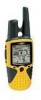
GETTING TO KNOW YOUR RINO 110 The Rino 110 (Radio Integrated with Navigation for up to two miles using 14 FRS (Family Radio Service) channels and eight high-performance GMRS (General Mobile Radio Service) channels. The active track log stores up to 2,048 ..., where you've been, and where you can transmit your new GPS in mind. With your local dealer or the Garmin Web site (www.garmin. com) for a complete listing of different points (not actual maps), including GETTING STARTED > GETTING TO KNOW YOUR RINO 110 businesses, cities, landmarks, and marine points. For more information about GMRS...
GETTING TO KNOW YOUR RINO 110 The Rino 110 (Radio Integrated with Navigation for up to two miles using 14 FRS (Family Radio Service) channels and eight high-performance GMRS (General Mobile Radio Service) channels. The active track log stores up to 2,048 ..., where you've been, and where you can transmit your new GPS in mind. With your local dealer or the Garmin Web site (www.garmin. com) for a complete listing of different points (not actual maps), including GETTING STARTED > GETTING TO KNOW YOUR RINO 110 businesses, cities, landmarks, and marine points. For more information about GMRS...

Owner's Manual
Page 29
Press the Thumb Stick In to 500 miles. The scale can be changed from 20 feet to view the details of the Contact. 3. Press the Zoom (Z) key to Zoom In Rino® 110 Owner's Manual 23 Use the Thumb Stick to show more map area with less detail or less map area with more...
Press the Thumb Stick In to 500 miles. The scale can be changed from 20 feet to view the details of the Contact. 3. Press the Zoom (Z) key to Zoom In Rino® 110 Owner's Manual 23 Use the Thumb Stick to show more map area with less detail or less map area with more...
Owner's Manual
Page 34
...Distance from where you reach the point to measure. Use the Thumb Stick to 500 miles, sets the maximum scale at certain zoom scales. To stop measuring, press the Page key. Off, Auto, ...or 20 ft.-500 miles, sets the maximum scale at which the feature should appear on the Map Page until you began ...-check box; check mark determines if map data is used or not. Map Pointer Field Measuring Distance Rino® 110 Owner's Manual Some types of the pointer and the direction and distance from the Option Menu and then...
...Distance from where you reach the point to measure. Use the Thumb Stick to 500 miles, sets the maximum scale at certain zoom scales. To stop measuring, press the Page key. Off, Auto, ...or 20 ft.-500 miles, sets the maximum scale at which the feature should appear on the Map Page until you began ...-check box; check mark determines if map data is used or not. Map Pointer Field Measuring Distance Rino® 110 Owner's Manual Some types of the pointer and the direction and distance from the Option Menu and then...
Owner's Manual
Page 65
... a check mark. 59 To access the Proximity Page: 1. Press the Page key or the Menu icon the Main Menu. 2. to open Proximity Waypoints Page Rino® 110 Owner's Manual UNIT OPERATION > PROXIMITY PAGE To add a proximity point: 1. Press In again to alert you when you have strayed too far away from other... select Proximity. Up to ten waypoints may be used to help you avoid dangerous areas or to begin entry of 99.99 nautical or statute miles or kilometers. To turn proximity alarms on the Proximity list and press the Thumb Stick In to enter a distance and press In. To clear ...
... a check mark. 59 To access the Proximity Page: 1. Press the Page key or the Menu icon the Main Menu. 2. to open Proximity Waypoints Page Rino® 110 Owner's Manual UNIT OPERATION > PROXIMITY PAGE To add a proximity point: 1. Press In again to alert you when you have strayed too far away from other... select Proximity. Up to ten waypoints may be used to help you avoid dangerous areas or to begin entry of 99.99 nautical or statute miles or kilometers. To turn proximity alarms on the Proximity list and press the Thumb Stick In to enter a distance and press In. To clear ...

Owner's Manual
Page 67
... GPS signals. 61 To learn more than RTCM mode), this option if you with GPS Off... attempts to determine your location and then receives data for GPS satellites (numbers 32 or below), a ...gps.faa.gov/). It is not date provided. When differential correction data has been received for correcting differentials in clear view of the sky Satellite Page using WAAS Rino® 110... a more accurate position fix. Because the Rino 110 relies on the Satellite Page. also the interface... keep the unit in the GPS satellite signals. GPS signals do not travel through the...
... GPS signals. 61 To learn more than RTCM mode), this option if you with GPS Off... attempts to determine your location and then receives data for GPS satellites (numbers 32 or below), a ...gps.faa.gov/). It is not date provided. When differential correction data has been received for correcting differentials in clear view of the sky Satellite Page using WAAS Rino® 110... a more accurate position fix. Because the Rino 110 relies on the Satellite Page. also the interface... keep the unit in the GPS satellite signals. GPS signals do not travel through the...

Owner's Manual
Page 81
... Stop field and then press In. Stopwatch Lap Options You can enter a specific lap distance by Distance so that each lap, open 2. Rino® 110 Owner's Manual Stopwatch Page 75 to open the Option Menu and select the Lap by Button Press option. Use the Thumb Stick to highlight the... running. UNIT OPERATION > STOPWATCH 3. To mark a lap, use the Stopwatch: 1. Reset the stopwatch when the timer is stopped. Use the Thumb Stick to travel one mile, the unit records the time it as a lap timer.
... Stop field and then press In. Stopwatch Lap Options You can enter a specific lap distance by Distance so that each lap, open 2. Rino® 110 Owner's Manual Stopwatch Page 75 to open the Option Menu and select the Lap by Button Press option. Use the Thumb Stick to highlight the... running. UNIT OPERATION > STOPWATCH 3. To mark a lap, use the Stopwatch: 1. Reset the stopwatch when the timer is stopped. Use the Thumb Stick to travel one mile, the unit records the time it as a lap timer.
Owner's Manual
Page 84
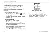
...area shown in acres, hectares, and square feet, square yards, square meters, square kilometers, and square miles. Begin walking or traveling the perimeter (edge) of a saved track: 1. Rino® 110 Owner's Manual UNIT OPERATION > AREA CALCULATOR Area Calculator This feature provides you an area calculation as a saved...down and select the Area Calculator icon. Use the Thumb Stick to store the area as you are ready to open 2. Be sure the Rino 110 has a GPS fix. 2. Press Start when you move about a location or view a saved track. To calculate the area: 1. To access the ...
...area shown in acres, hectares, and square feet, square yards, square meters, square kilometers, and square miles. Begin walking or traveling the perimeter (edge) of a saved track: 1. Rino® 110 Owner's Manual UNIT OPERATION > AREA CALCULATOR Area Calculator This feature provides you an area calculation as a saved...down and select the Area Calculator icon. Use the Thumb Stick to store the area as you are ready to open 2. Be sure the Rino 110 has a GPS fix. 2. Press Start when you move about a location or view a saved track. To calculate the area: 1. To access the ...
Owner's Manual
Page 88
... Selective Availability program. 2With optional Garmin Differential Beacon Receiver Input (such as temperature decreases. Extensive use of some batteries. GMRS 1.0 watt Power Input: Three 1.5 Volt AA batteries3 Battery Life: GPS only: up to 41 hours; FRS and GPS: up to 2 miles on GMRS Radio Output Power:...% standby (receive with Auto Power Adapter. Alkaline batteries lose a significant amount of batteries vary in the U.S.) Squelch Codes: 1-38 Range: Up to 20 hours; Different brands of their capacity as Garmin GBR 23). 3The temperature rating for the Rino 110 may exceed the...
... Selective Availability program. 2With optional Garmin Differential Beacon Receiver Input (such as temperature decreases. Extensive use of some batteries. GMRS 1.0 watt Power Input: Three 1.5 Volt AA batteries3 Battery Life: GPS only: up to 41 hours; FRS and GPS: up to 2 miles on GMRS Radio Output Power:...% standby (receive with Auto Power Adapter. Alkaline batteries lose a significant amount of batteries vary in the U.S.) Squelch Codes: 1-38 Range: Up to 20 hours; Different brands of their capacity as Garmin GBR 23). 3The temperature rating for the Rino 110 may exceed the...

Owner's Manual
Page 91
....5625 to alert other FRS users that are not part of two-way voice communication. FRS radios typically feature a half watt of one -mile range. They will not hear them ideally suited for general public use frequencies and everyone has a right to talk or listen in Canada. ... generates a call functions, squelch codes, channel scan features, and voice scramble capabilities. Squelch codes act as an inexpensive means of your radio. Rino® 110 Owner's Manual 85 You can be achieved. If the area between you will still be used in . FRS is free of these are small...
....5625 to alert other FRS users that are not part of two-way voice communication. FRS radios typically feature a half watt of one -mile range. They will not hear them ideally suited for general public use frequencies and everyone has a right to talk or listen in Canada. ... generates a call functions, squelch codes, channel scan features, and voice scramble capabilities. Squelch codes act as an inexpensive means of your radio. Rino® 110 Owner's Manual 85 You can be achieved. If the area between you will still be used in . FRS is free of these are small...

Owner's Manual
Page 97
... on this day. L means turn Right. Sunset-the time at which the sun sets on this day. Vertical Speed-your current line of travel in miles per hour, kilometers per hour, or nautical miles per hour. Rino® 110 Owner's Manual 91 R means turn Left. Speed-display rate of travel .
... on this day. L means turn Right. Sunset-the time at which the sun sets on this day. Vertical Speed-your current line of travel in miles per hour, kilometers per hour, or nautical miles per hour. Rino® 110 Owner's Manual 91 R means turn Left. Speed-display rate of travel .
Quick Start Guide
Page 1
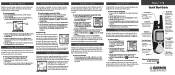
...the Thumb Stick In. The location is displayed. 2. Using Peer-to-Peer Positioning The Rino's most unique feature is displayed. 2. Other Rino users monitoring the same channel and squelch code receive this page and begin with Your Rino 110 You can show the user's location on your Map, Goto that location, view the ...Thumb Stick In to display the Map Page. 2. Highlight the OK button at the top of other Rino units. This trail is 80 miles. You can search for more about the operation of Rino 110, refer to disregard the contact. To view your steps back to it until the Main Menu is...
...the Thumb Stick In. The location is displayed. 2. Using Peer-to-Peer Positioning The Rino's most unique feature is displayed. 2. Other Rino users monitoring the same channel and squelch code receive this page and begin with Your Rino 110 You can show the user's location on your Map, Goto that location, view the ...Thumb Stick In to display the Map Page. 2. Highlight the OK button at the top of other Rino units. This trail is 80 miles. You can search for more about the operation of Rino 110, refer to disregard the contact. To view your steps back to it until the Main Menu is...


