Owner's Manual
Page 3
Oregon Series Owner's Manual i The small arrows (>) used in the text indicate that ...61579; Warning See the Important Safety and Product Information guide in the product box for using the following products: • Oregon 450 and 450t • Oregon 550 and 550t Tips and Shortcuts • Touch or to scroll and see , "Touch Where To? > Tracks," ... Manual Conventions When you should touch a series of items in a safe place. button on the screen. Go to http://my.garmin.com. For example, if you see more choices. • Touch to return to the previous screen. • Touch to ...
Oregon Series Owner's Manual i The small arrows (>) used in the text indicate that ...61579; Warning See the Important Safety and Product Information guide in the product box for using the following products: • Oregon 450 and 450t • Oregon 550 and 550t Tips and Shortcuts • Touch or to scroll and see , "Touch Where To? > Tracks," ... Manual Conventions When you should touch a series of items in a safe place. button on the screen. Go to http://my.garmin.com. For example, if you see more choices. • Touch to return to the previous screen. • Touch to ...
Owner's Manual
Page 23
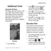
...record elevation changes over distance or time, or pressure (barometric or ambient) changes over time. Elevation Plot The Oregon can be found in some Garmin topographic cartography. Additional Tools Using the 3D View The Oregon 450t and 550t have a 3D view. Go to open the Elevation Plot page. • To adjust the distance...Tools • Touch to increase the angle of elevation, and touch to decrease the angle of elevation. • Touch to pan the 3D map forward, and touch to pan the 3D map backward. • Touch to rotate the view to the left, and touch to rotate the view to the right.
...record elevation changes over distance or time, or pressure (barometric or ambient) changes over time. Elevation Plot The Oregon can be found in some Garmin topographic cartography. Additional Tools Using the 3D View The Oregon 450t and 550t have a 3D view. Go to open the Elevation Plot page. • To adjust the distance...Tools • Touch to increase the angle of elevation, and touch to decrease the angle of elevation. • Touch to pan the 3D map forward, and touch to pan the 3D map backward. • Touch to rotate the view to the left, and touch to rotate the view to the right.


