Garmin Oregon 200 Support Question
Garmin Oregon 200 Support Question
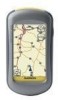
Find answers below for this question about Garmin Oregon 200 - Hiking GPS Receiver.Need a Garmin Oregon 200 manual? We have 4 online manuals for this item!
Question posted by damianpower on April 5th, 2013
Deletion Of Maps From Oregon 200
How do I delete maps from my Oregon 200 to free up memory7 space?
Current Answers
Related Garmin Oregon 200 Manual Pages
Important Product and Safety Information (Multilingual) - Page 3
... recycling of the FCC interference limits for help. Some state laws prohibit drivers from the GPS unit.
• Consult the dealer or an experienced radio/TV technician for Class B...Map Data Information: One of the goals of this device is subject to the following measures:
• Reorient or relocate the receiving antenna.
• Increase the separation between the equipment and the receiver...
Owner's Manual - Page 3
...of items in or zoom out. button on the Map page to the Main menu.
• Touch or on the screen, and then touch Tracks. Oregon Series Owner's Manual For example, if you...(>) used in the product box for using the following products:
• Oregon™ 200 • Oregon 300 • Oregon 400t, 400c, and 400i • Oregon 550 and 550t
Tips and Shortcuts
• Touch or to scroll and ...
Owner's Manual - Page 4
...by phone at +44 (0) 870.8501241. If needed, the serial number of available accessories and maps, refer to the Garmin Web site at (913) 397.8200 or (800) 800.1020. In... Garmin (Europe) Ltd.
Contact Garmin
Contact Garmin Product Support if you have any questions while using your Oregon is located in -country support information, or contact Garmin (Europe) Ltd. In Europe, go to www.garmin...
Owner's Manual - Page 5
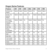
Oregon Series Features
Features
US Inland Lakes Mapping
200 300 400t 400c 400i Optional Optional Optional Optional Yes
550 550t Optional Optional
US, UK, or Aus BlueChart Mapping
Optional Optional Optional Yes
Optional Optional Optional
US, European, Aus, or Canada Topography
Altimeter
Audio Tones
Wireless Communication
RS-232/NMEA Serial
Alarm Clock
3-Axis ...
Owner's Manual - Page 6
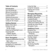
... vi
Getting Started 1 Battery Information 2 Turning On and
Off the Oregon 2 Adjusting the Backlight Level..... 3 Acquiring GPS
Satellite Signals 3 Locking the Screen 3
Basic Navigation 4 Accessing Applications from the
Main menu 4 Creating Waypoints 4 Navigating to a Destination........ 5 Stop Navigating 7
Using the Map 7 Using the Compass 9 Bearing and Course
Pointers 11
Managing...
Owner's Manual - Page 7

Trip Computer 22
GPS Games 23 Geocaches 23 Wherigo 23
Customizing the Oregon.. 24 Changing the Profile 24 Setting Up Profiles 24 Using System Setup 25 Customizing the Display.......... 26 Map Setup 26 Tracks Setup 27 Customizing the Main menu.... 28 Routing Setup 28 Changing the Camera
Settings 29 Changing Marine Settings........ 29 Changing...
Owner's Manual - Page 15
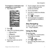
... are listed in order of distance from the following options:
• A Recent Find • A Waypoint. • My Current Location • A Map Point 4. Touch > Compass. 9.
Your current location
is indicated by a location marker . 2. Oregon Series Owner's Manual
Touch the location you selected.
6. Use the compass to navigate to
your course. 8. Touch . 3. Touch a destination...
Owner's Manual - Page 17
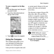
... a compass and a bearing pointer. Touch to ensure maximum accuracy.
It also provides navigation data such
Oregon Series Owner's Manual
Basic Navigation
as traveling in automobile, the compass uses GPS signals to the next point on the Map page: 1. Hold the compass level when navigating to save the waypoint. Touch the information button at...
Owner's Manual - Page 22
...> > to save the route.
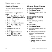
7. Editing and Deleting Routes
You can create and store up to 50 routes. Touch the first item on the map: 1. Repeat until the route is complete.
6.
Viewing...a different location.
• Review-shows the point on the map.
14
Oregon Series Owner's Manual Touch > Where To? > Routes to view > View Map.
To create and navigate a new route: 1. Touch a ...
Owner's Manual - Page 26
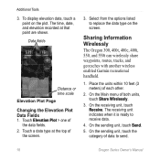
... 550t can wirelessly share waypoints, routes, tracks, and geocaches with another wireless enabled Garmin recreational handheld.
1. To display elevation data, touch a
point on the screen. The receiving unit indicates when it is ready to send.
18
Oregon Series Owner's Manual Data fields
Distance or time scale Elevation Plot Page Changing the Elevation Plot...
Owner's Manual - Page 32
....
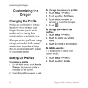
Touch . Touch Setup > Profiles. 2. Setting Up Profiles
To change the order of use .
Touch Move Up or Move Down. Touch a profile > Delete.
24
Oregon Series Owner's Manual
To change a profile 1. Touch Setup > Profiles. 2. Customizing the Oregon
Customizing the Oregon
Changing the Profile
Profiles are saved automatically as moving from one type of the profiles: 1.
Owner's Manual - Page 33
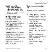
...not change the language of battery you to use the Oregon USB port with most NMEA 0183-compliant mapping programs by creating a virtual serial port.
• ...Oregon serial interface:
• Garmin Spanner-allows you are using. GPS-select Normal, WAAS (Wide Area Augmentation System), or Demo Mode (GPS off).
This profile is a copy of location and velocity information.
• RTCM -receive...
Owner's Manual - Page 39
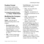
... Format
Use the default settings unless you are using a map or chart that specifies a different position format. Modifying the Compass
Touch Setup > Heading.
Customizing the Oregon
North Reference-select the north reference of directional heading shown ...as the heading reference (0°).
• User-allows you to a GPS compass when you are traveling
Oregon Series Owner's Manual 31
Owner's Manual - Page 44
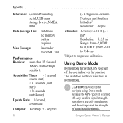
... using Demo mode because the GPS receiver is turned off for use ...Map Storage:
Internal or microSD Card
Performance Receiver...: more than 12 channel
WAAS enabled/High sensitivity
Acquisition Times: < 1 second (warm start) < 33 seconds (cold start) < 36 seconds (autolocate)
Update Rate: 1/second, continuous
Compass: Accuracy: ± 2 degrees
36
(± 5 degrees in Demo mode. Oregon...
Owner's Manual - Page 46

... cover
microSD card tray
microSD card
4. Replace the batteries and the battery cover.
Open MapSource on your Oregon and computer maps such as MapSource or maps accessed on mapping Web sites, such as Google™ Maps. Click Receive From Device... To remove the microSD card, lift the metal cover and remove the card from the microSD...
Owner's Manual - Page 47
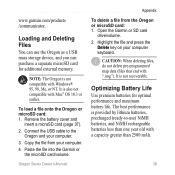
... deleting files, do not delete pre-programmed map data (files that end with Windows® 95, 98, Me, or NT. Oregon Series Owner's Manual 39 Note: The Oregon is provided by lithium batteries, precharged (ready-to the Oregon and your computer.
3. Highlight the file and press the Delete key on your computer.
4.
To load a file onto the Oregon...
Owner's Manual - Page 51
Index
Index
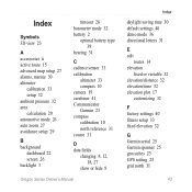
Symbols 3D view 23
A accessories ii active route 15 advanced map setup 27 alarms, marine 30 altimeter
calibration 33 setup 32 ambient pressure 32 area calculation 20 automotive mode 26 auto zoom ...plot 17
customizing 32
F factory settings 40 fitness setup 33 fixed elevation 32
G Garmin serial 25 Garmin spanner 25 geocaches 23 GPS setting 25 grid north 31
Oregon Series Owner's Manual 43
Quick Reference Guide - Page 3
... several months. Touch or to an open area,
away from tall buildings and trees.
2.
Oregon Series Quick Start Manual
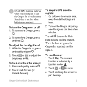
To acquire GPS satellite signals: 1. Acquiring satellite signals can take a few minutes. Touch Map. Touch or to pan the map.
Stored data is indicated by a location marker .
2.
To lock or unlock the screen: 1. Touch Lock...
Quick Reference Guide - Page 4
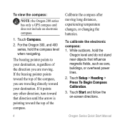
... Compass Calibration. 3. If the bearing pointer points toward the top of the compass.
Calibrate the compass after moving .
To view the compass:
Note: the Oregon 200 series has only a GPS compass and does not include an electronic compass.
1. To calibrate the electronic compass: 1. The bearing pointer points to your destination. Touch Compass. 2. Touch...
Quick Reference Guide - Page 5
...other attributes, if necessary.
6. Touch to change.
4.
Oregon Series Quick Start Manual
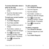
To review information about a point on the map: 1. Touch Mark Waypoint.
2.
Touch letters, numbers,...other attributes, if necessary.
6.
Touch letters, numbers, or symbols to delete.
3. Touch Waypoint Manager.
2. Touch Delete Waypoint. Touch the information button at the top of the screen. ...
Similar Questions


Oregon 200 Question.
I downloaded a map to a MicroSD card. I put it in the receiver. How do I get the Oregon to read the ...
I downloaded a map to a MicroSD card. I put it in the receiver. How do I get the Oregon to read the ...
(Posted by rmccutcheon79 13 years ago)