
Declaration of Conformity
Page 1
GARMIN (Europe) Ltd, The Quadrangle, Abbey Park Ind. Global Positioning System Receiver GPSMAP 60 MONO GPS 60 The undersigned does hereby declare that the equipment complies to which Conformity is Declared: 89/336/EEC, 1999/5/EC EN 55022:1998 ..., Romsey, Hampshire, SO51 9DL, U.K. Issued: 09/07/2004 Revised: 20/09/2005 Page: 1 of 1 DECLARATION of CONFORMITY Application of Equipment: Model Number(s): GARMIN International & GARMIN Corporation 1200 E. 151st Street No.68, Jangshu 2nd Rd., Olathe, Kansas 66062 Shijr, Taipei County, U.S.A TAIWAN, R.O.C. Paul Morrow Quality Manager...
GARMIN (Europe) Ltd, The Quadrangle, Abbey Park Ind. Global Positioning System Receiver GPSMAP 60 MONO GPS 60 The undersigned does hereby declare that the equipment complies to which Conformity is Declared: 89/336/EEC, 1999/5/EC EN 55022:1998 ..., Romsey, Hampshire, SO51 9DL, U.K. Issued: 09/07/2004 Revised: 20/09/2005 Page: 1 of 1 DECLARATION of CONFORMITY Application of Equipment: Model Number(s): GARMIN International & GARMIN Corporation 1200 E. 151st Street No.68, Jangshu 2nd Rd., Olathe, Kansas 66062 Shijr, Taipei County, U.S.A TAIWAN, R.O.C. Paul Morrow Quality Manager...
Owner's Manual
Page 3
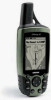
...through the process of navigating with additional information about your GPSmap 60. or by phone at sales@garmin.com. iii GPS Features-provides detailed descriptions of the GPSmap 60 functional features. Getting Started- contact Garmin Product Support by e-mail at 913-397-8200 or 800-... have any difficulty while using the unit control buttons, initializing the GPS receiver, etc. Friday, 8 am - 5 pm Central Time; GPSmap 60 Introduction Preface Contact Garmin If you for choosing the Garmin GPSmap 60 handheld navigation system. at 44/1794.519944. In Europe, contact...
...through the process of navigating with additional information about your GPSmap 60. or by phone at sales@garmin.com. iii GPS Features-provides detailed descriptions of the GPSmap 60 functional features. Getting Started- contact Garmin Product Support by e-mail at 913-397-8200 or 800-... have any difficulty while using the unit control buttons, initializing the GPS receiver, etc. Friday, 8 am - 5 pm Central Time; GPSmap 60 Introduction Preface Contact Garmin If you for choosing the Garmin GPSmap 60 handheld navigation system. at 44/1794.519944. In Europe, contact...
Owner's Manual
Page 7
.... MAP DATA INFORMATION: One of the goals of Garmin is to provide customers with California's Proposition 65. WARNING: This product, its packaging, and its accuracy and maintenance. We use a combination of governmental and private data sources, which could affect the accuracy and performance of California to us at http://www.garmin. GPSmap 60 Introduction...
.... MAP DATA INFORMATION: One of the goals of Garmin is to provide customers with California's Proposition 65. WARNING: This product, its packaging, and its accuracy and maintenance. We use a combination of governmental and private data sources, which could affect the accuracy and performance of California to us at http://www.garmin. GPSmap 60 Introduction...
Owner's Manual
Page 9
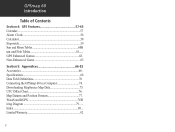
... 39 The Highway Page 44 The Setup Menu 45 System Setup 45 Interface Setup 46 Tones Setup 48 Page Sequence Setup 48 Map Setup 49 Routing Setup 52 Geocache Setup 53 Marine Setup 53 Time Setup 54 Units Setup 54 Heading Setup 55 Welcome Page ... 3... The Main Page Features 7 Table of Contents vii-viii Section 2: Getting Started 1-7 Battery Installation and Start Up 1 . Key Functions 2 .. GPSmap 60 Introduction Section 1: Introduction i-viii Preface i Software License Agreement ii FCC Compliance Information iii Warnings and Precautions iv-vi Table of Contents Section...
... 39 The Highway Page 44 The Setup Menu 45 System Setup 45 Interface Setup 46 Tones Setup 48 Page Sequence Setup 48 Map Setup 49 Routing Setup 52 Geocache Setup 53 Marine Setup 53 Time Setup 54 Units Setup 54 Heading Setup 55 Welcome Page ... 3... The Main Page Features 7 Table of Contents vii-viii Section 2: Getting Started 1-7 Battery Installation and Start Up 1 . Key Functions 2 .. GPSmap 60 Introduction Section 1: Introduction i-viii Preface i Software License Agreement ii FCC Compliance Information iii Warnings and Precautions iv-vi Table of Contents Section...
Owner's Manual
Page 10
Specifications 68 Data Field Definitions 70 Connecting the GPSmap 60 to a Computer 74 . Index 80 ... GPSmap 60 Introduction Table of Contents Section 4: GPS Features 57-65 Calendar 57 Alarm Clock 58 Calculator 58 Stopwatch 59 Sun and Moon Tables 60H unt and Fish Tables 61.... WAAS and DGPS 78W iring Diagram 79 ..... GPS Enhanced Games 62 . Non-Enhanced Game 65 Section 5: Appendices 66-82 Accessories 66 . Downloading MapSource Map Data 75 UTC Offset Chart 76 . Map Datums and Position Formats 77 . Limited Warranty 82 x
Specifications 68 Data Field Definitions 70 Connecting the GPSmap 60 to a Computer 74 . Index 80 ... GPSmap 60 Introduction Table of Contents Section 4: GPS Features 57-65 Calendar 57 Alarm Clock 58 Calculator 58 Stopwatch 59 Sun and Moon Tables 60H unt and Fish Tables 61.... WAAS and DGPS 78W iring Diagram 79 ..... GPS Enhanced Games 62 . Non-Enhanced Game 65 Section 5: Appendices 66-82 Accessories 66 . Downloading MapSource Map Data 75 UTC Offset Chart 76 . Map Datums and Position Formats 77 . Limited Warranty 82 x
Owner's Manual
Page 13
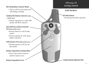
...or DC power adapter connection. External Power and Data Connector Port (under weather cover) • Provides interface to a remote GPS antenna with MCX connector. Auxiliary Mount Alignment Slots 3 USB Connector Port (under weather cover) • Provides connection to a... PC for convenient access when hiking or walking. Auxiliary GPS Antenna Connector (under weather cover) • Provides interface to remove cover. Battery Compartment Cover GPSmap 60 Getting Started Unit Features GPS Helix Antenna • Provides quick satellite acquisition. Battery Compartment Locking ...
...or DC power adapter connection. External Power and Data Connector Port (under weather cover) • Provides interface to a remote GPS antenna with MCX connector. Auxiliary Mount Alignment Slots 3 USB Connector Port (under weather cover) • Provides connection to a... PC for convenient access when hiking or walking. Auxiliary GPS Antenna Connector (under weather cover) • Provides interface to remove cover. Battery Compartment Cover GPSmap 60 Getting Started Unit Features GPS Helix Antenna • Provides quick satellite acquisition. Battery Compartment Locking ...
Owner's Manual
Page 14
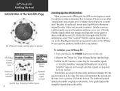
...the array. To initialize your position centered in order to determine your general location so the GPSmap 60 can search for just those satellites above its position GPS Status/ Current Location Field Options Menu Position of overhead satellites Received satellite signal strength Satellite Page Displaying...bar graph displays the strength of the sky. Thereafter, if you can take up to 15 minutes the first time you use the Map Page to determine (fix) its location. To shorten the time required for the satellite signals, a "Locating Satellites" message followed by the...
...the array. To initialize your position centered in order to determine your general location so the GPSmap 60 can search for just those satellites above its position GPS Status/ Current Location Field Options Menu Position of overhead satellites Received satellite signal strength Satellite Page Displaying...bar graph displays the strength of the sky. Thereafter, if you can take up to 15 minutes the first time you use the Map Page to determine (fix) its location. To shorten the time required for the satellite signals, a "Locating Satellites" message followed by the...

Owner's Manual
Page 15
... position accuracy and location coordinates. GPSmap 60 Getting Started Initialization & The Satellite Page Map Item Details Position Arrow Map Scale Map Pointer Map Page with Current Position Arrow Navigating with a route line, and leaves a trail (track log) of other features. Track - A previous path of the page will change to begin GPS-aided navigation. 4. The Trip Computer...
... position accuracy and location coordinates. GPSmap 60 Getting Started Initialization & The Satellite Page Map Item Details Position Arrow Map Scale Map Pointer Map Page with Current Position Arrow Navigating with a route line, and leaves a trail (track log) of other features. Track - A previous path of the page will change to begin GPS-aided navigation. 4. The Trip Computer...
Owner's Manual
Page 18
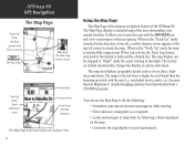
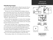
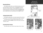
... as rivers, lakes, highways and towns. residential streets, parks, etc.) because Garmin MapSource® detailed mapping data has been downloaded from a CD-ROM program. GPSmap 60 GPS Navigation The Map Page "North Up" Mode with Map oriented with North at the top The Map Scale The Map Page Position Arrow "Track Up" Mode North Orientation Arrow Data Fields...
... as rivers, lakes, highways and towns. residential streets, parks, etc.) because Garmin MapSource® detailed mapping data has been downloaded from a CD-ROM program. GPSmap 60 GPS Navigation The Map Page "North Up" Mode with Map oriented with North at the top The Map Scale The Map Page Position Arrow "Track Up" Mode North Orientation Arrow Data Fields...
Owner's Manual
Page 19
... Icon." When using MapSource detailed maps, "mapsource" appears below the map scale. Optional data fields can show more map area with less detail or less map area with the item highlighted on the map and on the display screen. GPSmap 60 GPS Navigation The Map Page Zoom In Zoom Out Map Features Map Scales Accuracy Circle Panning Arrow Guidance...
... Icon." When using MapSource detailed maps, "mapsource" appears below the map scale. Optional data fields can show more map area with less detail or less map area with the item highlighted on the map and on the display screen. GPSmap 60 GPS Navigation The Map Page Zoom In Zoom Out Map Features Map Scales Accuracy Circle Panning Arrow Guidance...
Owner's Manual
Page 20
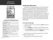
...active navigation. Guidance Text - Displays messages on the map and reduce the amount of map clutter (map item icons and names) to display the type of navigation information you to a destination. GPSmap 60 GPS Navigation The Map Page The Map Page Options Menu A Quick Look at the top ...of the page showing Speed, Heading, Elevation and Time. Recalculate - Allows two to four fields to display the Map Page Options Menu. 3. Measure Distance ...
...active navigation. Guidance Text - Displays messages on the map and reduce the amount of map clutter (map item icons and names) to display the type of navigation information you to a destination. GPSmap 60 GPS Navigation The Map Page The Map Page Options Menu A Quick Look at the top ...of the page showing Speed, Heading, Elevation and Time. Recalculate - Allows two to four fields to display the Map Page Options Menu. 3. Measure Distance ...
Owner's Manual
Page 21
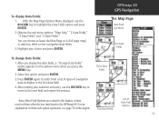
... highlight the Data Fields option and press ENTER. 2. For an explanation of what each option represents, see page 70 of Data Field Options 11 GPSmap 60 GPS Navigation The Map Page Data Field Sub-Menu Two Data Fields To change Data Fields: 1. Select this option and press ENTER. 3. Observe the sub-menu options...
... highlight the Data Fields option and press ENTER. 2. For an explanation of what each option represents, see page 70 of Data Field Options 11 GPSmap 60 GPS Navigation The Map Page Data Field Sub-Menu Two Data Fields To change Data Fields: 1. Select this option and press ENTER. 3. Observe the sub-menu options...
Owner's Manual
Page 22
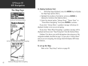
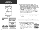
...described on page 49. 12 Guidance Message when navigating With Map Page displayed, press the MENU key to activate. Guidance Text shows you are navigating. GPSmap 60 GPS Navigation The Map Page Guidance Text Options Menu GPS Status Message when not navigating To display Guidance Text: 1.... Highlight the Guidance Text Option and press ENTER to the "Map Setup" section on page 5. If you select "...
...described on page 49. 12 Guidance Message when navigating With Map Page displayed, press the MENU key to activate. Guidance Text shows you are navigating. GPSmap 60 GPS Navigation The Map Page Guidance Text Options Menu GPS Status Message when not navigating To display Guidance Text: 1.... Highlight the Guidance Text Option and press ENTER to the "Map Setup" section on page 5. If you select "...
Owner's Manual
Page 23
... titles and icons that clutter the view of roadways, especially when the map is zoomed in. GPSmap 60 GPS Navigation The Map Page Measured Distance Turning Declutter On/Off This Map Page option allows you to activate. The "Measure Distance" Option Enabled Map Declutter "Off" Map Declutter "On" 13 Restoring Default Settings This option allows you to...
... titles and icons that clutter the view of roadways, especially when the map is zoomed in. GPSmap 60 GPS Navigation The Map Page Measured Distance Turning Declutter On/Off This Map Page option allows you to activate. The "Measure Distance" Option Enabled Map Declutter "Off" Map Declutter "On" 13 Restoring Default Settings This option allows you to...
Owner's Manual
Page 24
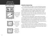
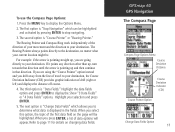
... compass indicates the direction you are moving. Course Pointer The Course Pointer indicates your unit for guidance. This is your destination. GPSmap 60 GPS Navigation The Compass Page Compass Page The Compass Ring moves to indicate North orientation when you are heading. Using the Compass Page The ...Compass Page is especially helpful when using a paper map in each from three or four data fields and select the type of data displayed in conjunction with your course of movement and...
... compass indicates the direction you are moving. Course Pointer The Course Pointer indicates your unit for guidance. This is your destination. GPSmap 60 GPS Navigation The Compass Page Compass Page The Compass Ring moves to indicate North orientation when you are heading. Using the Compass Page The ...Compass Page is especially helpful when using a paper map in each from three or four data fields and select the type of data displayed in conjunction with your course of movement and...
Owner's Manual
Page 25
... the line of the first data field on changing data fields. For example: if the arrow is displayed in that direction. GPSmap 60 GPS Navigation The Compass Page Compass Page Options Menu Course Deviation Distance Course Deviation Indicator (CDI) Course Pointer Option Change Data Fields Option 15 If you...
... the line of the first data field on changing data fields. For example: if the arrow is displayed in that direction. GPSmap 60 GPS Navigation The Compass Page Compass Page Options Menu Course Deviation Distance Course Deviation Indicator (CDI) Course Pointer Option Change Data Fields Option 15 If you...
Owner's Manual
Page 26
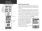
... the "Apply" button and press ENTER. Before each trip, a "Reset" option is done in the same manner as for the data fields on the Map Page. (See page 11 for details.) If you want to record new data for resetting trip computer data, clearing the Track Log and deleting Saved... you want to change. This page allows you with larger displays. Answer "OK" to the Yes/Cancel prompt and press ENTER to factory settings. GPSmap 60 GPS Navigation The Trip Computer Page Select "Change Data Fields" or press the ROCKER key to highlight a field you want to view significant...
... the "Apply" button and press ENTER. Before each trip, a "Reset" option is done in the same manner as for the data fields on the Map Page. (See page 11 for details.) If you want to record new data for resetting trip computer data, clearing the Track Log and deleting Saved... you want to change. This page allows you with larger displays. Answer "OK" to the Yes/Cancel prompt and press ENTER to factory settings. GPSmap 60 GPS Navigation The Trip Computer Page Select "Change Data Fields" or press the ROCKER key to highlight a field you want to view significant...
Owner's Manual
Page 27
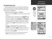
...an identifying symbol to a waypoint, use the ROCKER key to highlight the waypoint name field and press ENTER to display the on the GPSmap 60. The Mark Waypoint Page The Mark Waypoint Page allows you to mark and record your current (or any other) location as a new waypoint, ... next to the waypoint name and press ENTER to select a name for that has already been used, a "Waypoint Already Exits" message will appear. GPSmap 60 GPS Navigation Using Waypoints MARK Press the MARK key to acknowledge and choose a new name. 3. To save it as a waypoint and displays a name for the...
...an identifying symbol to a waypoint, use the ROCKER key to highlight the waypoint name field and press ENTER to display the on the GPSmap 60. The Mark Waypoint Page The Mark Waypoint Page allows you to mark and record your current (or any other) location as a new waypoint, ... next to the waypoint name and press ENTER to select a name for that has already been used, a "Waypoint Already Exits" message will appear. GPSmap 60 GPS Navigation Using Waypoints MARK Press the MARK key to acknowledge and choose a new name. 3. To save it as a waypoint and displays a name for the...
Owner's Manual
Page 28
... to display a new waypoint page. Do you want to the Find Menu Waypoints List. Select "Yes" and press ENTER to display the Map Page showing the path from your current location to display the information page. Typically, this point. Press ENTER to the MOB point. To... press ENTER to save it to create a user waypoint here?". If there is the Man Overboard (MOB) feature. GPSmap 60 GPS Navigation Using Waypoints Map Item selected as a waypoint. If the map selected does not contain any information, a message will highlight momentarily and display a name or address. 2.
... to display a new waypoint page. Do you want to the Find Menu Waypoints List. Select "Yes" and press ENTER to display the Map Page showing the path from your current location to display the information page. Typically, this point. Press ENTER to the MOB point. To... press ENTER to save it to create a user waypoint here?". If there is the Man Overboard (MOB) feature. GPSmap 60 GPS Navigation Using Waypoints Map Item selected as a waypoint. If the map selected does not contain any information, a message will highlight momentarily and display a name or address. 2.
Owner's Manual
Page 29
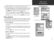
...and save the changes. A waypoint location can be averaged over time: 1. Refer to page 21 for more accuracy, but only while the GPS has a fix on using the waypoint symbol chart and alpha/numeric keypad to display the page options menu. 3. It will begin to ...Editing a Waypoint A waypoint can be selected from the Find Feature Waypoints list and edited to change the map symbol, name, location coordinates, elevation or to delete it . GPSmap 60 GPS Navigation Using Waypoints Waypoint Symbols Chart Delete Button Waypoint Options Menu Average Location Page 19 To average a Waypoint ...
...and save the changes. A waypoint location can be averaged over time: 1. Refer to page 21 for more accuracy, but only while the GPS has a fix on using the waypoint symbol chart and alpha/numeric keypad to display the page options menu. 3. It will begin to ...Editing a Waypoint A waypoint can be selected from the Find Feature Waypoints list and edited to change the map symbol, name, location coordinates, elevation or to delete it . GPSmap 60 GPS Navigation Using Waypoints Waypoint Symbols Chart Delete Button Waypoint Options Menu Average Location Page 19 To average a Waypoint ...

