Owner's Manual
Page 7
... contain inaccurate or incomplete data to some degree. The system is either not available or prohibitively expensive. MAP DATA INFORMATION: One of the goals of Garmin is to provide customers with the most complete and accurate cartography that is being provided in product literature..., therefore, become unsafe. com/prop65. We use a combination of California to our web site at a reasonable cost. Although the Garmin GPSmap 60 is solely responsible for its components contain chemicals known to the State of governmental and private data sources, which is a precision electronic ...
... contain inaccurate or incomplete data to some degree. The system is either not available or prohibitively expensive. MAP DATA INFORMATION: One of the goals of Garmin is to provide customers with the most complete and accurate cartography that is being provided in product literature..., therefore, become unsafe. com/prop65. We use a combination of California to our web site at a reasonable cost. Although the Garmin GPSmap 60 is solely responsible for its components contain chemicals known to the State of governmental and private data sources, which is a precision electronic ...
Owner's Manual
Page 18
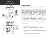
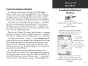
... the ROCKER key and view your current location. When you to your path of the GPSmap 60. The map display can use the Map Page to map items by a dotted line. residential streets, parks, etc.) because Garmin MapSource® detailed mapping data has been downloaded from a CD-ROM program. The factory set default automatically changes the...
... the ROCKER key and view your current location. When you to your path of the GPSmap 60. The map display can use the Map Page to map items by a dotted line. residential streets, parks, etc.) because Garmin MapSource® detailed mapping data has been downloaded from a CD-ROM program. The factory set default automatically changes the...
Owner's Manual
Page 31
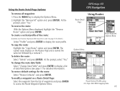
If you have downloaded Garmin MapSource mapping data that contains additional map detail, you can search for Points of 50 last found , you can effectively shorten your current location or the Panning Arrow (if active). • To save effort in the GPSmap 60 basemaps. Options Menu for Waypoints Find Menu Options ...the last selected category at the top of all categories. The options menu for those items near your search. * Refer to the Garmin website: http://www.garmin.com//cartography/mapSource/ bluechartCD.jsp GPSmap 60 GPS Navigation FIND Press the FIND key to the Find Menu.
If you have downloaded Garmin MapSource mapping data that contains additional map detail, you can search for Points of 50 last found , you can effectively shorten your current location or the Panning Arrow (if active). • To save effort in the GPSmap 60 basemaps. Options Menu for Waypoints Find Menu Options ...the last selected category at the top of all categories. The options menu for those items near your search. * Refer to the Garmin website: http://www.garmin.com//cartography/mapSource/ bluechartCD.jsp GPSmap 60 GPS Navigation FIND Press the FIND key to the Find Menu.
Owner's Manual
Page 53
... to display the Options Menu. 2. Press the MENU key to display the route profile. At the prompt, select "Yes." GPSmap 60 GPS Navigation Using Routes Route Detail Page Route Waypoint Options Menu Options Menu Route Vertical Profile using U.S. To copy the route: Highlight the..., select "Yes." Highlight the "Remove All" option and press ENTER. To create a vertical profile of the route: (Available only if Garmin MapSource DEM map data is named the same but followed by a numeral 1. Topo 24K DEM mapping data 43 To delete the route: Select "Delete" and press ENTER.
... to display the Options Menu. 2. Press the MENU key to display the route profile. At the prompt, select "Yes." GPSmap 60 GPS Navigation Using Routes Route Detail Page Route Waypoint Options Menu Options Menu Route Vertical Profile using U.S. To copy the route: Highlight the..., select "Yes." Highlight the "Remove All" option and press ENTER. To create a vertical profile of the route: (Available only if Garmin MapSource DEM map data is named the same but followed by a numeral 1. Topo 24K DEM mapping data 43 To delete the route: Select "Delete" and press ENTER.
Owner's Manual
Page 57
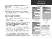
...If "User" is automatically detected and communicates only in the bottom of standard NMEA 0183 version 3.01 data. GPSmap 60 GPS Navigation Interface Setup Data Format Page for GARMIN DGPS Data Format Page for RTCM In/NMEA Out Data Format Page for available beacon transmitters. Access the Interface Setup ...RTCM In/Text Out - The beacon status, signal-to-noise ratio and distance to the GPS map 60, it is selected, select the "Freq" and "Bit Rate" fields and enter the appropriate settings. For Garmin DGPS or RTCM In/NMEA Out, use the ROCKER key to select "Scan" or "User" ...
...If "User" is automatically detected and communicates only in the bottom of standard NMEA 0183 version 3.01 data. GPSmap 60 GPS Navigation Interface Setup Data Format Page for GARMIN DGPS Data Format Page for RTCM In/NMEA Out Data Format Page for available beacon transmitters. Access the Interface Setup ...RTCM In/Text Out - The beacon status, signal-to-noise ratio and distance to the GPS map 60, it is selected, select the "Freq" and "Bit Rate" fields and enter the appropriate settings. For Garmin DGPS or RTCM In/NMEA Out, use the ROCKER key to select "Scan" or "User" ...
Owner's Manual
Page 76
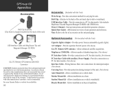
... connections for data transfer. (Not shown) Interface Cable - GPSmap 60 Appendices Accessories Belt Clip Assembly (Clip Knob is not recommended. Accessories offered for sale by Garmin for use with Garmin products. Start up instructions and detailed operation reference. Allows enhanced satellite...Provides convenient method for data transfer. USB Interface Cable - Provides connection to belt or waistband. Owner's Manual - Abbreviated overview of detailed map data. (Not shown) PC Interface Cable - Provides power from AC power. (Not shown) GA 27C Remote GPS Antenna - A/C ...
... connections for data transfer. (Not shown) Interface Cable - GPSmap 60 Appendices Accessories Belt Clip Assembly (Clip Knob is not recommended. Accessories offered for sale by Garmin for use with Garmin products. Start up instructions and detailed operation reference. Allows enhanced satellite...Provides convenient method for data transfer. USB Interface Cable - Provides connection to belt or waistband. Owner's Manual - Abbreviated overview of detailed map data. (Not shown) PC Interface Cable - Provides power from AC power. (Not shown) GA 27C Remote GPS Antenna - A/C ...

Owner's Manual
Page 79
...sec steady state Dynamics: Performs to specifications to 100m 2DRMS under the U.S. With optional Garmin GBR 21 Beacon Receiver input. 4. freezing conditions. Extensive use )4 Specifications subject to ...PC interface Data Storage Life: Indefinite: no memory battery required Map Storage: Internal; DoD imposed Selective Availability (SA) Program. 3. The temperature rating... use of screen backlighting and/or audible GPSmap 60 Appendices Specifications 69 Use Lithium batteries when operating the GPSmap 60 in below- approximately 24 MB POWER Source: ...
...sec steady state Dynamics: Performs to specifications to 100m 2DRMS under the U.S. With optional Garmin GBR 21 Beacon Receiver input. 4. freezing conditions. Extensive use )4 Specifications subject to ...PC interface Data Storage Life: Indefinite: no memory battery required Map Storage: Internal; DoD imposed Selective Availability (SA) Program. 3. The temperature rating... use of screen backlighting and/or audible GPSmap 60 Appendices Specifications 69 Use Lithium batteries when operating the GPSmap 60 in below- approximately 24 MB POWER Source: ...
Owner's Manual
Page 84
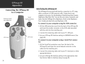
... port. 2. Set your computer using a Serial Port connector: 1. Lift the Serial Port protective cover from the GPSmap 60 to your GPSmap 60 interface setting to GARMIN format. (See page 46.) To connect to MapSource. Refer to your computer is provided with interface connection to your ...detailed map from the back of the GPSmap 60 and insert the round indexed connector on page 46. Set your GPSmap 60 interface setting to your MapSource CDs. Connect the remaining cable end to the appropriate interface format. Lift the USB protective cover from Garmin MapSource Map Data ...
... port. 2. Set your computer using a Serial Port connector: 1. Lift the Serial Port protective cover from the GPSmap 60 to your GPSmap 60 interface setting to GARMIN format. (See page 46.) To connect to MapSource. Refer to your computer is provided with interface connection to your ...detailed map from the back of the GPSmap 60 and insert the round indexed connector on page 46. Set your GPSmap 60 interface setting to your MapSource CDs. Connect the remaining cable end to the appropriate interface format. Lift the USB protective cover from Garmin MapSource Map Data ...
Owner's Manual
Page 85
... from most MapSource products. The GPSmap 60 accepts up to 56 MB of map data from a topo map to a MetroGuide map. Transferring MapSource Map Data If you have purchased a Garmin MapSource CD-ROM mapping program you may want to transfer detailed map data before beginning use to provide your Garmin Dealer or the Garmin website to determine the order of...
... from most MapSource products. The GPSmap 60 accepts up to 56 MB of map data from a topo map to a MetroGuide map. Transferring MapSource Map Data If you have purchased a Garmin MapSource CD-ROM mapping program you may want to transfer detailed map data before beginning use to provide your Garmin Dealer or the Garmin website to determine the order of...

Owner's Manual
Page 87
... to ensure the most USGS topographic quadrangle maps. What is physically represented by all Garmin units. The most of the Earth and enables calculations to a specific map datum. Appendix E What are Map Datums, and which should I use? GPSmap 60 Appendices Map Datums and Position Formats Map Datums are based on a map or chart are referenced to be viewed...
... to ensure the most USGS topographic quadrangle maps. What is physically represented by all Garmin units. The most of the Earth and enables calculations to a specific map datum. Appendix E What are Map Datums, and which should I use? GPSmap 60 Appendices Map Datums and Position Formats Map Datums are based on a map or chart are referenced to be viewed...
Quick Start Guide
Page 1
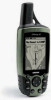
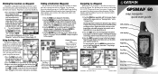
...until the desired waypoint is the heading (N, S, E, W). Using the Map Page The Map Page displays a detailed map of Interest (restaurant, museum, etc.) available from the Find Feature database. Without downloaded detailed map data from Garmin MapSource®, only waypoints, cities, interstate exits and geocache points can ... for that waypoint. 4. Waypoints List Navigating to a Waypoint When using the Find Menu. A Printed in Taiwan ® GPSMAP 60 map navigator quick start guide GPS Antenna Power Key LCD Display In/Out (Zoom) Keys Page Key Rocker Key Find Key Mark Key ...
...until the desired waypoint is the heading (N, S, E, W). Using the Map Page The Map Page displays a detailed map of Interest (restaurant, museum, etc.) available from the Find Feature database. Without downloaded detailed map data from Garmin MapSource®, only waypoints, cities, interstate exits and geocache points can ... for that waypoint. 4. Waypoints List Navigating to a Waypoint When using the Find Menu. A Printed in Taiwan ® GPSMAP 60 map navigator quick start guide GPS Antenna Power Key LCD Display In/Out (Zoom) Keys Page Key Rocker Key Find Key Mark Key ...


