

Owner's Manual
Page 49
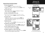
..." and "Hide Symbols" options. The beginning of the page and the distance from Digital Elevation Models (DEM) maps (MapSource U.S. Press the MENU key to display the Track Profile. GPSmap 76C GPS Navigation Using Tracks View Profile Page Option Track Profile Page Zoom Ranges Page 39... scroll across the profile by the DEM map data loaded on the profile is displayed at the bottom. 3. Topo 24K maps. At any point along the profile, you select "Profile". See page 77 for each point on your GPSmap 76C. To view a Track Profile: 1. A ...
..." and "Hide Symbols" options. The beginning of the page and the distance from Digital Elevation Models (DEM) maps (MapSource U.S. Press the MENU key to display the Track Profile. GPSmap 76C GPS Navigation Using Tracks View Profile Page Option Track Profile Page Zoom Ranges Page 39... scroll across the profile by the DEM map data loaded on the profile is displayed at the bottom. 3. Topo 24K maps. At any point along the profile, you select "Profile". See page 77 for each point on your GPSmap 76C. To view a Track Profile: 1. A ...
Owner's Manual
Page 55
... press ENTER. Topo 24K DEM mapping data 45 Using the Route Detail Page Options: To remove all waypoints: 1. Highlight the "Remove All' option and press ENTER. To create a vertical profile of the route: (Available only if Garmin MapSource DEM map data is named the same but followed by a numeral 1. GPSmap 76C GPS Navigation Using...
... press ENTER. Topo 24K DEM mapping data 45 Using the Route Detail Page Options: To remove all waypoints: 1. Highlight the "Remove All' option and press ENTER. To create a vertical profile of the route: (Available only if Garmin MapSource DEM map data is named the same but followed by a numeral 1. GPSmap 76C GPS Navigation Using...
Owner's Manual
Page 87
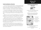
...les. GPSmap 76C Appendix Downloading MapSource Map Data Garmin MapSource CD-ROM's offer a variety of Interest database provided with the GPSmap 76C. Because new maps are designed to determine the order of Personal Waypoints, Routes and Saved Tracks. This includes the Marine Points of detailed mapping data...MapSource User's Manual. Maps that are at : www.garmin.com for storage and safety backup of hierarchy. Note that certain features contained in the MapSource hierarchy displays over the other). Topo 24K Digital Elevation Models (DEM) Maps provide elevation data at...
...les. GPSmap 76C Appendix Downloading MapSource Map Data Garmin MapSource CD-ROM's offer a variety of Interest database provided with the GPSmap 76C. Because new maps are designed to determine the order of Personal Waypoints, Routes and Saved Tracks. This includes the Marine Points of detailed mapping data...MapSource User's Manual. Maps that are at : www.garmin.com for storage and safety backup of hierarchy. Note that certain features contained in the MapSource hierarchy displays over the other). Topo 24K Digital Elevation Models (DEM) Maps provide elevation data at...


