

Owner's Manual
Page 8
...a car) as waypoints and routes, are used, apply the liquid to the unit. Water Immersion The GPSMAP 60CSx is always a good practice to back up important user data by manually recording it or downloading it to a PC (transferring it to wipe and air dry the unit before ...reuse or charging. vi GPSMAP 60CSx Owner's Manual User information, such as permanent damage may damage plastic components. If these are retained in 1 meter of high-quality materials and does not require user maintenance except cleaning. Prolonged submersion can withstand immersion in the...
...a car) as waypoints and routes, are used, apply the liquid to the unit. Water Immersion The GPSMAP 60CSx is always a good practice to back up important user data by manually recording it or downloading it to a PC (transferring it to wipe and air dry the unit before ...reuse or charging. vi GPSMAP 60CSx Owner's Manual User information, such as permanent damage may damage plastic components. If these are retained in 1 meter of high-quality materials and does not require user maintenance except cleaning. Prolonged submersion can withstand immersion in the...
Owner's Manual
Page 21
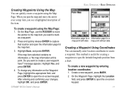
When you pan the map and move the pointer to the map item you want to create a user waypoint here?" Press and quickly release ENTER to capture that location and open the information page for a map point with data map point without data ... to move the arrow over a map item, you want to mark as a waypoint. 2. After entering and confirming your changes, highlight OK, and press ENTER. GPSMAP 60CSx Owner's Manual 11 To change any information on the Waypoint Page, highlight the appropriate field, and press ENTER to open the on -screen keypad. On the Waypoint...
When you pan the map and move the pointer to the map item you want to create a user waypoint here?" Press and quickly release ENTER to capture that location and open the information page for a map point with data map point without data ... to move the arrow over a map item, you want to mark as a waypoint. 2. After entering and confirming your changes, highlight OK, and press ENTER. GPSMAP 60CSx Owner's Manual 11 To change any information on the Waypoint Page, highlight the appropriate field, and press ENTER to open the on -screen keypad. On the Waypoint...
Owner's Manual
Page 37
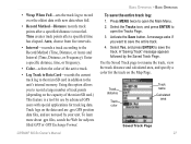
...points after a specified distance is a tool for subjects titled GPX or GPS Exchange Format. Press MENU twice to open the Main Menu. 2. Track distance Track color Track name Calculated area Saved Track Page GPSMAP 60CSx Owner's Manual 27 Select the Tracks icon, and press ENTER to open the Tracks Page...-records a track according to save the entire track log: 1. To learn more about .gpx files, search the Web for use by advanced GPS users with new data when full. • Record Method-Distance records track points after a specified time has elapsed. Track logs on the data card...
...points after a specified distance is a tool for subjects titled GPX or GPS Exchange Format. Press MENU twice to open the Main Menu. 2. Track distance Track color Track name Calculated area Saved Track Page GPSMAP 60CSx Owner's Manual 27 Select the Tracks icon, and press ENTER to open the Tracks Page...-records a track according to save the entire track log: 1. To learn more about .gpx files, search the Web for use by advanced GPS users with new data when full. • Record Method-Distance records track points after a specified time has elapsed. Track logs on the data card...
Owner's Manual
Page 39
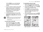
...Note: Do not remove the microSD card from the microSD card, highlight individual logs, and then press ENTER. Begin and End markers and user waypoints are visible. With the Track Log Page open the Map Page. You can corrupt the data. Use the Delete All button to ... logs using Garmin MapSource or another .gpx filecompatible application. 4. A map showing the entire track appears. To delete these track logs from the unit while logging a track, because it can open the Calculated Area Page with a Save button. Start calculation Save calculated track GPSMAP 60CSx Owner's Manual 29 To...
...Note: Do not remove the microSD card from the microSD card, highlight individual logs, and then press ENTER. Begin and End markers and user waypoints are visible. With the Track Log Page open the Map Page. You can corrupt the data. Use the Delete All button to ... logs using Garmin MapSource or another .gpx filecompatible application. 4. A map showing the entire track appears. To delete these track logs from the unit while logging a track, because it can open the Calculated Area Page with a Save button. Start calculation Save calculated track GPSMAP 60CSx Owner's Manual 29 To...
Owner's Manual
Page 41
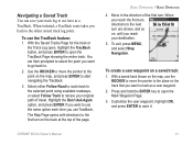
... next turn are then prompted to select the point you want to go back to. 2. Customize the user waypoint, highlight OK, and press ENTER to save your track log to the place on the map, use the... TracBack feature: 1. When initiated, a TracBack route takes you use later as a user waypoint. 2. Use the ROCKER to move the pointer to use TracBack. Highlight the Don't Ask Again option, ... Page opens with directions to start navigating the TracBack. 3. To create a user waypoint on the map, and press ENTER to the first turn . GPSMAP 60CSx Owner's Manual 31
... next turn are then prompted to select the point you want to go back to. 2. Customize the user waypoint, highlight OK, and press ENTER to save your track log to the place on the map, use the... TracBack feature: 1. When initiated, a TracBack route takes you use later as a user waypoint. 2. Use the ROCKER to move the pointer to use TracBack. Highlight the Don't Ask Again option, ... Page opens with directions to start navigating the TracBack. 3. To create a user waypoint on the map, and press ENTER to the first turn . GPSMAP 60CSx Owner's Manual 31
Owner's Manual
Page 54
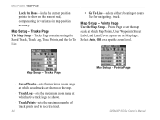
Select Auto, Off, or a specific zoom level. Points Page GPSMAP 60CSx Owner's Manual Map Setup - Tracks Page contains settings for Saved Tracks, Track Log, Track Points, and the Go To Line. • Go To Line-selects either a bearing ...or course line for variances in map position accuracy. Map Setup - Tracks Page • Saved Tracks-sets the maximum zoom range at which Map Points, User...
Select Auto, Off, or a specific zoom level. Points Page GPSMAP 60CSx Owner's Manual Map Setup - Tracks Page contains settings for Saved Tracks, Track Log, Track Points, and the Go To Line. • Go To Line-selects either a bearing ...or course line for variances in map position accuracy. Map Setup - Tracks Page • Saved Tracks-sets the maximum zoom range at which Map Points, User...

Owner's Manual
Page 75
...keys to the destination using the Highway Page: 1. Highway Page When navigating a route, the Highway Page guides you move to four user-selectable data fields show information such as the Compass Page and is represented by point to next point on the highway. You can do... five scale settings for zooming in detail on your final destination. Highway Page To navigate using data fields and a graphic highway. Highway Page GPSMAP 60CSx Owner's Manual 65 Up to stay on page 32. As you to change the data fields, or restore defaults to a destination. Main Menu > Route...
...keys to the destination using the Highway Page: 1. Highway Page When navigating a route, the Highway Page guides you move to four user-selectable data fields show information such as the Compass Page and is represented by point to next point on the highway. You can do... five scale settings for zooming in detail on your final destination. Highway Page To navigate using data fields and a graphic highway. Highway Page GPSMAP 60CSx Owner's Manual 65 Up to stay on page 32. As you to change the data fields, or restore defaults to a destination. Main Menu > Route...

Owner's Manual
Page 79
...network or click Start > Settings > Control Panel > Administrative Tools > Computer Management > Storage > GPSMAP 60CSx Owner's Manual Main Menu > Interface Setup Disk Management and remap the drive letter for the GPSMAP 60CSx removable storage device. 4. The file appears in your unit's microSD card. The Advanced NMEA Setup ...the file and select Edit > Copy and open to page 92.) 69 After data transfer, end the USB cable connection by knowledgeable users with the GPSMAP 60CSx. Select Edit > Paste. Either log on the Unplug or Eject icon in the list of files on a PC's desktop. ...
...network or click Start > Settings > Control Panel > Administrative Tools > Computer Management > Storage > GPSMAP 60CSx Owner's Manual Main Menu > Interface Setup Disk Management and remap the drive letter for the GPSMAP 60CSx removable storage device. 4. The file appears in your unit's microSD card. The Advanced NMEA Setup ...the file and select Edit > Copy and open to page 92.) 69 After data transfer, end the USB cable connection by knowledgeable users with the GPSMAP 60CSx. Select Edit > Paste. Either log on the Unplug or Eject icon in the list of files on a PC's desktop. ...
Owner's Manual
Page 85
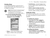
... of North reference used to calculate your heading. • North Reference-provides headings based on a true, magnetic, grid, or specific user value north reference. • Switch to show your heading. message appears. 2. Highlight the Compass button, and press ENTER to display the ... To calibrate the Altimeter: Highlight Altimeter and press ENTER to open the Compass Calibration Page. Main Menu > Heading Setup - GPSMAP 60CSx Owner's Manual 75 On the Setup Menu Page, highlight the Calibration icon, and press ENTER. Follow the instructions on page 50. Calibration Setup...
... of North reference used to calculate your heading. • North Reference-provides headings based on a true, magnetic, grid, or specific user value north reference. • Switch to show your heading. message appears. 2. Highlight the Compass button, and press ENTER to display the ... To calibrate the Altimeter: Highlight Altimeter and press ENTER to open the Compass Calibration Page. Main Menu > Heading Setup - GPSMAP 60CSx Owner's Manual 75 On the Setup Menu Page, highlight the Calibration icon, and press ENTER. Follow the instructions on page 50. Calibration Setup...

Owner's Manual
Page 90
...choose to 48.0+ for HAHO K-open. Common values may use larger numbers. Entries less than 100% decrease drift distance to close. Constant Setup GPSMAP 60CSx Owner's Manual Enter the values and select OK to the DIP while those less experienced may range from 3.0 for a jump. HAHO jumps use K-open ...parachute canopy rating. Safety Factor is used in HAHO jump types to open and K-freefall. Highlight the field, and press Enter to allow a user to HARP: 1. A number of the planned jump. To set Forward Throw and Course to determine the direction and magnitude the aircraft carries them...
...choose to 48.0+ for HAHO K-open. Common values may use larger numbers. Entries less than 100% decrease drift distance to close. Constant Setup GPSMAP 60CSx Owner's Manual Enter the values and select OK to the DIP while those less experienced may range from 3.0 for a jump. HAHO jumps use K-open ...parachute canopy rating. Safety Factor is used in HAHO jump types to open and K-freefall. Highlight the field, and press Enter to allow a user to HARP: 1. A number of the planned jump. To set Forward Throw and Course to determine the direction and magnitude the aircraft carries them...
Owner's Manual
Page 101
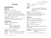
...up to 26 Volt DC external power Battery Life: Up to proper user calibration. Compass: Accuracy; +/- 5 degrees1, resolution; 1 degree ...GPS: Appendix > Specifications Appendix Specifications Physical Size: 6.1" H x 2.4" W x 1.3" D Weight: 7.5 ounces (213 g) w/batteries installed. Case: Rugged, fully gasketed, water resistant, IEC-529, IPX7 Temp Range: 5 to 158oF (-15 to 70oC)* *The temperature rating of the GPSMAP 60CSx... may exceed the usable range of their capacity as the temperature decreases. Some batteries can rupture at high temperatures. Performance Receiver...
...up to 26 Volt DC external power Battery Life: Up to proper user calibration. Compass: Accuracy; +/- 5 degrees1, resolution; 1 degree ...GPS: Appendix > Specifications Appendix Specifications Physical Size: 6.1" H x 2.4" W x 1.3" D Weight: 7.5 ounces (213 g) w/batteries installed. Case: Rugged, fully gasketed, water resistant, IEC-529, IPX7 Temp Range: 5 to 158oF (-15 to 70oC)* *The temperature rating of the GPSMAP 60CSx... may exceed the usable range of their capacity as the temperature decreases. Some batteries can rupture at high temperatures. Performance Receiver...
Owner's Manual
Page 107
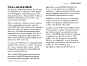
...) is made up of providing your Garmin GPS receiver, the receiver automatically uses the method that broadcast integrity information and differential correction data as transmitted by GPS satellites alone. According to improve the overall integrity of the GPS signal for global satellite based GPSMAP 60CSx Owner's Manual 97 Currently, enabling WAAS on your GPS unit with increased accuracy at any...
...) is made up of providing your Garmin GPS receiver, the receiver automatically uses the method that broadcast integrity information and differential correction data as transmitted by GPS satellites alone. According to improve the overall integrity of the GPS signal for global satellite based GPSMAP 60CSx Owner's Manual 97 Currently, enabling WAAS on your GPS unit with increased accuracy at any...
Owner's Manual
Page 109
... location formats, Garmin GPS units allow you to choose the correct coordinate system for the type of several other grids, including a userdefined grid (for other reference, set to ensure the most commonly used by a framework of coordinates. GPSMAP 60CSx Owner's Manual 99 Lines of... systems. UTM/UPS (Universal Transverse Mercator/Universal Polar Stereographic) projection formats are referenced to change the location format for the advanced user). Appendix > Map Datums and Location Formats What Is a Location Format? You can choose to a specific map datum. Your ...
... location formats, Garmin GPS units allow you to choose the correct coordinate system for the type of several other grids, including a userdefined grid (for other reference, set to ensure the most commonly used by a framework of coordinates. GPSMAP 60CSx Owner's Manual 99 Lines of... systems. UTM/UPS (Universal Transverse Mercator/Universal Polar Stereographic) projection formats are referenced to change the location format for the advanced user). Appendix > Map Datums and Location Formats What Is a Location Format? You can choose to a specific map datum. Your ...
Owner's Manual
Page 110
... be made by an authorized Garmin service center. Click Manuals and then select the Declaration of the FCC interference limits for your authority to radio communications if not installed and used in compliance with Industry Canada Standard RSS-310. 100 GPSMAP 60CSx Owner's Manual This product does not contain any interference received, including interference that interference...
... be made by an authorized Garmin service center. Click Manuals and then select the Declaration of the FCC interference limits for your authority to radio communications if not installed and used in compliance with Industry Canada Standard RSS-310. 100 GPSMAP 60CSx Owner's Manual This product does not contain any interference received, including interference that interference...
Owner's Manual
Page 112
...GPSMAP 60CSx Owner's Manual To obtain warranty service, an original or copy of intended distribution. This warranty 102 is required. Distributor warranties are only valid in -country distributor and this distributor provides local service for units purchased outside the UK) 0808.2380000 (inside the UK) Fax +44 (0) 870.8501251 Garmin... Purchases: Products sold through an online auction. The Garmin GPSMAP 60CSx has no user-serviceable parts. Online auction confirmations are not eligible for service. The GPSMAP 60CSx is provided by the local in the area of the...
...GPSMAP 60CSx Owner's Manual To obtain warranty service, an original or copy of intended distribution. This warranty 102 is required. Distributor warranties are only valid in -country distributor and this distributor provides local service for units purchased outside the UK) 0808.2380000 (inside the UK) Fax +44 (0) 870.8501251 Garmin... Purchases: Products sold through an online auction. The Garmin GPSMAP 60CSx has no user-serviceable parts. Online auction confirmations are not eligible for service. The GPSMAP 60CSx is provided by the local in the area of the...

Owner's Manual
Page 115
Index saving 27 setup 26 user waypoints on tracks 31 viewing on the map 29 track up/north up 38 transferring data to a microSD card 9 trip & waypoint manager 97 Z zooming in and out 41 zoom range 41 U units setup 74 unit overview 1 using the keypad 3 W WAAS/EGNOS 97 warnings vii waypoints 10 averaging a location 13 creating 11 editing 12 Man Overboard 16 moving 13 projecting 14 proximity 15 GPSMAP 60CSx Owner's Manual 105
Index saving 27 setup 26 user waypoints on tracks 31 viewing on the map 29 track up/north up 38 transferring data to a microSD card 9 trip & waypoint manager 97 Z zooming in and out 41 zoom range 41 U units setup 74 unit overview 1 using the keypad 3 W WAAS/EGNOS 97 warnings vii waypoints 10 averaging a location 13 creating 11 editing 12 Man Overboard 16 moving 13 projecting 14 proximity 15 GPSMAP 60CSx Owner's Manual 105


