Installation Instructions
Page 8
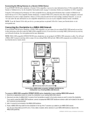
... your boat to share information with your device, you can receive sonar information from a CANet-compatible Garmin Sounder or Fishfinder device. Connecting the Chartplotter to a NMEA 2000 Network If your GPSMAP 400/500 series chartplotter is NMEA 2000-compatible, you must purchase an optional CANet ... a NMEA 2000 drop cable from your local Garmin dealer or marine dealer. If you disconnected. 3. If more information. Connecting the Wiring Harness to a Garmin CANet Device If your GPSMAP 400/500 series chartplotter is Garmin CANet-compatible, it to an existing NMEA 2000...
... your boat to share information with your device, you can receive sonar information from a CANet-compatible Garmin Sounder or Fishfinder device. Connecting the Chartplotter to a NMEA 2000 Network If your GPSMAP 400/500 series chartplotter is NMEA 2000-compatible, you must purchase an optional CANet ... a NMEA 2000 drop cable from your local Garmin dealer or marine dealer. If you disconnected. 3. If more information. Connecting the Wiring Harness to a Garmin CANet Device If your GPSMAP 400/500 series chartplotter is Garmin CANet-compatible, it to an existing NMEA 2000...
Owner's Manual
Page 63
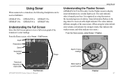
It is organized as fishfinders: GPSMAP 431s GPSMAP 441s GPSMAP 531s GPSMAP 536s GPSMAP 541s GPSMAP 546s Understanding the Full Screen Select the Full ...return.) From the Home screen, select Sonar > Flasher. Using Sonar When connected to a transducer, the following chartplotters can be used as a ring that starts at the depth indicated. From the Home screen, select Sonar > ...sonar readings Transducer frequency or beam width Full Screen GPSMAP 400/500 Series Owner's Manual Water depth at current location Flasher 57 The scale indicates what is received at the top and progresses clockwise.
It is organized as fishfinders: GPSMAP 431s GPSMAP 441s GPSMAP 531s GPSMAP 536s GPSMAP 541s GPSMAP 546s Understanding the Full Screen Select the Full ...return.) From the Home screen, select Sonar > Flasher. Using Sonar When connected to a transducer, the following chartplotters can be used as a ring that starts at the depth indicated. From the Home screen, select Sonar > ...sonar readings Transducer frequency or beam width Full Screen GPSMAP 400/500 Series Owner's Manual Water depth at current location Flasher 57 The scale indicates what is received at the top and progresses clockwise.
Owner's Manual
Page 56
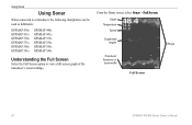
Depth Temperature Speed Suspended targets Transducer frequency or beam width Full Screen Range 50 GPSMAP 400/500 Series Owner's Manual Using Sonar Using Sonar When connected to a transducer, the following chartplotters can be used as fishfinders: GPSMAP 430s GPSMAP 431s GPSMAP 530s GPSMAP 531s GPSMAP 540s GPSMAP 541s GPSMAP 440s GPSMAP 441s GPSMAP 535s GPSMAP 536s GPSMAP 545s GPSMAP 546s Understanding the Full Screen Select the Full Screen option to view a full-screen graph of the transducer's sonar readings. From the Home screen, select Sonar > Full Screen.
Depth Temperature Speed Suspended targets Transducer frequency or beam width Full Screen Range 50 GPSMAP 400/500 Series Owner's Manual Using Sonar Using Sonar When connected to a transducer, the following chartplotters can be used as fishfinders: GPSMAP 430s GPSMAP 431s GPSMAP 530s GPSMAP 531s GPSMAP 540s GPSMAP 541s GPSMAP 440s GPSMAP 441s GPSMAP 535s GPSMAP 536s GPSMAP 545s GPSMAP 546s Understanding the Full Screen Select the Full Screen option to view a full-screen graph of the transducer's sonar readings. From the Home screen, select Sonar > Full Screen.

