Installation Instructions
Page 3
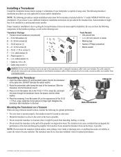
...contain installation instructions for the transducer included with the "s" model GPSMAP 400/500 series chartplotters. Some transducers might be spliced and connected to determine if your chartplotter is capable of the propeller on single-drive boats. The...in . (9.5 mm) wrench or socket E • Masking tape • Number 2 Phillips screwdriver F H • Marine sealant I - rubber washer (1) I Notice: Do not cut the transducer lead or any existing (Garmin or non-Garmin) transducer cables. Cable entry cover (1) A B C D J Tools Needed • Drill and drill bits G •...
...contain installation instructions for the transducer included with the "s" model GPSMAP 400/500 series chartplotters. Some transducers might be spliced and connected to determine if your chartplotter is capable of the propeller on single-drive boats. The...in . (9.5 mm) wrench or socket E • Masking tape • Number 2 Phillips screwdriver F H • Marine sealant I - rubber washer (1) I Notice: Do not cut the transducer lead or any existing (Garmin or non-Garmin) transducer cables. Cable entry cover (1) A B C D J Tools Needed • Drill and drill bits G •...
Installation Instructions
Page 4
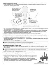
.... Drill 5/32 in. (4 mm) pilot holes approximately 1 in . (9.5 mm) on both sides of the transom. 6. Apply marine sealant to the GPSMAP 400/500 series chartplotter. Attach the cable clamp using one third of the distance between the transducer and the top of the mount. Repeat steps 5 and... Test the transducer installation after you pull it is snug but not tight. (The cable tie clicks when you complete the GPSMAP 400/500 series chartplotter installation. With the front of the transducer pointed away from the trolling motor propeller, place the transducer assembly against the motor ...
.... Drill 5/32 in. (4 mm) pilot holes approximately 1 in . (9.5 mm) on both sides of the transom. 6. Apply marine sealant to the GPSMAP 400/500 series chartplotter. Attach the cable clamp using one third of the distance between the transducer and the top of the mount. Repeat steps 5 and... Test the transducer installation after you pull it is snug but not tight. (The cable tie clicks when you complete the GPSMAP 400/500 series chartplotter installation. With the front of the transducer pointed away from the trolling motor propeller, place the transducer assembly against the motor ...
Installation Instructions
Page 8
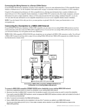
...use a drop cable up to two CANet compatible Garmin chartplotters. Contact your existing NMEA 2000 network. 2. Connecting the Chartplotter to a NMEA 2000 Network If your GPSMAP 400/500 series chartplotter is Garmin CANet-compatible, it can receive sonar information from the backbone nearest to the location...view and control the same information on your local Garmin dealer or marine dealer. NMEA 2000 components are not packaged with NMEA 2000 connectors or cables. Disconnect one . NMEA 2000compatible GPSMAP 400/500 series chartplotter NMEA 2000 device (not included) T-connector (...
...use a drop cable up to two CANet compatible Garmin chartplotters. Contact your existing NMEA 2000 network. 2. Connecting the Chartplotter to a NMEA 2000 Network If your GPSMAP 400/500 series chartplotter is Garmin CANet-compatible, it can receive sonar information from the backbone nearest to the location...view and control the same information on your local Garmin dealer or marine dealer. NMEA 2000 components are not packaged with NMEA 2000 connectors or cables. Disconnect one . NMEA 2000compatible GPSMAP 400/500 series chartplotter NMEA 2000 device (not included) T-connector (...
Installation Instructions
Page 11
... Data Compatible GPSMAP 400/500 series chartplotters are supported by the GPSMAP 525s/526s/535s/536s/545s/546s/555s/556s units only.) Dual Frequency, 500 W (RMS), 4,000 W (peak to peak); Dual Beam, 400 W (RMS), 3,200 W (peak to NMEA 2000-Compatible Chartplotters): Receive 059392 059904 ... complete information about National Marine Electronics Association (NMEA) format and sentences from: NMEA Seven Riggs Avenue Severna Park, MD 21146 USA www.nmea.org GPSMAP 400/500 Series Installation Instructions 11 Command/Request/Acknowledge Group Function Transmit/Receive PGN List Group Function ...
... Data Compatible GPSMAP 400/500 series chartplotters are supported by the GPSMAP 525s/526s/535s/536s/545s/546s/555s/556s units only.) Dual Frequency, 500 W (RMS), 4,000 W (peak to peak); Dual Beam, 400 W (RMS), 3,200 W (peak to NMEA 2000-Compatible Chartplotters): Receive 059392 059904 ... complete information about National Marine Electronics Association (NMEA) format and sentences from: NMEA Seven Riggs Avenue Severna Park, MD 21146 USA www.nmea.org GPSMAP 400/500 Series Installation Instructions 11 Command/Request/Acknowledge Group Function Transmit/Receive PGN List Group Function ...

Owner's Manual
Page 14
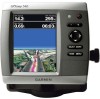
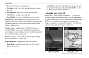
...BlueChart g2 Vision Mariner's Eye 3D is more detailed than the preloaded data. Your boat Exposed wreck Light Exposed rock Tide station Beacon Marina services Zoom scale Navigation Chart with enhanced bottom contours and without navigational data. Using Charts Using Charts Your chartplotter has a worldwide... aid. • Split Navigation Chart-displays two different zoom levels of the chart with g2 Vision GPSMAP 400/500 Series Owner's Manual Fishing charts, Fish Eye 3D, and Mariner's Eye 3D views are available when using optional BlueChart g2 Vision preprogrammed SD cards. • Fishing...
...BlueChart g2 Vision Mariner's Eye 3D is more detailed than the preloaded data. Your boat Exposed wreck Light Exposed rock Tide station Beacon Marina services Zoom scale Navigation Chart with enhanced bottom contours and without navigational data. Using Charts Using Charts Your chartplotter has a worldwide... aid. • Split Navigation Chart-displays two different zoom levels of the chart with g2 Vision GPSMAP 400/500 Series Owner's Manual Fishing charts, Fish Eye 3D, and Mariner's Eye 3D views are available when using optional BlueChart g2 Vision preprogrammed SD cards. • Fishing...
Owner's Manual
Page 22
...of tracks that have an XM subscription.) See page 60 for additional information. Other Vessels-view information about other vessels. Mariner's Eye 3D Navigation Chart 16 GPSMAP 400/500 Series Owner's Manual Data Bars (page 9)-show or hide cruising, navigation, fishing, fuel, sailing numbers, ...off. (The Weather feature is only available if the chartplotter is beneficial when trying to identify entry and exit routes in unfamiliar harbors or anchorages. Using Mariner's Eye 3D A BlueChart g2 Vision SD card offers Mariner's Eye 3D, which provides a detailed three-dimensional view...
...of tracks that have an XM subscription.) See page 60 for additional information. Other Vessels-view information about other vessels. Mariner's Eye 3D Navigation Chart 16 GPSMAP 400/500 Series Owner's Manual Data Bars (page 9)-show or hide cruising, navigation, fishing, fuel, sailing numbers, ...off. (The Weather feature is only available if the chartplotter is beneficial when trying to identify entry and exit routes in unfamiliar harbors or anchorages. Using Mariner's Eye 3D A BlueChart g2 Vision SD card offers Mariner's Eye 3D, which provides a detailed three-dimensional view...

Owner's Manual
Page 23
...to your boat and lower to view details about navaids such as seen from the water. Mariner's Eye 3D Settings To access additional settings or options from the boat. The On setting ... see "Navigation Chart Menu" on or off . (The Weather feature is only available if the chartplotter is highlighted. 2. Press SELECT to the water. Using Charts Style-Selects how chart data is displayed ... of the screen. When the cursor is very shallow water. To customize the appearance of the Mariner's Eye 3D screen, select MENU > Chart Appearance. The Off setting shows the land as beacons...
...to your boat and lower to view details about navaids such as seen from the water. Mariner's Eye 3D Settings To access additional settings or options from the boat. The On setting ... see "Navigation Chart Menu" on or off . (The Weather feature is only available if the chartplotter is highlighted. 2. Press SELECT to the water. Using Charts Style-Selects how chart data is displayed ... of the screen. When the cursor is very shallow water. To customize the appearance of the Mariner's Eye 3D screen, select MENU > Chart Appearance. The Off setting shows the land as beacons...
Owner's Manual
Page 53
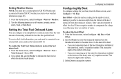
...must have a subscription to XM WX Weather and a connected Garmin XM WX weather receiver to the water line (transducer installed on or off: marine, tornado, severe storm, flood, or flash flood. Select Done to offset for a keel. GPSMAP 400/500 Series Owner's Manual 47 If you select On,...the transducer location. Setting Weather Alarms Note: You must be connected to indicate the fuel level at the surface. 3. Configuring the Chartplotter Configuring My Boat To configure settings for a large vessel that may draw several feet of from the transducer location to the water ...
...must have a subscription to XM WX Weather and a connected Garmin XM WX weather receiver to the water line (transducer installed on or off: marine, tornado, severe storm, flood, or flash flood. Select Done to offset for a keel. GPSMAP 400/500 Series Owner's Manual 47 If you select On,...the transducer location. Setting Weather Alarms Note: You must be connected to indicate the fuel level at the surface. 3. Configuring the Chartplotter Configuring My Boat To configure settings for a large vessel that may draw several feet of from the transducer location to the water ...


