
Owner's Manual
Page 5
...DSC 55 Using the Chartplotter with a VHF Radio 55 Adding a DSC Contact 56 Viewing the DSC List 56 Receiving Distress Calls 56 Man-Overboard Distress Calls Initiated from a VHF Radio........ 57 Man-Overboard Distress Calls Initiated from ...WX Weather and Audio 60 Using XM WX Weather 60 Viewing NEXRAD Precipitation Information 61 Viewing Forecast Information 64 Viewing Fishing Information 65 Viewing Sea Conditions 66 Viewing Visibility Information 67 Using XM Audio 68 Appendix ... Agreement 76 XM Satellite Radio Service Agreement 76 Index 77 GPSMAP 400/500 Series Owner's Manual iii
...DSC 55 Using the Chartplotter with a VHF Radio 55 Adding a DSC Contact 56 Viewing the DSC List 56 Receiving Distress Calls 56 Man-Overboard Distress Calls Initiated from a VHF Radio........ 57 Man-Overboard Distress Calls Initiated from ...WX Weather and Audio 60 Using XM WX Weather 60 Viewing NEXRAD Precipitation Information 61 Viewing Forecast Information 64 Viewing Fishing Information 65 Viewing Sea Conditions 66 Viewing Visibility Information 67 Using XM Audio 68 Appendix ... Agreement 76 XM Satellite Radio Service Agreement 76 Index 77 GPSMAP 400/500 Series Owner's Manual iii
Owner's Manual
Page 70
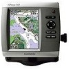
... from a low-pressure center in any horizontal direction results in North America. From the Home screen, select Information > Weather > Forecast. 2. GPSMAP 400/500 Series Owner's Manual Press right on the Rocker to view forecasts for another time period: 1. To view forecast information for the next... area where the measured pressure is lowest relative to pan the screen until the screen displays the location you want. 64 Indicates a low-pressure center. Winds flow clockwise around lowpressure centers in decreased pressure. This feature also shows pressure centers.
... from a low-pressure center in any horizontal direction results in North America. From the Home screen, select Information > Weather > Forecast. 2. GPSMAP 400/500 Series Owner's Manual Press right on the Rocker to view forecasts for another time period: 1. To view forecast information for the next... area where the measured pressure is lowest relative to pan the screen until the screen displays the location you want. 64 Indicates a low-pressure center. Winds flow clockwise around lowpressure centers in decreased pressure. This feature also shows pressure centers.

Owner's Manual
Page 83
...clock 46 collision 26, 49 deep water 46 fish 46 fuel 47 GPS accuracy 46 navigation 45 safe-zone 49 shallow water 46 sonar 46...using 21 chart data 10 charts detail 14 fish eye 3D 18 fishing 19 mariner's eye 3D 16 navigation 8 settings 12 cleaning the unit 74 Clear User Data...17 Color Scheme 53 Communications 44 Compass 34 compass rose 12 contact information, Garmin iv course up 13 current stations 36 customizing chart settings 12 D dashboard ... information 64 frequency 54 Fuel Capacity 48 fuel gauges 35 full screen, sonar 50 fuse 70 G gain 54 Garmin Data Transfer 44 gauges, fuel 35 go to 27 GPS 5, ...
...clock 46 collision 26, 49 deep water 46 fish 46 fuel 47 GPS accuracy 46 navigation 45 safe-zone 49 shallow water 46 sonar 46...using 21 chart data 10 charts detail 14 fish eye 3D 18 fishing 19 mariner's eye 3D 16 navigation 8 settings 12 cleaning the unit 74 Clear User Data...17 Color Scheme 53 Communications 44 Compass 34 compass rose 12 contact information, Garmin iv course up 13 current stations 36 customizing chart settings 12 D dashboard ... information 64 frequency 54 Fuel Capacity 48 fuel gauges 35 full screen, sonar 50 fuse 70 G gain 54 Garmin Data Transfer 44 gauges, fuel 35 go to 27 GPS 5, ...
Owner's Manual
Page 84
... number 6 K keel offset 47 keypad 5 L Lane Width 16, 18 Language 42 lightning information 62 low-pressure center 64 M man overboard 29, 57 map datum 42 MapSource data 37 Mariner's Eye 3D AIS 26 MARPA 26 mariner's eye 3D colors 17 mark current location 29 MARPA threats 26 MENU key 5 messages 71 78 move... Card 38, 39, 41 screenshots 74 scroll speed 52 SD cards inserting 6 removing 6 sea conditions 66 SELECT key 5 Serial Port setup 44 Service Points 12 GPSMAP 400/500 Series Owner's Manual
... number 6 K keel offset 47 keypad 5 L Lane Width 16, 18 Language 42 lightning information 62 low-pressure center 64 M man overboard 29, 57 map datum 42 MapSource data 37 Mariner's Eye 3D AIS 26 MARPA 26 mariner's eye 3D colors 17 mark current location 29 MARPA threats 26 MENU key 5 messages 71 78 move... Card 38, 39, 41 screenshots 74 scroll speed 52 SD cards inserting 6 removing 6 sea conditions 66 SELECT key 5 Serial Port setup 44 Service Points 12 GPSMAP 400/500 Series Owner's Manual