
Installation Instructions
Page 10
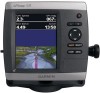
...Differential-ready 12 parallel channel WAAS-capable receiver GPSMAP 421/431/441/451 (s) GPSMAP 521/531/541/551 (s): High-sensitivity 14 parallel channel WAAS-capable receiver. diagonal (12.7 cm), Full VGA display with a clear view of the boat. Update Rate: 1/second, continuous GPS Accuracy: Position: Begin testing the installation... (s): High-sensitivity 12 parallel channel WAAS-capable receiver. Return the boat to 55ºC) Compass-Safe Distances: Model Number GPSMAP 526/536/546/556 GPSMAP 421/431/441/451 GPSMAP 521/531/541/551 GPSMAP 420/430/440/450 GPSMAP 520/530/540/550/525/535/545/555...
...Differential-ready 12 parallel channel WAAS-capable receiver GPSMAP 421/431/441/451 (s) GPSMAP 521/531/541/551 (s): High-sensitivity 14 parallel channel WAAS-capable receiver. diagonal (12.7 cm), Full VGA display with a clear view of the boat. Update Rate: 1/second, continuous GPS Accuracy: Position: Begin testing the installation... (s): High-sensitivity 12 parallel channel WAAS-capable receiver. Return the boat to 55ºC) Compass-Safe Distances: Model Number GPSMAP 526/536/546/556 GPSMAP 421/431/441/451 GPSMAP 521/531/541/551 GPSMAP 420/430/440/450 GPSMAP 520/530/540/550/525/535/545/555...
Installation Instructions
Page 11
...water conditions. Dynamic Fluid Level Speed - Dual Beam, 400 W (RMS), 3,200 W (peak to NMEA 2000-Compatible Chartplotters): Receive 059392 059904 060928 126208 126464 126996 127250 127488 127489 127505 128259 128267 129038 129039 129040 129794 129799 129808 130306 130310 130311 130312 130313 ISO...Address Claim NMEA - Rapid Update Engine Parameters - Water Referenced Water Depth Position, Rapid Update COG/SOG Rapid Update GNSS - Route/WP information GNSS DOPs GNSS Sats in View Wind Data Compatible GPSMAP 400/500 series chartplotters are supported by the GPSMAP 525s/526s/535s/536s/...
...water conditions. Dynamic Fluid Level Speed - Dual Beam, 400 W (RMS), 3,200 W (peak to NMEA 2000-Compatible Chartplotters): Receive 059392 059904 060928 126208 126464 126996 127250 127488 127489 127505 128259 128267 129038 129039 129040 129794 129799 129808 130306 130310 130311 130312 130313 ISO...Address Claim NMEA - Rapid Update Engine Parameters - Water Referenced Water Depth Position, Rapid Update COG/SOG Rapid Update GNSS - Route/WP information GNSS DOPs GNSS Sats in View Wind Data Compatible GPSMAP 400/500 series chartplotters are supported by the GPSMAP 525s/526s/535s/536s/...
Installation Instructions
Page 12
...) for any person or organization of Garmin. or its subsidiaries Garmin International, Inc. 1200 East 151st Street, Olathe, Kansas 66062, USA Garmin (Europe) Ltd. September 2009 © 2009 Garmin Ltd. Garmin®, the Garmin logo, GPSMAP®, and AutoLocate® are trademarks of the National Maritime ...or stored in this manual onto a hard drive or other Garmin products. Garmin reserves the right to make changes in Taiwan For the latest free software updates (excluding map data) throughout the life of Garmin Ltd. or its subsidiaries. These trademarks may be used ...
...) for any person or organization of Garmin. or its subsidiaries Garmin International, Inc. 1200 East 151st Street, Olathe, Kansas 66062, USA Garmin (Europe) Ltd. September 2009 © 2009 Garmin Ltd. Garmin®, the Garmin logo, GPSMAP®, and AutoLocate® are trademarks of the National Maritime ...or stored in this manual onto a hard drive or other Garmin products. Garmin reserves the right to make changes in Taiwan For the latest free software updates (excluding map data) throughout the life of Garmin Ltd. or its subsidiaries. These trademarks may be used ...

Owner's Manual
Page 2
... site (www.garmin.com) for any person or organization of this manual may not be used without notice. or its subsidiaries, registered in any storage medium, for current updates and supplemental information concerning the use and operation of XM Satellite Radio Inc. ...XM® and XM WX Satellite Weather® are registered trademarks of Garmin Ltd. Ultrascroll™, myGarmin™, and GFS™ are trademarks of the National Maritime Electronics Association. Garmin®, the Garmin logo, GPSMAP®, AutoLocate®, BlueChart®, g2 Vision®, and MapSource&#...
... site (www.garmin.com) for any person or organization of this manual may not be used without notice. or its subsidiaries, registered in any storage medium, for current updates and supplemental information concerning the use and operation of XM Satellite Radio Inc. ...XM® and XM WX Satellite Weather® are registered trademarks of Garmin Ltd. Ultrascroll™, myGarmin™, and GFS™ are trademarks of the National Maritime Electronics Association. Garmin®, the Garmin logo, GPSMAP®, AutoLocate®, BlueChart®, g2 Vision®, and MapSource&#...
Owner's Manual
Page 12
...off for use indoors or for practice. You may need this information to update the system software or to navigate using simulator mode because the GPS receiver is located on Simulator mode: 1. From the Home screen, select Configure ...GPSMAP 400/500 Series Owner's Manual Insert blank SD cards to transfer data such as waypoints, routes, and tracks to cancel. From the Home screen select Configure > System > Simulator. 2. Getting Started For more information about GPS, visit the Garmin Web site at www.garmin.com/aboutGPS. Using Simulator Mode Simulator mode turns the GPS receiver...
...off for use indoors or for practice. You may need this information to update the system software or to navigate using simulator mode because the GPS receiver is located on Simulator mode: 1. From the Home screen, select Configure ...GPSMAP 400/500 Series Owner's Manual Insert blank SD cards to transfer data such as waypoints, routes, and tracks to cancel. From the Home screen select Configure > System > Simulator. 2. Getting Started For more information about GPS, visit the Garmin Web site at www.garmin.com/aboutGPS. Using Simulator Mode Simulator mode turns the GPS receiver...

Owner's Manual
Page 13
...version of MapSource by clicking Help > Check for Software Updates, or check the Garmin Web site at www.garmin.com. Note: You must have an "s" series unit (such as a GPSMAP 441s) with a connected transducer or have a connection to a Garmin sounder via CANet to access all other vessels (page 34...). • Configure-access unit and system settings (page 41). Press HOME from MapSource®, update to the Home screen. • Charts-...
...version of MapSource by clicking Help > Check for Software Updates, or check the Garmin Web site at www.garmin.com. Note: You must have an "s" series unit (such as a GPSMAP 441s) with a connected transducer or have a connection to a Garmin sounder via CANet to access all other vessels (page 34...). • Configure-access unit and system settings (page 41). Press HOME from MapSource®, update to the Home screen. • Charts-...

Owner's Manual
Page 43
...to the most-current version by clicking Help > About MapSource. Current-station information is older than 6.12.2, update to and from the Navigation chart. Insert an SD card into an SD card reader that is attached to ...on the computer by clicking Help > Check for the selected station. To copy or merge MapSource data to the computer. 37 GPSMAP 400/500 Series Owner's Manual Viewing Information Viewing User Data To view user data, from a specific SD card. 2. Select ... allow it to view the Current Prediction Report for Software Updates, or check the Garmin Web site at www...
...to the most-current version by clicking Help > About MapSource. Current-station information is older than 6.12.2, update to and from the Navigation chart. Insert an SD card into an SD card reader that is attached to ...on the computer by clicking Help > Check for the selected station. To copy or merge MapSource data to the computer. 37 GPSMAP 400/500 Series Owner's Manual Viewing Information Viewing User Data To view user data, from a specific SD card. 2. Select ... allow it to view the Current Prediction Report for Software Updates, or check the Garmin Web site at www...
Owner's Manual
Page 67
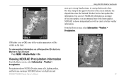
NEXRAD shows very light rain and GPSMAP 400/500 Series Owner's Manual 61 Viewing NEXRAD Precipitation Information From the Home screen, select Information > Weather > Precipitation. You can view NEXRAD information as an image of the latest update, or as an animated loop of the screen indicates the ...is shown independently or with a variety of other weather information. NEXRAD is set to strong thunderstorms in the upper-left corner of the latest updates. From the Home screen, select Information > Weather > Precipitation. Using XM WX Weather and Audio snow up to Off, none of the...
NEXRAD shows very light rain and GPSMAP 400/500 Series Owner's Manual 61 Viewing NEXRAD Precipitation Information From the Home screen, select Information > Weather > Precipitation. You can view NEXRAD information as an image of the latest update, or as an animated loop of the screen indicates the ...is shown independently or with a variety of other weather information. NEXRAD is set to strong thunderstorms in the upper-left corner of the latest updates. From the Home screen, select Information > Weather > Precipitation. Using XM WX Weather and Audio snow up to Off, none of the...
Owner's Manual
Page 68
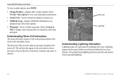
Understanding Storm Cell Information The storm cells show storms as well as an animated loop of the latest updates. • Waypoints-shows or hides waypoints. Each bar represents 15 minutes. Storm cell Lightning Understanding Lightning Information Lightning strikes are ...Change Weather-displays other weather options. The red bars that are represented by lightning bolt icons. Select Weather Subscription to -ground lightning. 62 GPSMAP 400/500 Series Owner's Manual Select Navigation Only to display only waypoints that appear in the cone indicate where the storm will most likely...
Understanding Storm Cell Information The storm cells show storms as well as an animated loop of the latest updates. • Waypoints-shows or hides waypoints. Each bar represents 15 minutes. Storm cell Lightning Understanding Lightning Information Lightning strikes are ...Change Weather-displays other weather options. The red bars that are represented by lightning bolt icons. Select Weather Subscription to -ground lightning. 62 GPSMAP 400/500 Series Owner's Manual Select Navigation Only to display only waypoints that appear in the cone indicate where the storm will most likely...
Owner's Manual
Page 75
...; 234 pixels. Temp. GPSMAP 536/536s GPSMAP 546/546s Update Rate: once per second GPSMAP 400/500 Series Owner's Manual 69 GPSMAP 530/531/540/541: 5.0 in . (95 cm) Performance Receiver: Differential-ready 12 parallel channel WAAS-capable receiver. diagonal (12.7 cm...12.7 cm), Full VGA display with adjustable brightness, 640 × 480 pixels, capable of 4,096 colors. GPSMAP 431/431s GPSMAP 441/441s GPSMAP 531/531s GPSMAP 541/541s High-sensitivity, 12 parallel channel, WAAS-capable receiver. Appendix Specifications Physical Specifications Size : 400 Series: W × H × D: 5.7 in. ×...
...; 234 pixels. Temp. GPSMAP 536/536s GPSMAP 546/546s Update Rate: once per second GPSMAP 400/500 Series Owner's Manual 69 GPSMAP 530/531/540/541: 5.0 in . (95 cm) Performance Receiver: Differential-ready 12 parallel channel WAAS-capable receiver. diagonal (12.7 cm...12.7 cm), Full VGA display with adjustable brightness, 640 × 480 pixels, capable of 4,096 colors. GPSMAP 431/431s GPSMAP 441/441s GPSMAP 531/531s GPSMAP 541/541s High-sensitivity, 12 parallel channel, WAAS-capable receiver. Appendix Specifications Physical Specifications Size : 400 Series: W × H × D: 5.7 in. ×...
Owner's Manual
Page 79
...full and track recording has been turned off. If the transducer cable is removed while the unit is full. GPSMAP 400/500 Series Owner's Manual 73 Route Full-you attempted to add more than 250 waypoints and was truncated to... cable was calculated but the starting and ending position moved due to have the unit serviced. Contact your dealer or Garmin Product Support to safe depth settings-the auto-guidance route was disconnected. Track Truncated-a complete uploaded track does not fit...log points were deleted to transfer user data without deleting old data to needs a software update.
...full and track recording has been turned off. If the transducer cable is removed while the unit is full. GPSMAP 400/500 Series Owner's Manual 73 Route Full-you attempted to add more than 250 waypoints and was truncated to... cable was calculated but the starting and ending position moved due to have the unit serviced. Contact your dealer or Garmin Product Support to safe depth settings-the auto-guidance route was disconnected. Track Truncated-a complete uploaded track does not fit...log points were deleted to transfer user data without deleting old data to needs a software update.
Owner's Manual
Page 88
For the latest free software updates (excluding map data) throughout the life of your Garmin products, visit the Garmin Web site at www.garmin.com. or its subsidiaries Garmin International, Inc. 1200 East 151st Street, Olathe, Kansas 66062, USA Garmin (Europe) Ltd. Liberty House, Hounsdown Business Park, Southampton, Hampshire, SO40 9LR UK Garmin Corporation No. 68, Jangshu 2nd Road, Sijhih, Taipei County, Taiwan www.garmin.com Part Number 190-01074-00 Rev. B Printed in Taiwan January 2010 © 2010 Garmin Ltd.
For the latest free software updates (excluding map data) throughout the life of your Garmin products, visit the Garmin Web site at www.garmin.com. or its subsidiaries Garmin International, Inc. 1200 East 151st Street, Olathe, Kansas 66062, USA Garmin (Europe) Ltd. Liberty House, Hounsdown Business Park, Southampton, Hampshire, SO40 9LR UK Garmin Corporation No. 68, Jangshu 2nd Road, Sijhih, Taipei County, Taiwan www.garmin.com Part Number 190-01074-00 Rev. B Printed in Taiwan January 2010 © 2010 Garmin Ltd.


