
Installation Instructions
Page 10
... (65) cm 30 in. (75 cm) 38 in. (95 cm) Performance Receiver: GPSMAP 420/430/440/450 (s) GPSMAP 520/530/540/550/525/535/545/555 (s): Differential-ready 12 parallel channel WAAS-capable receiver GPSMAP 421/431/441/451 (s) GPSMAP 521/531/541/551 (s): High-sensitivity 14 parallel channel WAAS-capable..., note the speed at or near the last location where you might take several adjustments to IEC 529 IPX7 standards. Update Rate: 1/second, continuous GPS Accuracy: Position: Placing the transducer too deep can adversely affect the performance of striking underwater objects. diagonal (12.7 cm...
... (65) cm 30 in. (75 cm) 38 in. (95 cm) Performance Receiver: GPSMAP 420/430/440/450 (s) GPSMAP 520/530/540/550/525/535/545/555 (s): Differential-ready 12 parallel channel WAAS-capable receiver GPSMAP 421/431/441/451 (s) GPSMAP 521/531/541/551 (s): High-sensitivity 14 parallel channel WAAS-capable..., note the speed at or near the last location where you might take several adjustments to IEC 529 IPX7 standards. Update Rate: 1/second, continuous GPS Accuracy: Position: Placing the transducer too deep can adversely affect the performance of striking underwater objects. diagonal (12.7 cm...
Installation Instructions
Page 11
... View Wind Data Compatible GPSMAP 400/500 series chartplotters are supported by the GPSMAP 525s/526s/535s/536s/545s/546s/555s/556s units only.) Dual Frequency, 500 W (RMS), 4,000 W (peak to peak); Command/Request/Acknowledge Group Function Transmit/Receive PGN List Group Function ... Update COG/SOG Rapid Update GNSS - Sonar Power: 1 kW Transducer, 1,000 W (RMS), 8,000 W (peak to peak); (1 kW transducers are NMEA 2000 certified. 130314 Actual Pressure NMEA 0183, Version 3.01 Sentences: SDDBT, SDDPT, SDMTW, SDVHW, SDWPL You can purchase complete information about National Marine ...
... View Wind Data Compatible GPSMAP 400/500 series chartplotters are supported by the GPSMAP 525s/526s/535s/536s/545s/546s/555s/556s units only.) Dual Frequency, 500 W (RMS), 4,000 W (peak to peak); Command/Request/Acknowledge Group Function Transmit/Receive PGN List Group Function ... Update COG/SOG Rapid Update GNSS - Sonar Power: 1 kW Transducer, 1,000 W (RMS), 8,000 W (peak to peak); (1 kW transducers are NMEA 2000 certified. 130314 Actual Pressure NMEA 0183, Version 3.01 Sentences: SDDBT, SDDPT, SDMTW, SDVHW, SDWPL You can purchase complete information about National Marine ...
Installation Instructions
Page 12
Garmin®, the Garmin logo, GPSMAP®, and AutoLocate® are registered trademarks of Garmin. or its subsidiaries, registered in the USA and other countries. Except as expressly provided herein, no part of this manual may not be...content without the express prior written consent of this document is strictly prohibited. For the latest free software updates (excluding map data) throughout the life of Garmin Ltd. Visit the Garmin Web site (www.garmin.com) for any revision hereto is subject to change without the express permission of the National Maritime ...
Garmin®, the Garmin logo, GPSMAP®, and AutoLocate® are registered trademarks of Garmin. or its subsidiaries, registered in the USA and other countries. Except as expressly provided herein, no part of this manual may not be...content without the express prior written consent of this document is strictly prohibited. For the latest free software updates (excluding map data) throughout the life of Garmin Ltd. Visit the Garmin Web site (www.garmin.com) for any revision hereto is subject to change without the express permission of the National Maritime ...

Owner's Manual
Page 2
...) 397.8200 or (800) 800.1020 Fax (913) 397.8282 Garmin (Europe) Ltd. November 2009 Part Number 190-01074-10 Rev. Garmin reserves the right to change without notice. Garmin®, the Garmin logo, GPSMAP®, BlueChart®, g2 Vision®, and MapSource® are registered... part of this and other countries. Windows® is strictly prohibited. Garmin hereby grants permission to download a single copy of this manual or any storage medium, for current updates and supplemental information concerning the use and operation of Microsoft Corporation in Taiwan...
...) 397.8200 or (800) 800.1020 Fax (913) 397.8282 Garmin (Europe) Ltd. November 2009 Part Number 190-01074-10 Rev. Garmin reserves the right to change without notice. Garmin®, the Garmin logo, GPSMAP®, BlueChart®, g2 Vision®, and MapSource® are registered... part of this and other countries. Windows® is strictly prohibited. Garmin hereby grants permission to download a single copy of this manual or any storage medium, for current updates and supplemental information concerning the use and operation of Microsoft Corporation in Taiwan...

Owner's Manual
Page 12
...update...GPSMAP 400/500 Series Owner's Manual The unit reboots and prompts you have entered. 1. Any satellite signal-strength bars shown are only simulations and do not represent the strength of interest. Insert blank SD cards to transfer data such as waypoints, routes, and tracks to navigate using simulator mode because the GPS receiver... is located on Simulator mode: 1. Press the card in again and release it to adjust unit settings (page 3). Getting Started Using Simulator Mode Simulator mode turns the GPS receiver off . CAUTION: Do not try to another compatible Garmin...
...update...GPSMAP 400/500 Series Owner's Manual The unit reboots and prompts you have entered. 1. Any satellite signal-strength bars shown are only simulations and do not represent the strength of interest. Insert blank SD cards to transfer data such as waypoints, routes, and tracks to navigate using simulator mode because the GPS receiver... is located on Simulator mode: 1. Press the card in again and release it to adjust unit settings (page 3). Getting Started Using Simulator Mode Simulator mode turns the GPS receiver off . CAUTION: Do not try to another compatible Garmin...
Owner's Manual
Page 13
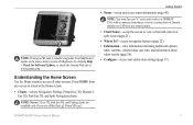
...waypoints from any screen to return to access all other vessels (page 30). • Configure-access unit and system settings (page 37). Note: Mariner's Eye 3D, Fish Eye 3D, and Fishing charts are available only if you use sonar features. • Chart/Sonar-set up the screen to... most-current version of MapSource by clicking Help > Check for Software Updates, or check the Garmin Web site at www.garmin.com. Note: You must have an "s" series unit (such as a GPSMAP 526s) with a connected transducer or have a connection to a Garmin sounder via CANet to use a BlueChart g2 Vision SD card. Press...
...waypoints from any screen to return to access all other vessels (page 30). • Configure-access unit and system settings (page 37). Note: Mariner's Eye 3D, Fish Eye 3D, and Fishing charts are available only if you use sonar features. • Chart/Sonar-set up the screen to... most-current version of MapSource by clicking Help > Check for Software Updates, or check the Garmin Web site at www.garmin.com. Note: You must have an "s" series unit (such as a GPSMAP 526s) with a connected transducer or have a connection to a Garmin sounder via CANet to use a BlueChart g2 Vision SD card. Press...

Owner's Manual
Page 39
...to the computer. This only needs to be done the first time you copy or merge MapSource data to and from a specific SD card. 2. GPSMAP 400/500 Series Owner's Manual 33 Select Show Report to view the Current Prediction Report for a different date. To copy or merge MapSource data to...1. Tracks-view a list of saved routes (page 25). If the version is attached to place a file on the computer by clicking Help > Check for Software Updates, or check the Garmin Web site at www .garmin.com. 3. This file provides information to MapSource to your MapSource version on the SD card.
...to the computer. This only needs to be done the first time you copy or merge MapSource data to and from a specific SD card. 2. GPSMAP 400/500 Series Owner's Manual 33 Select Show Report to view the Current Prediction Report for a different date. To copy or merge MapSource data to...1. Tracks-view a list of saved routes (page 25). If the version is attached to place a file on the computer by clicking Help > Check for Software Updates, or check the Garmin Web site at www .garmin.com. 3. This file provides information to MapSource to your MapSource version on the SD card.
Owner's Manual
Page 62
Update Rate: once per second GPS Accuracy: Position: Appendix Acquisition Times: (Average acquisition times for a stationary receiver with a clear view of the sky) GPSMAP 420/420s GPSMAP 520/520s GPSMAP 526/526s GPSMAP 550/550s GPSMAP 450/450s GPSMAP 525/525s GPSMAP 556/556s GPSMAP 555/555s Warm*: Approximately 15 seconds Cold**: Approximately 45 seconds GPSMAP 421/421s GPSMAP 451/451s GPSMAP 521/521s GPSMAP 551/551s Warm...
Update Rate: once per second GPS Accuracy: Position: Appendix Acquisition Times: (Average acquisition times for a stationary receiver with a clear view of the sky) GPSMAP 420/420s GPSMAP 520/520s GPSMAP 526/526s GPSMAP 550/550s GPSMAP 450/450s GPSMAP 525/525s GPSMAP 556/556s GPSMAP 555/555s Warm*: Approximately 15 seconds Cold**: Approximately 45 seconds GPSMAP 421/421s GPSMAP 451/451s GPSMAP 521/521s GPSMAP 551/551s Warm...

Owner's Manual
Page 65
...for some other reason. Shallow Water Alarm-the Shallow Water Alarm depth has been reached. GPSMAP 400/500 Series Owner's Manual Appendix Sonar Service Lost-the external sonar device you were ... Alarm-you attempted to add more track points, you are off . Contact your dealer or Garmin Product Support to "Stop When Full." No additional track log data can be stored without deleting...have the unit serviced. Sonar Service Incompatible-the external sonar device you need to needs a software update. Track Log Full-the track log is a bad cable or transducer, or the transducer cable ...
...for some other reason. Shallow Water Alarm-the Shallow Water Alarm depth has been reached. GPSMAP 400/500 Series Owner's Manual Appendix Sonar Service Lost-the external sonar device you were ... Alarm-you attempted to add more track points, you are off . Contact your dealer or Garmin Product Support to "Stop When Full." No additional track log data can be stored without deleting...have the unit serviced. Sonar Service Incompatible-the external sonar device you need to needs a software update. Track Log Full-the track log is a bad cable or transducer, or the transducer cable ...
Owner's Manual
Page 72
November 2009 © 2009 Garmin Ltd. B Printed in Taiwan Liberty House, Hounsdown Business Park, Southampton, Hampshire, SO40 9LR UK Garmin Corporation No. 68, Jangshu 2nd Road, Sijhih, Taipei County, Taiwan www.garmin.com Part Number 190-01074-10 Rev. or its subsidiaries Garmin International, Inc. 1200 East 151st Street, Olathe, Kansas 66062, USA Garmin (Europe) Ltd. For the latest free software updates (excluding map data) throughout the life of your Garmin products, visit the Garmin Web site at www.garmin.com.
November 2009 © 2009 Garmin Ltd. B Printed in Taiwan Liberty House, Hounsdown Business Park, Southampton, Hampshire, SO40 9LR UK Garmin Corporation No. 68, Jangshu 2nd Road, Sijhih, Taipei County, Taiwan www.garmin.com Part Number 190-01074-10 Rev. or its subsidiaries Garmin International, Inc. 1200 East 151st Street, Olathe, Kansas 66062, USA Garmin (Europe) Ltd. For the latest free software updates (excluding map data) throughout the life of your Garmin products, visit the Garmin Web site at www.garmin.com.

