Installation Instructions
Page 16
...GPSMAP 4000/5000 chartplotters are not linked. Port Receiving Port 1 Receiving Port 2 Receiving Port 3 Receiving Port 4 Transmitting Port 1 Transmitting Port 2 N/A N/A N/A N/A N/A N/A N/a Wire Function RX / A (+) RX / B (-) RX / A (+) RX / B (-) RX / A (+) RX / B (-) RX / A (+) rX / B (-) tX / A (+) tX / B (-) tX / A (+) tX / B (-) GPS...Color White Orange/White Brown Brown/White Violet Violet/White Black/White Red/White Gray Pink Blue Blue/White Green/White Green Yellow Orange Black Pin Number 1 2 5 6 9 10 11 12...Garmin proprietary sentences-PGRME, PGRMM, and PGRMZ. • The GPSMAP...
...GPSMAP 4000/5000 chartplotters are not linked. Port Receiving Port 1 Receiving Port 2 Receiving Port 3 Receiving Port 4 Transmitting Port 1 Transmitting Port 2 N/A N/A N/A N/A N/A N/A N/a Wire Function RX / A (+) RX / B (-) RX / A (+) RX / B (-) RX / A (+) RX / B (-) RX / A (+) rX / B (-) tX / A (+) tX / B (-) tX / A (+) tX / B (-) GPS...Color White Orange/White Brown Brown/White Violet Violet/White Black/White Red/White Gray Pink Blue Blue/White Green/White Green Yellow Orange Black Pin Number 1 2 5 6 9 10 11 12...Garmin proprietary sentences-PGRME, PGRMM, and PGRMZ. • The GPSMAP...
Owner's Manual
Page 4
... 2 Acquiring GPS Satellite Signals 3 Adjusting the Backlight 3 Adjusting the Color Mode 3 ...Inserting and Removing SD Cards 3 Restoring the Original Factory Settings 4 Viewing System Information 4 Using the Simulator Mode 4 Understanding the Home Screen 5 Using Charts 6 Using the Navigation Chart 6 Changing the Navigation Chart Settings 11 Using Perspective 3D 12 Using Radar Overlay 14 Using Tracks 14 Using BlueChart g2 Vision 15 Using Mariner...a Garmin Autopilot...Marine Network 43 Viewing Connected Garmin Marine...List 56 Receiving Distress Calls...Garmin 74 Declaration of...
... 2 Acquiring GPS Satellite Signals 3 Adjusting the Backlight 3 Adjusting the Color Mode 3 ...Inserting and Removing SD Cards 3 Restoring the Original Factory Settings 4 Viewing System Information 4 Using the Simulator Mode 4 Understanding the Home Screen 5 Using Charts 6 Using the Navigation Chart 6 Changing the Navigation Chart Settings 11 Using Perspective 3D 12 Using Radar Overlay 14 Using Tracks 14 Using BlueChart g2 Vision 15 Using Mariner...a Garmin Autopilot...Marine Network 43 Viewing Connected Garmin Marine...List 56 Receiving Distress Calls...Garmin 74 Declaration of...
Owner's Manual
Page 65
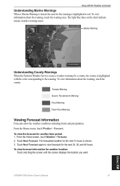
...Touch Next Forecast. Marine Warning Understanding County Warnings When the National Weather Service issues a weather warning for the next 12 hours is shown. 3. From the Home screen, touch Weather > Forecast. The forecasted weather for a county, the county is highlighted with the color corresponding to view ...forecasts for another time period: 1. To view information about the warning, touch the warning area. Touch Next Forecast again to the warning. To view forecast information for the next 24, 36, and 48 hours. GPSMAP 5000 Series ...
...Touch Next Forecast. Marine Warning Understanding County Warnings When the National Weather Service issues a weather warning for the next 12 hours is shown. 3. From the Home screen, touch Weather > Forecast. The forecasted weather for a county, the county is highlighted with the color corresponding to view ...forecasts for another time period: 1. To view information about the warning, touch the warning area. Touch Next Forecast again to the warning. To view forecast information for the next 24, 36, and 48 hours. GPSMAP 5000 Series ...
Owner's Manual
Page 80
... gauges 34 fuel 34 go to 23 GPS 36 performance 67 grid north 37 guide to 23 H hazard colors 17 heading 37 Heading Line 12 heading line 12 cruising screen 50 Head Up 11 high ... 12 look-ahd spd 50 low-pressure center 62 M Man Overboard 25 map datum 38 MapSource data 32 marine network 43 Mariner's Eye 3D 16 mariner's eye 6 mariner's eye 3D colors ...12 navigation 23 stop 24 navigation chart 6 nearby stations 30 network 43 New Waypoint 13 NMEA 69 0183 69 2000 69 NMEA 0183 38 NMEA 2000 38 north up 11 numbers viewing 30 O occluded front 62 orientation 50 other boats 34, 41 overlay numbers 53 GPSMAP...
... gauges 34 fuel 34 go to 23 GPS 36 performance 67 grid north 37 guide to 23 H hazard colors 17 heading 37 Heading Line 12 heading line 12 cruising screen 50 Head Up 11 high ... 12 look-ahd spd 50 low-pressure center 62 M Man Overboard 25 map datum 38 MapSource data 32 marine network 43 Mariner's Eye 3D 16 mariner's eye 6 mariner's eye 3D colors ...12 navigation 23 stop 24 navigation chart 6 nearby stations 30 network 43 New Waypoint 13 NMEA 69 0183 69 2000 69 NMEA 0183 38 NMEA 2000 38 north up 11 numbers viewing 30 O occluded front 62 orientation 50 other boats 34, 41 overlay numbers 53 GPSMAP...


