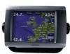
Owner's Manual
Page 4
... Turning the Chartplotter On 2 Turning the Chartplotter Off 2 Initializing Chartplotter Settings 2 Acquiring GPS Satellite Signals ...Using Mariner's Eye... a Garmin Autopilot ...Marine Network 43 Viewing Connected Garmin Marine...Chartplotter with a VHF Radio 55 Adding a DSC Contact 55 Viewing the DSC List 56 Receiving... Distress Calls 56 Man-Overboard Distress Calls Initiated from a VHF Radio 56 Man-Overboard Distress Calls Initiated from the Chartplotter...Touchscreen 68 Capturing Screenshots 68 NMEA 0183 and NMEA 2000 69 Messages and Alarms 70 Product Registration 74 Contact Garmin...
... Turning the Chartplotter On 2 Turning the Chartplotter Off 2 Initializing Chartplotter Settings 2 Acquiring GPS Satellite Signals ...Using Mariner's Eye... a Garmin Autopilot ...Marine Network 43 Viewing Connected Garmin Marine...Chartplotter with a VHF Radio 55 Adding a DSC Contact 55 Viewing the DSC List 56 Receiving... Distress Calls 56 Man-Overboard Distress Calls Initiated from a VHF Radio 56 Man-Overboard Distress Calls Initiated from the Chartplotter...Touchscreen 68 Capturing Screenshots 68 NMEA 0183 and NMEA 2000 69 Messages and Alarms 70 Product Registration 74 Contact Garmin...
Owner's Manual
Page 20
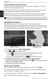
...the boat (according to identify entry and exit routes in the original packaging for backup or viewing purposes. Use the touchscreen to point to view details. Mariner's Eye 3D Settings To access additional settings or options from static electricity. To customize the appearance of the screen. ... Touch the button to move the view away from the SD card to your chartplotter is on BlueChart g2 Vision-compatible Garmin GPS units. is over the navaid, an option is displayed over 3D terrain. 16 GPSMAP 5000 Series Owner's Manual Style-select how chart data is 2. You can insert...
...the boat (according to identify entry and exit routes in the original packaging for backup or viewing purposes. Use the touchscreen to point to view details. Mariner's Eye 3D Settings To access additional settings or options from static electricity. To customize the appearance of the screen. ... Touch the button to move the view away from the SD card to your chartplotter is on BlueChart g2 Vision-compatible Garmin GPS units. is over the navaid, an option is displayed over 3D terrain. 16 GPSMAP 5000 Series Owner's Manual Style-select how chart data is 2. You can insert...
Owner's Manual
Page 74
...Of Range-entering a battery alarm voltage higher than expected. Cooling Fan Voltage Too High-the chartplotter's cooling fan voltage is a short in directory. 70 GPSMAP 5000 Series Owner's Manual Database Error-general database error. Directory Item With This MMSI Already... position not within the specified safe depth. travel to the GPS 17 antenna. Check speed wheel for assistance updating your chartplotter software. Software Update Required-a software update is complete-touchscreen calibration successful. Contact product support for blockage and calibrate again....
...Of Range-entering a battery alarm voltage higher than expected. Cooling Fan Voltage Too High-the chartplotter's cooling fan voltage is a short in directory. 70 GPSMAP 5000 Series Owner's Manual Database Error-general database error. Directory Item With This MMSI Already... position not within the specified safe depth. travel to the GPS 17 antenna. Check speed wheel for assistance updating your chartplotter software. Software Update Required-a software update is complete-touchscreen calibration successful. Contact product support for blockage and calibrate again....


