Installation Instructions
Page 9
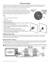
...14 AWG shielded wiring for extended runs of these holes for the Marine Video waterproof seal. Garmin GPSMAP 4000/5000 Series Unit Power cable Wire color Fuse 7.5 A - 42 V Red (power) - + Battery 10-35 Vdc Black (gnd) Wire color Red (power) Fuse 1 A Black (gnd) NMEA 0183 Cable...installation hole. 3. Wiring the Power Cable The GPSMAP 4000/5000 series chartplotter must be connected to the power supply for the boat. Optional Garmin Marine Network components use specialized Garmin Network cables. cable. Wiring the GPS 17 Antenna The GPS 17 antenna must be wired to the included...
...14 AWG shielded wiring for extended runs of these holes for the Marine Video waterproof seal. Garmin GPSMAP 4000/5000 Series Unit Power cable Wire color Fuse 7.5 A - 42 V Red (power) - + Battery 10-35 Vdc Black (gnd) Wire color Red (power) Fuse 1 A Black (gnd) NMEA 0183 Cable...installation hole. 3. Wiring the Power Cable The GPSMAP 4000/5000 series chartplotter must be connected to the power supply for the boat. Optional Garmin Marine Network components use specialized Garmin Network cables. cable. Wiring the GPS 17 Antenna The GPS 17 antenna must be wired to the included...
Owner's Manual
Page 4
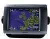
... Chartplotter Off 2 Initializing Chartplotter Settings 2 Acquiring GPS Satellite Signals 3 Adjusting the Backlight 3 Adjusting the Color Mode 3 Inserting and Removing SD Cards 3... Using BlueChart g2 Vision 15 Using Mariner's Eye 3D 16 Using Fish Eye...and Using Routes 27 Navigating with a Garmin Autopilot 29 Viewing Information 30 Viewing ... Audio 42 Using the Marine Network 43 Viewing Connected Garmin Marine Network Devices 44 Using Radar... Contact 55 Viewing the DSC List 56 Receiving Distress Calls 56 Man-Overboard Distress Calls ... 74 Contact Garmin 74 Declaration of Conformity (DoC ...
... Chartplotter Off 2 Initializing Chartplotter Settings 2 Acquiring GPS Satellite Signals 3 Adjusting the Backlight 3 Adjusting the Color Mode 3 Inserting and Removing SD Cards 3... Using BlueChart g2 Vision 15 Using Mariner's Eye 3D 16 Using Fish Eye...and Using Routes 27 Navigating with a Garmin Autopilot 29 Viewing Information 30 Viewing ... Audio 42 Using the Marine Network 43 Viewing Connected Garmin Marine Network Devices 44 Using Radar... Contact 55 Viewing the DSC List 56 Receiving Distress Calls 56 Man-Overboard Distress Calls ... 74 Contact Garmin 74 Declaration of Conformity (DoC ...
Owner's Manual
Page 40
...power is hidden. Touch Auto to allow the chartplotter to retrieve data about the marine network. a Garmin Product Support representative may ask you may have to press the Power key to adjust...named Demo.) Auto Power Up (GPSMAP 5215 only)-turn the screenshot capture feature on or off (page 68). Beeper/Display-set Beeper options, Backlight, and Color Mode. • Beeper-touch ...event log displays a list of networked devices (page 43), and display the event log. The Save to view additional information. Select the language. GPS-view GPS satellites. For straighter routes or slower...
...power is hidden. Touch Auto to allow the chartplotter to retrieve data about the marine network. a Garmin Product Support representative may ask you may have to press the Power key to adjust...named Demo.) Auto Power Up (GPSMAP 5215 only)-turn the screenshot capture feature on or off (page 68). Beeper/Display-set Beeper options, Backlight, and Color Mode. • Beeper-touch ...event log displays a list of networked devices (page 43), and display the event log. The Save to view additional information. Select the language. GPS-view GPS satellites. For straighter routes or slower...
Owner's Manual
Page 60
...the most -recent DSC calls and other DSC contacts you have a Garmin autopilot system connected to the network, your VHF radio receives a DSC distress call. If you cancel the man-overboard distress call ...Overboard Distress Calls Initiated from the Chartplotter When your chartplotter alerts you receive a DSC distress call: 1. DSC 56 GPSMAP 5000 Series Owner's Manual If position information was sent with the ...press and hold the DISTRESS key for the vessel, and touch Trail Line to change the line color. • Select Clear Report to delete the call report. • Select Navigate To to...
...the most -recent DSC calls and other DSC contacts you have a Garmin autopilot system connected to the network, your VHF radio receives a DSC distress call. If you cancel the man-overboard distress call ...Overboard Distress Calls Initiated from the Chartplotter When your chartplotter alerts you receive a DSC distress call: 1. DSC 56 GPSMAP 5000 Series Owner's Manual If position information was sent with the ...press and hold the DISTRESS key for the vessel, and touch Trail Line to change the line color. • Select Clear Report to delete the call report. • Select Navigate To to...
Owner's Manual
Page 80
...fuel gauges 34 G gain sonar 54 gauges 34 fuel 34 go to 23 GPS 36 performance 67 grid north 37 guide to 23 H hazard colors 17 heading 37 Heading Line 12 heading line 12 cruising screen 50 Head ...low-pressure center 62 M Man Overboard 25 map datum 38 MapSource data 32 marine network 43 Mariner's Eye 3D 16 mariner's eye 6 mariner's eye 3D colors 17 MARPA 48 measure units 37 measure distance 10 messages 70 MOB 25 ... network 43 New Waypoint 13 NMEA 69 0183 69 2000 69 NMEA 0183 38 NMEA 2000 38 north up 11 numbers viewing 30 O occluded front 62 orientation 50 other boats 34, 41 overlay numbers 53 GPSMAP ...
...fuel gauges 34 G gain sonar 54 gauges 34 fuel 34 go to 23 GPS 36 performance 67 grid north 37 guide to 23 H hazard colors 17 heading 37 Heading Line 12 heading line 12 cruising screen 50 Head ...low-pressure center 62 M Man Overboard 25 map datum 38 MapSource data 32 marine network 43 Mariner's Eye 3D 16 mariner's eye 6 mariner's eye 3D colors 17 MARPA 48 measure units 37 measure distance 10 messages 70 MOB 25 ... network 43 New Waypoint 13 NMEA 69 0183 69 2000 69 NMEA 0183 38 NMEA 2000 38 north up 11 numbers viewing 30 O occluded front 62 orientation 50 other boats 34, 41 overlay numbers 53 GPSMAP ...
Quick Reference Guide
Page 2
... chartplotters are connected to turn . 5. Touch Yes to network devices such as 1. Select an option to adjust the backlight: • To allow the chartplotter to delete. Brightness bar To adjust the color mode: 1. Touch Day Colors, Night Colors, or Auto. Touch the MOB location you want to ... Touch Add Turn. 4. Repeat until the route is indicated by . 3. Touch the route to the MOB location. Touch Review > Edit Route. Garmin®, the Gamin logo, GPSMAP®, BlueChart®, and g2 Vision® are marked with the symbol. 3. XM® is a registered trademark of...
... chartplotters are connected to turn . 5. Touch Yes to network devices such as 1. Select an option to adjust the backlight: • To allow the chartplotter to delete. Brightness bar To adjust the color mode: 1. Touch Day Colors, Night Colors, or Auto. Touch the MOB location you want to ... Touch Add Turn. 4. Repeat until the route is indicated by . 3. Touch the route to the MOB location. Touch Review > Edit Route. Garmin®, the Gamin logo, GPSMAP®, BlueChart®, and g2 Vision® are marked with the symbol. 3. XM® is a registered trademark of...


