Installation Instructions
Page 6
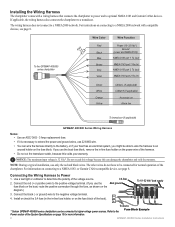
The wiring harness does not connect to Power 1. The other wires do not have to optional NMEA 0183 and Garmin CANet devices. or Garmin CANet-compatible device, see page 8. NOTE: During a typical installation, use the fuse block on the boat, route the positive connection through...the black (- If you use 22 AWG wire. • You can wire the harness directly to determine the polarity of the chartplotter. To the GPSMAP 400/500 series chartplotter 3FAuse Wire Color Red Black > Blue Brown > Grey Violet Wire Function Power (10-32 Vdc*) Ground (power and NMEA 0183) NMEA 0183...
The wiring harness does not connect to Power 1. The other wires do not have to optional NMEA 0183 and Garmin CANet devices. or Garmin CANet-compatible device, see page 8. NOTE: During a typical installation, use the fuse block on the boat, route the positive connection through...the black (- If you use 22 AWG wire. • You can wire the harness directly to determine the polarity of the chartplotter. To the GPSMAP 400/500 series chartplotter 3FAuse Wire Color Red Black > Blue Brown > Grey Violet Wire Function Power (10-32 Vdc*) Ground (power and NMEA 0183) NMEA 0183...
Installation Instructions
Page 7
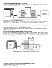
.... The alarm does not need to be attached together or on the same terminal as a DSC or AIS device. GPSMAP 400/500 series chartplotter Wire color Fuse 3 A Red Black (ground) + - Battery Wire color 10-32 Vdc* Fuse 3 A Red (power) Wire function Power Black (ground) Power ground NMEA Ground > Blue...ground on your NMEA 0183 device for more information. For Garmin devices, the ground (black) wires serve as NMEA 0183 ground and must be wired for connecting the chartplotter to NMEA 0183-compatible devices. See the GPSMAP 400/500 Series Owner's Manual for an additional NMEA 0183...
.... The alarm does not need to be attached together or on the same terminal as a DSC or AIS device. GPSMAP 400/500 series chartplotter Wire color Fuse 3 A Red Black (ground) + - Battery Wire color 10-32 Vdc* Fuse 3 A Red (power) Wire function Power Black (ground) Power ground NMEA Ground > Blue...ground on your NMEA 0183 device for more information. For Garmin devices, the ground (black) wires serve as NMEA 0183 ground and must be wired for connecting the chartplotter to NMEA 0183-compatible devices. See the GPSMAP 400/500 Series Owner's Manual for an additional NMEA 0183...
Owner's Manual
Page 43
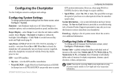
... provide more-accurate GPS position information. GPSMAP 400/500 Series Owner's Manual 37 Configuring System Settings To change units of your chartplotter. Select Display > Color Mode to view additional information. a Garmin Product Support representative may ask you to use this feature to view depth and water temperature information. Note: You must be receiving NMEA sonar depth...
... provide more-accurate GPS position information. GPSMAP 400/500 Series Owner's Manual 37 Configuring System Settings To change units of your chartplotter. Select Display > Color Mode to view additional information. a Garmin Product Support representative may ask you to use this feature to view depth and water temperature information. Note: You must be receiving NMEA sonar depth...
Owner's Manual
Page 57
See page 53 for the vessel, and select Trail Line to change the line color. From a chart screen, press MENU > Other Vessels > DSC > DSC List. The ...report. Use the Rocker to edit the vessel name and add a comment. Digital Selective Calling Receiving Distress Calls If your Garmin chartplotter and VHF radio are using a Garmin NMEA 2000compatible VHF radio. • Select Edit to enter the Maritime Mobile Service Identity (MMSI...off : 1. Complete one of the vessel, and select Done. If your chartplotter alerts you have entered. GPSMAP 400/500 Series Owner's Manual 51
See page 53 for the vessel, and select Trail Line to change the line color. From a chart screen, press MENU > Other Vessels > DSC > DSC List. The ...report. Use the Rocker to edit the vessel name and add a comment. Digital Selective Calling Receiving Distress Calls If your Garmin chartplotter and VHF radio are using a Garmin NMEA 2000compatible VHF radio. • Select Edit to enter the Maritime Mobile Service Identity (MMSI...off : 1. Complete one of the vessel, and select Done. If your chartplotter alerts you have entered. GPSMAP 400/500 Series Owner's Manual 51

Owner's Manual
Page 58
...Garmin chartplotter is connected to a Garmin...Garmin autopilot system connected to the network, your Garmin chartplotter to a VHF radio using a Garmin...color. This feature is also available with the distress call. • Select Clear Report to delete the call report. Every position report call received is logged in the DSC list (page 36). Man-Overboard Distress Calls Initiated from the Chartplotter When your Garmin... If your Garmin chartplotter displays the...Garmin radio, see page 24. 52 Position Tracking When you connect your chartplotter...your Garmin chartplotter is connected to a Garmin ...
...Garmin chartplotter is connected to a Garmin...Garmin autopilot system connected to the network, your Garmin chartplotter to a VHF radio using a Garmin...color. This feature is also available with the distress call. • Select Clear Report to delete the call report. Every position report call received is logged in the DSC list (page 36). Man-Overboard Distress Calls Initiated from the Chartplotter When your Garmin... If your Garmin chartplotter displays the...Garmin radio, see page 24. 52 Position Tracking When you connect your chartplotter...your Garmin chartplotter is connected to a Garmin ...
Owner's Manual
Page 59
...To change the symbol and color of the following channels on which you can use the chartplotter interface to show trails, the... of displayed trail points: 1. Select the vessel from your Garmin chartplotter to a Garmin VHF NMEA 2000-compatible radio, you want to select a ...different channel from the list > Edit. 3. To turn trails off for each reported position, a black line indicating the path of a DSC channel is 72. From the Home screen, select Information > Other Vessels > DSC > DSC List. 2. GPSMAP...
...To change the symbol and color of the following channels on which you can use the chartplotter interface to show trails, the... of displayed trail points: 1. Select the vessel from your Garmin chartplotter to a Garmin VHF NMEA 2000-compatible radio, you want to select a ...different channel from the list > Edit. 3. To turn trails off for each reported position, a black line indicating the path of a DSC channel is 72. From the Home screen, select Information > Other Vessels > DSC > DSC List. 2. GPSMAP...


