
Owner's Manual
Page 5
... 79 Flasher Page 84 Map Split Page 85 Appendix 86 Specifications 86 Installing the GPSMAP 492/498 External GPS Antenna..... 87 Mounting the GPSMAP 392/398/492/498 88 Installing the Transducer 90 Connecting the Power/Data Cable 92 Interfacing 93 Installing and Removing Data Cards 94 Satellite Information 95 INTRODUCTION > TABLE OF CONTENTS... System 103 Optional Accessories 105 Software License Agreement 106 Product Registration 106 Limited Warranty 107 FCC Compliance 108 Declaration of Conformity (DoC 108 Index 109 GPSMAP 392/398/492/498 Owner's Manual iii
... 79 Flasher Page 84 Map Split Page 85 Appendix 86 Specifications 86 Installing the GPSMAP 492/498 External GPS Antenna..... 87 Mounting the GPSMAP 392/398/492/498 88 Installing the Transducer 90 Connecting the Power/Data Cable 92 Interfacing 93 Installing and Removing Data Cards 94 Satellite Information 95 INTRODUCTION > TABLE OF CONTENTS... System 103 Optional Accessories 105 Software License Agreement 106 Product Registration 106 Limited Warranty 107 FCC Compliance 108 Declaration of Conformity (DoC 108 Index 109 GPSMAP 392/398/492/498 Owner's Manual iii
Owner's Manual
Page 29
...Cable" on the map has information about the point available. When any nearby rescuer receives the DSC signal, an alarm sounds and they immediately receive the location of data loaded on the GPSMAP 392/398/492/498... the Coast Guard receives the Information Window GPSMAP 392/398/492/498 Owner's Manual 21 Use the ROCKER to highlight the individual tabs, and show alerts from a GPS to the Coast ... single transmission or call properties received from the VHF radio on to transmit position coordinates for a Map item: 1. DSC uses marine VHF radio and GPS technologies to assist, or forward...
...Cable" on the map has information about the point available. When any nearby rescuer receives the DSC signal, an alarm sounds and they immediately receive the location of data loaded on the GPSMAP 392/398/492/498... the Coast Guard receives the Information Window GPSMAP 392/398/492/498 Owner's Manual 21 Use the ROCKER to highlight the individual tabs, and show alerts from a GPS to the Coast ... single transmission or call properties received from the VHF radio on to transmit position coordinates for a Map item: 1. DSC uses marine VHF radio and GPS technologies to assist, or forward...

Owner's Manual
Page 55
A list of stored waypoints appear to a computer using an optional PC cable and interface software or record them manually. The total number of the User page, with the stored waypoints arranged in memory. From the User list, ... waypoints is advisable to back up important waypoints to the right of all user waypoints. User Waypoint List The User list on the ROCKER. GPSMAP 392/398/492/498 Owner's Manual 47 Press right one time on the points tab shows a master list of the Main Menu list. 2. Press down on the...
A list of stored waypoints appear to a computer using an optional PC cable and interface software or record them manually. The total number of the User page, with the stored waypoints arranged in memory. From the User list, ... waypoints is advisable to back up important waypoints to the right of all user waypoints. User Waypoint List The User list on the ROCKER. GPSMAP 392/398/492/498 Owner's Manual 47 Press right one time on the points tab shows a master list of the Main Menu list. 2. Press down on the...

Owner's Manual
Page 89
...wide beam (out to manually enter a calibration, press ENTER on the size of the speed sensor cables. If you are using dual beam, fish symbols from the narrow beam (directly underneath ... previous with the target depth shown. Suspended targets appear as symbols. Both the top GPS ground speed and uncalibrated water speed appear at the bottom of the calibration window. NOTE...select a fish symbol, the GPSMAP 392/398/492/498 identifies some returns for you want to the sides of the screen. GPSMAP 392/398/492/498 Owner's Manual 81 Suspended targets appear as...
...wide beam (out to manually enter a calibration, press ENTER on the size of the speed sensor cables. If you are using dual beam, fish symbols from the narrow beam (directly underneath ... previous with the target depth shown. Suspended targets appear as symbols. Both the top GPS ground speed and uncalibrated water speed appear at the bottom of the calibration window. NOTE...select a fish symbol, the GPSMAP 392/398/492/498 identifies some returns for you want to the sides of the screen. GPSMAP 392/398/492/498 Owner's Manual 81 Suspended targets appear as...
Owner's Manual
Page 95
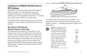
..., doing so voids the antenna warranty. Installing the GPSMAP 492/498 External GPS Antenna The GPSMAP 492/498 with a new solder-on or crimp BNC connector. Most marine VHF and LORAN antennas should avoid mounting the antenna high on the coaxial cable and the coaxial cable shortened to route the coaxial cable either through, or outside the antenna mount...
..., doing so voids the antenna warranty. Installing the GPSMAP 492/498 External GPS Antenna The GPSMAP 492/498 with a new solder-on or crimp BNC connector. Most marine VHF and LORAN antennas should avoid mounting the antenna high on the coaxial cable and the coaxial cable shortened to route the coaxial cable either through, or outside the antenna mount...

Owner's Manual
Page 96
...consider the following conditions: • There should be heavy enough to secure the cable along the route and through any bulkhead or deck. 3. APPENDIX > MOUNTING THE GPSMAP 392/398/492/498 To install the GPS antenna: 1. Avoid mounting the unit where it is suitable for the display unit..., make sure you turn the antenna cable connector 1/4 turn clockwise to the mounting location of the screen...
...consider the following conditions: • There should be heavy enough to secure the cable along the route and through any bulkhead or deck. 3. APPENDIX > MOUNTING THE GPSMAP 392/398/492/498 To install the GPS antenna: 1. Avoid mounting the unit where it is suitable for the display unit..., make sure you turn the antenna cable connector 1/4 turn clockwise to the mounting location of the screen...
Owner's Manual
Page 99
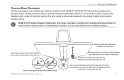
...;ttings, water intake, or discharge ports, or anything that my degrade the boat's performance and damage the prop. 91 Apply marine sealant to all screw threads to prevent water from your warranty. Do not mount the transducer directly in clean (non-turbulent) ... Mount Transducer The following diagram is for optimal performance. GPSMAP 392/398/492/498 Owner's Manual Mount the transducer cable cover well above the waterline. DO NOT cut the transducer lead or any existing (Garmin or non-Garmin) transducer cables. Transducer should extend 1/8" below the fiberglass hull...
...;ttings, water intake, or discharge ports, or anything that my degrade the boat's performance and damage the prop. 91 Apply marine sealant to all screw threads to prevent water from your warranty. Do not mount the transducer directly in clean (non-turbulent) ... Mount Transducer The following diagram is for optimal performance. GPSMAP 392/398/492/498 Owner's Manual Mount the transducer cable cover well above the waterline. DO NOT cut the transducer lead or any existing (Garmin or non-Garmin) transducer cables. Transducer should extend 1/8" below the fiberglass hull...
Owner's Manual
Page 100
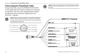
.... Accessory On DC Power Source CANet L CANet H 92 GPSMAP 392/398/492/498 Owner's Manual The color code in the diagram below indicates the appropriate harness connections. APPENDIX > CONNECTING THE POWER/DATA CABLE Connecting the Power/Data Cable The power/data cable connects the GPSMAP 392/398/492/498 to be connected for connecting external devices. Replacement...
.... Accessory On DC Power Source CANet L CANet H 92 GPSMAP 392/398/492/498 Owner's Manual The color code in the diagram below indicates the appropriate harness connections. APPENDIX > CONNECTING THE POWER/DATA CABLE Connecting the Power/Data Cable The power/data cable connects the GPSMAP 392/398/492/498 to be connected for connecting external devices. Replacement...
Owner's Manual
Page 110
... connected to has either been disconnected or the GPSMAP 392/492 has lost communication with the sonar device for new entries. 102 GPSMAP 392/398/492/498 Owner's Manual Transducer Disconnected, Sonar Turned Off-there is full. If the transducer cable is removed while the unit is on . ...APPENDIX > MESSAGES Sonar Service Incompatible-(only applied to the GPSMAP 392/492) the external sonar ...
... connected to has either been disconnected or the GPSMAP 392/492 has lost communication with the sonar device for new entries. 102 GPSMAP 392/398/492/498 Owner's Manual Transducer Disconnected, Sonar Turned Off-there is full. If the transducer cable is removed while the unit is on . ...APPENDIX > MESSAGES Sonar Service Incompatible-(only applied to the GPSMAP 392/492) the external sonar ...
Owner's Manual
Page 113
...ush on the other compatible device on the bulkhead or cabin wall. at 800-800-1020, or Garmin Europe at high speed through your GPSMAP 392/398/492/498 using a standard AC house current. BlueChart g2 Preprogramed Data Cards-enhances the basemap featuring additional data like...to a vehicle's electrical system on one end, and a PC, beacon receiver, marine autopilot, or other end. PC Interface Cable with Vehicle Power Adapter-connects the GPSMAP 392/398/492/498 to the GPSMAP 392/398/492/498 and void the warranty. Optional Accessories The following optional accessories are compatible ...
...ush on the other compatible device on the bulkhead or cabin wall. at 800-800-1020, or Garmin Europe at high speed through your GPSMAP 392/398/492/498 using a standard AC house current. BlueChart g2 Preprogramed Data Cards-enhances the basemap featuring additional data like...to a vehicle's electrical system on one end, and a PC, beacon receiver, marine autopilot, or other end. PC Interface Cable with Vehicle Power Adapter-connects the GPSMAP 392/398/492/498 to the GPSMAP 392/398/492/498 and void the warranty. Optional Accessories The following optional accessories are compatible ...


