Owner's Manual (for Europe)
Page 86
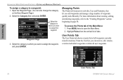
... waypoints, refer to which you edit waypoints and manage a large number of tabs. To access the Points tab of all user waypoints. User Points Tab 78 GPSMAP 496 Owner's Manual User Points Tab The User Points tab shows a master list of the Main Menu: 1. Open the Waypoint Page. (You can review, edit, rename...
... waypoints, refer to which you edit waypoints and manage a large number of tabs. To access the Points tab of all user waypoints. User Points Tab 78 GPSMAP 496 Owner's Manual User Points Tab The User Points tab shows a master list of the Main Menu: 1. Open the Waypoint Page. (You can review, edit, rename...
Owner's Manual (for Europe)
Page 121
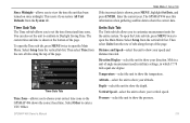
.... Then select Time from the row of tabs along the top of angle measurement used in military settings, in which 17.78 mils equal one degree. The GPSMAP 496 uses this information when gathering satellite data to show your speed and distance traveled. Select Setup from the vertical tab list. ...Enter the current year. Distance and Speed-select the unit to show your correct time zone so the GPSMAP 496 shows the correct local time. Altitude-select the unit to show the pressure. Main Menu > Setup Tab Units Sub Tab The Units sub tab...
.... Then select Time from the row of tabs along the top of angle measurement used in military settings, in which 17.78 mils equal one degree. The GPSMAP 496 uses this information when gathering satellite data to show your speed and distance traveled. Select Setup from the vertical tab list. ...Enter the current year. Distance and Speed-select the unit to show your correct time zone so the GPSMAP 496 shows the correct local time. Altitude-select the unit to show the pressure. Main Menu > Setup Tab Units Sub Tab The Units sub tab...
Owner's Manual (for Europe)
Page 159
... speed 46 Current Route page 61 automotive mode 67 custom avoids 62, 111 GPSMAP 496 Owner's Manual 151 Index Index Symbols 2D 5, 58, 127 3D 5, 58 A accessories 133 acquiring satellites 5 Active Route page aviation mode 43 Active Track tab 82, 85 add to route 75 approach 16,... 22, 23, 43 ARTCC 17 assign category 78 asterisk (*) 16 audio connector 1 AutoLocate 3, 5 average location 75 avoids 62, 111 B ...
... speed 46 Current Route page 61 automotive mode 67 custom avoids 62, 111 GPSMAP 496 Owner's Manual 151 Index Index Symbols 2D 5, 58, 127 3D 5, 58 A accessories 133 acquiring satellites 5 Active Route page aviation mode 43 Active Track tab 82, 85 add to route 75 approach 16,... 22, 23, 43 ARTCC 17 assign category 78 asterisk (*) 16 audio connector 1 AutoLocate 3, 5 average location 75 avoids 62, 111 B ...

Owner's Manual (for Europe)
Page 161
..., 30 PC interface cable 136 persistent alarm 99 plan flight 43, 72 plan route 43, 72 points of interest 53 Points tab 78 pop-up alerts 27 position data page aviation mode 44 position mode 28 position report 143-144 power 2, 3, 134 connector 1, 4 practice mode. K keypad 7 L land at...menu Display Tab 107 GPS tab 4 Sound Tab 108 managing routes 69 managing tracks 82 managing waypoints 73 Man OverBoard 87 GPSMAP 496 Owner's Manual map information 35, 55 MapSource 10, 137 map data 35 map datum 142 map orientation 29 Map Page automotive mode 64 aviation mode 28-35 ...
..., 30 PC interface cable 136 persistent alarm 99 plan flight 43, 72 plan route 43, 72 points of interest 53 Points tab 78 pop-up alerts 27 position data page aviation mode 44 position mode 28 position report 143-144 power 2, 3, 134 connector 1, 4 practice mode. K keypad 7 L land at...menu Display Tab 107 GPS tab 4 Sound Tab 108 managing routes 69 managing tracks 82 managing waypoints 73 Man OverBoard 87 GPSMAP 496 Owner's Manual map information 35, 55 MapSource 10, 137 map data 35 map datum 142 map orientation 29 Map Page automotive mode 64 aviation mode 28-35 ...
Owner's Manual (for Europe)
Page 163
... 3 waterproof vi water speed 125 water temp 101 waypoint 15, 25, 58-60 categories 77, 78 create 25, 59, 76 edit 73, 74 Information Page 55 manage 73 mark 25 name 74 proximity 81 symbol 74 GPSMAP 496 Owner's Manual 155 See VNAV vertical speed 113 VHF 143 VHF Comm 131 VHF Comm...
... 3 waterproof vi water speed 125 water temp 101 waypoint 15, 25, 58-60 categories 77, 78 create 25, 59, 76 edit 73, 74 Information Page 55 manage 73 mark 25 name 74 proximity 81 symbol 74 GPSMAP 496 Owner's Manual 155 See VNAV vertical speed 113 VHF 143 VHF Comm 131 VHF Comm...
Owner's Manual (for North America)
Page 4
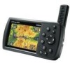
...Manual i Warnings v Battery Warnings vi Important Information vi Getting Started 1 Unit Overview 1 Charging the GPSMAP 496 2 Turning On the GPSMAP 496 3 Getting Satellite Signals 4 Learning About the Keypad 7 Using the GPSMAP 496 8 Simulator Mode 11 Basic Operation In Aviation Mode 13 Aviation Mode Page Sequence 13 Creating a Direct To 14 Finding a Nearby Point 18 Selecting an Approach... 69 Map Page 69 Highway Page 70 Current Route Page 72 Trip Computer 73 Editing and Managing Routes 74 Editing and Managing Waypoints 78 Managing Your Tracks 87 GPSMAP 496 Owner's Manual
...Manual i Warnings v Battery Warnings vi Important Information vi Getting Started 1 Unit Overview 1 Charging the GPSMAP 496 2 Turning On the GPSMAP 496 3 Getting Satellite Signals 4 Learning About the Keypad 7 Using the GPSMAP 496 8 Simulator Mode 11 Basic Operation In Aviation Mode 13 Aviation Mode Page Sequence 13 Creating a Direct To 14 Finding a Nearby Point 18 Selecting an Approach... 69 Map Page 69 Highway Page 70 Current Route Page 72 Trip Computer 73 Editing and Managing Routes 74 Editing and Managing Waypoints 78 Managing Your Tracks 87 GPSMAP 496 Owner's Manual
Owner's Manual (for North America)
Page 34
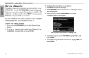
...For more information about editing waypoints, see the "Editing and Managing Waypoints" section beginning on page 78. Press Page to open the Information Page for the map item. Aviation Basic Operation in Aviation Mode > Marking a Waypoint Marking a Waypoint Waypoints are locations or landmarks you want to save...the location you record and store in your GPSMAP 496. To accept the waypoint with the default name, highlight OK, and press Enter. 26 GPSMAP 496 Owner's Manual Press Menu twice and open the GPS tab to mark your satellite receiver status. You must have a valid 2D or...
...For more information about editing waypoints, see the "Editing and Managing Waypoints" section beginning on page 78. Press Page to open the Information Page for the map item. Aviation Basic Operation in Aviation Mode > Marking a Waypoint Marking a Waypoint Waypoints are locations or landmarks you want to save...the location you record and store in your GPSMAP 496. To accept the waypoint with the default name, highlight OK, and press Enter. 26 GPSMAP 496 Owner's Manual Press Menu twice and open the GPS tab to mark your satellite receiver status. You must have a valid 2D or...
Owner's Manual (for North America)
Page 84
...name of the waypoint properties on the Waypoint Page (see the "Editing and Managing Waypoints" section beginning on the route by pressing Enter repeatedly. 76 GPSMAP 496 Owner's Manual Press Menu twice to select the route, and press Enter. 3. Use the ROCKER to open the Main Menu. Automotive Route Review ... to select Route. 2. Use the ROCKER to highlight the spot in the route is a user waypoint, you want to review each point on page 78). Press Menu twice, and highlight Route. 2. On the point review page, choose Next (highlight the next point on the route list), Show Map ...
...name of the waypoint properties on the Waypoint Page (see the "Editing and Managing Waypoints" section beginning on the route by pressing Enter repeatedly. 76 GPSMAP 496 Owner's Manual Press Menu twice to select the route, and press Enter. 3. Use the ROCKER to open the Main Menu. Automotive Route Review ... to select Route. 2. Use the ROCKER to highlight the spot in the route is a user waypoint, you want to review each point on page 78). Press Menu twice, and highlight Route. 2. On the point review page, choose Next (highlight the next point on the route list), Show Map ...
Owner's Manual (for North America)
Page 86
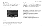
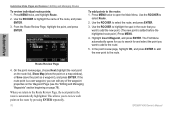
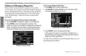
... ROCKER to show the Waypoint Edit Page. To access the Waypoint Edit Page: 1. If the waypoint is located on the Map Page. 2. Waypoint Review Page 78 GPSMAP 496 Owner's Manual Press Enter to highlight Points from the vertical list of these pages as the "Waypoint Pages," unless it at that location. Use either...
... ROCKER to show the Waypoint Edit Page. To access the Waypoint Edit Page: 1. If the waypoint is located on the Map Page. 2. Waypoint Review Page 78 GPSMAP 496 Owner's Manual Press Enter to highlight Points from the vertical list of these pages as the "Waypoint Pages," unless it at that location. Use either...
Owner's Manual (for North America)
Page 127
...the row of tabs along the top of angle measurement used in military settings, in which 17.78 mils equal one degree. Depth-select the unit to show your direction. To open the Units sub...measurement units for the entire system. Pressure-select the unit to show the pressure. GPSMAP 496 Owner's Manual 119 Time Sub Tab Time Zone-allows you to choose your altitude. Then select ...Units from the System tab. The GPSMAP 496 uses this information when gathering satellite data to show the correct date. Main Menu > Setup...
...the row of tabs along the top of angle measurement used in military settings, in which 17.78 mils equal one degree. Depth-select the unit to show your direction. To open the Units sub...measurement units for the entire system. Pressure-select the unit to show the pressure. GPSMAP 496 Owner's Manual 119 Time Sub Tab Time Zone-allows you to choose your altitude. Then select ...Units from the System tab. The GPSMAP 496 uses this information when gathering satellite data to show the correct date. Main Menu > Setup...
Owner's Manual (for North America)
Page 190
... your flight plan 28 follow roads 62 FSS 18 fuel flow 44, 47, 77 G GARMIN DGPS 122 getting satellite signals 4-6 going to a destination 56 go to 14, 15, 84... distress call 100 history 59 page 15, 23 point 92 position report 100 GPS 163-164 learning about 163 Off/On 5 page 6, 74 GRI chain 166 GSD 20A ...GPSMAP 496 Owner's Manual See DSC direction display 119 Direct To 14, 19 display tab 114 distance and speed 119 distress calls 97-100, 168-169 drift alarm 108 DSC 96-100, 168-169 E E6B 49-50 edit route 75, 76, 77 waypoints 78, 79 elevation 119 emergency aviation...
... your flight plan 28 follow roads 62 FSS 18 fuel flow 44, 47, 77 G GARMIN DGPS 122 getting satellite signals 4-6 going to a destination 56 go to 14, 15, 84... distress call 100 history 59 page 15, 23 point 92 position report 100 GPS 163-164 learning about 163 Off/On 5 page 6, 74 GRI chain 166 GSD 20A ...GPSMAP 496 Owner's Manual See DSC direction display 119 Direct To 14, 19 display tab 114 distance and speed 119 distress calls 97-100, 168-169 drift alarm 108 DSC 96-100, 168-169 E E6B 49-50 edit route 75, 76, 77 waypoints 78, 79 elevation 119 emergency aviation...

Owner's Manual (for North America)
Page 191
... 106 plan flight 44, 77 plan route 44, 77 points of interest 58 Points tab 83 pop-up alerts 28 position 163 position data page aviation mode 45 Index 183 intersection 170 J Jeppesen database 27, 170 updates 10 K keypad 7 L land at closest point 19 language 116 legs, ...main menu Display Tab 114 GPS tab 4 GPSMAP 496 Owner's Manual Sound Tab 115 managing routes 74 managing tracks 87 managing waypoints 78 Man OverBoard 92 map information 36, 60 MapSource 10, 160 map data 36 map datum 167 map orientation 30 Map Page automotive mode 69 aviation mode 29-36 declutter ...
... 106 plan flight 44, 77 plan route 44, 77 points of interest 58 Points tab 83 pop-up alerts 28 position 163 position data page aviation mode 45 Index 183 intersection 170 J Jeppesen database 27, 170 updates 10 K keypad 7 L land at closest point 19 language 116 legs, ...main menu Display Tab 114 GPS tab 4 GPSMAP 496 Owner's Manual Sound Tab 115 managing routes 74 managing tracks 87 managing waypoints 78 Man OverBoard 92 map information 36, 60 MapSource 10, 160 map data 36 map datum 167 map orientation 30 Map Page automotive mode 69 aviation mode 29-36 declutter ...
Owner's Manual (for North America)
Page 192
... usable 5 receiver status 5 receive satellite signals 3 record mode 87, 90 reference position 59 release hold 41 reset timer 118 reset trip 45, 73 retrace your path 90 review route 75 waypoint 78 road 70 road routing tab 117 184 route 76, 90 add points 76 add waypoint to 80 ... Moon tab 109 switch modes 13, 55, 91 system alarms 107 System tab 116 T temperature 119, 146 terrain alert 28 Terrain Page aviation mode 37-39 declutter 33 terrain warning 38 text language 116 thermoclines 145 tide chart 111 information 110 station 111 tab 110 time GPSMAP 496 Owner's Manual
... usable 5 receiver status 5 receive satellite signals 3 record mode 87, 90 reference position 59 release hold 41 reset timer 118 reset trip 45, 73 retrace your path 90 review route 75 waypoint 78 road 70 road routing tab 117 184 route 76, 90 add points 76 add waypoint to 80 ... Moon tab 109 switch modes 13, 55, 91 system alarms 107 System tab 116 T temperature 119, 146 terrain alert 28 Terrain Page aviation mode 37-39 declutter 33 terrain warning 38 text language 116 thermoclines 145 tide chart 111 information 110 station 111 tab 110 time GPSMAP 496 Owner's Manual
Owner's Manual (for North America)
Page 193
...trip computer 73 trip planning 77 true airspeed 50 tuning beacon 164 turn-by-turn route 56, 66, 75 turn on terrain 37 Z zoom 30 GPSMAP 496 Owner's Manual 185 See VNAV vertical speed 119 VHF 168 VHF Comm 154 view details 31 VNAV 42, 43 indicator 42 profile 42 volume 3, 115... waterproof 156 water speed 141 water temp 108 waypoint 15, 26, 63-65, 163 categories 82, 83 create 26, 64, 81 edit 78, 79 Information Page 60 manage 78 mark 26 name 79 proximity 86 symbol 79 transition 74 weather information finding 133 Weather tab 130 options menu 131 weight & balance 48...
...trip computer 73 trip planning 77 true airspeed 50 tuning beacon 164 turn-by-turn route 56, 66, 75 turn on terrain 37 Z zoom 30 GPSMAP 496 Owner's Manual 185 See VNAV vertical speed 119 VHF 168 VHF Comm 154 view details 31 VNAV 42, 43 indicator 42 profile 42 volume 3, 115... waterproof 156 water speed 141 water temp 108 waypoint 15, 26, 63-65, 163 categories 82, 83 create 26, 64, 81 edit 78, 79 Information Page 60 manage 78 mark 26 name 79 proximity 86 symbol 79 transition 74 weather information finding 133 Weather tab 130 options menu 131 weight & balance 48...
