Owner's Manual (for Europe)
Page 4
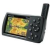
...Information v Care Information vi Getting Started 1 Unit Overview 1 Charging the GPSMAP 496 2 Turning On the GPSMAP 496 3 Getting Satellite Signals 4 Learning About the Keypad 7 Using the GPSMAP 496 8 Simulator Mode 11 Basic Operation In Aviation Mode 13 Aviation Mode Page Sequence 13 Creating a Direct To 14 Finding a Nearby ... Editing Your Route 62 Automotive Mode Pages and Features 64 Map Page 64 Highway Page 65 Current Route Page 67 Trip Computer 68 Editing and Managing Routes 69 Editing and Managing Waypoints 73 Managing Your Tracks 82 ii GPSMAP 496 Owner's Manual
...Information v Care Information vi Getting Started 1 Unit Overview 1 Charging the GPSMAP 496 2 Turning On the GPSMAP 496 3 Getting Satellite Signals 4 Learning About the Keypad 7 Using the GPSMAP 496 8 Simulator Mode 11 Basic Operation In Aviation Mode 13 Aviation Mode Page Sequence 13 Creating a Direct To 14 Finding a Nearby ... Editing Your Route 62 Automotive Mode Pages and Features 64 Map Page 64 Highway Page 65 Current Route Page 67 Trip Computer 68 Editing and Managing Routes 69 Editing and Managing Waypoints 73 Managing Your Tracks 82 ii GPSMAP 496 Owner's Manual
Owner's Manual (for Europe)
Page 72
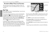
... 28-35 in the "Aviation Mode Pages" section for the Map Page. Change the page layout and data fields to change the map range. When you would like to a certain level. Map Page Map zoom range Press the zoom keys (In and Out) to customize the Map Page. 64 GPSMAP 496 Owner's Manual Use... any one of the possible data options. Press Menu to measure the distance between two objects on the right side of the screen shows the GPS status or the route leg. Current location Data fields Map Page Refer to keep the white arrow (map pointer) within the screen area. You can...
... 28-35 in the "Aviation Mode Pages" section for the Map Page. Change the page layout and data fields to change the map range. When you would like to a certain level. Map Page Map zoom range Press the zoom keys (In and Out) to customize the Map Page. 64 GPSMAP 496 Owner's Manual Use... any one of the possible data options. Press Menu to measure the distance between two objects on the right side of the screen shows the GPS status or the route leg. Current location Data fields Map Page Refer to keep the white arrow (map pointer) within the screen area. You can...

Owner's Manual (for Europe)
Page 161
... persistent alarm 99 plan flight 43, 72 plan route 43, 72 points of interest 53 Points tab 78 pop-up alerts 27 position data page aviation mode 44 position mode 28 position report 143-144 power 2, 3, 134 connector 1, 4 practice mode. K keypad 7 L land at closest point 18 ...menu Display Tab 107 GPS tab 4 Sound Tab 108 managing routes 69 managing tracks 82 managing waypoints 73 Man OverBoard 87 GPSMAP 496 Owner's Manual map information 35, 55 MapSource 10, 137 map data 35 map datum 142 map orientation 29 Map Page automotive mode 64 aviation mode 28-35 declutter...
... persistent alarm 99 plan flight 43, 72 plan route 43, 72 points of interest 53 Points tab 78 pop-up alerts 27 position data page aviation mode 44 position mode 28 position report 143-144 power 2, 3, 134 connector 1, 4 practice mode. K keypad 7 L land at closest point 18 ...menu Display Tab 107 GPS tab 4 Sound Tab 108 managing routes 69 managing tracks 82 managing waypoints 73 Man OverBoard 87 GPSMAP 496 Owner's Manual map information 35, 55 MapSource 10, 137 map data 35 map datum 142 map orientation 29 Map Page automotive mode 64 aviation mode 28-35 declutter...
Owner's Manual (for North America)
Page 72
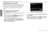
... Basic Operation in Automotive Mode > Creating Waypoints Creating Waypoints From the Map You can create a waypoint using the Map Page: 1. The GPSMAP 496 uses the map item text shown on the New Map Waypoint Page, highlight the appropriate field, and press Enter. Pressing and holding Enter/...Mark, marks your changes, highlight OK, and press Enter. 64 GPSMAP 496 Owner's Manual When you press Enter. Press and quickly release Enter/Mark to the map location, or map feature. 3. Use the ROCKER...
... Basic Operation in Automotive Mode > Creating Waypoints Creating Waypoints From the Map You can create a waypoint using the Map Page: 1. The GPSMAP 496 uses the map item text shown on the New Map Waypoint Page, highlight the appropriate field, and press Enter. Pressing and holding Enter/...Mark, marks your changes, highlight OK, and press Enter. 64 GPSMAP 496 Owner's Manual When you press Enter. Press and quickly release Enter/Mark to the map location, or map feature. 3. Use the ROCKER...

Owner's Manual (for North America)
Page 191
See MMSI marking a waypoint 26, 63, 64, 65, 81 underwater 139 mark my location 26 maximum speed 47 MayDay...77 plan route 44, 77 points of interest 58 Points tab 83 pop-up alerts 28 position 163 position data page aviation mode 45 Index 183 intersection 170 J Jeppesen database 27, 170 updates 10 K keypad 7 L land at closest ... 175 LORAN TD setup 165-166 lost satellite reception 5 M magnetic variation 120 main menu Display Tab 114 GPS tab 4 GPSMAP 496 Owner's Manual Sound Tab 115 managing routes 74 managing tracks 87 managing waypoints 78 Man OverBoard 92 map information...
See MMSI marking a waypoint 26, 63, 64, 65, 81 underwater 139 mark my location 26 maximum speed 47 MayDay...77 plan route 44, 77 points of interest 58 Points tab 83 pop-up alerts 28 position 163 position data page aviation mode 45 Index 183 intersection 170 J Jeppesen database 27, 170 updates 10 K keypad 7 L land at closest ... 175 LORAN TD setup 165-166 lost satellite reception 5 M magnetic variation 120 main menu Display Tab 114 GPS tab 4 GPSMAP 496 Owner's Manual Sound Tab 115 managing routes 74 managing tracks 87 managing waypoints 78 Man OverBoard 92 map information...
Owner's Manual (for North America)
Page 193
... trip computer 73 trip planning 77 true airspeed 50 tuning beacon 164 turn-by-turn route 56, 66, 75 turn on terrain 37 Z zoom 30 GPSMAP 496 Owner's Manual 185 See VNAV vertical speed 119 VHF 168 VHF Comm 154 view details 31 VNAV 42, 43 indicator 42 profile 42 volume 3, 115... 6, 116, 158, 163, 164 Warning Page 3 waterproof 156 water speed 141 water temp 108 waypoint 15, 26, 63-65, 163 categories 82, 83 create 26, 64, 81 edit 78, 79 Information Page 60 manage 78 mark 26 name 79 proximity 86 symbol 79 transition 74 weather information finding 133 Weather tab...
... trip computer 73 trip planning 77 true airspeed 50 tuning beacon 164 turn-by-turn route 56, 66, 75 turn on terrain 37 Z zoom 30 GPSMAP 496 Owner's Manual 185 See VNAV vertical speed 119 VHF 168 VHF Comm 154 view details 31 VNAV 42, 43 indicator 42 profile 42 volume 3, 115... 6, 116, 158, 163, 164 Warning Page 3 waterproof 156 water speed 141 water temp 108 waypoint 15, 26, 63-65, 163 categories 82, 83 create 26, 64, 81 edit 78, 79 Information Page 60 manage 78 mark 26 name 79 proximity 86 symbol 79 transition 74 weather information finding 133 Weather tab...