
Owner's Manual
Page 50
...receivers. Proceed to step 9. • If the Auto Guidance line is satisfactory, select MENU > Navigation Options > Stop Navigation. Serial Port 2 (if supported)-configures the input/output format for serial port 2 to use when connecting your chartplotter to external NMEA devices, a computer, or other Garmin devices. • Garmin... Data Transfer-supports the input or output of Garmin-proprietary data for communicating with Garmin software. • Garmin Remote Sonar Transfer (GPSMAP 430/440...
...receivers. Proceed to step 9. • If the Auto Guidance line is satisfactory, select MENU > Navigation Options > Stop Navigation. Serial Port 2 (if supported)-configures the input/output format for serial port 2 to use when connecting your chartplotter to external NMEA devices, a computer, or other Garmin devices. • Garmin... Data Transfer-supports the input or output of Garmin-proprietary data for communicating with Garmin software. • Garmin Remote Sonar Transfer (GPSMAP 430/440...
Owner's Manual
Page 51
...output on or off . Only the GPSMAP 430/440/530/540/535/545 (including "s" ...models) are turned off . • Posn. Specify alarm information. Precision-adjust the number of NMEA output. • Waypoint IDs-determine how the unit identifies waypoint identifiers (Names or Numbers). If a NMEA 2000 device has configuration options or settings, select the device for a list of options. GPSMAP... 400/500 Series Owner's Manual Configuring the Chartplotter Setting Alarms...: GPSMAP 441/441s GPSMAP 541/541s GPSMAP 536/536s GPSMAP 546...
...output on or off . Only the GPSMAP 430/440/530/540/535/545 (including "s" ...models) are turned off . • Posn. Specify alarm information. Precision-adjust the number of NMEA output. • Waypoint IDs-determine how the unit identifies waypoint identifiers (Names or Numbers). If a NMEA 2000 device has configuration options or settings, select the device for a list of options. GPSMAP... 400/500 Series Owner's Manual Configuring the Chartplotter Setting Alarms...: GPSMAP 441/441s GPSMAP 541/541s GPSMAP 536/536s GPSMAP 546...
Owner's Manual
Page 56
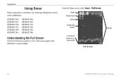
Using Sonar Using Sonar When connected to a transducer, the following chartplotters can be used as fishfinders: GPSMAP 430s GPSMAP 431s GPSMAP 530s GPSMAP 531s GPSMAP 540s GPSMAP 541s GPSMAP 440s GPSMAP 441s GPSMAP 535s GPSMAP 536s GPSMAP 545s GPSMAP 546s Understanding the Full Screen Select the Full Screen option to view a full-screen graph of the transducer's sonar readings. Depth Temperature Speed Suspended targets Transducer frequency or beam width Full Screen Range 50 GPSMAP 400/500 Series Owner's Manual From the Home screen, select Sonar > Full Screen.
Using Sonar Using Sonar When connected to a transducer, the following chartplotters can be used as fishfinders: GPSMAP 430s GPSMAP 431s GPSMAP 530s GPSMAP 531s GPSMAP 540s GPSMAP 541s GPSMAP 440s GPSMAP 441s GPSMAP 535s GPSMAP 536s GPSMAP 545s GPSMAP 546s Understanding the Full Screen Select the Full Screen option to view a full-screen graph of the transducer's sonar readings. Depth Temperature Speed Suspended targets Transducer frequency or beam width Full Screen Range 50 GPSMAP 400/500 Series Owner's Manual From the Home screen, select Sonar > Full Screen.


