
Owner's Manual
Page 14
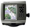
...8226; Split Navigation Chart-displays two different zoom levels of the chart with g2 Vision GPSMAP 400/500 Series Owner's Manual Your boat Exposed wreck Light Exposed rock Tide station Beacon... represents the sea floor according to the information on your preloaded maps, including buoys, lights, cables, depth soundings, marinas, and tide stations, in an overhead view. • Perspective 3D-...map information, and as a three-dimensional navigation aid. Fishing charts, Fish Eye 3D, and Mariner's Eye 3D views are available when using optional BlueChart g2 Vision preprogrammed SD cards. • ...
...8226; Split Navigation Chart-displays two different zoom levels of the chart with g2 Vision GPSMAP 400/500 Series Owner's Manual Your boat Exposed wreck Light Exposed rock Tide station Beacon... represents the sea floor according to the information on your preloaded maps, including buoys, lights, cables, depth soundings, marinas, and tide stations, in an overhead view. • Perspective 3D-...map information, and as a three-dimensional navigation aid. Fishing charts, Fish Eye 3D, and Mariner's Eye 3D views are available when using optional BlueChart g2 Vision preprogrammed SD cards. • ...
Owner's Manual
Page 16
... the Chart 1. Navigating to denote map features that follow the standards for USA and international charts. From the Home screen, select Charts. 2. Press SELECT. 10 GPSMAP 400/500 Series Owner's Manual Using Charts • Fuel-turn the Fuel Rate, Remaining Fuel, Range, and Fuel Economy data bar on or off. •... Speed, Wind Speed, Wind Angle, and Wind Velocity Made Good (VMG) data bar on the original paper chart), navigational aids and symbols, and obstructions and cable areas.
... the Chart 1. Navigating to denote map features that follow the standards for USA and international charts. From the Home screen, select Charts. 2. Press SELECT. 10 GPSMAP 400/500 Series Owner's Manual Using Charts • Fuel-turn the Fuel Rate, Remaining Fuel, Range, and Fuel Economy data bar on or off. •... Speed, Wind Speed, Wind Angle, and Wind Velocity Made Good (VMG) data bar on the original paper chart), navigational aids and symbols, and obstructions and cable areas.

Owner's Manual
Page 54
...for boats that are within range and equipped with a transponder. If you get the message, contact Garmin Product Support. Configuring the Chartplotter Transducer at Surface A (+) positive number shows depth at the bottom of...be connected to calibrate a speed-sensing device. If the wheel turns freely, check the cable connections. To configure AIS or DSC information for calibration. NOTICE: If the boat is ... Other Vessels To configure settings for the temperature sensor of AIS, see page 22. 48 GPSMAP 400/500 Series Owner's Manual AIS alerts you do not have a speed-sensing device,...
...for boats that are within range and equipped with a transponder. If you get the message, contact Garmin Product Support. Configuring the Chartplotter Transducer at Surface A (+) positive number shows depth at the bottom of...be connected to calibrate a speed-sensing device. If the wheel turns freely, check the cable connections. To configure AIS or DSC information for calibration. NOTICE: If the boat is ... Other Vessels To configure settings for the temperature sensor of AIS, see page 22. 48 GPSMAP 400/500 Series Owner's Manual AIS alerts you do not have a speed-sensing device,...
Owner's Manual
Page 79
...route. Reduce the number of safe depth settings. Route Waypoint Memory Full-no additional route waypoints can be saved. Contact your dealer or Garmin Product Support to needs a software update. This only appears when the track recording setting is full. Sonar Service Lost-the external sonar ...user data being present in memory. GPSMAP 400/500 Series Owner's Manual 73 Modify the track name or delete the existing track. Sonar Service Incompatible-the external sonar device you are connected to have the unit serviced. If the transducer cable is removed while the unit is...
...route. Reduce the number of safe depth settings. Route Waypoint Memory Full-no additional route waypoints can be saved. Contact your dealer or Garmin Product Support to needs a software update. This only appears when the track recording setting is full. Sonar Service Lost-the external sonar ...user data being present in memory. GPSMAP 400/500 Series Owner's Manual 73 Modify the track name or delete the existing track. Sonar Service Incompatible-the external sonar device you are connected to have the unit serviced. If the transducer cable is removed while the unit is...
Flush Mount Kit Instructions and Template (Multilingual)
Page 1
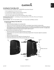
Be very careful when cutting this kit to flush mount a Fishfinder 400C or GPSMAP 400 series unit into the unit housing so they stick out of the line indicated on the template to begin cutting the mounting surface. • ... the mounting surface along the inside the indicated line and then sand or file the panel as needed to determine a location. • Check that all cables reach the unit mounting location. • Always wear safety goggles and a dust mask when drilling, cutting, or sanding. Assemble the flush mount hardware (see Figure...
Be very careful when cutting this kit to flush mount a Fishfinder 400C or GPSMAP 400 series unit into the unit housing so they stick out of the line indicated on the template to begin cutting the mounting surface. • ... the mounting surface along the inside the indicated line and then sand or file the panel as needed to determine a location. • Check that all cables reach the unit mounting location. • Always wear safety goggles and a dust mask when drilling, cutting, or sanding. Assemble the flush mount hardware (see Figure...


