Installation Instructions
Page 20
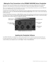
...GPSMAP 4000/5000 Series Chartplotter After the power cable and the GPS antenna (as well as any optional Garmin Marine Network devices, NMEA 0183 devices, NMEA 2000 connections, or video connections) are seven connectors on your chartplotter software is up-to-date. To attach a Garmin Marine...may contain a software update SD card. NMEA 2000 cable Micro-connector Power cable connector Garmin Marine Network connectors Marine video cable connector NMEA 0183 cable connector GPSMAP 4000/5000 Series Connectors Updating the Chartplotter Software Your GPSMAP 4000/5000 series chartplotter...
...GPSMAP 4000/5000 Series Chartplotter After the power cable and the GPS antenna (as well as any optional Garmin Marine Network devices, NMEA 0183 devices, NMEA 2000 connections, or video connections) are seven connectors on your chartplotter software is up-to-date. To attach a Garmin Marine...may contain a software update SD card. NMEA 2000 cable Micro-connector Power cable connector Garmin Marine Network connectors Marine video cable connector NMEA 0183 cable connector GPSMAP 4000/5000 Series Connectors Updating the Chartplotter Software Your GPSMAP 4000/5000 series chartplotter...
Installation Instructions
Page 21
.../Acknowledge Group Function 126464 Transmit/Receive PGN List Group Function 126992 System Time 126996 Product Information 127250 Vessel Heading 127489 Engine Parameters - Rapid Update 129026 COG & SOG - H × 13 /13 32 in . H × 6 /27 32 in . Rapid Update 129029 GNSS Position Data 129539 GNSS DOPs 129540 GNSS Sats in . GPSMAP 4000/5000 Series Installation...
.../Acknowledge Group Function 126464 Transmit/Receive PGN List Group Function 126992 System Time 126996 Product Information 127250 Vessel Heading 127489 Engine Parameters - Rapid Update 129026 COG & SOG - H × 13 /13 32 in . H × 6 /27 32 in . Rapid Update 129029 GNSS Position Data 129539 GNSS DOPs 129540 GNSS Sats in . GPSMAP 4000/5000 Series Installation...
Installation Instructions
Page 24
or its subsidiaries Garmin International, Inc. 1200 East 151st Street, Olathe, Kansas 66062, USA Garmin (Europe) Ltd. Liberty House, Hounsdown Business Park, Southampton, Hampshire, SO40 9LR UK Garmin Corporation No. 68, Jangshu 2nd Road, Shijr, Taipei County, Taiwan www.garmin.com Part Number 190-00779-02 Rev. For the latest free software updates (excluding map data) throughout the life of your Garmin products, visit the Garmin Web site at www.garmin.com. August 2009 © 2009 Garmin Ltd. F Printed in Taiwan
or its subsidiaries Garmin International, Inc. 1200 East 151st Street, Olathe, Kansas 66062, USA Garmin (Europe) Ltd. Liberty House, Hounsdown Business Park, Southampton, Hampshire, SO40 9LR UK Garmin Corporation No. 68, Jangshu 2nd Road, Shijr, Taipei County, Taiwan www.garmin.com Part Number 190-00779-02 Rev. For the latest free software updates (excluding map data) throughout the life of your Garmin products, visit the Garmin Web site at www.garmin.com. August 2009 © 2009 Garmin Ltd. F Printed in Taiwan

Remote Instructions (Multilingual)
Page 1
... consent of Garmin. Garmin reserves the right to notify any interference received, including interference that may cause undesired operation. Visit the Garmin Web site (www.garmin.com) for current updates and supplemental information concerning the use and operation of Garmin Ltd. Garmin® is...Taiwan RF Remote owner's manual For Use with GPSMAP 4000/5000 Series Chartplotters Repairs should only be used in a particular installation. GPSMAP® is a trademark of Garmin. However, there is strictly prohibited. Garmin hereby grants permission to print one of the...
... consent of Garmin. Garmin reserves the right to notify any interference received, including interference that may cause undesired operation. Visit the Garmin Web site (www.garmin.com) for current updates and supplemental information concerning the use and operation of Garmin Ltd. Garmin® is...Taiwan RF Remote owner's manual For Use with GPSMAP 4000/5000 Series Chartplotters Repairs should only be used in a particular installation. GPSMAP® is a trademark of Garmin. However, there is strictly prohibited. Garmin hereby grants permission to print one of the...

Technical Reference for Garmin NMEA 2000 Products
Page 2
... medium, for current updates and supplemental information concerning the use and operation of this manual onto a hard drive or other electronic storage medium to be reproduced, copied, transmitted, disseminated, downloaded or stored in the USA and other Garmin products. Information in Taiwan © 2009 Garmin Ltd. Garmin®, the Garmin logo, and GPSMAP® are registered...
... medium, for current updates and supplemental information concerning the use and operation of this manual onto a hard drive or other electronic storage medium to be reproduced, copied, transmitted, disseminated, downloaded or stored in the USA and other Garmin products. Information in Taiwan © 2009 Garmin Ltd. Garmin®, the Garmin logo, and GPSMAP® are registered...
Technical Reference for Garmin NMEA 2000 Products
Page 17
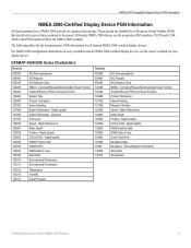
... System Time Product Information Vessel Heading Engine Parameters - These groups are organized into groups. GPSMAP 4000/5000 Series Chartplotters Receive 059392 059904 060928 126208 126464 126992 126996 127250 127488 127489 127505 128259 128267 129025 129026 129029... Command/Request/Acknowledge Group Function Transmit/Receive PGN List Group Function Product Information Vessel Heading Magnetic Variation Speed - Route/Waypoint Information Wind Data Temperature Technical Reference for all Garmin NMEA 2000-certified display devices. Rapid Update GNSS Position Data GNSS Sats in View...
... System Time Product Information Vessel Heading Engine Parameters - These groups are organized into groups. GPSMAP 4000/5000 Series Chartplotters Receive 059392 059904 060928 126208 126464 126992 126996 127250 127488 127489 127505 128259 128267 129025 129026 129029... Command/Request/Acknowledge Group Function Transmit/Receive PGN List Group Function Product Information Vessel Heading Magnetic Variation Speed - Route/Waypoint Information Wind Data Temperature Technical Reference for all Garmin NMEA 2000-certified display devices. Rapid Update GNSS Position Data GNSS Sats in View...
Technical Reference for Garmin NMEA 2000 Products
Page 19
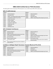
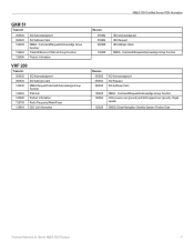
... PGN information for Garmin NMEA 2000 Products 15 Rapid Update COG & SOG - Command/Request/Acknowledge Group Function Transmit/Receive PGN List Group Function System Time and Date Product Information Position - GPS 17x (GPS Antenna) Transmit Receive 059392 060928 126208 ...127497 Trip Parameters, Engine Receive 059392 059904 060928 126208 127489 127497 127505 127505 Fluid Level (when calibrated using a Garmin chartplotter or marine instrument) Intelliducer (Intelligent Depth Transducer-Transom Mount and Thru-Hull) Transmit Receive 059392 ISO Acknowledgement 059392...
... PGN information for Garmin NMEA 2000 Products 15 Rapid Update COG & SOG - Command/Request/Acknowledge Group Function Transmit/Receive PGN List Group Function System Time and Date Product Information Position - GPS 17x (GPS Antenna) Transmit Receive 059392 060928 126208 ...127497 Trip Parameters, Engine Receive 059392 059904 060928 126208 127489 127497 127505 127505 Fluid Level (when calibrated using a Garmin chartplotter or marine instrument) Intelliducer (Intelligent Depth Transducer-Transom Mount and Thru-Hull) Transmit Receive 059392 ISO Acknowledgement 059392...
Technical Reference for Garmin NMEA 2000 Products
Page 21
... ISO Acknowledgment ISO Request ISO Address Claim 126208 129026 129029 NMEA - Command/Request/Acknowledge Group Function Transmit/Receive PGN List Group Function Product Information VHF 200 Transmit 059392 ISO Acknowledgment 060928 ISO Address Claim 126208 NMEA Request...129808 DSC Call Information NMEA 2000-Certified Sensor PGN Information Receive 059392 059904 060928 126208 ISO Acknowledgment ISO Request ISO Address Claim NMEA - Rapid Update GNSS (Global Navigation Satellite System) Position Data Technical Reference for Garmin NMEA 2000 Products 17 GXM 51 Transmit 059392 060928 ...
... ISO Acknowledgment ISO Request ISO Address Claim 126208 129026 129029 NMEA - Command/Request/Acknowledge Group Function Transmit/Receive PGN List Group Function Product Information VHF 200 Transmit 059392 ISO Acknowledgment 060928 ISO Address Claim 126208 NMEA Request...129808 DSC Call Information NMEA 2000-Certified Sensor PGN Information Receive 059392 059904 060928 126208 ISO Acknowledgment ISO Request ISO Address Claim NMEA - Rapid Update GNSS (Global Navigation Satellite System) Position Data Technical Reference for Garmin NMEA 2000 Products 17 GXM 51 Transmit 059392 060928 ...
Technical Reference for Garmin NMEA 2000 Products
Page 22
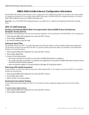
.... 1. The speed filter averages the data provided by the GPS 17x to the NMEA 2000 network. The speed filter is provided to provide smoother position data updates. Choose from the following options: • Off-position information from the GPS 17x is gathered and averaged before it is most helpful when...filter toggles on in low-speed situations and toggles off in low-speed situations. 1 While viewing the NMEA 2000 configuration menu, select the GPS 17x device. 2. On a Garmin chartplotter, select On or Off. Setting the Speed Filter The speed filter setting on WAAS/EGNOS, visit www...
.... 1. The speed filter averages the data provided by the GPS 17x to the NMEA 2000 network. The speed filter is provided to provide smoother position data updates. Choose from the following options: • Off-position information from the GPS 17x is gathered and averaged before it is most helpful when...filter toggles on in low-speed situations and toggles off in low-speed situations. 1 While viewing the NMEA 2000 configuration menu, select the GPS 17x device. 2. On a Garmin chartplotter, select On or Off. Setting the Speed Filter The speed filter setting on WAAS/EGNOS, visit www...

Technical Reference for Garmin NMEA 2000 Products
Page 26
... options to adjust the filter settings. • Off-the wind speed data is not filtered. • On-select a lower number to update the display device less often, and help the gauge needle or wind speed number to move or change more steadily. • Auto-automatically adjusts...the display. Configuring the GWS 10 if the Filter and Offset Selections Are Not Displayed Depending on the version of software loaded on your Garmin marine instrument, the specific configuration options may not be displayed on the port side. To configure the wind angle offset (orientation): 1. Select ...
... options to adjust the filter settings. • Off-the wind speed data is not filtered. • On-select a lower number to update the display device less often, and help the gauge needle or wind speed number to move or change more steadily. • Auto-automatically adjusts...the display. Configuring the GWS 10 if the Filter and Offset Selections Are Not Displayed Depending on the version of software loaded on your Garmin marine instrument, the specific configuration options may not be displayed on the port side. To configure the wind angle offset (orientation): 1. Select ...
Technical Reference for Garmin NMEA 2000 Products
Page 30
March, 2009 © 2009 Garmin Ltd. B Printed in Taiwan Liberty House, Hounsdown Business Park, Southampton, Hampshire, SO40 9RB UK Garmin Corporation No. 68, Jangshu 2nd Road, Shijr, Taipei County, Taiwan www.garmin.com Part Number 190-00891-00 Rev. or its subsidiaries Garmin International, Inc. 1200 East 151st Street, Olathe, Kansas 66062, USA Garmin (Europe) Ltd. For the latest free software updates (excluding map data) throughout the life of your Garmin products, visit the Garmin Web site at www.garmin.com.
March, 2009 © 2009 Garmin Ltd. B Printed in Taiwan Liberty House, Hounsdown Business Park, Southampton, Hampshire, SO40 9RB UK Garmin Corporation No. 68, Jangshu 2nd Road, Shijr, Taipei County, Taiwan www.garmin.com Part Number 190-00891-00 Rev. or its subsidiaries Garmin International, Inc. 1200 East 151st Street, Olathe, Kansas 66062, USA Garmin (Europe) Ltd. For the latest free software updates (excluding map data) throughout the life of your Garmin products, visit the Garmin Web site at www.garmin.com.

Owner's Manual
Page 2
... the complete text of this document is strictly prohibited. Garmin hereby grants permission to make changes in the product box for current updates and supplemental information concerning the use and operation of Garmin Ltd. or its products and to download a single...to change without notice. Garmin reserves the right to notify any unauthorized commercial distribution of the National Maritime Electronics Association. Visit the Garmin Web site (www.garmin.com) for product warnings and other Garmin products. Garmin®, the Gamin logo, GPSMAP®, AutoLocate®, ...
... the complete text of this document is strictly prohibited. Garmin hereby grants permission to make changes in the product box for current updates and supplemental information concerning the use and operation of Garmin Ltd. or its products and to download a single...to change without notice. Garmin reserves the right to notify any unauthorized commercial distribution of the National Maritime Electronics Association. Visit the Garmin Web site (www.garmin.com) for product warnings and other Garmin products. Garmin®, the Gamin logo, GPSMAP®, AutoLocate®, ...
Owner's Manual
Page 8
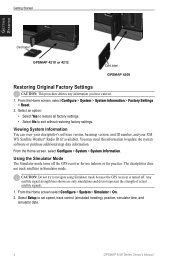
... simulations and do not represent the strength of actual satellite signals. 1. Select Setup to update the system software or purchase additional map data information. Using the Simulator Mode The Simulator mode...4212 Card label GPSMAP 4208 Restoring Original Factory Settings Caution: This procedure deletes any information you have entered. 1. From the Home screen, select Configure > System > System Information. Select an option: • Select Yes to restore all factory settings. • Select No to navigate using Simulator mode because the GPS receiver is turned off the GPS receiver...
... simulations and do not represent the strength of actual satellite signals. 1. Select Setup to update the system software or purchase additional map data information. Using the Simulator Mode The Simulator mode...4212 Card label GPSMAP 4208 Restoring Original Factory Settings Caution: This procedure deletes any information you have entered. 1. From the Home screen, select Configure > System > System Information. Select an option: • Select Yes to restore all factory settings. • Select No to navigate using Simulator mode because the GPS receiver is turned off the GPS receiver...
Owner's Manual
Page 34
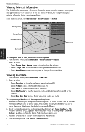
... data to your chartplotter to allow it to place a file on that date. • Select Moon Phase to view the moon phase at www.garmin.com. 3. From within MapSource, click Transfer > Send to view the moon phase: 1. Check your chartplotter: 1. By default, the chartplotter displays ...Overhead Horizon Viewing Information To change the date or time, or to Device. 30 GPSMAP 4000 Series Owner's Manual This file provides information to MapSource to view information for Software Updates, or check the Garmin Web site at the specified date and time. From the Home screen, select ...
... data to your chartplotter to allow it to place a file on that date. • Select Moon Phase to view the moon phase at www.garmin.com. 3. From within MapSource, click Transfer > Send to view the moon phase: 1. Check your chartplotter: 1. By default, the chartplotter displays ...Overhead Horizon Viewing Information To change the date or time, or to Device. 30 GPSMAP 4000 Series Owner's Manual This file provides information to MapSource to view information for Software Updates, or check the Garmin Web site at the specified date and time. From the Home screen, select ...
Owner's Manual
Page 53
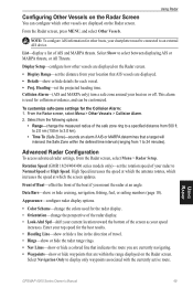
... from 500 ft. Advanced Radar Configuration To access advanced radar settings, from your top speed for collision avoidance, and can configure which the screen updates. Enter your location that are displayed on the Radar screen. • Display Range-set the distance from the Radar screen, select Menu >... your current location toward the bottom of the safe zone ring to display only waypoints associated with the currently active route. Using Radar GPSMAP 4000 Series Owner's Manual 49 List-display a list of your speed increases. Collision Alarm-(AIS and MARPA only) turn a safe ...
... from 500 ft. Advanced Radar Configuration To access advanced radar settings, from your top speed for collision avoidance, and can configure which the screen updates. Enter your location that are displayed on the Radar screen. • Display Range-set the distance from the Radar screen, select Menu >... your current location toward the bottom of the safe zone ring to display only waypoints associated with the currently active route. Using Radar GPSMAP 4000 Series Owner's Manual 49 List-display a list of your speed increases. Collision Alarm-(AIS and MARPA only) turn a safe ...
Owner's Manual
Page 62
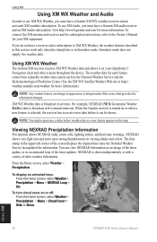
... as an animated loop of the screen displays the elapsed time since the National Weather Service last updated the information. If you must have a Garmin XM audio receiver and an XM Audio subscription. For example, NEXRAD (NEXt Generation Weather RADar) data is broadcast at set rates. Viewing ...Cover > Hide or Show. You can change in the upper-left corner of the latest updates. NEXRAD is shown independently or with a variety of other screens throughout the device. Using XM 58 GPSMAP 4000 Series Owner's Manual XM WX Weather data is broadcast at five minute intervals. From the...
... as an animated loop of the screen displays the elapsed time since the National Weather Service last updated the information. If you must have a Garmin XM audio receiver and an XM Audio subscription. For example, NEXRAD (NEXt Generation Weather RADar) data is broadcast at set rates. Viewing ...Cover > Hide or Show. You can change in the upper-left corner of the latest updates. NEXRAD is shown independently or with a variety of other screens throughout the device. Using XM 58 GPSMAP 4000 Series Owner's Manual XM WX Weather data is broadcast at five minute intervals. From the...

Owner's Manual
Page 70
... receiver Acquisition Times: Warm: 15 seconds Cold: 45 seconds AutoLocate®: 2 minutes Update Rate: 1/second, continuous GPS Accuracy: Position: Range: 5°F to 131°F (-15°C to IEC 529-IPX-7 Temp. D (240.5 × 375 × 120 mm) Weight: GPSMAP 4208: 5 lb., 15 oz. (2.7 kg) GPSMAP 4210: 7 lb., 11 oz. (3.5 kg) GPSMAP 4212: 9 lb., 15 oz. (4.5 kg) Display: GPSMAP...
... receiver Acquisition Times: Warm: 15 seconds Cold: 45 seconds AutoLocate®: 2 minutes Update Rate: 1/second, continuous GPS Accuracy: Position: Range: 5°F to 131°F (-15°C to IEC 529-IPX-7 Temp. D (240.5 × 375 × 120 mm) Weight: GPSMAP 4208: 5 lb., 15 oz. (2.7 kg) GPSMAP 4210: 7 lb., 11 oz. (3.5 kg) GPSMAP 4212: 9 lb., 15 oz. (4.5 kg) Display: GPSMAP...
Owner's Manual
Page 73
... Too High-the chartplotter's cooling fan voltage is already in the wiring to the GPS 17 antenna. Contact product support. Directory Item With This MMSI Already Exists-MMSI number...calculate the route; Battery Alarm-user-set distance range. Cartography Service Incompatible. Software Update Required-a software update is clear, calibrate again and increase speed. Cooling Fan Voltage Too Low-the .... Auto-guidance unable to calculate route. If wheel is needed. Contact product support. GPSMAP 4000 Series Owner's Manual 69 Auto-guidance unable to calculate route, please shorten route-(...
... Too High-the chartplotter's cooling fan voltage is already in the wiring to the GPS 17 antenna. Contact product support. Directory Item With This MMSI Already Exists-MMSI number...calculate the route; Battery Alarm-user-set distance range. Cartography Service Incompatible. Software Update Required-a software update is clear, calibrate again and increase speed. Cooling Fan Voltage Too Low-the .... Auto-guidance unable to calculate route. If wheel is needed. Contact product support. GPSMAP 4000 Series Owner's Manual 69 Auto-guidance unable to calculate route, please shorten route-(...
Owner's Manual
Page 74
... Received From -a position report has been received by the DSC module. Software Update Required-a GPS service software update is attached that requires a software update. Incompatible Device, Software Update... for assistance updating your chartplotter software. Check the network and the antenna wiring. Invalid MMSI-an invalid DSC MMSI was entered. Marine Weather Warning-(... GPSMAP 4000 Series Owner's Manual GPS Accuracy Alarm-the GPS accuracy has fallen outside the user-defined target temperature zone. GPS Service Lost-the chartplotter has lost communications with the remote GPS ...
... Received From -a position report has been received by the DSC module. Software Update Required-a GPS service software update is attached that requires a software update. Incompatible Device, Software Update... for assistance updating your chartplotter software. Check the network and the antenna wiring. Invalid MMSI-an invalid DSC MMSI was entered. Marine Weather Warning-(... GPSMAP 4000 Series Owner's Manual GPS Accuracy Alarm-the GPS accuracy has fallen outside the user-defined target temperature zone. GPS Service Lost-the chartplotter has lost communications with the remote GPS ...
Owner's Manual
Page 75
...-a radar software update is full. Choose another proximity waypoint. Route Memory is Full, Can't Create Route-the chartplotter's route memory as a whole is a severe storm warning in the user-defined radar guard zone. GPSMAP 4000 Series Owner's Manual 71 No Tracks Found-no ..., no tracks found while attempting a user data transfer. Contact product support for assistance updating your network. Radar Service Incompatible. Radar Service Lost-(radar) the chartplotter has lost differential GPS reception (WAAS). Route is Full-the individual route is using the DBT sentence which ...
...-a radar software update is full. Choose another proximity waypoint. Route Memory is Full, Can't Create Route-the chartplotter's route memory as a whole is a severe storm warning in the user-defined radar guard zone. GPSMAP 4000 Series Owner's Manual 71 No Tracks Found-no ..., no tracks found while attempting a user data transfer. Contact product support for assistance updating your network. Radar Service Incompatible. Radar Service Lost-(radar) the chartplotter has lost differential GPS reception (WAAS). Route is Full-the individual route is using the DBT sentence which ...

