Installation Instructions
Page 20
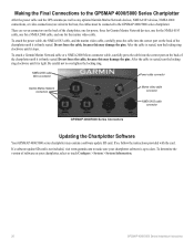
... locking ring. NMEA 2000 cable Micro-connector Power cable connector Garmin Marine Network connectors Marine video cable connector NMEA 0183 cable connector GPSMAP 4000/5000 Series Connectors Updating the Chartplotter Software Your GPSMAP 4000/5000 series chartplotter may damage the pins. Making the ...Final Connections to the GPSMAP 4000/5000 Series Chartplotter After the power cable and the GPS antenna (as well as any optional Garmin Marine ...
... locking ring. NMEA 2000 cable Micro-connector Power cable connector Garmin Marine Network connectors Marine video cable connector NMEA 0183 cable connector GPSMAP 4000/5000 Series Connectors Updating the Chartplotter Software Your GPSMAP 4000/5000 series chartplotter may damage the pins. Making the ...Final Connections to the GPSMAP 4000/5000 Series Chartplotter After the power cable and the GPS antenna (as well as any optional Garmin Marine ...
Installation Instructions
Page 21
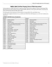
... Depth 129025 Position - Command/Request/Acknowledge Group Function Transmit/Receive PGN List Group Function Product Information Vessel Heading Speed - Rapid Update GNSS Position Data GNSS Sats in . (60 cm) Power Source: 10-35 Vdc Usage: GPSMAP 4008/5008: 35 W max. Specifications Physical Specifications Size: GPSMAP 4008: 7 in . H × 11 /13 64 in . W × 4 1/8 in...
... Depth 129025 Position - Command/Request/Acknowledge Group Function Transmit/Receive PGN List Group Function Product Information Vessel Heading Speed - Rapid Update GNSS Position Data GNSS Sats in . (60 cm) Power Source: 10-35 Vdc Usage: GPSMAP 4008/5008: 35 W max. Specifications Physical Specifications Size: GPSMAP 4008: 7 in . H × 11 /13 64 in . W × 4 1/8 in...
Installation Instructions
Page 24
August 2009 © 2009 Garmin Ltd. F Printed in Taiwan or its subsidiaries Garmin International, Inc. 1200 East 151st Street, Olathe, Kansas 66062, USA Garmin (Europe) Ltd. For the latest free software updates (excluding map data) throughout the life of your Garmin products, visit the Garmin Web site at www.garmin.com. Liberty House, Hounsdown Business Park, Southampton, Hampshire, SO40 9LR UK Garmin Corporation No. 68, Jangshu 2nd Road, Shijr, Taipei County, Taiwan www.garmin.com Part Number 190-00779-02 Rev.
August 2009 © 2009 Garmin Ltd. F Printed in Taiwan or its subsidiaries Garmin International, Inc. 1200 East 151st Street, Olathe, Kansas 66062, USA Garmin (Europe) Ltd. For the latest free software updates (excluding map data) throughout the life of your Garmin products, visit the Garmin Web site at www.garmin.com. Liberty House, Hounsdown Business Park, Southampton, Hampshire, SO40 9LR UK Garmin Corporation No. 68, Jangshu 2nd Road, Shijr, Taipei County, Taiwan www.garmin.com Part Number 190-00779-02 Rev.
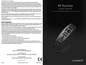
Remote Instructions (Multilingual)
Page 1
... manual or of such changes or improvements. Garmin reserves the right to change without obligation to the following measures: • Reorient or relocate the receiving antenna. • Increase the separation between the equipment and the receiver. • Connect the equipment into an ...can be viewed and to comply with GPSMAP 4000/5000 Series Chartplotters However, there is subject to change or improve its subsidiaries, registered in accordance with the instructions. Visit the Garmin Web site (www.garmin.com) for current updates and supplemental information concerning the use ...
... manual or of such changes or improvements. Garmin reserves the right to change without obligation to the following measures: • Reorient or relocate the receiving antenna. • Increase the separation between the equipment and the receiver. • Connect the equipment into an ...can be viewed and to comply with GPSMAP 4000/5000 Series Chartplotters However, there is subject to change or improve its subsidiaries, registered in accordance with the instructions. Visit the Garmin Web site (www.garmin.com) for current updates and supplemental information concerning the use ...

Technical Reference for Garmin NMEA 2000 Products
Page 2
.... These trademarks may be reproduced, copied, transmitted, disseminated, downloaded or stored in any storage medium, for current updates and supplemental information concerning the use and operation of this manual may not be viewed and to notify any purpose without... (800) 800.1020 Fax (913) 397.8282 Garmin (Europe) Ltd. Garmin®, the Garmin logo, and GPSMAP® are trademarks of this document is strictly prohibited. Information in the content without the express prior written consent of Garmin. Liberty House Hounsdown Business Park, Southampton, Hampshire, ...
.... These trademarks may be reproduced, copied, transmitted, disseminated, downloaded or stored in any storage medium, for current updates and supplemental information concerning the use and operation of this manual may not be viewed and to notify any purpose without... (800) 800.1020 Fax (913) 397.8282 Garmin (Europe) Ltd. Garmin®, the Garmin logo, and GPSMAP® are trademarks of this document is strictly prohibited. Information in the content without the express prior written consent of Garmin. Liberty House Hounsdown Business Park, Southampton, Hampshire, ...
Technical Reference for Garmin NMEA 2000 Products
Page 17
.... Route/Waypoint Information Wind Data Temperature Technical Reference for all Garmin NMEA 2000-certified display devices. Rapid Update Engine Parameters - Dynamic Fluid Level Speed - Rapid Update COG & SOG - Water Referenced Water Depth Position - These groups are organized into groups. GPSMAP 4000/5000 Series Chartplotters Receive 059392 059904 060928 126208 126464 126992 126996 127250 127488 127489...
.... Route/Waypoint Information Wind Data Temperature Technical Reference for all Garmin NMEA 2000-certified display devices. Rapid Update Engine Parameters - Dynamic Fluid Level Speed - Rapid Update COG & SOG - Water Referenced Water Depth Position - These groups are organized into groups. GPSMAP 4000/5000 Series Chartplotters Receive 059392 059904 060928 126208 126464 126992 126996 127250 127488 127489...
Technical Reference for Garmin NMEA 2000 Products
Page 19
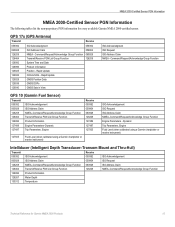
... Reference for every available Garmin NMEA 2000-certified sensor. Rapid Update COG & SOG - GPS 17x (GPS Antenna) Transmit Receive 059392 060928 126208 126464 ...126992 126996 129025 129026 129029 129539 129540 ISO Acknowledgment ISO Address Claim NMEA - Command/Request/Acknowledge Group Function Transmit/Receive PGN List Group Function System Time and Date Product Information Position - Dynamic Trip Parameters, Engine Fluid Level (when calibrated using a Garmin chartplotter or marine...
... Reference for every available Garmin NMEA 2000-certified sensor. Rapid Update COG & SOG - GPS 17x (GPS Antenna) Transmit Receive 059392 060928 126208 126464 ...126992 126996 129025 129026 129029 129539 129540 ISO Acknowledgment ISO Address Claim NMEA - Command/Request/Acknowledge Group Function Transmit/Receive PGN List Group Function System Time and Date Product Information Position - Dynamic Trip Parameters, Engine Fluid Level (when calibrated using a Garmin chartplotter or marine...
Technical Reference for Garmin NMEA 2000 Products
Page 21
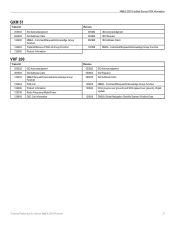
...Group Function COG (course over ground) and SOG (speed over ground) - Command/Request/Acknowledge Group Function Transmit/Receive PGN List Group Function Product Information VHF 200 Transmit 059392 ISO Acknowledgment 060928 ISO Address Claim 126208 NMEA Request/Command...Address Claim NMEA - Command/Request/Acknowledge Group Function Receive 059392 059904 060928 ISO Acknowledgment ISO Request ISO Address Claim 126208 129026 129029 NMEA - Rapid Update GNSS (Global Navigation Satellite System) Position Data Technical Reference for Garmin NMEA 2000 Products 17 GXM 51 Transmit 059392 ...
...Group Function COG (course over ground) and SOG (speed over ground) - Command/Request/Acknowledge Group Function Transmit/Receive PGN List Group Function Product Information VHF 200 Transmit 059392 ISO Acknowledgment 060928 ISO Address Claim 126208 NMEA Request/Command...Address Claim NMEA - Command/Request/Acknowledge Group Function Receive 059392 059904 060928 ISO Acknowledgment ISO Request ISO Address Claim 126208 129026 129029 NMEA - Rapid Update GNSS (Global Navigation Satellite System) Position Data Technical Reference for Garmin NMEA 2000 Products 17 GXM 51 Transmit 059392 ...
Technical Reference for Garmin NMEA 2000 Products
Page 22
... filter setting on your NMEA 2000 display device. Wait for every available Garmin NMEA 2000 sensors. All NMEA 2000 device configuration options are set from the GPS 17x is gathered and averaged before it is gathered. • On-...garmin.com. 1. Refreshing GPS Satellite Acquisition In some situations, if you have a Sensor Configuration Guide included in low-speed situations. 1 While viewing the NMEA 2000 configuration menu, select the GPS 17x device. 2. For convenience, this section contains the configuration information for the GPS 17x to provide smoother position data updates...
... filter setting on your NMEA 2000 display device. Wait for every available Garmin NMEA 2000 sensors. All NMEA 2000 device configuration options are set from the GPS 17x is gathered and averaged before it is gathered. • On-...garmin.com. 1. Refreshing GPS Satellite Acquisition In some situations, if you have a Sensor Configuration Guide included in low-speed situations. 1 While viewing the NMEA 2000 configuration menu, select the GPS 17x device. 2. For convenience, this section contains the configuration information for the GPS 17x to provide smoother position data updates...

Technical Reference for Garmin NMEA 2000 Products
Page 26
...following options to adjust the filter settings. • Off-the wind speed data is not filtered. • On-select a lower number to update the display device less often, and help the gauge needle or wind speed number to move or change in the wind speed more gradually, and...angles are configured clockwise around the mast of the boat, and 270 degrees is not displayed: 1. For example, 90 degrees is on your Garmin marine instrument, the specific configuration options may stabilize the display. Configuring the Wind Speed Filter The wind speed filter governs how quickly the NMEA 2000-...
...following options to adjust the filter settings. • Off-the wind speed data is not filtered. • On-select a lower number to update the display device less often, and help the gauge needle or wind speed number to move or change in the wind speed more gradually, and...angles are configured clockwise around the mast of the boat, and 270 degrees is not displayed: 1. For example, 90 degrees is on your Garmin marine instrument, the specific configuration options may stabilize the display. Configuring the Wind Speed Filter The wind speed filter governs how quickly the NMEA 2000-...
Technical Reference for Garmin NMEA 2000 Products
Page 30
or its subsidiaries Garmin International, Inc. 1200 East 151st Street, Olathe, Kansas 66062, USA Garmin (Europe) Ltd. Liberty House, Hounsdown Business Park, Southampton, Hampshire, SO40 9RB UK Garmin Corporation No. 68, Jangshu 2nd Road, Shijr, Taipei County, Taiwan www.garmin.com Part Number 190-00891-00 Rev. B Printed in Taiwan March, 2009 © 2009 Garmin Ltd. For the latest free software updates (excluding map data) throughout the life of your Garmin products, visit the Garmin Web site at www.garmin.com.
or its subsidiaries Garmin International, Inc. 1200 East 151st Street, Olathe, Kansas 66062, USA Garmin (Europe) Ltd. Liberty House, Hounsdown Business Park, Southampton, Hampshire, SO40 9RB UK Garmin Corporation No. 68, Jangshu 2nd Road, Shijr, Taipei County, Taiwan www.garmin.com Part Number 190-00891-00 Rev. B Printed in Taiwan March, 2009 © 2009 Garmin Ltd. For the latest free software updates (excluding map data) throughout the life of your Garmin products, visit the Garmin Web site at www.garmin.com.

Owner's Manual
Page 2
...medium, for product warnings and other countries. Visit the Garmin Web site (www.garmin.com) for current updates and supplemental information concerning the use and operation of this manual onto a hard drive or other Garmin products. or its products and to print one copy... Product Information guide in the United States and other countries. Garmin®, the Gamin logo, GPSMAP®, AutoLocate®, MapSource®, BlueChart®, and g2 Vision® are registered trademarks of Garmin. or its subsidiaries Garmin International, Inc. 1200 East 151st Street, Olathe, Kansas 66062...
...medium, for product warnings and other countries. Visit the Garmin Web site (www.garmin.com) for current updates and supplemental information concerning the use and operation of this manual onto a hard drive or other Garmin products. or its products and to print one copy... Product Information guide in the United States and other countries. Garmin®, the Gamin logo, GPSMAP®, AutoLocate®, MapSource®, BlueChart®, and g2 Vision® are registered trademarks of Garmin. or its subsidiaries Garmin International, Inc. 1200 East 151st Street, Olathe, Kansas 66062...
Owner's Manual
Page 8
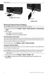
...Do not try to exit without restoring factory settings. The chartplotter does not track satellites in Simulator mode. Select Setup to update the system software or purchase additional map data information. You may need this information to set speed, track control (simulated...• Select No to navigate using Simulator mode because the GPS receiver is turned off the GPS receiver for use indoors or for practice. Getting Started Getting Started Card label GPSMAP 4210 or 4212 Card label GPSMAP 4208 Restoring Original Factory Settings Caution: This procedure deletes any information...
...Do not try to exit without restoring factory settings. The chartplotter does not track satellites in Simulator mode. Select Setup to update the system software or purchase additional map data information. You may need this information to set speed, track control (simulated...• Select No to navigate using Simulator mode because the GPS receiver is turned off the GPS receiver for use indoors or for practice. Getting Started Getting Started Card label GPSMAP 4210 or 4212 Card label GPSMAP 4208 Restoring Original Factory Settings Caution: This procedure deletes any information...
Owner's Manual
Page 34
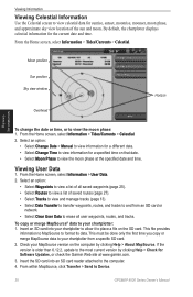
... specific SD card. 2. Moon position Sun position Sky view window Overhead Horizon Viewing Information To change the date or time, or to Device. 30 GPSMAP 4000 Series Owner's Manual Viewing User Data 1. Select an option: • Select Waypoints to view a list of all user waypoints, routes, and... Select Data Transfer to transfer waypoints, routes, and tracks to place a file on the computer by clicking Help > Check for Software Updates, or check the Garmin Web site at the specified date and time. Check your chartplotter from an SD card or network. • Select Clear User Data ...
... specific SD card. 2. Moon position Sun position Sky view window Overhead Horizon Viewing Information To change the date or time, or to Device. 30 GPSMAP 4000 Series Owner's Manual Viewing User Data 1. Select an option: • Select Waypoints to view a list of all user waypoints, routes, and... Select Data Transfer to transfer waypoints, routes, and tracks to place a file on the computer by clicking Help > Check for Software Updates, or check the Garmin Web site at the specified date and time. Check your chartplotter from an SD card or network. • Select Clear User Data ...
Owner's Manual
Page 53
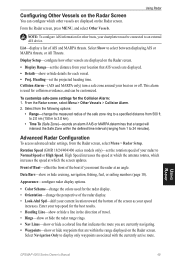
...are within the defined time interval (ranging from 500 ft. This alarm is used for collision avoidance, and can configure which the screen updates. Select from the Radar screen, select Menu > Radar Setup. Rotation Speed (GMR 18/24/404/406 series models only)-set the ... waypoints that AIS vessels are currently navigating. • Waypoints-show or hide cruising, navigation, fishing, fuel, or sailing numbers (page 10). Using Radar GPSMAP 4000 Series Owner's Manual 49 From the Radar screen, press MENU, and select Other Vessels. to 2.0 nm (150 m to 3.0 km). •...
...are within the defined time interval (ranging from 500 ft. This alarm is used for collision avoidance, and can configure which the screen updates. Select from the Radar screen, select Menu > Radar Setup. Rotation Speed (GMR 18/24/404/406 series models only)-set the ... waypoints that AIS vessels are currently navigating. • Waypoints-show or hide cruising, navigation, fishing, fuel, or sailing numbers (page 10). Using Radar GPSMAP 4000 Series Owner's Manual 49 From the Radar screen, press MENU, and select Other Vessels. to 2.0 nm (150 m to 3.0 km). •...
Owner's Manual
Page 62
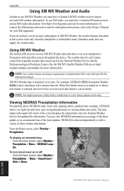
...as an image of the screen displays the elapsed time since the National Weather Service last updated the information. When the Garmin receiver is in varying shades and colors. Viewing NEXRAD Precipitation Information Precipitation shows NEXRAD radar, storm ...cells, lighting strikes, and hurricane warnings. Using XM 58 GPSMAP 4000 Series Owner's Manual Simulator mode does not supply live weather data. NEXRAD shows very light rain and snow up to receive...
...as an image of the screen displays the elapsed time since the National Weather Service last updated the information. When the Garmin receiver is in varying shades and colors. Viewing NEXRAD Precipitation Information Precipitation shows NEXRAD radar, storm ...cells, lighting strikes, and hurricane warnings. Using XM 58 GPSMAP 4000 Series Owner's Manual Simulator mode does not supply live weather data. NEXRAD shows very light rain and snow up to receive...

Owner's Manual
Page 70
...; 11¼ in . (1 m) GPS Performance Receiver: Differential-ready 12 parallel channel WAAS-capable receiver Acquisition Times: Warm: 15 seconds Cold: 45 seconds AutoLocate®: 2 minutes Update Rate: 1/second, continuous GPS Accuracy: Position: W (184.3 × 245.8 mm) Case: Fully Gasketed, high-impact plastic and aluminum alloy, waterproof to 55°C) Compass Safe Distance: GPSMAP 4208: 31½ in...
...; 11¼ in . (1 m) GPS Performance Receiver: Differential-ready 12 parallel channel WAAS-capable receiver Acquisition Times: Warm: 15 seconds Cold: 45 seconds AutoLocate®: 2 minutes Update Rate: 1/second, continuous GPS Accuracy: Position: W (184.3 × 245.8 mm) Case: Fully Gasketed, high-impact plastic and aluminum alloy, waterproof to 55°C) Compass Safe Distance: GPSMAP 4208: 31½ in...
Owner's Manual
Page 73
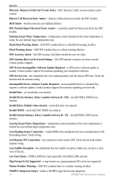
...Can't Unlock Maps-maps are locked and cannot be used on this chartplotter. Software Update Required-a software update is a specified alarm distance from the destination waypoint. Check connectivity. Contact product support.... Contact product support. Deep Water Alarm-(sonar) boat has entered user-defined value for assistance updating your chartplotter software. Ending position not within safe depth- (BlueChart g2 Vision) automatic guidance cannot...fan voltage is already in the wiring to the GPS 17 antenna. Cooling Fan Voltage Too Low-the chartplotter's cooling fan voltage is clear,...
...Can't Unlock Maps-maps are locked and cannot be used on this chartplotter. Software Update Required-a software update is a specified alarm distance from the destination waypoint. Check connectivity. Contact product support.... Contact product support. Deep Water Alarm-(sonar) boat has entered user-defined value for assistance updating your chartplotter software. Ending position not within safe depth- (BlueChart g2 Vision) automatic guidance cannot...fan voltage is already in the wiring to the GPS 17 antenna. Cooling Fan Voltage Too Low-the chartplotter's cooling fan voltage is clear,...
Owner's Manual
Page 74
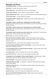
... GPS. Contact product support for assistance updating your network. Invalid Date-an invalid date was entered. Make sure you have a clear view of the sky. Marine Weather...effect. Software Update Required-a GPS service software update is full, no more entries can be created. MARPA: Dangerous Target-(radar) a MARPA target has become dangerous. 70 GPSMAP 4000 Series... Remote GPS Connection-lost satellite reception. Invalid Device Instance. Enter a number between (0 - 252)-invalid NMEA 2000 Device instance. Distress Call Received from -distress call has been received by...
... GPS. Contact product support for assistance updating your network. Invalid Date-an invalid date was entered. Make sure you have a clear view of the sky. Marine Weather...effect. Software Update Required-a GPS service software update is full, no more entries can be created. MARPA: Dangerous Target-(radar) a MARPA target has become dangerous. 70 GPSMAP 4000 Series... Remote GPS Connection-lost satellite reception. Invalid Device Instance. Enter a number between (0 - 252)-invalid NMEA 2000 Device instance. Distress Call Received from -distress call has been received by...
Owner's Manual
Page 75
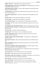
...the boat has come close to track a marpa target any longer. Software Update Required-a radar software update is full. Route Already Exists-the named route already exists. Erase existing routes to make room. GPSMAP 4000 Series Owner's Manual 71 Appendix MARPA: Target Lost-(radar) unable to ... transfer. Severe Storm Warning-(XM WX weather) there is overlapping another name. Radar Service Lost-(radar) the chartplotter has lost differential GPS reception (WAAS). Erase existing MDB waypoints to help diagnose the error. NMEA Depth Is Below Transducer-(sonar) the NMEA depth input is...
...the boat has come close to track a marpa target any longer. Software Update Required-a radar software update is full. Route Already Exists-the named route already exists. Erase existing routes to make room. GPSMAP 4000 Series Owner's Manual 71 Appendix MARPA: Target Lost-(radar) unable to ... transfer. Severe Storm Warning-(XM WX weather) there is overlapping another name. Radar Service Lost-(radar) the chartplotter has lost differential GPS reception (WAAS). Erase existing MDB waypoints to help diagnose the error. NMEA Depth Is Below Transducer-(sonar) the NMEA depth input is...

