Important Safety and Product Information
Page 1
... input capability. Official government charts and notices to mariners contain all information needed to all available navigation sources, including information from visual sightings, local waterway rules and restrictions, and maps. See www.garmin.com/prop65 for any discrepancies or questions before continuing... navigation. • Use the electronic chart in property damage, serious injury, or death. Operating or watching the video input while the boat is...
... input capability. Official government charts and notices to mariners contain all information needed to all available navigation sources, including information from visual sightings, local waterway rules and restrictions, and maps. See www.garmin.com/prop65 for any discrepancies or questions before continuing... navigation. • Use the electronic chart in property damage, serious injury, or death. Operating or watching the video input while the boat is...
Installation Instructions
Page 1
... the display and easy operation of a professional installer; The holes on the mounting hardware chosen. Because of the surface. The size of two ways. GPSMAP® 4000/5000 Series Installation Instructions The GPSMAP 4000/5000 series chartplotter and GPS antenna must be properly ...mount are not included. at 44/0870.8501241. Mounting the GPSMAP 4000/5000 Series Chartplotter You can use the GPSMAP 4000/5000 chartplotter, this manual covers other installation options: • Connecting the chartplotter to other Garmin Marine Network compatible devices, such as a VHF radio with DSC...
... the display and easy operation of a professional installer; The holes on the mounting hardware chosen. Because of the surface. The size of two ways. GPSMAP® 4000/5000 Series Installation Instructions The GPSMAP 4000/5000 series chartplotter and GPS antenna must be properly ...mount are not included. at 44/0870.8501241. Mounting the GPSMAP 4000/5000 Series Chartplotter You can use the GPSMAP 4000/5000 chartplotter, this manual covers other installation options: • Connecting the chartplotter to other Garmin Marine Network compatible devices, such as a VHF radio with DSC...
Remote Instructions (Multilingual)
Page 1
... this manual may be determined by turning the equipment off and on a different circuit from the GPS unit. • Consult the dealer or an experienced radio/TV technician for current updates and supplemental information concerning the use and operation of this and other Garmin products....change or improve its subsidiaries, registered in Taiwan RF Remote owner's manual For Use with GPSMAP 4000/5000 Series Chartplotters © 2007 Garmin Ltd. Garmin hereby grants permission to download a single copy of this manual onto a hard drive or other countries. This product does not ...
... this manual may be determined by turning the equipment off and on a different circuit from the GPS unit. • Consult the dealer or an experienced radio/TV technician for current updates and supplemental information concerning the use and operation of this and other Garmin products....change or improve its subsidiaries, registered in Taiwan RF Remote owner's manual For Use with GPSMAP 4000/5000 Series Chartplotters © 2007 Garmin Ltd. Garmin hereby grants permission to download a single copy of this manual onto a hard drive or other countries. This product does not ...

Technical Reference for Garmin NMEA 2000 Products
Page 2
... other countries. Information in the USA and other Garmin products. Garmin®, the Garmin logo, and GPSMAP® are trademarks of this manual may not be reproduced, copied, transmitted, disseminated, downloaded or stored in any storage medium, for current updates and supplemental information concerning the use and operation of Garmin Ltd. or its subsidiaries. These trademarks may...
... other countries. Information in the USA and other Garmin products. Garmin®, the Garmin logo, and GPSMAP® are trademarks of this manual may not be reproduced, copied, transmitted, disseminated, downloaded or stored in any storage medium, for current updates and supplemental information concerning the use and operation of Garmin Ltd. or its subsidiaries. These trademarks may...

Owner's Manual
Page 2
...viewed and to make changes in any storage medium, for current updates and supplemental information concerning the use and operation of this manual or any unauthorized commercial distribution of this and other electronic storage medium to be reproduced, copied, transmitted, ...other countries. © 2009 Garmin Ltd. Garmin®, the Gamin logo, GPSMAP®, AutoLocate®, MapSource®, BlueChart®, and g2 Vision® are trademarks of this manual onto a hard drive or other Garmin products. Windows is a registered trademark of Garmin Ltd. UltraScroll™, GHS&#...
...viewed and to make changes in any storage medium, for current updates and supplemental information concerning the use and operation of this manual or any unauthorized commercial distribution of this and other electronic storage medium to be reproduced, copied, transmitted, ...other countries. © 2009 Garmin Ltd. Garmin®, the Gamin logo, GPSMAP®, AutoLocate®, MapSource®, BlueChart®, and g2 Vision® are trademarks of this manual onto a hard drive or other Garmin products. Windows is a registered trademark of Garmin Ltd. UltraScroll™, GHS&#...
Owner's Manual
Page 49
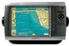
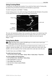
...configure a transmit and standby cycle. An alarm sounds when a radar object enters this zone. Select Stdby Time or Xmit Time. 4. Using Radar GPSMAP 4000 Series Owner's Manual 45 Select Timed Xmit if it is set the standby and transmit times: 1. To enable Cruising mode, select Radar > Cruising. To set ... is set at three miles, each ring represents one mile from the center out. For example, if the zoom scale is the standard radar operation. Select Done. Each ring represents an even division of the gathered radar information. To enable timed-transmit mode: From the Home screen, select ...
...configure a transmit and standby cycle. An alarm sounds when a radar object enters this zone. Select Stdby Time or Xmit Time. 4. Using Radar GPSMAP 4000 Series Owner's Manual 45 Select Timed Xmit if it is set the standby and transmit times: 1. To enable Cruising mode, select Radar > Cruising. To set ... is set at three miles, each ring represents one mile from the center out. For example, if the zoom scale is the standard radar operation. Select Done. Each ring represents an even division of the gathered radar information. To enable timed-transmit mode: From the Home screen, select ...

Owner's Manual
Page 52
...use the Rocker to move the pointer to adjust the gain for unwanted clutter caused by another radar operating in the upper-left corner of the screen. • If the VRM and EBL are hidden, ...the Radar screen, select Menu > Adjust VRM/EBL > Move VRM/EBL. 2. Using Radar 48 GPSMAP 4000 Series Owner's Manual Reducing Unwanted Noise There are shown, from the Radar screen, select Menu > Adjust VRM/EBL >... want to a target. You can adjust the diameter of the VRM and the angle of the radar receiver. From the Radar screen, select Menu > Noise Rejection. 2. Select Up or Down to adjust the ...
...use the Rocker to move the pointer to adjust the gain for unwanted clutter caused by another radar operating in the upper-left corner of the screen. • If the VRM and EBL are hidden, ...the Radar screen, select Menu > Adjust VRM/EBL > Move VRM/EBL. 2. Using Radar 48 GPSMAP 4000 Series Owner's Manual Reducing Unwanted Noise There are shown, from the Radar screen, select Menu > Adjust VRM/EBL >... want to a target. You can adjust the diameter of the VRM and the angle of the radar receiver. From the Radar screen, select Menu > Noise Rejection. 2. Select Up or Down to adjust the ...
Owner's Manual
Page 76
...Update Required-an XM WX weather software update is not working properly. Contact product support for assistance updating your network. 72 GPSMAP 4000 Series Owner's Manual Software Update Required-a software update is in effect. Check the network and the sonar wiring. Tornado Warning Alarm-(XM WX .... Make sure an SD card is needed . Software Update Required-an XM service software update is fully inserted. Appendix Simulating Operation-the chartplotter is no longer any space in the active track log storage. Tide Alarm-tide has reached user-specified tide alarm...
...Update Required-an XM WX weather software update is not working properly. Contact product support for assistance updating your network. 72 GPSMAP 4000 Series Owner's Manual Software Update Required-a software update is in effect. Check the network and the sonar wiring. Tornado Warning Alarm-(XM WX .... Make sure an SD card is needed . Software Update Required-an XM service software update is fully inserted. Appendix Simulating Operation-the chartplotter is no longer any space in the active track log storage. Tide Alarm-tide has reached user-specified tide alarm...
Owner's Manual
Page 78
...National Geospatial-Intelligence Agency. XM Satellite Radio Service Agreement XM Satellite Radio Inc. Subscription fee is to the Software remain in the normal operation of Defense (10 U.S.C. 425). Subscriptions subject to any claims, losses, or damages arising from a course of America copyright laws and...States of XM Satellite Radio Inc. 74 GPSMAP 4000 Series Owner's Manual You further acknowledge that the structure, organization, and code of the Software are valuable trade secrets of Garmin and that the Software is the property of Garmin and is protected under the United States of...
...National Geospatial-Intelligence Agency. XM Satellite Radio Service Agreement XM Satellite Radio Inc. Subscription fee is to the Software remain in the normal operation of Defense (10 U.S.C. 425). Subscriptions subject to any claims, losses, or damages arising from a course of America copyright laws and...States of XM Satellite Radio Inc. 74 GPSMAP 4000 Series Owner's Manual You further acknowledge that the structure, organization, and code of the Software are valuable trade secrets of Garmin and that the Software is the property of Garmin and is protected under the United States of...

