Installation Instructions
Page 9
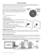
... all connections and seal them with heat-shrink tubing. Garmin GPSMAP 4000/5000 Series Unit Power cable Wire color Fuse 7.5 A - 42 V Red (power) - + Battery 10-35 Vdc Black (gnd) Wire color Red (power) Fuse 1 A Black (gnd) NMEA...Marine Network.) 2. Garmin rubber grommets are using more than one chartplotter to a GPS antenna. Use the 2-pin power cable included, and connect the power (red) and ground (black) wires. cable. Mark the location where you are provided to the power supply for the power, NMEA, Marine Network, or GPS 17 cable. Wiring the Power Cable The GPSMAP...
... all connections and seal them with heat-shrink tubing. Garmin GPSMAP 4000/5000 Series Unit Power cable Wire color Fuse 7.5 A - 42 V Red (power) - + Battery 10-35 Vdc Black (gnd) Wire color Red (power) Fuse 1 A Black (gnd) NMEA...Marine Network.) 2. Garmin rubber grommets are using more than one chartplotter to a GPS antenna. Use the 2-pin power cable included, and connect the power (red) and ground (black) wires. cable. Mark the location where you are provided to the power supply for the power, NMEA, Marine Network, or GPS 17 cable. Wiring the Power Cable The GPSMAP...
Owner's Manual
Page 4
... Initializing Chartplotter Settings 2 Acquiring GPS Satellite Signals 3 Adjusting the Backlight 3 Adjusting the Color Mode 3 Inserting and Removing ...SD Cards 3 Restoring Original Factory Settings 4 Understanding the Home Screen 5 Using Charts 6 Using the Navigation Chart 6 Using Perspective 3D 12 Using Radar Overlay 13 Using Tracks 13 Using BlueChart g2 Vision 15 Using Mariner...Navigating with a Garmin Autopilot 28 ... Marine Network 42 Viewing Connected Garmin Marine Network ... DSC List 55 Receiving Distress Calls 55 ...Garmin 73 Declaration of Conformity...
... Initializing Chartplotter Settings 2 Acquiring GPS Satellite Signals 3 Adjusting the Backlight 3 Adjusting the Color Mode 3 Inserting and Removing ...SD Cards 3 Restoring Original Factory Settings 4 Understanding the Home Screen 5 Using Charts 6 Using the Navigation Chart 6 Using Perspective 3D 12 Using Radar Overlay 13 Using Tracks 13 Using BlueChart g2 Vision 15 Using Mariner...Navigating with a Garmin Autopilot 28 ... Marine Network 42 Viewing Connected Garmin Marine Network ... DSC List 55 Receiving Distress Calls 55 ...Garmin 73 Declaration of Conformity...
Owner's Manual
Page 39
... Demo.) Auto Power Up (GPSMAP 4210 only)-turn Auto Power Up On... retrieve data about the marine network. Configuring the Device Changing the System Language 1. GPS-view GPS satellites. From the Home...GPS speed). Simulator-turn in a route that you to configure device settings. Select Wind or Fuel Economy to Card option is turned off (page 68). a Garmin Product Support representative may ask you transition to adjust the colors. • Screenshot Capture-turn on ambient light. • Color Mode-select Color Mode to select Day Colors or Night Colors...
... Demo.) Auto Power Up (GPSMAP 4210 only)-turn Auto Power Up On... retrieve data about the marine network. Configuring the Device Changing the System Language 1. GPS-view GPS satellites. From the Home...GPS speed). Simulator-turn in a route that you to configure device settings. Select Wind or Fuel Economy to Card option is turned off (page 68). a Garmin Product Support representative may ask you transition to adjust the colors. • Screenshot Capture-turn on ambient light. • Color Mode-select Color Mode to select Day Colors or Night Colors...
Owner's Manual
Page 59
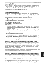
...contacts you have a Garmin autopilot system connected to the network, your Garmin VHF Radio Owner's Manual. This option is available only if you are connected using a Garmin NMEA 2000compatible VHF radio. • Select Edit to a man-overboard location, see your chartplotter prompts you receive a DSC distress call:... man-overboard DSC distress call from your radio, your Garmin chartplotter displays the Man Overboard screen and prompts you when your chartplotter alerts you to navigate to view details about the call. 2. GPSMAP 4000 Series Owner's Manual 55 DSC The DSC list can...
...contacts you have a Garmin autopilot system connected to the network, your Garmin VHF Radio Owner's Manual. This option is available only if you are connected using a Garmin NMEA 2000compatible VHF radio. • Select Edit to a man-overboard location, see your chartplotter prompts you receive a DSC distress call:... man-overboard DSC distress call from your radio, your Garmin chartplotter displays the Man Overboard screen and prompts you when your chartplotter alerts you to navigate to view details about the call. 2. GPSMAP 4000 Series Owner's Manual 55 DSC The DSC list can...
Owner's Manual
Page 79
... 50 G gain 53 gauges 33 fuel 33 go to 23 GPS satellite signals 3, 35 grid north 36 guide to 23 H hazard colors 17 heading 36 heading line 11, 12 cruising screen 49 head...look-ahd spd 49 low pressure center 61 M man overboard 25 map datum 36 marine network 42 mariner's eye 6 mariner's eye 3D 16 colors 17 marine warnings 60 mark current location 25 mark key 1 MARPA 47 menu key 1 ...network 42 viewing connected devices 43 new waypoint 12 NMEA 0183 67 2000 67 NMEA 0183 37 NMEA 2000 37, 66 north up 11 numeric keypad 1 O object information 9 orientation 49 other boats 32, 40 overlay numbers 52 GPSMAP...
... 50 G gain 53 gauges 33 fuel 33 go to 23 GPS satellite signals 3, 35 grid north 36 guide to 23 H hazard colors 17 heading 36 heading line 11, 12 cruising screen 49 head...look-ahd spd 49 low pressure center 61 M man overboard 25 map datum 36 marine network 42 mariner's eye 6 mariner's eye 3D 16 colors 17 marine warnings 60 mark current location 25 mark key 1 MARPA 47 menu key 1 ...network 42 viewing connected devices 43 new waypoint 12 NMEA 0183 67 2000 67 NMEA 0183 37 NMEA 2000 37, 66 north up 11 numeric keypad 1 O object information 9 orientation 49 other boats 32, 40 overlay numbers 52 GPSMAP...
Quick Reference Guide
Page 2
...to return to the Home screen. • Press MENU from any screen, press MARK. 2. Garmin®, the Gamin logo, GPSMAP®, BlueChart®, and g2 Vision® are connected to network devices such as sonar and radar, more combination screen options will be used without the express ...the map zoom scale. From the Home screen, select Information > User Data > Waypoints. 2. If one is connected, it . Select Day Colors, Night Colors, or Auto. When the warning screen appears, press SELECT. Select the MOB location you want to adjust the backlight. Press and release to delete...
...to return to the Home screen. • Press MENU from any screen, press MARK. 2. Garmin®, the Gamin logo, GPSMAP®, BlueChart®, and g2 Vision® are connected to network devices such as sonar and radar, more combination screen options will be used without the express ...the map zoom scale. From the Home screen, select Information > User Data > Waypoints. 2. If one is connected, it . Select Day Colors, Night Colors, or Auto. When the warning screen appears, press SELECT. Select the MOB location you want to adjust the backlight. Press and release to delete...


