Owner's Manual
Page 86
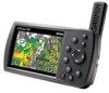
... or Waypoint Edit Page. 2. Highlight the Name field, and press Enter. 3. Use the ROCKER to select the symbol or enter data, and press Enter. 78 GPSMAP 396 Owner's Manual The waypoint is highlighted on the map: 1. Press Enter. Use the ROCKER to enter a new name, and press Enter when finished. From the Waypoint Page...
... or Waypoint Edit Page. 2. Highlight the Name field, and press Enter. 3. Use the ROCKER to select the symbol or enter data, and press Enter. 78 GPSMAP 396 Owner's Manual The waypoint is highlighted on the map: 1. Press Enter. Use the ROCKER to enter a new name, and press Enter when finished. From the Waypoint Page...

Owner's Manual
Page 127
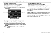
...grids and datums. Location Format Sub Tab Changing the Location Format coordinates the system in which a given location reading is WGS 84. GPSMAP 396 Owner's Manual 119 Altitude-select the unit to describe geographic locations for more information on your altitude. Select Setup from the row of tabs along... the top of a minute (hddd°mm.mmm). Map Datum Sub Tab Datums are used in military settings, in which 17.78 mils equal...
...grids and datums. Location Format Sub Tab Changing the Location Format coordinates the system in which a given location reading is WGS 84. GPSMAP 396 Owner's Manual 119 Altitude-select the unit to describe geographic locations for more information on your altitude. Select Setup from the row of tabs along... the top of a minute (hddd°mm.mmm). Map Datum Sub Tab Datums are used in military settings, in which 17.78 mils equal...

Owner's Manual
Page 190
...153 view details 30 VNAV 41, 42 indicator 41 profile 41 volume 3, 114 VOR 17, 169 GPSMAP 396 Owner's Manual Index route tab 73 RTCM 122, 123 runway criteria 21 S safety and product information v-vi, ...tab 118 Time tab 118 Units tab 119 Welcome tab 120 show details 15 show map 78 signal strength 5 simulated navigation 11-12 182 simulator 11 sonar 134, 135-138 adjusting...90 system alarms 106 System tab 115 T temperature 119, 145 terrain alert 27 Terrain Page aviation mode 36-38 declutter 32 terrain warning 37 text language 115 thermoclines 144 tide chart 110 ...
...153 view details 30 VNAV 41, 42 indicator 41 profile 41 volume 3, 114 VOR 17, 169 GPSMAP 396 Owner's Manual Index route tab 73 RTCM 122, 123 runway criteria 21 S safety and product information v-vi, ...tab 118 Time tab 118 Units tab 119 Welcome tab 120 show details 15 show map 78 signal strength 5 simulated navigation 11-12 182 simulator 11 sonar 134, 135-138 adjusting...90 system alarms 106 System tab 115 T temperature 119, 145 terrain alert 27 Terrain Page aviation mode 36-38 declutter 32 terrain warning 37 text language 115 thermoclines 144 tide chart 110 ...

Owner's Manual
Page 191
... WX Weather 126 additional information 131 finding weather information 132 options 126 radio ID 131 viewing 125 X symbol on terrain 36 Z zoom 29 GPSMAP 396 Owner's Manual 183 Index W WAAS 6, 115, 157, 162, 163 Warning Page 3 waterproof 155 water speed, calibrate 140 water temp 107 waypoint 15,... create 25, 63, 80 deleting 84 edit 77, 78 editing 77, 78 Information Page 59 manage 77 managing 77 mark 25 marking 25, 62, 63, 64, 80 marking underwater 138 name 78 projecting 80 proximity 85 symbol 78 transition 73 weather information finding 132 Weather tab 129 options...
... WX Weather 126 additional information 131 finding weather information 132 options 126 radio ID 131 viewing 125 X symbol on terrain 36 Z zoom 29 GPSMAP 396 Owner's Manual 183 Index W WAAS 6, 115, 157, 162, 163 Warning Page 3 waterproof 155 water speed, calibrate 140 water temp 107 waypoint 15,... create 25, 63, 80 deleting 84 edit 77, 78 editing 77, 78 Information Page 59 manage 77 managing 77 mark 25 marking 25, 62, 63, 64, 80 marking underwater 138 name 78 projecting 80 proximity 85 symbol 78 transition 73 weather information finding 132 Weather tab 129 options...


