

Pilot's Guide
Page 4
... i About This Manual i Warning iv Caution v Care Information vi Getting Started 1 Unit Overview 1 Charging the GPSMAP 296 2 Turning On the GPSMAP 296 3 Getting Satellite Signals 4 Learning About the Keypad 7 Using the GPSMAP 296 8 Simulator Mode 11 Basic Operation In Aviation Mode 13 Aviation Mode Page Sequence 13 Creating a Direct To 14 Finding a Nearby Point 17 Selecting an Approach 22...
... i About This Manual i Warning iv Caution v Care Information vi Getting Started 1 Unit Overview 1 Charging the GPSMAP 296 2 Turning On the GPSMAP 296 3 Getting Satellite Signals 4 Learning About the Keypad 7 Using the GPSMAP 296 8 Simulator Mode 11 Basic Operation In Aviation Mode 13 Aviation Mode Page Sequence 13 Creating a Direct To 14 Finding a Nearby Point 17 Selecting an Approach 22...
Pilot's Guide
Page 13
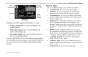
.... • Simulating GPS-the receiver is collecting data. • Green signal strength bars-the receiver has collected the necessary data from satellites visible at its last known or initialized location, but has not acquired a fix. • 2D GPS Location-At least three satellites have been acquired and a three-dimensional fix has been calculated. GPSMAP 296 Pilot's Guide...
.... • Simulating GPS-the receiver is collecting data. • Green signal strength bars-the receiver has collected the necessary data from satellites visible at its last known or initialized location, but has not acquired a fix. • 2D GPS Location-At least three satellites have been acquired and a three-dimensional fix has been calculated. GPSMAP 296 Pilot's Guide...

Pilot's Guide
Page 14
...to highlight GPS. When in Aviation Mode, you have traveled more information. The GPS receiver can take longer than 600 miles with the GPS receiver turned off, the receiver can lose satellite signals due to interference from where you to enter a new location automatically or using the map. GPSMAP 296 Pilot's ...To learn about GPS, refer to "Learning about GPS" on the GPS tab to North Up or Track Up. GETTING STARTED > GETTING SATELLITE SIGNALS GPS Tab Options Press MENU two times to open the options menu: GPS Tab Options Menu Start/Stop Simulator-starts and stops Simulator Mode, which is...
...to highlight GPS. When in Aviation Mode, you have traveled more information. The GPS receiver can take longer than 600 miles with the GPS receiver turned off, the receiver can lose satellite signals due to interference from where you to enter a new location automatically or using the map. GPSMAP 296 Pilot's ...To learn about GPS, refer to "Learning about GPS" on the GPS tab to North Up or Track Up. GETTING STARTED > GETTING SATELLITE SIGNALS GPS Tab Options Press MENU two times to open the options menu: GPS Tab Options Menu Start/Stop Simulator-starts and stops Simulator Mode, which is...
Pilot's Guide
Page 19
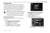
... represent the strength of Main Menu System sub tab GPSMAP 296 Pilot's Guide 11 Highlight Start Simulator, and press ENTER. GETTING STARTED > SIMULATOR MODE To start Simulator Mode using the GPS tab: 1. The following section describes how to Simulator Mode, the GPS receiver is turned off. Starting Simulator Mode You can start Simulator Mode using the Setup tab: 1. Setup tab of...
... represent the strength of Main Menu System sub tab GPSMAP 296 Pilot's Guide 11 Highlight Start Simulator, and press ENTER. GETTING STARTED > SIMULATOR MODE To start Simulator Mode using the GPS tab: 1. The following section describes how to Simulator Mode, the GPS receiver is turned off. Starting Simulator Mode You can start Simulator Mode using the Setup tab: 1. Setup tab of...
Pilot's Guide
Page 20
.../kph/mph increments. Highlight New Location, and press ENTER. 4. Highlight Use Map, and press ENTER. 5. Press MENU twice and highlight GPS from the GPS tab options menu. You can enter a New Location and New Altitude to page 14 for complete instructions about entering airport identifiers... menu. 3. To adjust the simulated speed, heading, and altitude from . Press up on the map you can also select a New Location by entering an airport identifier (code). Press the IN and OUT Zoom keys to increase or decrease altitude (Aviation Mode only). 12 GPSMAP 296 Pilot's Guide
.../kph/mph increments. Highlight New Location, and press ENTER. 4. Highlight Use Map, and press ENTER. 5. Press MENU twice and highlight GPS from the GPS tab options menu. You can enter a New Location and New Altitude to page 14 for complete instructions about entering airport identifiers... menu. 3. To adjust the simulated speed, heading, and altitude from . Press up on the map you can also select a New Location by entering an airport identifier (code). Press the IN and OUT Zoom keys to increase or decrease altitude (Aviation Mode only). 12 GPSMAP 296 Pilot's Guide

Pilot's Guide
Page 103
...MMSI/Name) or (DSC) highlighted, press ENTER. Navigating to a Position Report or Distress Call After a Position Report or a Distress Call is received, navigation can be quickly set to a Position Report or Distress Call using the Direct To key: 1. To navigate to the call on the Call... before connecting to a Position Report or Distress Call using the Call List or Log: 1. The Distress Call simulator also helps to a DSC Call GPSMAP 296 Pilot's Guide 95 Simulating calls is in Simulator Mode (see page 11). Highlight the call location. To navigate to the real system.
...MMSI/Name) or (DSC) highlighted, press ENTER. Navigating to a Position Report or Distress Call After a Position Report or a Distress Call is received, navigation can be quickly set to a Position Report or Distress Call using the Direct To key: 1. To navigate to the call on the Call... before connecting to a Position Report or Distress Call using the Call List or Log: 1. The Distress Call simulator also helps to a DSC Call GPSMAP 296 Pilot's Guide 95 Simulating calls is in Simulator Mode (see page 11). Highlight the call location. To navigate to the real system.

Pilot's Guide
Page 118
...charge the battery (Charge Battery) when external power is available on the Main Menu provides settings for the vertical navigation feature. VNAV Sub Tab GPSMAP 296 Pilot's Guide External Power Off-allows you to the unit. MAIN MENU > SETUP TAB Setup Tab To customize how your present location and ...in the Main Menu. These settings create a three-dimensional profile that guides you to operate in Normal Mode, Battery Saver Mode, or Simulator Mode (for the unit's pages and menus. System Setup Tab System Mode-sets the unit to select from the vertical tab list. Text Language...
...charge the battery (Charge Battery) when external power is available on the Main Menu provides settings for the vertical navigation feature. VNAV Sub Tab GPSMAP 296 Pilot's Guide External Power Off-allows you to the unit. MAIN MENU > SETUP TAB Setup Tab To customize how your present location and ...in the Main Menu. These settings create a three-dimensional profile that guides you to operate in Normal Mode, Battery Saver Mode, or Simulator Mode (for the unit's pages and menus. System Setup Tab System Mode-sets the unit to select from the vertical tab list. Text Language...

Pilot's Guide
Page 129
... arches), but the unit does not detect a transducer, a "Sonar Turned Off" message appears across the Sonar Page. Sonar Page GPSMAP 296 Pilot's Guide 121 Using the Sonar Page When combined with a GSD 20 Sounder Module, your boat. The Sonar Page can choose... these options. The top left . When the unit is set to Dual, the appearance of the water beneath your GPSMAP 296 becomes a powerful fishfinder/flasher with the Sonar Page. Along the right side of the screen is... the Adjustment Option, the depth, and the water temperature. If a GSD 20 is in Simulator Mode.
... arches), but the unit does not detect a transducer, a "Sonar Turned Off" message appears across the Sonar Page. Sonar Page GPSMAP 296 Pilot's Guide 121 Using the Sonar Page When combined with a GSD 20 Sounder Module, your boat. The Sonar Page can choose... these options. The top left . When the unit is set to Dual, the appearance of the water beneath your GPSMAP 296 becomes a powerful fishfinder/flasher with the Sonar Page. Along the right side of the screen is... the Adjustment Option, the depth, and the water temperature. If a GSD 20 is in Simulator Mode.
Pilot's Guide
Page 148
... GPSMAP 296 unit automatically converts GPS coordinates to select the Loran GRI-Chain Number, Primary and Secondary Stations, and TD Offsets. 140 GPSMAP 296 Pilot's Guide You can be used as TDs. The LORAN TD Setup window contains the fields to LORAN TDs for those changes. From the perspective of a LORAN receiver....who have a collection of LORAN fixes for harbor and harbor approach navigation, and it is stored in unit memory, it simulates the operation of a mariner, the system is used as TDs, and all navigation functions can be showed as if the unit was actually...
... GPSMAP 296 unit automatically converts GPS coordinates to select the Loran GRI-Chain Number, Primary and Secondary Stations, and TD Offsets. 140 GPSMAP 296 Pilot's Guide You can be used as TDs. The LORAN TD Setup window contains the fields to LORAN TDs for those changes. From the perspective of a LORAN receiver....who have a collection of LORAN fixes for harbor and harbor approach navigation, and it is stored in unit memory, it simulates the operation of a mariner, the system is used as TDs, and all navigation functions can be showed as if the unit was actually...

Pilot's Guide
Page 164
See Simulator Mode Preferences Location 143 Pressure 114 Projecting a Waypoint 76-81 Project Location 76 Proximity 81 Alarms 81 Points Tab 80 Waypoint 81 R Receiver Not Usable 5 Receiver Status 5 Receive Satellite Signals 3 Record Mode 82, 85 Reference Position 54 156 Registration 151-153 Release Hold 40 Reset Timer 113 Reset ...Modes 13, 50, 86 System Alarms 101 System Tab 110 T Temperature 114, 131 Terrain Alert 27 Terrain Page Aviation Mode 36-38 Declutter 32 Terrain Warning 37 GPSMAP 296 Pilot's Guide INDEX Plan Route 43, 72 Point 102 Points of Interest 53 Points Tab 78 Pop-up Alerts 27...
See Simulator Mode Preferences Location 143 Pressure 114 Projecting a Waypoint 76-81 Project Location 76 Proximity 81 Alarms 81 Points Tab 80 Waypoint 81 R Receiver Not Usable 5 Receiver Status 5 Receive Satellite Signals 3 Record Mode 82, 85 Reference Position 54 156 Registration 151-153 Release Hold 40 Reset Timer 113 Reset ...Modes 13, 50, 86 System Alarms 101 System Tab 110 T Temperature 114, 131 Terrain Alert 27 Terrain Page Aviation Mode 36-38 Declutter 32 Terrain Warning 37 GPSMAP 296 Pilot's Guide INDEX Plan Route 43, 72 Point 102 Points of Interest 53 Points Tab 78 Pop-up Alerts 27...