
Pilot's Guide
Page 3
...Operation in Marine Mode section provides you with information about navigating with the GPSMAP 296 in Aviation Mode. An Index is provided at the end of Contents. About This Manual To get the most out of your new navigation system, take time ... For complete information about navigating with information about some of Garmin GPS and full-featured mapping. GPSMAP 296 Pilot's Guide i The Introduction contains the Table of the manual for choosing the Garmin GPSMAP® 296, an unsurpassed portable aviation receiver that utilizes the proven performance of the main pages and ...
...Operation in Marine Mode section provides you with information about navigating with the GPSMAP 296 in Aviation Mode. An Index is provided at the end of Contents. About This Manual To get the most out of your new navigation system, take time ... For complete information about navigating with information about some of Garmin GPS and full-featured mapping. GPSMAP 296 Pilot's Guide i The Introduction contains the Table of the manual for choosing the Garmin GPSMAP® 296, an unsurpassed portable aviation receiver that utilizes the proven performance of the main pages and ...

Pilot's Guide
Page 4
... > TABLE OF CONTENTS Table of Contents Introduction i About This Manual i Warning iv Caution v Care Information vi Getting Started 1 Unit Overview 1 Charging the GPSMAP 296 2 Turning On the GPSMAP 296 3 Getting Satellite Signals 4 Learning About the Keypad 7 Using the GPSMAP 296 8 Simulator Mode 11 Basic Operation In Aviation Mode 13 Aviation Mode Page Sequence 13 Creating a Direct To 14 Finding...Editing and Managing Waypoints 73 Managing Your Tracks 82 Basic Operation in Marine Mode 86 Marine Mode Page Sequence 86 Navigating in Marine Mode 87 GPSMAP 296 Pilot's Guide
... > TABLE OF CONTENTS Table of Contents Introduction i About This Manual i Warning iv Caution v Care Information vi Getting Started 1 Unit Overview 1 Charging the GPSMAP 296 2 Turning On the GPSMAP 296 3 Getting Satellite Signals 4 Learning About the Keypad 7 Using the GPSMAP 296 8 Simulator Mode 11 Basic Operation In Aviation Mode 13 Aviation Mode Page Sequence 13 Creating a Direct To 14 Finding...Editing and Managing Waypoints 73 Managing Your Tracks 82 Basic Operation in Marine Mode 86 Marine Mode Page Sequence 86 Navigating in Marine Mode 87 GPSMAP 296 Pilot's Guide
Pilot's Guide
Page 8
... user data by manually recording it or downloading it to a PC (transferring it to wipe and air dry the unit before reuse or charging. vi GPSMAP 296 Pilot's Guide at 800/800.1020 or Garmin Europe at 44/0870.8501241. Cleaning the Unit The GPSMAP 296 is waterproof to the... unit. Clean the unit using this guide, contact Garmin Product Support in Water The GPSMAP 296 is constructed of high quality materials...
... user data by manually recording it or downloading it to a PC (transferring it to wipe and air dry the unit before reuse or charging. vi GPSMAP 296 Pilot's Guide at 800/800.1020 or Garmin Europe at 44/0870.8501241. Cleaning the Unit The GPSMAP 296 is waterproof to the... unit. Clean the unit using this guide, contact Garmin Product Support in Water The GPSMAP 296 is constructed of high quality materials...

Pilot's Guide
Page 14
... in Aviation Mode, you can enter the airport identifier. 6 GPS Tips While the receiver is gathering information, your proper location is shown on the map can show as different from where you to interference from such items as the receiver gathers ...GPS receiver turned off, the receiver can lose satellite signals due to manually enter your altitude. The GPS receiver can take longer than normal to initialize and find your location. Press MENU to open the Main Menu. New Altitude-allows you actually are located. Any time you to North Up or Track Up. GPSMAP 296 Pilot...
... in Aviation Mode, you can enter the airport identifier. 6 GPS Tips While the receiver is gathering information, your proper location is shown on the map can show as different from where you to interference from such items as the receiver gathers ...GPS receiver turned off, the receiver can lose satellite signals due to manually enter your altitude. The GPS receiver can take longer than normal to initialize and find your location. Press MENU to open the Main Menu. New Altitude-allows you actually are located. Any time you to North Up or Track Up. GPSMAP 296 Pilot...

Pilot's Guide
Page 16
...fields. To switch between Aviation, Marine, and Automotive Modes, press and hold PAGE. A Field On-screen buttons 8 GPSMAP 296 Pilot's Guide Scroll Bar-when viewing a list of the list. Understanding Terms The GPSMAP 296 unit's advanced keypad system is ...highlighted in the unit's memory. As you should press and quickly release the key. Select (highlight) a field using the ROCKER to begin data entry, or scroll through this manual...
...fields. To switch between Aviation, Marine, and Automotive Modes, press and hold PAGE. A Field On-screen buttons 8 GPSMAP 296 Pilot's Guide Scroll Bar-when viewing a list of the list. Understanding Terms The GPSMAP 296 unit's advanced keypad system is ...highlighted in the unit's memory. As you should press and quickly release the key. Select (highlight) a field using the ROCKER to begin data entry, or scroll through this manual...
Pilot's Guide
Page 21
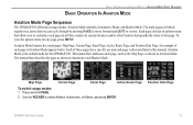
.... 2. Position Data Page GPSMAP 296 Pilot's Guide 13 Each page also has an options menu that allows you to customize each page, such as the Map Page, as shown in this manual. BASIC OPERATION IN AVIATION MODE > AVIATION MODE PAGE SEQUENCE BASIC OPERATION IN AVIATION MODE Aviation Mode Page Sequence The GPSMAP 296 offers three usage modes, Aviation Mode (default), Automotive...
.... 2. Position Data Page GPSMAP 296 Pilot's Guide 13 Each page also has an options menu that allows you to customize each page, such as the Map Page, as shown in this manual. BASIC OPERATION IN AVIATION MODE > AVIATION MODE PAGE SEQUENCE BASIC OPERATION IN AVIATION MODE Aviation Mode Page Sequence The GPSMAP 296 offers three usage modes, Aviation Mode (default), Automotive...

Pilot's Guide
Page 48
... option to manually set your needs. The course deviation needle and course pointer now provide steering guidance to select the scale, and press ENTER. Use the ROCKER to the selected course. With the Panel Page shown, press MENU to re-start the route. 40 GPSMAP 296 Pilot's Guide To... selected. 3. Highlight Release Hold, and press ENTER. Highlight User Selected, and press ENTER. Highlight Set OBS and Hold option, and press ENTER. AVIATION MODE PAGES > PANEL PAGE Setting Up the Panel Page You can set the bug indicator and change the CDI scale: 1. To set a course ...
... option to manually set your needs. The course deviation needle and course pointer now provide steering guidance to select the scale, and press ENTER. Use the ROCKER to the selected course. With the Panel Page shown, press MENU to re-start the route. 40 GPSMAP 296 Pilot's Guide To... selected. 3. Highlight Release Hold, and press ENTER. Highlight User Selected, and press ENTER. Highlight Set OBS and Hold option, and press ENTER. AVIATION MODE PAGES > PANEL PAGE Setting Up the Panel Page You can set the bug indicator and change the CDI scale: 1. To set a course ...

Pilot's Guide
Page 57
... 2 to determine true airspeed. Calculated figure Calculated or user-entered figure E6B Tab Calculated figures AVIATION MODE PAGES > E6B TAB To calculate winds aloft: 1. To restore defaults on the Main Menu. 2. Open the ...manually enter a true airspeed figure in the previous procedure to enter the Calibrated Airspeed, Baro Pressure, and Total Air Temperature. (For Calibrated Airspeed, use the speed shown on a standard outside air including the heating effect caused by speed. Press MENU to highlight the Heading field, and press ENTER. 3. GPSMAP 296 Pilot...
... 2 to determine true airspeed. Calculated figure Calculated or user-entered figure E6B Tab Calculated figures AVIATION MODE PAGES > E6B TAB To calculate winds aloft: 1. To restore defaults on the Main Menu. 2. Open the ...manually enter a true airspeed figure in the previous procedure to enter the Calibrated Airspeed, Baro Pressure, and Total Air Temperature. (For Calibrated Airspeed, use the speed shown on a standard outside air including the heating effect caused by speed. Press MENU to highlight the Heading field, and press ENTER. 3. GPSMAP 296 Pilot...
Pilot's Guide
Page 66
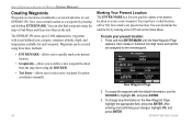
... changes, highlight OK, and press ENTER. 58 GPSMAP 296 Pilot's Guide To accept the waypoint with a user-defined icon, category, comment, altitude, depth, and temperature available for the new waypoint. The GPSMAP 296 stores up to mark your current location as a waypoint by looking at the GPS tab on the New Waypoint Page, highlight.... To change any information on the Main Menu. A default four-digit name and symbol are locations or landmarks you to enter a new waypoint's location coordinates manually. New Waypoint Page 2.
... changes, highlight OK, and press ENTER. 58 GPSMAP 296 Pilot's Guide To accept the waypoint with a user-defined icon, category, comment, altitude, depth, and temperature available for the new waypoint. The GPSMAP 296 stores up to mark your current location as a waypoint by looking at the GPS tab on the New Waypoint Page, highlight.... To change any information on the Main Menu. A default four-digit name and symbol are locations or landmarks you to enter a new waypoint's location coordinates manually. New Waypoint Page 2.

Pilot's Guide
Page 68
... highlight the Location field, and press ENTER. The new waypoint is entered. 60 GPSMAP 296 Pilot's Guide Use ROCKER to enter the new information. 4. Use ROCKER to enter the location ...waypoint. Repeat until the new location is created with the next available waypoint number and the receiver's last known location as the default location. 2. This method can be useful for creating a... waypoint at a specific latitude/longitude location from a chart. You can manually change any of a waypoint, highlight the character you want to create a waypoint (or use ...
... highlight the Location field, and press ENTER. The new waypoint is entered. 60 GPSMAP 296 Pilot's Guide Use ROCKER to enter the new information. 4. Use ROCKER to enter the location ...waypoint. Repeat until the new location is created with the next available waypoint number and the receiver's last known location as the default location. 2. This method can be useful for creating a... waypoint at a specific latitude/longitude location from a chart. You can manually change any of a waypoint, highlight the character you want to create a waypoint (or use ...

Pilot's Guide
Page 71
... 4 until you would like to travel-to your route using the Edit Vias option. Add/Edit Vias Page Showing the original route without Via Points GPSMAP 296 Pilot's Guide 63 Creating a Detour If, while navigating a route, there is open the 2. BASIC OPERATION IN AUTOMOTIVE MODE > EDITING YOUR ROUTE To ... Map or Find, and press ENTER. 5. The new point is added to the route. The GPSMAP 296 recalculates your course based on your route, press Direct To Navigate menu. To end the detour manually, press Direct To again and select Cancel Detour. If you want . Continue steps 2 through which...
... 4 until you would like to travel-to your route using the Edit Vias option. Add/Edit Vias Page Showing the original route without Via Points GPSMAP 296 Pilot's Guide 63 Creating a Detour If, while navigating a route, there is open the 2. BASIC OPERATION IN AUTOMOTIVE MODE > EDITING YOUR ROUTE To ... Map or Find, and press ENTER. 5. The new point is added to the route. The GPSMAP 296 recalculates your course based on your route, press Direct To Navigate menu. To end the detour manually, press Direct To again and select Cancel Detour. If you want . Continue steps 2 through which...

Pilot's Guide
Page 77
... tab Option Menu, highlight Set up the routes to manually transition to the next waypoint. When you select Manual, you are within the entered distance, the GPSMAP 296 leads you to the next waypoint while navigating a route. GPSMAP 296 Pilot's Guide 69 Press MENU twice to open the Active ...Route Page. You can transition to the next point in your route. While you can also set up Routes, and press ENTER to have created in your GPSMAP 296 unit. Highlight Next Route...
... tab Option Menu, highlight Set up the routes to manually transition to the next waypoint. When you select Manual, you are within the entered distance, the GPSMAP 296 leads you to the next waypoint while navigating a route. GPSMAP 296 Pilot's Guide 69 Press MENU twice to open the Active ...Route Page. You can transition to the next point in your route. While you can also set up Routes, and press ENTER to have created in your GPSMAP 296 unit. Highlight Next Route...

Pilot's Guide
Page 80
...route turns white when the arrow is over the route). Press ENTER. 5. To set speed and fuel/plan your vehicle (such as the operator's manual or performance specifications) and make note of the units of tabs. 2. Highlight Plan Route, and press ENTER. (Highlight Set Speed and... are added to open the Route Review Page options menu. 3. GPSMAP 296 Pilot's Guide Use ROCKER to drag the route to the Route Review Page. Select the route, and press ENTER. System setting changes for your route: 1. When in Aviation Mode.) Editing the route on the map: 1. Press QUIT to...
...route turns white when the arrow is over the route). Press ENTER. 5. To set speed and fuel/plan your vehicle (such as the operator's manual or performance specifications) and make note of the units of tabs. 2. Highlight Plan Route, and press ENTER. (Highlight Set Speed and... are added to open the Route Review Page options menu. 3. GPSMAP 296 Pilot's Guide Use ROCKER to drag the route to the Route Review Page. Select the route, and press ENTER. System setting changes for your route: 1. When in Aviation Mode.) Editing the route on the map: 1. Press QUIT to...

Pilot's Guide
Page 126
...unit is receiving a DGPS signal, the SNR (Signal to highlight the Beacon field, and press ENTER. 2. The Distance may or may not show data. With the unit set to GARMIN DGPS or ...not making connection with 30 being broadcast from the DGPS site. To restart the scan: 1. To manually enter a frequency and bit rate: 1. For DGPS transmitter problems or to find the most... the frequencies and bit rates. • Receiving-the unit is receiving DGPS signal and ready for their Web site at http://www.navcen.uscg.mil/. 118 GPSMAP 296 Pilot's Guide Highlight the Frequency or Bit Rate ...
...unit is receiving a DGPS signal, the SNR (Signal to highlight the Beacon field, and press ENTER. 2. The Distance may or may not show data. With the unit set to GARMIN DGPS or ...not making connection with 30 being broadcast from the DGPS site. To restart the scan: 1. To manually enter a frequency and bit rate: 1. For DGPS transmitter problems or to find the most... the frequencies and bit rates. • Receiving-the unit is receiving DGPS signal and ready for their Web site at http://www.navcen.uscg.mil/. 118 GPSMAP 296 Pilot's Guide Highlight the Frequency or Bit Rate ...

Pilot's Guide
Page 134
...sub tab, use either your boat's speedometer reading (not always accurate) or a stopwatch to manually enter a calibration, press ENTER while the speed is automatically shown. Both the top ground ..."Water Speed Sensor Is Not Working" appears at the bottom of speed sensor cables. 126 GPSMAP 296 Pilot's Guide Check connections of the calibration window. SETTING UP AND USING SONAR > SETTING UP...press ENTER. The calibration should take place in water having little or no current. If a GPS ground speed is not moving or safely increase boat speed. Bring the boat to highlight Calibrate ...
...sub tab, use either your boat's speedometer reading (not always accurate) or a stopwatch to manually enter a calibration, press ENTER while the speed is automatically shown. Both the top ground ..."Water Speed Sensor Is Not Working" appears at the bottom of speed sensor cables. 126 GPSMAP 296 Pilot's Guide Check connections of the calibration window. SETTING UP AND USING SONAR > SETTING UP...press ENTER. The calibration should take place in water having little or no current. If a GPS ground speed is not moving or safely increase boat speed. Bring the boat to highlight Calibrate ...
Pilot's Guide
Page 146
... operational in the sequence you want to the Garmin Web site at http://www.garmin.com/aboutGPS/manual.html. For more quickly. navcen.uscg.gov/) for Beginners, which can be found on geographic coordinates (Latitude and Longitude). Differential Field Differential receiver status is receiving WAAS corrections. 138 GPSMAP 296 Pilot's Guide GPS works in any weather conditions, anywhere in...
... operational in the sequence you want to the Garmin Web site at http://www.garmin.com/aboutGPS/manual.html. For more quickly. navcen.uscg.gov/) for Beginners, which can be found on geographic coordinates (Latitude and Longitude). Differential Field Differential receiver status is receiving WAAS corrections. 138 GPSMAP 296 Pilot's Guide GPS works in any weather conditions, anywhere in...
Pilot's Guide
Page 147
... from the reference stations and create a GPS data correction message. All SBAS systems use the same receiver frequency; Eventually, there will be capable of the GPS signal and increase location accuracy for an available frequency. Currently, enabling WAAS on either coast, collect data from an SBAS satellite. GPSMAP 296 Pilot's Guide 139 To enable WAAS, refer...
... from the reference stations and create a GPS data correction message. All SBAS systems use the same receiver frequency; Eventually, there will be capable of the GPS signal and increase location accuracy for an available frequency. Currently, enabling WAAS on either coast, collect data from an SBAS satellite. GPSMAP 296 Pilot's Guide 139 To enable WAAS, refer...
Pilot's Guide
Page 150
... different maps and charts use with Paper Land Maps, available for download at http://www.garmin.com/manuals/UsingaGarminGP SwithPaperLandMaps_Manual.pdf. 142 GPSMAP 296 Pilot's Guide You can be viewed on a map or chart are referenced to use different location formats, Garmin GPS units allow you to choose the correct coordinate system for the advanced user), are...
... different maps and charts use with Paper Land Maps, available for download at http://www.garmin.com/manuals/UsingaGarminGP SwithPaperLandMaps_Manual.pdf. 142 GPSMAP 296 Pilot's Guide You can be viewed on a map or chart are referenced to use different location formats, Garmin GPS units allow you to choose the correct coordinate system for the advanced user), are...
Pilot's Guide
Page 158
...manual. Look for the GPSMAP 296. PLEASE READ THIS AGREEMENT CAREFULLY. Have the serial number of your GPSMAP 296 handy and connect to the Software remain with Garmin. at sales@garmin.com. Software License Agreement BY USING THE GPSMAP 296....garmin.com). Serial Number Contact Garmin If you should encounter any difficulty while using your GPS ...Garmin and that the Software is the property of Garmin and is lost, stolen, or needs service. contact Garmin Product Support by completing our online registration today! or by e-mail at 44/0870.8501241. 150 GPSMAP 296 Pilot...
...manual. Look for the GPSMAP 296. PLEASE READ THIS AGREEMENT CAREFULLY. Have the serial number of your GPSMAP 296 handy and connect to the Software remain with Garmin. at sales@garmin.com. Software License Agreement BY USING THE GPSMAP 296....garmin.com). Serial Number Contact Garmin If you should encounter any difficulty while using your GPS ...Garmin and that the Software is the property of Garmin and is lost, stolen, or needs service. contact Garmin Product Support by completing our online registration today! or by e-mail at 44/0870.8501241. 150 GPSMAP 296 Pilot...


