

Pilot's Guide
Page 4
...Caution v Care Information vi Getting Started 1 Unit Overview 1 Charging the GPSMAP 296 2 Turning On the GPSMAP 296 3 Getting Satellite Signals 4 Learning About the Keypad 7 Using the GPSMAP 296 8 Simulator Mode 11 Basic Operation In Aviation Mode 13 Aviation Mode Page Sequence 13 Creating a Direct To 14 Finding a Nearby ...Highway Page 65 Current Route Page 67 Trip Computer Page 68 Editing and Managing Routes 69 Editing and Managing Waypoints 73 Managing Your Tracks 82 Basic Operation in Marine Mode 86 Marine Mode Page Sequence 86 Navigating in Marine Mode 87 GPSMAP 296...
...Caution v Care Information vi Getting Started 1 Unit Overview 1 Charging the GPSMAP 296 2 Turning On the GPSMAP 296 3 Getting Satellite Signals 4 Learning About the Keypad 7 Using the GPSMAP 296 8 Simulator Mode 11 Basic Operation In Aviation Mode 13 Aviation Mode Page Sequence 13 Creating a Direct To 14 Finding a Nearby ...Highway Page 65 Current Route Page 67 Trip Computer Page 68 Editing and Managing Routes 69 Editing and Managing Waypoints 73 Managing Your Tracks 82 Basic Operation in Marine Mode 86 Marine Mode Page Sequence 86 Navigating in Marine Mode 87 GPSMAP 296...
Pilot's Guide
Page 20
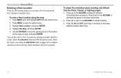
...64257;er (code). Press down on the ROCKER to increase or decrease altitude (Aviation Mode only). 12 GPSMAP 296 Pilot's Guide GETTING STARTED > SIMULATOR MODE Entering a New Location From the GPS options menu you want, and press ENTER. Refer to open the options menu.... 3. To adjust the simulated speed, heading, and altitude from the vertical menu. 2. Press MENU twice and highlight GPS from the Panel, Pointer, or Highway...
...64257;er (code). Press down on the ROCKER to increase or decrease altitude (Aviation Mode only). 12 GPSMAP 296 Pilot's Guide GETTING STARTED > SIMULATOR MODE Entering a New Location From the GPS options menu you want, and press ENTER. Refer to open the options menu.... 3. To adjust the simulated speed, heading, and altitude from the vertical menu. 2. Press MENU twice and highlight GPS from the Panel, Pointer, or Highway...
Pilot's Guide
Page 36
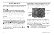
...GPSMAP 296 always turns on in location mode, with the last known location centered on the Map Page. See page 33 for range adjustments. AVIATION MODE PAGES > MAP PAGE AVIATION... some additional aviation features, such...Aviation Mode, by default on the Map Page is an aircraft symbol in Aviation... Map Zoom Range Map Page (Aviation Mode) A navigation arc (Horizontal...GPSMAP 296 enters pan mode, which moves the map to keep your present location in Aviation Mode when the Map Page is shown on the map. See page 33. 28 GPSMAP 296...GPSMAP 296 features a real-time moving map that includes airspace ...
...GPSMAP 296 always turns on in location mode, with the last known location centered on the Map Page. See page 33 for range adjustments. AVIATION MODE PAGES > MAP PAGE AVIATION... some additional aviation features, such...Aviation Mode, by default on the Map Page is an aircraft symbol in Aviation... Map Zoom Range Map Page (Aviation Mode) A navigation arc (Horizontal...GPSMAP 296 enters pan mode, which moves the map to keep your present location in Aviation Mode when the Map Page is shown on the map. See page 33. 28 GPSMAP 296...GPSMAP 296 features a real-time moving map that includes airspace ...

Pilot's Guide
Page 40
... and navaids that you want to measure to measure from the map. Measuring Distance You can also declutter the map on the map. Aviation Mode has various levels of measurement, labeled "ENT REF" Measure Distance 4. You can measure the distance and bearing between two map items..., and press ENTER. Press ENTER again. Move the arrow to finish. 32 GPSMAP 296 Pilot's Guide Press QUIT to the reference point (the starting point on the Terrain Page. The background map detail-including highways, cities, rivers & smaller lakes-is removed from ), and press ENTER. A push-...
... and navaids that you want to measure to measure from the map. Measuring Distance You can also declutter the map on the map. Aviation Mode has various levels of measurement, labeled "ENT REF" Measure Distance 4. You can measure the distance and bearing between two map items..., and press ENTER. Press ENTER again. Move the arrow to finish. 32 GPSMAP 296 Pilot's Guide Press QUIT to the reference point (the starting point on the Terrain Page. The background map detail-including highways, cities, rivers & smaller lakes-is removed from ), and press ENTER. A push-...

Pilot's Guide
Page 42
... page you want to open the options menu. 3. Press up . 34 Changing a Data Field GPSMAP 296 Pilot's Guide Select the option you are setting up or down on the ROCKER to highlight the ... press ENTER. You can adjust the data fields on the screen: Map, Terrain, Panel, Compass, Highway, Location Data, Trip Computer, and optional Sonar Page. Highlight Set up the page layout: 1. To return ...press ENTER. You can adjust how the following pages look on many of the Map Page 4. AVIATION MODE PAGES > MAP PAGE Changing the Page Layout and Data Fields To customize the pages to show...
... page you want to open the options menu. 3. Press up . 34 Changing a Data Field GPSMAP 296 Pilot's Guide Select the option you are setting up or down on the ROCKER to highlight the ... press ENTER. You can adjust the data fields on the screen: Map, Terrain, Panel, Compass, Highway, Location Data, Trip Computer, and optional Sonar Page. Highlight Set up the page layout: 1. To return ...press ENTER. You can adjust how the following pages look on many of the Map Page 4. AVIATION MODE PAGES > MAP PAGE Changing the Page Layout and Data Fields To customize the pages to show...

Pilot's Guide
Page 58
...highlight the Display tab. 2. Select On, and press ENTER. 50 GPSMAP 296 Pilot's Guide BASIC OPERATION IN AUTOMOTIVE MODE > AUTOMOTIVE MODE PAGE SEQUENCE BASIC OPERATION IN AUTOMOTIVE MODE To switch usage modes: 1. Highlight the Highway Page or Compass Page Page fields, and press ENTER. Map... Page Compass Page (Optional) Highway Page (Optional) Current Route Page Trip Computer Page To add the Compass or Highway Pages: 1. Press and hold PAGE. 2. Use the ROCKER to select Aviation, Automotive, or ...
...highlight the Display tab. 2. Select On, and press ENTER. 50 GPSMAP 296 Pilot's Guide BASIC OPERATION IN AUTOMOTIVE MODE > AUTOMOTIVE MODE PAGE SEQUENCE BASIC OPERATION IN AUTOMOTIVE MODE To switch usage modes: 1. Highlight the Highway Page or Compass Page Page fields, and press ENTER. Map... Page Compass Page (Optional) Highway Page (Optional) Current Route Page Trip Computer Page To add the Compass or Highway Pages: 1. Press and hold PAGE. 2. Use the ROCKER to select Aviation, Automotive, or ...

Pilot's Guide
Page 73
... on course. Highlight the Highway Page field, and press ENTER. 4. As you head toward the violet bar (or arrows) until it lines up with a white line down the center of the highway. GPSMAP 296 Pilot's Guide AUTOMOTIVE MODE PAGES AND FEATURES > HIGHWAY PAGE To hide/show a... larger or smaller view of the highway represents your track line. In Automotive Mode, the Highway Page is your track line. Nearby waypoints not in...
... on course. Highlight the Highway Page field, and press ENTER. 4. As you head toward the violet bar (or arrows) until it lines up with a white line down the center of the highway. GPSMAP 296 Pilot's Guide AUTOMOTIVE MODE PAGES AND FEATURES > HIGHWAY PAGE To hide/show a... larger or smaller view of the highway represents your track line. In Automotive Mode, the Highway Page is your track line. Nearby waypoints not in...

Pilot's Guide
Page 74
... Data Fields-allows you to specify the type of data shown in each data field used on the screen. Highway Page Options Menu 66 Set up Highway GPSMAP 296 Pilot's Guide The data fields, located along the right side of the page, provide a userselectable layout of ...various types of useful data. Press ENTER. AUTOMOTIVE MODE PAGES AND FEATURES > HIGHWAY PAGE Highway Page Options The Highway Page options menu allows you...
... Data Fields-allows you to specify the type of data shown in each data field used on the screen. Highway Page Options Menu 66 Set up Highway GPSMAP 296 Pilot's Guide The data fields, located along the right side of the page, provide a userselectable layout of ...various types of useful data. Press ENTER. AUTOMOTIVE MODE PAGES AND FEATURES > HIGHWAY PAGE Highway Page Options The Highway Page options menu allows you...

Pilot's Guide
Page 94
... Aviation, Automotive, or Marine, and press ENTER. Press and hold the PAGE key. 2. Map Page Compass Page Highway Page Active Route Page Position Data Page Sonar Page (Optional) 86 GPSMAP 296 Pilot's Guide Marine Mode Page Sequence Marine Mode features five main pages: the Map, Compass, Highway..., Active Route, and Position Data Page. Use the ROCKER to a sonar module, such as a Garmin GSD 20, an additional Sonar Page is...
... Aviation, Automotive, or Marine, and press ENTER. Press and hold the PAGE key. 2. Map Page Compass Page Highway Page Active Route Page Position Data Page Sonar Page (Optional) 86 GPSMAP 296 Pilot's Guide Marine Mode Page Sequence Marine Mode features five main pages: the Map, Compass, Highway..., Active Route, and Position Data Page. Use the ROCKER to a sonar module, such as a Garmin GSD 20, an additional Sonar Page is...

Pilot's Guide
Page 95
... To Point, Navigate Route, and Navigate Track options operate the same as in the waypoint list and can be deleted like any other waypoint. 87 GPSMAP 296 Pilot's Guide Man OverBoard confirmation screen 2. BASIC OPERATION IN MARINE MODE > NAVIGATING IN MARINE MODE Man OverBoard (MOB) The Man OverBoard ...Marine Mode Accessed by pressing Direct To When you back to that location. In Marine Mode, you can use the Map Page, Compass Page, Highway Page, and Position Data Page to help navigate to your current location to the destination on those options. In Marine Mode, press and hold ...
... To Point, Navigate Route, and Navigate Track options operate the same as in the waypoint list and can be deleted like any other waypoint. 87 GPSMAP 296 Pilot's Guide Man OverBoard confirmation screen 2. BASIC OPERATION IN MARINE MODE > NAVIGATING IN MARINE MODE Man OverBoard (MOB) The Man OverBoard ...Marine Mode Accessed by pressing Direct To When you back to that location. In Marine Mode, you can use the Map Page, Compass Page, Highway Page, and Position Data Page to help navigate to your current location to the destination on those options. In Marine Mode, press and hold ...

Pilot's Guide
Page 116
... when it in the main page sequence. Highway Page-enables the page and places it is used. MAIN MENU > DISPLAY TAB Display Tab The Display tab on the Main Menu allows you to set several features of tabs. Highlight Restore Defaults, and press ENTER. 108 GPSMAP 296 Pilot's Guide Highlight Display from the...
... when it in the main page sequence. Highway Page-enables the page and places it is used. MAIN MENU > DISPLAY TAB Display Tab The Display tab on the Main Menu allows you to set several features of tabs. Highlight Restore Defaults, and press ENTER. 108 GPSMAP 296 Pilot's Guide Highlight Display from the...

Pilot's Guide
Page 120
... Turn Pop-up-turns the Next Turn window Off, or opens the window when you hold Direct To , opens automatically (Automatically Only), or Both. 112 GPSMAP 296 Pilot's Guide This is available. Select Setup from the row of tabs along the top of your route (Prompted), or whether the unit recalculates automatically... your way or if no other road is especially nice if you want to open the Guidance sub tab, press MENU twice to avoid major highways, for example. The unit uses these road types only if alternative routes take you too far out of the page. Guidance Sub Tab To open...
... Turn Pop-up-turns the Next Turn window Off, or opens the window when you hold Direct To , opens automatically (Automatically Only), or Both. 112 GPSMAP 296 Pilot's Guide This is available. Select Setup from the row of tabs along the top of your route (Prompted), or whether the unit recalculates automatically... your way or if no other road is especially nice if you want to open the Guidance sub tab, press MENU twice to avoid major highways, for example. The unit uses these road types only if alternative routes take you too far out of the page. Guidance Sub Tab To open...
Pilot's Guide
Page 162
...Current Location 3 Finding an Item in Automotive or Marine Mode 53-55 Finding a Nearby Aviation Point 17-21 Fishing Information 106 Fish Symbols 125 Flasher 127 FlightBook 45, 146 Flight... your Flight Plan 27 Follow Roads 57 FSS 17 Fuel Flow 43, 46, 72 G GARMIN DGPS 116, 117 Getting Satellite Signals 4-6 Going to a Destination 51 Go To 14, ...GPS 139-140 Learning About 139 Off/On 5 Page 6, 69 GRI Chain 142 GSD 20 120 Guidance Tab 112 H Heading 115 Highways Avoid 112 Highway Page 108 Automotive Mode 65-66 Data Fields 66 Page Layout 66 Setup 66 HSI 39 Bug Indicator 33 Hunt & Fish Tab 106 GPSMAP 296...
...Current Location 3 Finding an Item in Automotive or Marine Mode 53-55 Finding a Nearby Aviation Point 17-21 Fishing Information 106 Fish Symbols 125 Flasher 127 FlightBook 45, 146 Flight... your Flight Plan 27 Follow Roads 57 FSS 17 Fuel Flow 43, 46, 72 G GARMIN DGPS 116, 117 Getting Satellite Signals 4-6 Going to a Destination 51 Go To 14, ...GPS 139-140 Learning About 139 Off/On 5 Page 6, 69 GRI Chain 142 GSD 20 120 Guidance Tab 112 H Heading 115 Highways Avoid 112 Highway Page 108 Automotive Mode 65-66 Data Fields 66 Page Layout 66 Setup 66 HSI 39 Bug Indicator 33 Hunt & Fish Tab 106 GPSMAP 296...
