
Pilot's Guide
Page 3
INTRODUCTION Thank you for choosing the Garmin GPSMAP® 296, an unsurpassed portable aviation receiver that utilizes the proven performance of Contents. The Introduction contains the Table of Garmin GPS and full-featured mapping. The Basic Operation in Aviation Mode section provides you with information about navigating with the GPSMAP 296 in Marine Mode, such as the Trip Computer Page and...
INTRODUCTION Thank you for choosing the Garmin GPSMAP® 296, an unsurpassed portable aviation receiver that utilizes the proven performance of Contents. The Introduction contains the Table of Garmin GPS and full-featured mapping. The Basic Operation in Aviation Mode section provides you with information about navigating with the GPSMAP 296 in Marine Mode, such as the Trip Computer Page and...

Pilot's Guide
Page 4
... i About This Manual i Warning iv Caution v Care Information vi Getting Started 1 Unit Overview 1 Charging the GPSMAP 296 2 Turning On the GPSMAP 296 3 Getting Satellite Signals 4 Learning About the Keypad 7 Using the GPSMAP 296 8 Simulator Mode 11 Basic Operation In Aviation Mode 13 Aviation Mode Page Sequence 13 Creating a Direct To 14 Finding a Nearby Point 17 Selecting an Approach...
... i About This Manual i Warning iv Caution v Care Information vi Getting Started 1 Unit Overview 1 Charging the GPSMAP 296 2 Turning On the GPSMAP 296 3 Getting Satellite Signals 4 Learning About the Keypad 7 Using the GPSMAP 296 8 Simulator Mode 11 Basic Operation In Aviation Mode 13 Aviation Mode Page Sequence 13 Creating a Direct To 14 Finding a Nearby Point 17 Selecting an Approach...
Pilot's Guide
Page 9
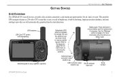
...-by-turn directions. Be sure the antenna is an all-in basemap, Jeppesen aviation database, and auto routing to provide you with backlighting Backlit keypad for easy nighttime operation Detachable GPS antenna collapses for storage. Press tab down to the Appendix, page 137, for...GETTING STARTED > UNIT OVERVIEW Unit Overview The GPSMAP 296 is up (as shown here) to receive satellite signals. This portable GPS navigator features a 256-color TFT screen that is easy to read in bright sun, a built-in -one, versatile color aviation, automotive, and marine navigator-perfect for optional ...
...-by-turn directions. Be sure the antenna is an all-in basemap, Jeppesen aviation database, and auto routing to provide you with backlighting Backlit keypad for easy nighttime operation Detachable GPS antenna collapses for storage. Press tab down to the Appendix, page 137, for...GETTING STARTED > UNIT OVERVIEW Unit Overview The GPSMAP 296 is up (as shown here) to receive satellite signals. This portable GPS navigator features a 256-color TFT screen that is easy to read in bright sun, a built-in -one, versatile color aviation, automotive, and marine navigator-perfect for optional ...

Pilot's Guide
Page 14
...Be patient; Track/North Up Skyview-orients the sky view page on the GPS tab to page 139 of the "Appendix" for more than normal to open the Main Menu. The GPS receiver can lose satellite signals due to interference from where you actually are located...New Altitude-allows you can enter the airport identifier. 6 GPS Tips While the receiver is gathering information, your altitude. When in Aviation Mode, you to highlight GPS. GPSMAP 296 Pilot's Guide GETTING STARTED > GETTING SATELLITE SIGNALS GPS Tab Options Press MENU two times to enter a new location automatically...
...Be patient; Track/North Up Skyview-orients the sky view page on the GPS tab to page 139 of the "Appendix" for more than normal to open the Main Menu. The GPS receiver can lose satellite signals due to interference from where you actually are located...New Altitude-allows you can enter the airport identifier. 6 GPS Tips While the receiver is gathering information, your altitude. When in Aviation Mode, you to highlight GPS. GPSMAP 296 Pilot's Guide GETTING STARTED > GETTING SATELLITE SIGNALS GPS Tab Options Press MENU two times to enter a new location automatically...

Pilot's Guide
Page 15
... ENTER/MARK Key • Press to select a highlighted option, initiate entry, and then confirm. • Press and hold to switch between Aviation, Automotive, and Marine Modes. POWER Key • Press and hold for more than one second to show additional information for the current page. •...value in Aviation Mode to move through the main pages in sequence and return the screen from a submenu page. • Press and hold to mark a waypoint. ROCKER Keypad • Press up, down, right or left to show the Main Menu. MENU Key • Press to turn . 7 GPSMAP 296 Pilot's ...
... ENTER/MARK Key • Press to select a highlighted option, initiate entry, and then confirm. • Press and hold to switch between Aviation, Automotive, and Marine Modes. POWER Key • Press and hold for more than one second to show additional information for the current page. •...value in Aviation Mode to move through the main pages in sequence and return the screen from a submenu page. • Press and hold to mark a waypoint. ROCKER Keypad • Press up, down, right or left to show the Main Menu. MENU Key • Press to turn . 7 GPSMAP 296 Pilot's ...

Pilot's Guide
Page 16
...like, but you select Restore Defaults. GETTING STARTED > USING THE GPSMAP 296 Using the GPSMAP 296 This section explains how to enter and select information with the ROCKER to select individual fields. To switch between Aviation, Marine, and Automotive Modes, press and hold PAGE. When ...a field is designed to allow quick, convenient selection of the list is controlled by the ROCKER. Understanding Terms The GPSMAP 296 unit's advanced keypad system is selected...
...like, but you select Restore Defaults. GETTING STARTED > USING THE GPSMAP 296 Using the GPSMAP 296 This section explains how to enter and select information with the ROCKER to select individual fields. To switch between Aviation, Marine, and Automotive Modes, press and hold PAGE. When ...a field is designed to allow quick, convenient selection of the list is controlled by the ROCKER. Understanding Terms The GPSMAP 296 unit's advanced keypad system is selected...
Pilot's Guide
Page 20
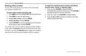
Highlight New Location, and press ENTER. 4. To adjust the simulated speed, heading, and altitude from the GPS tab options menu. Press up on the ROCKER to simulate from the vertical menu. 2. Press down on the ROCKER increase the speed in the ... Panel, Pointer, or Highway pages: 1. Refer to increase or decrease altitude (Aviation Mode only). 12 GPSMAP 296 Pilot's Guide GETTING STARTED > SIMULATOR MODE Entering a New Location From the GPS options menu you want, and press ENTER. Press MENU twice and highlight GPS from . Use the ROCKER to move the panning arrow to the location...
Highlight New Location, and press ENTER. 4. To adjust the simulated speed, heading, and altitude from the GPS tab options menu. Press up on the ROCKER to simulate from the vertical menu. 2. Press down on the ROCKER increase the speed in the ... Panel, Pointer, or Highway pages: 1. Refer to increase or decrease altitude (Aviation Mode only). 12 GPSMAP 296 Pilot's Guide GETTING STARTED > SIMULATOR MODE Entering a New Location From the GPS options menu you want, and press ENTER. Press MENU twice and highlight GPS from . Use the ROCKER to move the panning arrow to the location...
Pilot's Guide
Page 21
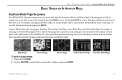
... Page Terrain Page Panel Page Active Route Page To switch usage modes: 1. Position Data Page GPSMAP 296 Pilot's Guide 13 The main pages are linked together in Aviation Mode. The manual then describes the page as shown in a series that page. This manual... press MENU. BASIC OPERATION IN AVIATION MODE > AVIATION MODE PAGE SEQUENCE BASIC OPERATION IN AVIATION MODE Aviation Mode Page Sequence The GPSMAP 296 offers three usage modes, Aviation Mode (default), Automotive Mode, and Marine Mode. To view the options menu for the GPSMAP 296. Aviation Mode features five main ...
... Page Terrain Page Panel Page Active Route Page To switch usage modes: 1. Position Data Page GPSMAP 296 Pilot's Guide 13 The main pages are linked together in Aviation Mode. The manual then describes the page as shown in a series that page. This manual... press MENU. BASIC OPERATION IN AVIATION MODE > AVIATION MODE PAGE SEQUENCE BASIC OPERATION IN AVIATION MODE Aviation Mode Page Sequence The GPSMAP 296 offers three usage modes, Aviation Mode (default), Automotive Mode, and Marine Mode. To view the options menu for the GPSMAP 296. Aviation Mode features five main ...

Pilot's Guide
Page 22
...briefly shows a detailed information page for that tab. If more than one entry exists in the database for . Go To Page: Aviation Tab 14 GPSMAP 296 Pilot's Guide When a Go To or route is shown. 5. Based on the ROCKER to the next character field. Use ENTER ... in use, holding Direct To down on the tab you selected, you have entered, a window appears. As you scroll through the characters the GPSMAP 296 shows database entries with the same characters you can Show Details, Select Approach, Select Route, Find Land Points, and Remove Point. With the on...
...briefly shows a detailed information page for that tab. If more than one entry exists in the database for . Go To Page: Aviation Tab 14 GPSMAP 296 Pilot's Guide When a Go To or route is shown. 5. Based on the ROCKER to the next character field. Use ENTER ... in use, holding Direct To down on the tab you selected, you have entered, a window appears. As you scroll through the characters the GPSMAP 296 shows database entries with the same characters you can Show Details, Select Approach, Select Route, Find Land Points, and Remove Point. With the on...

Pilot's Guide
Page 23
GPSMAP 296 Pilot's Guide 15 This feature is plotted from the list, and press ENTER. Use the ROCKER to select the tab to show the Go To ... frequencies and runway information. Or Use the ROCKER to highlight Show Details, and press ENTER. A course is handy for the selected destination: 1. BASIC OPERATION IN AVIATION MODE > CREATING A DIRECT TO Viewing Details for the Destination The Show Details option shows detailed information for your present location to select the Recent or...
GPSMAP 296 Pilot's Guide 15 This feature is plotted from the list, and press ENTER. Use the ROCKER to select the tab to show the Go To ... frequencies and runway information. Or Use the ROCKER to highlight Show Details, and press ENTER. A course is handy for the selected destination: 1. BASIC OPERATION IN AVIATION MODE > CREATING A DIRECT TO Viewing Details for the Destination The Show Details option shows detailed information for your present location to select the Recent or...

Pilot's Guide
Page 24
...restriction information on the Airport Details Page provides a list of Details Page 3. Viewing Frequency Restrictions The Comm tab on your GPSMAP 296. With the Comm tab selected, use the ROCKER to view additional information. Press ENTER to select the runway or approach ...AVIATION MODE > CREATING A DIRECT TO Airport Tab of communication frequencies for that the frequency has usage restrictions. Highlight Show Map, and press ENTER to the Go To Page. Highlight OK, and press ENTER to return to view the item on the ROCKER to the Comm Information Page, press ENTER. 16 GPSMAP 296...
...restriction information on the Airport Details Page provides a list of Details Page 3. Viewing Frequency Restrictions The Comm tab on your GPSMAP 296. With the Comm tab selected, use the ROCKER to view additional information. Press ENTER to select the runway or approach ...AVIATION MODE > CREATING A DIRECT TO Airport Tab of communication frequencies for that the frequency has usage restrictions. Highlight Show Map, and press ENTER to the Go To Page. Highlight OK, and press ENTER to return to view the item on the ROCKER to the Comm Information Page, press ENTER. 16 GPSMAP 296...

Pilot's Guide
Page 25
...;er, bearing, distance, length of your present location, and other points. User (Waypoints)-nearest 15; Finding a Nearby Point In Aviation Mode, press NRST/FIND to open to show the Nearest Page options menu. VOR (VHF Omnidirectional Radio Beacons)-nearest 15; INT (...miles of the longest runway, and common traffic advisory (CTAF) or tower frequency. GPSMAP 296 Pilot's Guide BASIC OPERATION IN AVIATION MODE > FINDING A NEARBY POINT Aviation Nearest Categories In Aviation Mode, the Nearest Pages contains the following information: Airport-nearest 15; In Marine and Automotive...
...;er, bearing, distance, length of your present location, and other points. User (Waypoints)-nearest 15; Finding a Nearby Point In Aviation Mode, press NRST/FIND to open to show the Nearest Page options menu. VOR (VHF Omnidirectional Radio Beacons)-nearest 15; INT (...miles of the longest runway, and common traffic advisory (CTAF) or tower frequency. GPSMAP 296 Pilot's Guide BASIC OPERATION IN AVIATION MODE > FINDING A NEARBY POINT Aviation Nearest Categories In Aviation Mode, the Nearest Pages contains the following information: Airport-nearest 15; In Marine and Automotive...

Pilot's Guide
Page 26
...Go To button is highlighted. Use the ROCKER to the Nearest Pages. BASIC OPERATION IN AVIATION MODE > FINDING A NEARBY POINT Selecting a Nearby Point as Your Destination In an emergency, you can press a few keys to have the GPSMAP 296 guide you can press ENTER to view airport information. 3. Select a sub tab. 2.... for a nearby point: 1. To select a nearby point as your destination: 1. To select the nearest airport as Show Map or Go To. 18 GPSMAP 296 Pilot's Guide Press NRST twice to select the sub tabs across the top of the on the list, and press ENTER. Press NEAREST to perform...
...Go To button is highlighted. Use the ROCKER to the Nearest Pages. BASIC OPERATION IN AVIATION MODE > FINDING A NEARBY POINT Selecting a Nearby Point as Your Destination In an emergency, you can press a few keys to have the GPSMAP 296 guide you can press ENTER to view airport information. 3. Select a sub tab. 2.... for a nearby point: 1. To select a nearby point as your destination: 1. To select the nearest airport as Show Map or Go To. 18 GPSMAP 296 Pilot's Guide Press NRST twice to select the sub tabs across the top of the on the list, and press ENTER. Press NEAREST to perform...

Pilot's Guide
Page 27
...AVIATION MODE > FINDING A NEARBY POINT 4. Status information can appear as many Class B areas, there are the closest communication points. Inside Airspace-you inside the airspace. Select the numbered item that you are within the next 10 minutes or less. This information includes name, time to enter it. ARTCC Tab GPSMAP 296..., such as follows: Ahead-your current course takes you are denoted by identifier) and the transmit and receive frequencies are within two nautical miles of an airspace but with additional points available when selected. Near & Ahead-you ...
...AVIATION MODE > FINDING A NEARBY POINT 4. Status information can appear as many Class B areas, there are the closest communication points. Inside Airspace-you inside the airspace. Select the numbered item that you are within the next 10 minutes or less. This information includes name, time to enter it. ARTCC Tab GPSMAP 296..., such as follows: Ahead-your current course takes you are denoted by identifier) and the transmit and receive frequencies are within two nautical miles of an airspace but with additional points available when selected. Near & Ahead-you ...

Pilot's Guide
Page 28
...time to quickly show a communication frequency for the airspace, select the Frequencies button, and press ENTER. Nearest Pages: Airspace Tab 20 GPSMAP 296 Pilot's Guide If you can show additional airspace information, such as floor and ceiling limits or communication frequencies. To show the...an airspace alert appears, press NEAREST to show the controlling agency, status, and floor/ceiling limits. 3. BASIC OPERATION IN AVIATION MODE > FINDING A NEARBY POINT Viewing Additional Airspace Information From the Nearest Pages, you are already viewing the Nearest Pages, use ...
...time to quickly show a communication frequency for the airspace, select the Frequencies button, and press ENTER. Nearest Pages: Airspace Tab 20 GPSMAP 296 Pilot's Guide If you can show additional airspace information, such as floor and ceiling limits or communication frequencies. To show the...an airspace alert appears, press NEAREST to show the controlling agency, status, and floor/ceiling limits. 3. BASIC OPERATION IN AVIATION MODE > FINDING A NEARBY POINT Viewing Additional Airspace Information From the Nearest Pages, you are already viewing the Nearest Pages, use ...

Pilot's Guide
Page 29
... runway surfaces, you to filter out airports that otherwise would be listed. 21 NOTE: Use caution when changing the nearest airport criteria. GPSMAP 296 Pilot's Guide BASIC OPERATION IN AVIATION MODE > FINDING A NEARBY POINT Airport Criteria Page 4. In an emergency, a short runway is still typically preferable to enter the minimum acceptable runway...
... runway surfaces, you to filter out airports that otherwise would be listed. 21 NOTE: Use caution when changing the nearest airport criteria. GPSMAP 296 Pilot's Guide BASIC OPERATION IN AVIATION MODE > FINDING A NEARBY POINT Airport Criteria Page 4. In an emergency, a short runway is still typically preferable to enter the minimum acceptable runway...
Pilot's Guide
Page 30
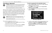
...GPS, RNAV, VOR, NDB, localizer, or ILS) and only the final course segment (usually from final approach fix to missed approach point) of navigation guidance in instrument conditions. The original route is available in the Route tab. Use the ROCKER to select Yes or No, and press ENTER. The GPSMAP 296... approach waypoints. 22 GPSMAP 296 Pilot's Guide Selecting an Approach 4. The GPSMAP 296 is not an IFR-approved instrument and should not be used as described in the Jeppesen database are for the selected approach. BASIC OPERATION IN AVIATION MODE > SELECTING AN...
...GPS, RNAV, VOR, NDB, localizer, or ILS) and only the final course segment (usually from final approach fix to missed approach point) of navigation guidance in instrument conditions. The original route is available in the Route tab. Use the ROCKER to select Yes or No, and press ENTER. The GPSMAP 296... approach waypoints. 22 GPSMAP 296 Pilot's Guide Selecting an Approach 4. The GPSMAP 296 is not an IFR-approved instrument and should not be used as described in the Jeppesen database are for the selected approach. BASIC OPERATION IN AVIATION MODE > SELECTING AN...

Pilot's Guide
Page 31
Active Approach Page Using vectors in the database (final approach fix [FAF]). GPSMAP 296 Pilot's Guide BASIC OPERATION IN AVIATION MODE > SELECTING AN APPROACH If No is selected for the Vectors? This works much like any other route with course guidance from ... Follow the approach plate or air traffic control instructions to complete the approach without a steep turn usually required as you select Yes, the GPSMAP 296 creates an extension of the final approach course using a bold magenta line. If air traffic control clears your approach to an airport...
Active Approach Page Using vectors in the database (final approach fix [FAF]). GPSMAP 296 Pilot's Guide BASIC OPERATION IN AVIATION MODE > SELECTING AN APPROACH If No is selected for the Vectors? This works much like any other route with course guidance from ... Follow the approach plate or air traffic control instructions to complete the approach without a steep turn usually required as you select Yes, the GPSMAP 296 creates an extension of the final approach course using a bold magenta line. If air traffic control clears your approach to an airport...

Pilot's Guide
Page 32
Press the Direct To to show the location on the map, or select OK to return to the search results list. 24 GPSMAP 296 Pilot's Guide The Find Menu opens. For example, if you want to use later when creating a route. Select Save to save the location as the ... "Finding an Item" on page 53 for the category, and press ENTER. 6. BASIC OPERATION IN AVIATION MODE > FINDING POINTS ON LAND Finding Points on Land To take full advantage of the trip-planning capabilities of the GPSMAP 296, you can find a restaurant to eat dinner at when you land. Find Menu 4. Go...
Press the Direct To to show the location on the map, or select OK to return to the search results list. 24 GPSMAP 296 Pilot's Guide The Find Menu opens. For example, if you want to use later when creating a route. Select Save to save the location as the ... "Finding an Item" on page 53 for the category, and press ENTER. 6. BASIC OPERATION IN AVIATION MODE > FINDING POINTS ON LAND Finding Points on Land To take full advantage of the trip-planning capabilities of the GPSMAP 296, you can find a restaurant to eat dinner at when you land. Find Menu 4. Go...
Pilot's Guide
Page 33
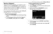
...MENU twice and open the GPS tab to open the Information Page for the map item. Marking a Waypoint Waypoints are locations or landmarks you want to save the waypoint, use the ROCKER to open the Map Page. 2. Press PAGE to view your GPSMAP 296. Use the ROCKER to ...move the arrow to the location you record and store in your satellite receiver status. You must have a valid 2D or 3D satellite fix to create a new waypoint. Press the ENTER/MARK to capture your present location to mark your present location: 1. BASIC OPERATION IN AVIATION...
...MENU twice and open the GPS tab to open the Information Page for the map item. Marking a Waypoint Waypoints are locations or landmarks you want to save the waypoint, use the ROCKER to open the Map Page. 2. Press PAGE to view your GPSMAP 296. Use the ROCKER to ...move the arrow to the location you record and store in your satellite receiver status. You must have a valid 2D or 3D satellite fix to create a new waypoint. Press the ENTER/MARK to capture your present location to mark your present location: 1. BASIC OPERATION IN AVIATION...