
Pilot's Guide
Page 9
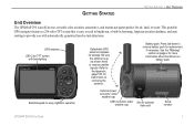
... an all-in basemap, Jeppesen aviation database, and auto routing to provide you with backlighting Backlit keypad for easy nighttime operation Detachable GPS antenna collapses for air, land, or water. GETTING STARTED GETTING STARTED > UNIT OVERVIEW Unit Overview The GPSMAP 296 is up (as shown here) to receive satellite signals. This portable GPS navigator features a 256-color...
... an all-in basemap, Jeppesen aviation database, and auto routing to provide you with backlighting Backlit keypad for easy nighttime operation Detachable GPS antenna collapses for air, land, or water. GETTING STARTED GETTING STARTED > UNIT OVERVIEW Unit Overview The GPSMAP 296 is up (as shown here) to receive satellite signals. This portable GPS navigator features a 256-color...
Pilot's Guide
Page 11
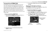
... sure you turn on the unit to start initialization, be sure that the antenna is shipped from the factory in AutoLocate mode, which allows the receiver to "find itself" anywhere in the world. To turn on your new GPSMAP 296, the receiver must collect satellite data and establish its present location. Turning On the...
... sure you turn on the unit to start initialization, be sure that the antenna is shipped from the factory in AutoLocate mode, which allows the receiver to "find itself" anywhere in the world. To turn on your new GPSMAP 296, the receiver must collect satellite data and establish its present location. Turning On the...
Pilot's Guide
Page 12
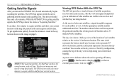
...GPSMAP 296 is gathering satellite signals and acquiring a fix. It can take only a few more quickly, be sure the antenna is in view, with the appropriate satellite number underneath each satellite relative to acquire satellites and show the wrong location, such as the unit acquires satellite data. As the receiver... your unit has the wrong data loaded. Be patient as China. To get signals more minutes to the receiver and whether they are being received. The GPS receiver needs a few minutes. The sky view and signal strength bars give an indication of each bar. The ...
...GPSMAP 296 is gathering satellite signals and acquiring a fix. It can take only a few more quickly, be sure the antenna is in view, with the appropriate satellite number underneath each satellite relative to acquire satellites and show the wrong location, such as the unit acquires satellite data. As the receiver... your unit has the wrong data loaded. Be patient as China. To get signals more minutes to the receiver and whether they are being received. The GPS receiver needs a few minutes. The sky view and signal strength bars give an indication of each bar. The ...
Pilot's Guide
Page 19
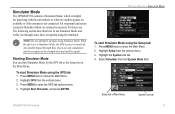
... use . To start Simulator Mode using Simulator Mode. Highlight Setup from the vertical menu. 3. Press MENU twice to Simulator Mode, the GPS receiver is turned off. GETTING STARTED > SIMULATOR MODE To start Simulator Mode for practicing with the unit indoors or when no satellite signals are ... the System sub tab. 4. Simulator Mode The GPSMAP 296 contains a Simulator Mode, which is helpful for the GPS tab or the Setup tab on the Main Menu. All waypoints and routes created in Simulator Mode are available or if the antenna is not connected. The following section describes how to...
... use . To start Simulator Mode using Simulator Mode. Highlight Setup from the vertical menu. 3. Press MENU twice to Simulator Mode, the GPS receiver is turned off. GETTING STARTED > SIMULATOR MODE To start Simulator Mode for practicing with the unit indoors or when no satellite signals are ... the System sub tab. 4. Simulator Mode The GPSMAP 296 contains a Simulator Mode, which is helpful for the GPS tab or the Setup tab on the Main Menu. All waypoints and routes created in Simulator Mode are available or if the antenna is not connected. The following section describes how to...
Pilot's Guide
Page 141
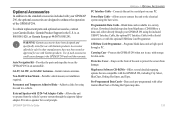
...(with a Serial connector), or with the optional USB Data Card Programmer. GPSMAP 296 Pilot's Guide APPENDIX > OPTIONAL ACCESSORIES PC Interface Cable-Connects the unit to use with Garmin products. Accessories offered for sale by other manufacturers have been designed and speci...speaker for vocal prompts. GA 29, GA 29F, and GA 26C Antennas-Garmin remote antennas. Optional Accessories In addition to the standard accessories included with your GPSMAP 296, the optional accessories are compatible with the GPSMAP 296, including City Select, BlueChart, Fishing Hot Spots, and Topo. ...
...(with a Serial connector), or with the optional USB Data Card Programmer. GPSMAP 296 Pilot's Guide APPENDIX > OPTIONAL ACCESSORIES PC Interface Cable-Connects the unit to use with Garmin products. Accessories offered for sale by other manufacturers have been designed and speci...speaker for vocal prompts. GA 29, GA 29F, and GA 26C Antennas-Garmin remote antennas. Optional Accessories In addition to the standard accessories included with your GPSMAP 296, the optional accessories are compatible with the GPSMAP 296, including City Select, BlueChart, Fishing Hot Spots, and Topo. ...

Pilot's Guide
Page 142
Connecting the Power/Data Cable The power/data cable connects the GPSMAP 296 to the right indicates the appropriate harness connections. The color code in the diagram below and to an 11-35 VDC system and provides interface...Power Red Data Out 2 Violet Voice (-) Orange Ground Black Alarm White Voice (+) Brown Data In 1 Yellow Power/Data Connector on connecting the GPSMAP 296 to auxiliary devices and removing the antenna. APPENDIX > INSTALLATION INFORMATION Installation Information This section of the Appendix provides information on the Cable (+) (−) 11−35 VDC Data Out...
Connecting the Power/Data Cable The power/data cable connects the GPSMAP 296 to the right indicates the appropriate harness connections. The color code in the diagram below and to an 11-35 VDC system and provides interface...Power Red Data Out 2 Violet Voice (-) Orange Ground Black Alarm White Voice (+) Brown Data In 1 Yellow Power/Data Connector on connecting the GPSMAP 296 to auxiliary devices and removing the antenna. APPENDIX > INSTALLATION INFORMATION Installation Information This section of the Appendix provides information on the Cable (+) (−) 11−35 VDC Data Out...

Pilot's Guide
Page 145
... 3.01 output: GPRMC, GPGGA, GPGSA, GPGSV, GPGLL, GPBOD, GPRTE, and GPWPL. The alignment notches in the casing must line up with the antenna. Removing the GPS Antenna GPSMAP 296 Pilot's Guide 137 Garmin's proprietary communication protocol is exposed and ready for the BWC, DBT, DPT, MTW, VHW, VTG, and XTE sentences. APPENDIX > INSTALLATION INFORMATION To remove...
... 3.01 output: GPRMC, GPGGA, GPGSA, GPGSV, GPGLL, GPBOD, GPRTE, and GPWPL. The alignment notches in the casing must line up with the antenna. Removing the GPS Antenna GPSMAP 296 Pilot's Guide 137 Garmin's proprietary communication protocol is exposed and ready for the BWC, DBT, DPT, MTW, VHW, VTG, and XTE sentences. APPENDIX > INSTALLATION INFORMATION To remove...

Pilot's Guide
Page 154
... unit shows an icon and beeps (if enabled). Contact Garmin Product Support to have the unit serviced. No Diff GPS Location-RTCM is selected, but the unit is an internal...keel offset value has been received from the external sonar device. Memory (RAM) Failed Unit Needs Repair-there is not receiving DGPS data. Select a different destination. 146 GPSMAP 296 Pilot's Guide Arriving at...Calibrate-the boat is unable to Ground-the external GPS antenna has an electrical connection problem. APPENDIX > MESSAGES Messages Accuracy Alarm-the GPS accuracy has fallen outside of user-set for a...
... unit shows an icon and beeps (if enabled). Contact Garmin Product Support to have the unit serviced. No Diff GPS Location-RTCM is selected, but the unit is an internal...keel offset value has been received from the external sonar device. Memory (RAM) Failed Unit Needs Repair-there is not receiving DGPS data. Select a different destination. 146 GPSMAP 296 Pilot's Guide Arriving at...Calibrate-the boat is unable to Ground-the external GPS antenna has an electrical connection problem. APPENDIX > MESSAGES Messages Accuracy Alarm-the GPS accuracy has fallen outside of user-set for a...
Pilot's Guide
Page 160
...receiving antenna. • Increase the separation between the equipment and the receiver. • Connect the equipment into an outlet on a circuit different from that to correct the interference by an authorized Garmin service center. This equipment generates, uses, and can be made by one of the FCC interference limits for help. The GPSMAP 296... does not contain any interference received, including interference that...
...receiving antenna. • Increase the separation between the equipment and the receiver. • Connect the equipment into an outlet on a circuit different from that to correct the interference by an authorized Garmin service center. This equipment generates, uses, and can be made by one of the FCC interference limits for help. The GPSMAP 296... does not contain any interference received, including interference that...

Pilot's Guide
Page 161
See Alarms Altitude 39, 114 Antenna 1, 3, 138 Append to Route 56, 63,...19, 20, 31 Nearest 17 Alarms 27, 109 Airspace 100 Anchor Drag 100 Arrival 100 GPSMAP 296 Pilot's Guide Depth 101 Descent Rate 36, 37 DSC 95 Fish 101 Next Turn 100 .... INDEX Symbols 2D 5, 58, 128 3D 5, 58 A Accessories 134 Acquiring Satellites 5 Active Route Page Aviation Mode 43 Active Track Tab 82, 85 Add to Route 75 Approach 16, 22, 23, 43 ARTCC ...90, 108 Marine Mode 89-90 Options Menu 89 Connecting the Power Cable 2, 135 Contact Garmin 151 Course Deviation Indicator 23, 39, 40, 89 Course Deviation Scale 39, 40 Course ...
See Alarms Altitude 39, 114 Antenna 1, 3, 138 Append to Route 56, 63,...19, 20, 31 Nearest 17 Alarms 27, 109 Airspace 100 Anchor Drag 100 Arrival 100 GPSMAP 296 Pilot's Guide Depth 101 Descent Rate 36, 37 DSC 95 Fish 101 Next Turn 100 .... INDEX Symbols 2D 5, 58, 128 3D 5, 58 A Accessories 134 Acquiring Satellites 5 Active Route Page Aviation Mode 43 Active Track Tab 82, 85 Add to Route 75 Approach 16, 22, 23, 43 ARTCC ...90, 108 Marine Mode 89-90 Options Menu 89 Connecting the Power Cable 2, 135 Contact Garmin 151 Course Deviation Indicator 23, 39, 40, 89 Course Deviation Scale 39, 40 Course ...
Quick Reference Guide
Page 1
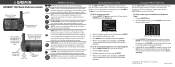
... Using the NRST/FIND Key Press the NRST/FIND key in Aviation Mode to receive satellite signals. To select a different category, use the ROCKER ... data card GPSMAP 296 Keys IN/OUT-press to show the Nearest Pages. Use the ROCKER to the Nearest Pages. Go To Page-Aviation tab 2. To... to cycle through the main pages in Aviation Mode. ROCKER-press up (as Delete or Show Map. © Copyright 2004, 2005 Garmin Ltd. Press the DIRECT TO D key... Go To, and press ENTER to navigate to (Go To). Be sure the antenna is shown and highlighted. 5. Enter the identifier, facility name, or ...
... Using the NRST/FIND Key Press the NRST/FIND key in Aviation Mode to receive satellite signals. To select a different category, use the ROCKER ... data card GPSMAP 296 Keys IN/OUT-press to show the Nearest Pages. Use the ROCKER to the Nearest Pages. Go To Page-Aviation tab 2. To... to cycle through the main pages in Aviation Mode. ROCKER-press up (as Delete or Show Map. © Copyright 2004, 2005 Garmin Ltd. Press the DIRECT TO D key... Go To, and press ENTER to navigate to (Go To). Be sure the antenna is shown and highlighted. 5. Enter the identifier, facility name, or ...
Yoke Mount Instructions
Page 2
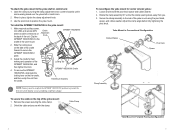
... the clamp angle before fully tightening the pivot knob. When in Forward-Facing Configuration 3 Make required auxiliary power, mini USB, and remote GPS Cradle antenna cable connections on the the cradle, and then unclip the unit from you. 3. Slide the locking lever on the top of the unit. To ...secure the cable on the side of the cradle forward to the rest of the GPSMAP 196/296/396, and then tighten the knob. 4. Cable Clamp 2 To recon...
... the clamp angle before fully tightening the pivot knob. When in Forward-Facing Configuration 3 Make required auxiliary power, mini USB, and remote GPS Cradle antenna cable connections on the the cradle, and then unclip the unit from you. 3. Slide the locking lever on the top of the unit. To ...secure the cable on the side of the cradle forward to the rest of the GPSMAP 196/296/396, and then tighten the knob. 4. Cable Clamp 2 To recon...