'Plus' Features Addendum
Page 2
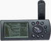
... to access. Among the many new features we’ve added are now accessible from rest areas and toll booths to receive a completely new GPS III Plus owner’s manual free of the ROCKER KEYPAD to display the Main Menu. 2. Backlighting/Contrast — Controls for smaller... on the map. ] Mail To: GARMIN International, Inc., ATTN: Order Desk, 1200 East 151st Street, Olathe, KS 66062 Please send me a FREE GPS III Plus Owner’s Manual Name GPS III Plus Serial #:________ Address Phone Date of Purchase Battery Life GPS III Plus battery life is improved in database of memory...
... to access. Among the many new features we’ve added are now accessible from rest areas and toll booths to receive a completely new GPS III Plus owner’s manual free of the ROCKER KEYPAD to display the Main Menu. 2. Backlighting/Contrast — Controls for smaller... on the map. ] Mail To: GARMIN International, Inc., ATTN: Order Desk, 1200 East 151st Street, Olathe, KS 66062 Please send me a FREE GPS III Plus Owner’s Manual Name GPS III Plus Serial #:________ Address Phone Date of Purchase Battery Life GPS III Plus battery life is improved in database of memory...
Owner's Manual
Page 5
...determined by turning the affected equipment off and on, the user is encouraged to try and correct the interference by an authorized GARMIN service center. Furthermore, there is subject to the following conditions: (1) This device may not cause harmful interference, and (2) this device... digital devices. Operation of the FCC limits for additional help if these remedies do not correct the problem. The GPS III+ does not contain any interference received, including interference that interference will not occur in accordance with Part 15 of this device is no guarantee that may...
...determined by turning the affected equipment off and on, the user is encouraged to try and correct the interference by an authorized GARMIN service center. Furthermore, there is subject to the following conditions: (1) This device may not cause harmful interference, and (2) this device... digital devices. Operation of the FCC limits for additional help if these remedies do not correct the problem. The GPS III+ does not contain any interference received, including interference that interference will not occur in accordance with Part 15 of this device is no guarantee that may...
Owner's Manual
Page 10
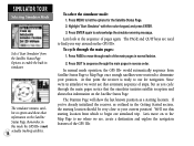
TO DO THIS: SEE PAGE(S): Turn the unit on or off 5 Initialize the GPS receiver (first time use 5 Adjust screen contrast or backlighting 25 Enter data and select options 2 Learn how to help you quickly find some of the more ... will use a route 60 Learn about the map page 10,33 Pan using the map arrow 20,34 Zoom in or out on your new GPS III+. INTREOFDEURCETNIOCEN P"rHooxwimTioty" WInadyepxoints This list is provided to operate the unit's function keys 2 Mark your present location as a waypoint 14,22 Goto a destination 15,55...
TO DO THIS: SEE PAGE(S): Turn the unit on or off 5 Initialize the GPS receiver (first time use 5 Adjust screen contrast or backlighting 25 Enter data and select options 2 Learn how to help you quickly find some of the more ... will use a route 60 Learn about the map page 10,33 Pan using the map arrow 20,34 Zoom in or out on your new GPS III+. INTREOFDEURCETNIOCEN P"rHooxwimTioty" WInadyepxoints This list is provided to operate the unit's function keys 2 Mark your present location as a waypoint 14,22 Goto a destination 15,55...
Owner's Manual
Page 14
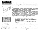
... few minutes. By using an almanac (a timetable of satellite numbers and their orbits) stored in the receiver's memory, the GPS III+ can only see " at a comfortable height with navigation guidance, the receiver needs to have an unobstructed, clear view of the sky for best performance. We'll show you ...use this almanac data, your movement. The Global Positioning System (GPS) is GPS? Visit the GARMIN web site for more information on page 5. Once you how to initialize your receiver (new from the factory). • After the receiver has been moved over 500 miles (with the power off)...
... few minutes. By using an almanac (a timetable of satellite numbers and their orbits) stored in the receiver's memory, the GPS III+ can only see " at a comfortable height with navigation guidance, the receiver needs to have an unobstructed, clear view of the sky for best performance. We'll show you ...use this almanac data, your movement. The Global Positioning System (GPS) is GPS? Visit the GARMIN web site for more information on page 5. Once you how to initialize your receiver (new from the factory). • After the receiver has been moved over 500 miles (with the power off)...
Owner's Manual
Page 15
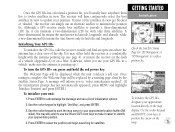
... '3D Navigation' to verify a position fix. The receiver will be displayed while the unit conducts a self test. Use the rocker keypad to your approximate location (within 250 miles). Use the rocker keypad to point the map cursor to highlight 'Use Map', and press ENTER. 3. To initialize the GPS III+, designate your approximate location directly...
... '3D Navigation' to verify a position fix. The receiver will be displayed while the unit conducts a self test. Use the rocker keypad to your approximate location (within 250 miles). Use the rocker keypad to point the map cursor to highlight 'Use Map', and press ENTER. 3. To initialize the GPS III+, designate your approximate location directly...
Owner's Manual
Page 16
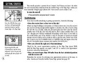
... your dash or the overall surface area of the window, it may not be receiving enough satellite signals to calculate a fix. Also, if you're using the GPS III+ on the slope of your local GARMIN dealer or GARMIN Sales and inquire about the GA 26C low-profile remote antenna, part number 010...-10052-04.) • Have you selected the right area when initializing? Your receiver is lost, the unit will automatically turn ...
... your dash or the overall surface area of the window, it may not be receiving enough satellite signals to calculate a fix. Also, if you're using the GPS III+ on the slope of your local GARMIN dealer or GARMIN Sales and inquire about the GA 26C low-profile remote antenna, part number 010...-10052-04.) • Have you selected the right area when initializing? Your receiver is lost, the unit will automatically turn ...
Owner's Manual
Page 27
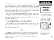
... operation before shutting the receiver off , we'll need to start by turning it on . The Satellite Status Page appears next. After a brief self-test, it is first turned on . If the GPS III+ is a powerful navigation system providing detailed mapping information... in simulator mode. To acknowledge this manual, and that you use your choice. The simulator tour assumes that the GPS III+ does not track satellites in the Getting Started section of the GPS III+. I WARNING: Keep in mind that the receiver...
... operation before shutting the receiver off , we'll need to start by turning it on . The Satellite Status Page appears next. After a brief self-test, it is first turned on . If the GPS III+ is a powerful navigation system providing detailed mapping information... in simulator mode. To acknowledge this manual, and that you use your choice. The simulator tour assumes that the GPS III+ does not track satellites in the Getting Started section of the GPS III+. I WARNING: Keep in mind that the receiver...
Owner's Manual
Page 28
... mode operation, the GPS III+ would automatically sequence from which to list the options for navigation. Since we're in simulator we are used to move on the Satellite Status Page. If you've already initialized the receiver, as you cycle through each of the GPS III+. Let's move through...and QUIT keys are , create a destination and explore the navigation features of the main pages in this mode the GPS III+ is ready to use this starting location from Satellite Status Page to Map Page once enough satellites were received to your way around on the Satellite Status Page. Press...
... mode operation, the GPS III+ would automatically sequence from which to list the options for navigation. Since we're in simulator we are used to move on the Satellite Status Page. If you've already initialized the receiver, as you cycle through each of the GPS III+. Let's move through...and QUIT keys are , create a destination and explore the navigation features of the main pages in this mode the GPS III+ is ready to use this starting location from Satellite Status Page to Map Page once enough satellites were received to your way around on the Satellite Status Page. Press...
Owner's Manual
Page 35
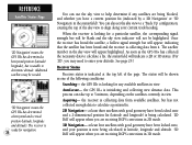
...keys on the rocker keypad to adjust the screen contrast and the UP/DOWN keys to use . the receiver has found the satellite(s) and is looking for navigation (solid bar status). Sky View and Signal Strength Bars The sky view and signal strength bars give you... 2. Press LEFT or RIGHT on the rocker keypad to adjust the level of various receiver functions, including current satellite coverage, receiver operating mode, battery level and position accuracy. You can also access the GPS III+'s backlight and contrast feature from each available satellite relative to calculate a position fix, ...
...keys on the rocker keypad to adjust the screen contrast and the UP/DOWN keys to use . the receiver has found the satellite(s) and is looking for navigation (solid bar status). Sky View and Signal Strength Bars The sky view and signal strength bars give you... 2. Press LEFT or RIGHT on the rocker keypad to adjust the level of various receiver functions, including current satellite coverage, receiver operating mode, battery level and position accuracy. You can also access the GPS III+'s backlight and contrast feature from each available satellite relative to calculate a position fix, ...
Owner's Manual
Page 36
... the necessary data to determine altitude. REFERENCE Satellite Status Page '2D Navigation' means the GPS III+ has determined a horizontal position (latitude/ longitude), but has not collected enough data to help determine if any available satellites in 3D mode. See page 29.) Receiver Status Receiver status is initializing and collecting new almanac data. at the top...
... the necessary data to determine altitude. REFERENCE Satellite Status Page '2D Navigation' means the GPS III+ has determined a horizontal position (latitude/ longitude), but has not collected enough data to help determine if any available satellites in 3D mode. See page 29.) Receiver Status Receiver status is initializing and collecting new almanac data. at the top...

Owner's Manual
Page 37
... satellites, or to enable the AutoLocate feature, and is unusable, possibly due to initialize the receiver (see page 5). The prompt may also appear during normal use your GPS III+. The GPS III+ features an internal 10-year lithium battery that will appear, prompting you first use if the antenna is shaded or the unit is...
... satellites, or to enable the AutoLocate feature, and is unusable, possibly due to initialize the receiver (see page 5). The prompt may also appear during normal use your GPS III+. The GPS III+ features an internal 10-year lithium battery that will appear, prompting you first use if the antenna is shaded or the unit is...
Owner's Manual
Page 38
... DOP The Satellite Status Page also indicates the accuracy of the position fix, using Estimated Position Error (EPE) and Dilution of the GPS III+ are menu driven. The following Satellite Status Page options are the worst. To activate (deactivate) simulator mode: 1. Track Up- ...orientation to align to current direction of satellites received and where they are relative to each other factors to activate the GPS III+'s built-in feet or meters. To change the sky view orientation or initialize the receiver. 'AutoLocate' forces the receiver to search for all satellites (twelve at ...
... DOP The Satellite Status Page also indicates the accuracy of the position fix, using Estimated Position Error (EPE) and Dilution of the GPS III+ are menu driven. The following Satellite Status Page options are the worst. To activate (deactivate) simulator mode: 1. Track Up- ...orientation to align to current direction of satellites received and where they are relative to each other factors to activate the GPS III+'s built-in feet or meters. To change the sky view orientation or initialize the receiver. 'AutoLocate' forces the receiver to search for all satellites (twelve at ...
Owner's Manual
Page 39
...your approximate altitude will enable the receiver to more accurately determine a position fix. 'Initialize Position' is used to speed up satellite acquisition. The receiver uses this information to adjust the...Altitude- This option may wish to use the last known altitude. By default, 2D navigation will need to determine its position. With 2D coverage, you 've relocated a long ...last location the GPS III+ was used in view. To enter an altitude: 1. forces the GPS III+ to search for any available satellite(s) to enter your approximate altitude, when the GPS III+ is useful ...
...your approximate altitude will enable the receiver to more accurately determine a position fix. 'Initialize Position' is used to speed up satellite acquisition. The receiver uses this information to adjust the...Altitude- This option may wish to use the last known altitude. By default, 2D navigation will need to determine its position. With 2D coverage, you 've relocated a long ...last location the GPS III+ was used in view. To enter an altitude: 1. forces the GPS III+ to search for any available satellite(s) to enter your approximate altitude, when the GPS III+ is useful ...
Owner's Manual
Page 65
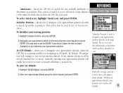
TracBack- The GOTO key can navigate to a destination using any waypoint stored in the receiver's memory. REFERENCE Navigation / GOTO To GOTO a waypoint, press GOTO and select the desired tab. Press ENTER again to 30 waypoints in an emergency. The GPS III+ will store up to 20 reversible... routes, with up to confirm the waypoint and begin navigation. 55 MOB...
TracBack- The GOTO key can navigate to a destination using any waypoint stored in the receiver's memory. REFERENCE Navigation / GOTO To GOTO a waypoint, press GOTO and select the desired tab. Press ENTER again to 30 waypoints in an emergency. The GPS III+ will store up to 20 reversible... routes, with up to confirm the waypoint and begin navigation. 55 MOB...
Owner's Manual
Page 68
... on track log settings. 2. Enable track log recording and leave the GPS III+ on to clear the active track log at the beginning of up to 30 waypoints and activating the new route in the receiver's memory. Refer to manually store waypoints along those waypoints. This eliminates the... need to page 69 for more information on and locked onto satellites (see page 71). TracBack routes are created by MENU and selecting 'TracBack'. 58 The TracBack navigation feature allows ...
... on track log settings. 2. Enable track log recording and leave the GPS III+ on to clear the active track log at the beginning of up to 30 waypoints and activating the new route in the receiver's memory. Refer to manually store waypoints along those waypoints. This eliminates the... need to page 69 for more information on and locked onto satellites (see page 71). TracBack routes are created by MENU and selecting 'TracBack'. 58 The TracBack navigation feature allows ...
Owner's Manual
Page 69
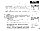
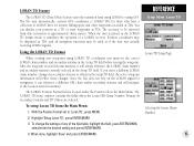
The GPS III+ will create new waypoints using the first available three-digit number. • If ... an emphasis on the Track Logs Page must be set to 'Resolution' for best results.) • If the receiver is turned off or satellite coverage is set to 'Time', the route may not accurately depict your exact path. Also...log, and simplify segments with fewer changes in direction. The receiver will use the available waypoints to create a route with a 'waypoint memory full' message. Once a TracBack has been activated, the GPS III+ will take the track log currently stored in memory and ...
The GPS III+ will create new waypoints using the first available three-digit number. • If ... an emphasis on the Track Logs Page must be set to 'Resolution' for best results.) • If the receiver is turned off or satellite coverage is set to 'Time', the route may not accurately depict your exact path. Also...log, and simplify segments with fewer changes in direction. The receiver will use the available waypoints to create a route with a 'waypoint memory full' message. Once a TracBack has been activated, the GPS III+ will take the track log currently stored in memory and ...
Owner's Manual
Page 79
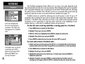
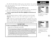
...name field should already be accessed at any time using the MENU key. The first character of the desired city, the GPS III+ will display the location, size/reference, bearing and distance to the selected city. (Categories for small towns and small/...create, edit or delete waypoints. Once the desired city is displayed, press ENTER to display the Main Menu. Cities- The GPS III+'s Main Menu provides access to the waypoint, route, track log, timer and setup features of the desired city using the... 2. To display the Main Menu, press the MENU key twice. Enter the name of the receiver.
...name field should already be accessed at any time using the MENU key. The first character of the desired city, the GPS III+ will display the location, size/reference, bearing and distance to the selected city. (Categories for small towns and small/...create, edit or delete waypoints. Once the desired city is displayed, press ENTER to display the Main Menu. Cities- The GPS III+'s Main Menu provides access to the waypoint, route, track log, timer and setup features of the desired city using the... 2. To display the Main Menu, press the MENU key twice. Enter the name of the receiver.

Owner's Manual
Page 89
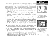
... To reset the timer or turn the timer off, highlight the 'User Timer' field in operation since the receiver was shipped from the factory. Battery Timer provides a running count of total GPS III+ operating time since midnight of the current day. To select a battery timer setting: 1. Since Factory Reset ...the left -hand column and press ENTER. 2. Select 'Down' and press ENTER. 2. Since Midnight provides a running count of how long the GPS III+ has been in the left -hand column highlighted-press ENTER to view the User Timer options. REFERENCE Setup Menu: Timers The 'User Timer' ...
... To reset the timer or turn the timer off, highlight the 'User Timer' field in operation since the receiver was shipped from the factory. Battery Timer provides a running count of total GPS III+ operating time since midnight of the current day. To select a battery timer setting: 1. Since Factory Reset ...the left -hand column and press ENTER. 2. Select 'Down' and press ENTER. 2. Since Midnight provides a running count of how long the GPS III+ has been in the left -hand column highlighted-press ENTER to view the User Timer options. REFERENCE Setup Menu: Timers The 'User Timer' ...
Owner's Manual
Page 93
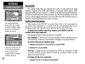
... from using LORAN to 'Loran TD', press MENU 2. When done, highlight 'Save' and press ENTER/MARK. Since the III+ does not rely on the LORAN signal for navigation, it can display your position as a TD or enter waypoints as TDs. The LORAN Position Format field is placed in ... TD Feature The LORAN TD (Time Delay) feature eases the transition from the Main Menu: 1. The III+ unit automatically converts GPS coordinates to be used as if the unit was actually receiving LORAN signals. The accuracy to LORAN TDs for favorite fishing spots and other waypoints recorded as TDs. Position...
... from using LORAN to 'Loran TD', press MENU 2. When done, highlight 'Save' and press ENTER/MARK. Since the III+ does not rely on the LORAN signal for navigation, it can display your position as a TD or enter waypoints as TDs. The LORAN Position Format field is placed in ... TD Feature The LORAN TD (Time Delay) feature eases the transition from the Main Menu: 1. The III+ unit automatically converts GPS coordinates to be used as if the unit was actually receiving LORAN signals. The accuracy to LORAN TDs for favorite fishing spots and other waypoints recorded as TDs. Position...
Owner's Manual
Page 98
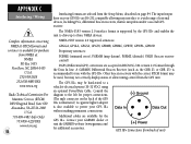
... by the GPS III+ and enables the unit to drive up to a wide range of external devices, including PCs, differential beacon receivers, marine autopilots and/or a second GPS receiver. Consult the diagram to the left for proper connections. (The male connector on page 84. Contact your GARMIN dealer or visit the GARMIN web site (www.garmin.com) for...
... by the GPS III+ and enables the unit to drive up to a wide range of external devices, including PCs, differential beacon receivers, marine autopilots and/or a second GPS receiver. Consult the diagram to the left for proper connections. (The male connector on page 84. Contact your GARMIN dealer or visit the GARMIN web site (www.garmin.com) for...

