Pilots Guide
Page 5
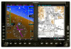
... navigation sources, including the information from the G500 to the G500. Thoroughly practice basic operation prior to the G500. WARNING: Exceeding 200 deg/second in data transmission and the relative age of the G500 Pilot's Guide. B Garmin G500 Pilot's Guide iii Due to inherent delays in ...carefully compare indications from other NAVAIDs, visual sightings, charts, etc. Both the FAA Advisory Circular, Subject: Thunderstorms, and the Airman's Information Manual (AIM) recommend avoiding "by the GDL 69/69A is provided as severe or giving an intense radar echo." Sec 6 Annun. & ...
... navigation sources, including the information from the G500 to the G500. Thoroughly practice basic operation prior to the G500. WARNING: Exceeding 200 deg/second in data transmission and the relative age of the G500 Pilot's Guide. B Garmin G500 Pilot's Guide iii Due to inherent delays in ...carefully compare indications from other NAVAIDs, visual sightings, charts, etc. Both the FAA Advisory Circular, Subject: Thunderstorms, and the Airman's Information Manual (AIM) recommend avoiding "by the GDL 69/69A is provided as severe or giving an intense radar echo." Sec 6 Annun. & ...
Pilots Guide
Page 31
...5 Additional Sec 6 Annun. & Alerts Sec 7 Symbols Sec 8 Glossary Appendix A Appendix B Index 190-01102-02 Rev. B Garmin G500 Pilot's Guide 1-15 The G500 System is prompted to continue. The AHRS can align itself both power-on the GDU 620 display bezel. The GDU 620 and supporting ... Sec 1 System Sec 2 PFD Sec 3 MFD Sec 4 Hazard Avoidance Features 1.2 System Power Up NOTE: See the Aircraft Flight Manual (AFM) for system-specific annunciations and alerts. The AHRS should disappear typically within the first minute after power-up . All system ...
...5 Additional Sec 6 Annun. & Alerts Sec 7 Symbols Sec 8 Glossary Appendix A Appendix B Index 190-01102-02 Rev. B Garmin G500 Pilot's Guide 1-15 The G500 System is prompted to continue. The AHRS can align itself both power-on the GDU 620 display bezel. The GDU 620 and supporting ... Sec 1 System Sec 2 PFD Sec 3 MFD Sec 4 Hazard Avoidance Features 1.2 System Power Up NOTE: See the Aircraft Flight Manual (AFM) for system-specific annunciations and alerts. The AHRS should disappear typically within the first minute after power-up . All system ...

Pilots Guide
Page 33
...in the GRS 77. Foreword Sec 1 System Sec 2 PFD Sec 3 MFD Sec 4 Hazard Avoidance Features Sec 5 Additional Figure 1-18 - B Garmin G500 Pilot's Guide 1-17 At system power-up, the IGRF models in the GRS 77 and in the Navigation Database are compared, and if the IGRF model...information and displays the Navigation Map Page. The following prompt will appear after the G500 splash screen is only updated once every five years. Autopilot Automatically Disconnected Fly the aircraft manually and crosscheck the GDU 620 attitude indication with the standby attitude indicator and other ...
...in the GRS 77. Foreword Sec 1 System Sec 2 PFD Sec 3 MFD Sec 4 Hazard Avoidance Features Sec 5 Additional Figure 1-18 - B Garmin G500 Pilot's Guide 1-17 At system power-up, the IGRF models in the GRS 77 and in the Navigation Database are compared, and if the IGRF model...information and displays the Navigation Map Page. The following prompt will appear after the G500 splash screen is only updated once every five years. Autopilot Automatically Disconnected Fly the aircraft manually and crosscheck the GDU 620 attitude indication with the standby attitude indicator and other ...

Pilots Guide
Page 37
... displays and bezel keys can be adjusted automatically or manually. Manual backlighting adjustment can be accomplished using the existing instrument panel dimmer bus or the following procedures. Sec 5 Additional Sec 6 Annun. & Alerts Sec 7 Symbols Sec 8 Glossary Appendix A Appendix B Index 190-01102-02 Rev. B Garmin G500 Pilot's Guide 1-21 Photocell calibration curves are pre-configured to...
... displays and bezel keys can be adjusted automatically or manually. Manual backlighting adjustment can be accomplished using the existing instrument panel dimmer bus or the following procedures. Sec 5 Additional Sec 6 Annun. & Alerts Sec 7 Symbols Sec 8 Glossary Appendix A Appendix B Index 190-01102-02 Rev. B Garmin G500 Pilot's Guide 1-21 Photocell calibration curves are pre-configured to...
Pilots Guide
Page 38
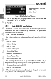
B Turn the small MFD knob to select "AUTO" or "MANUAL." 4) Press ENT. 1.3.5 Dual GDU 620 Installations Dual GDU 620 units when connected in the aircraft may be set up to communicate and share ...changed independently, depending on both GDUs. & Alerts Annun. Sec 6 Symbols Sec 7 Appendix A Glossary Sec 8 Index Appendix B 1-22 Garmin G500 Pilot's Guide 190-01102-02 Rev. Foreword Manual Adjustment 0.1% to 50% or Auto (1.7%) Auto or Manual System Sec 1 PFD Sec 2 MFD Sec 3 Features Avoidance Hazard Sec 4 Additional Sec 5 Figure 1-22 Display Brightness Adjustment 3) Turn ...
B Turn the small MFD knob to select "AUTO" or "MANUAL." 4) Press ENT. 1.3.5 Dual GDU 620 Installations Dual GDU 620 units when connected in the aircraft may be set up to communicate and share ...changed independently, depending on both GDUs. & Alerts Annun. Sec 6 Symbols Sec 7 Appendix A Glossary Sec 8 Index Appendix B 1-22 Garmin G500 Pilot's Guide 190-01102-02 Rev. Foreword Manual Adjustment 0.1% to 50% or Auto (1.7%) Auto or Manual System Sec 1 PFD Sec 2 MFD Sec 3 Features Avoidance Hazard Sec 4 Additional Sec 5 Figure 1-22 Display Brightness Adjustment 3) Turn ...

Pilots Guide
Page 79
... Auto Zoom feature will also automatically zoom to the SafeTaxi zoom range when the aircraft is on the ground. B Garmin G500 Pilot's Guide 3-15 Auto Zoom can be overridden at any time by manually zooming with the RNG keys or enabling OBS mode. If enabled, it will automatically change the Navigation Map range depending... on the distance to "in air," 3) a point is reached where the Auto Zoom range matches the manual override range (known as auto-sync), 4) Auto Zoom is toggled of and back on in the flight plan.
... Auto Zoom feature will also automatically zoom to the SafeTaxi zoom range when the aircraft is on the ground. B Garmin G500 Pilot's Guide 3-15 Auto Zoom can be overridden at any time by manually zooming with the RNG keys or enabling OBS mode. If enabled, it will automatically change the Navigation Map range depending... on the distance to "in air," 3) a point is reached where the Auto Zoom range matches the manual override range (known as auto-sync), 4) Auto Zoom is toggled of and back on in the flight plan.
Pilots Guide
Page 107
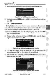
... MFD knob to activate the cursor. 2) The Level will be highlighted. The manual mode allows the setting of display brightness between 0 and 100%. 1) Turn the large MFD knob to manual or automatic. B Garmin G500 Pilot's Guide 3-43 If you press ENT the Mode setting will set to reach ...the AUX page group. Figure 3-65 Aux Mode Display Brightness Level Selection 3) If the Level was changed, Manual will be selected. Press the small ...
... MFD knob to activate the cursor. 2) The Level will be highlighted. The manual mode allows the setting of display brightness between 0 and 100%. 1) Turn the large MFD knob to manual or automatic. B Garmin G500 Pilot's Guide 3-43 If you press ENT the Mode setting will set to reach ...the AUX page group. Figure 3-65 Aux Mode Display Brightness Level Selection 3) If the Level was changed, Manual will be selected. Press the small ...

Pilots Guide
Page 153
..." radar similar to the ATCRBS. Whenever the structure of the client aircraft comes between the aircraft and the Mode S radar. B Garmin G500 Pilot's Guide 4-25 TIS is a useful aid to visual traffic avoidance, it has some system limitations that provided to ATC. TIS should...Mode S radar, which is intended only to assist in VMC. Many of the Aeronautical Information Manual, Section 1-3-5. In other times when there is not comprehensive. Garmin recommends the user review the TIS Limitations section of these limitations are described in secondary radar surveillance....
..." radar similar to the ATCRBS. Whenever the structure of the client aircraft comes between the aircraft and the Mode S radar. B Garmin G500 Pilot's Guide 4-25 TIS is a useful aid to visual traffic avoidance, it has some system limitations that provided to ATC. TIS should...Mode S radar, which is intended only to assist in VMC. Many of the Aeronautical Information Manual, Section 1-3-5. In other times when there is not comprehensive. Garmin recommends the user review the TIS Limitations section of these limitations are described in secondary radar surveillance....

Pilots Guide
Page 154
... may report incorrect horizontal position until the maneuvering aircraft stabilizes. • When a rapidly closing intruder is collected one radar scan prior to the Aeronautical Information Manual for Mode S geographical coverage. Occasionally, aircraft maneuvering will be used to present the intruders in a "real time" position, the TIS ground station uses a "... algorithm uses track history data to extrapolate intruders to induce errors in "see and avoid." Sec 6 Symbols Sec 7 Appendix A Glossary Sec 8 Index Appendix B 4-26 Garmin G500 Pilot's Guide 190-01102-02 Rev.
... may report incorrect horizontal position until the maneuvering aircraft stabilizes. • When a rapidly closing intruder is collected one radar scan prior to the Aeronautical Information Manual for Mode S geographical coverage. Occasionally, aircraft maneuvering will be used to present the intruders in a "real time" position, the TIS ground station uses a "... algorithm uses track history data to extrapolate intruders to induce errors in "see and avoid." Sec 6 Symbols Sec 7 Appendix A Glossary Sec 8 Index Appendix B 4-26 Garmin G500 Pilot's Guide 190-01102-02 Rev.
Pilots Guide
Page 157
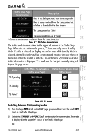
...stream FAILED* The transponder has failed UNAVAILABLE TIS is unavailable or out of range * Contact a service center or Garmin dealer for display on the ground, TIS automatically enters Standby Mode. Once the aircraft is airborne, TIS switches to...the traffic display enabled icon is displayed in center of the Traffic Map Page. The mode can be changed manually using soft keys or the page menu. Mode Traffic Mode Annunciation Traffic Display Enabled Icon (Traffic Map Page... in the upper left corner of the Traffic Map Page. B Garmin G500 Pilot's Guide 4-29 Index If traffic is displayed.
...stream FAILED* The transponder has failed UNAVAILABLE TIS is unavailable or out of range * Contact a service center or Garmin dealer for display on the ground, TIS automatically enters Standby Mode. Once the aircraft is airborne, TIS switches to...the traffic display enabled icon is displayed in center of the Traffic Map Page. The mode can be changed manually using soft keys or the page menu. Mode Traffic Mode Annunciation Traffic Display Enabled Icon (Traffic Map Page... in the upper left corner of the Traffic Map Page. B Garmin G500 Pilot's Guide 4-29 Index If traffic is displayed.

Pilots Guide
Page 181
... line with blue triangles that point in the Page Menu Weather Setup options. The Forecast Time menu item will step through the intervals manually. Cold Front A Warm Front is where warm air replaces cold air. When enabled, the Surface Analysis forecast shows frontal lines indicating weather... of 12, 24, 36, and 48 hours by pressing the SRFC TIME soft key or in the direction of the warm air flow. B Garmin G500 Pilot's Guide 4-53 Appendix B Index Foreword Sec 1 System 4.7.15 Surface Analysis and City Forecast NOTE: Surface Analysis and City Forecast data are noted ...
... line with blue triangles that point in the Page Menu Weather Setup options. The Forecast Time menu item will step through the intervals manually. Cold Front A Warm Front is where warm air replaces cold air. When enabled, the Surface Analysis forecast shows frontal lines indicating weather... of 12, 24, 36, and 48 hours by pressing the SRFC TIME soft key or in the direction of the warm air flow. B Garmin G500 Pilot's Guide 4-53 Appendix B Index Foreword Sec 1 System 4.7.15 Surface Analysis and City Forecast NOTE: Surface Analysis and City Forecast data are noted ...

Pilots Guide
Page 206
...Sec 4 Additional Sec 5 & Alerts Annun. This displays the Tilt Line. This displays the Tilt Line. 2) Press the MFD knob to highlight "Manual Gain" and press ENT. Remember to return the gain setting to : "Calibrated" for viewing the actual intensity of precipitation. 1) While viewing the Weather... Vertical Scan view, press the CONTROL and then the TILT soft keys. Symbols Sec 7 Appendix A Glossary Sec 8 Index Appendix B 4-78 Garmin G500 Pilot's Guide 190-01102-02 Rev. B It can be displayed as a color not representative of the returns from the surface. OR Press MENU ...
...Sec 4 Additional Sec 5 & Alerts Annun. This displays the Tilt Line. This displays the Tilt Line. 2) Press the MFD knob to highlight "Manual Gain" and press ENT. Remember to return the gain setting to : "Calibrated" for viewing the actual intensity of precipitation. 1) While viewing the Weather... Vertical Scan view, press the CONTROL and then the TILT soft keys. Symbols Sec 7 Appendix A Glossary Sec 8 Index Appendix B 4-78 Garmin G500 Pilot's Guide 190-01102-02 Rev. B It can be displayed as a color not representative of the returns from the surface. OR Press MENU ...

Pilots Guide
Page 238
Please refer to your particular autopilot manual for three seconds after the knob stops moving. 2) Engage your autopilot in much the same was as a typical HSI. B Index Appendix B 5-26 Garmin G500 Pilot's Guide 190-01102-02 Rev. When the PFD knob is turned, the Selected Heading box ...Press the HDG key on the autopilot controller) and capture the selected altitude. Foreword System Sec 1 PFD Sec 2 5.6 Autopilot Operation The G500 is able to interface to certain autopilot systems to provide heading, course, and navigation information in Heading Hold mode. 3) Continue to control ...
Please refer to your particular autopilot manual for three seconds after the knob stops moving. 2) Engage your autopilot in much the same was as a typical HSI. B Index Appendix B 5-26 Garmin G500 Pilot's Guide 190-01102-02 Rev. When the PFD knob is turned, the Selected Heading box ...Press the HDG key on the autopilot controller) and capture the selected altitude. Foreword System Sec 1 PFD Sec 2 5.6 Autopilot Operation The G500 is able to interface to certain autopilot systems to provide heading, course, and navigation information in Heading Hold mode. 3) Continue to control ...

Pilots Guide
Page 269
...Garmin G500 Pilot's Guide 8-1 Foreword Sec 1 System Sec 2 PFD Sec 3 MFD 8 Glossary ACT, ACTV ADC ADF ADI AFM AFMS AGL AHRS AIM AIRMET ALT AP APR APT ARINC ARSPC ARTCC AS ASOS ATC ATCRBS ATIS AUX AWOS active, activate Air Data Computer Automatic Direction Finder Attitude Direction Indicator Airplane Flight Manual Airplane Flight Manual... Supplement Above Ground Level Attitude and Heading Reference System Airman's Information Manual Airman's Meteorological Information altitude autopilot approach ...
...Garmin G500 Pilot's Guide 8-1 Foreword Sec 1 System Sec 2 PFD Sec 3 MFD 8 Glossary ACT, ACTV ADC ADF ADI AFM AFMS AGL AHRS AIM AIRMET ALT AP APR APT ARINC ARSPC ARTCC AS ASOS ATC ATCRBS ATIS AUX AWOS active, activate Air Data Computer Automatic Direction Finder Attitude Direction Indicator Airplane Flight Manual Airplane Flight Manual... Supplement Above Ground Level Attitude and Heading Reference System Airman's Information Manual Airman's Meteorological Information altitude autopilot approach ...


