
Pilots Guide
Page 2
..., Olathe, KS 66062, U.S.A. NavData® is a trademark of Garmin Ltd. This manual reflects the operation of Jeppesen, Inc.; Garmin®, FliteCharts®, and SafeTaxi® are registered trademarks of Garmin Ltd. © 2009 Garmin Ltd. For comments about this guide, please e-mail: Techpubs.Salem@Garmin.com www.garmin.com Except as expressly provided herein, no part of...
..., Olathe, KS 66062, U.S.A. NavData® is a trademark of Garmin Ltd. This manual reflects the operation of Jeppesen, Inc.; Garmin®, FliteCharts®, and SafeTaxi® are registered trademarks of Garmin Ltd. © 2009 Garmin Ltd. For comments about this guide, please e-mail: Techpubs.Salem@Garmin.com www.garmin.com Except as expressly provided herein, no part of...
Pilots Guide
Page 5
...North of 70° North latitude and south of 55° South latitude between longitude 75° West and 120° West. B Garmin G500 Pilot's Guide iii WARNING: To reduce the risk of unsafe operation, carefully review and understand all available navigation sources, including the information from ... or roll may invalidate ADC information provided to the G500. Both the FAA Advisory Circular, Subject: Thunderstorms, and the Airman's Information Manual (AIM) recommend avoiding "by the GDL 69/69A is to be learned on the G500 Multi Function Display is provided as severe or giving ...
...North of 70° North latitude and south of 55° South latitude between longitude 75° West and 120° West. B Garmin G500 Pilot's Guide iii WARNING: To reduce the risk of unsafe operation, carefully review and understand all available navigation sources, including the information from ... or roll may invalidate ADC information provided to the G500. Both the FAA Advisory Circular, Subject: Thunderstorms, and the Airman's Information Manual (AIM) recommend avoiding "by the GDL 69/69A is to be learned on the G500 Multi Function Display is provided as severe or giving ...
Pilots Guide
Page 31
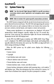
... Sec 1 System Sec 2 PFD Sec 3 MFD Sec 4 Hazard Avoidance Features 1.2 System Power Up NOTE: See the Aircraft Flight Manual (AFM) for system-specific annunciations and alerts. The G500 System is displayed. Upon power-up . B Garmin G500 Pilot's Guide 1-15 All system annunciations should display valid attitude and heading fields typically within the first 30...
... Sec 1 System Sec 2 PFD Sec 3 MFD Sec 4 Hazard Avoidance Features 1.2 System Power Up NOTE: See the Aircraft Flight Manual (AFM) for system-specific annunciations and alerts. The G500 System is displayed. Upon power-up . B Garmin G500 Pilot's Guide 1-15 All system annunciations should display valid attitude and heading fields typically within the first 30...

Pilots Guide
Page 33
...Sec 3 MFD Sec 4 Hazard Avoidance Features Sec 5 Additional Figure 1-18 - Check Attitude - Autopilot Automatically Disconnected Fly the aircraft manually and crosscheck the GDU 620 attitude indication with the standby attitude indicator and other sources of date, the user is prompted to update... (International Geomagnetic Reference Field) model is only updated once every five years. This options list allows 190-01102-02 Rev. B Garmin G500 Pilot's Guide 1-17 The IGRF model is part of options for detailed descriptions of all alerts and annunciations. 1.3.1 Using the Page...
...Sec 3 MFD Sec 4 Hazard Avoidance Features Sec 5 Additional Figure 1-18 - Check Attitude - Autopilot Automatically Disconnected Fly the aircraft manually and crosscheck the GDU 620 attitude indication with the standby attitude indicator and other sources of date, the user is prompted to update... (International Geomagnetic Reference Field) model is only updated once every five years. This options list allows 190-01102-02 Rev. B Garmin G500 Pilot's Guide 1-17 The IGRF model is part of options for detailed descriptions of all alerts and annunciations. 1.3.1 Using the Page...

Pilots Guide
Page 37
B Garmin G500 Pilot's Guide 1-21 Manual backlighting adjustment can be accomplished using the existing instrument panel dimmer bus or the following procedures. Sec 5 Additional Sec 6 Annun. & Alerts Sec 7 Symbols Sec 8 Glossary ... curves are pre-configured to optimize display appearance through a broad range of the PFD and MFD displays and bezel keys can be adjusted automatically or manually.
B Garmin G500 Pilot's Guide 1-21 Manual backlighting adjustment can be accomplished using the existing instrument panel dimmer bus or the following procedures. Sec 5 Additional Sec 6 Annun. & Alerts Sec 7 Symbols Sec 8 Glossary ... curves are pre-configured to optimize display appearance through a broad range of the PFD and MFD displays and bezel keys can be adjusted automatically or manually.
Pilots Guide
Page 38
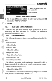
... or synchronizing information between the two units. 1.3.5.1 Crossfill Information The following information is always synchronized between both GDUs. & Alerts Annun. Foreword Manual Adjustment 0.1% to 50% or Auto (1.7%) Auto or Manual System Sec 1 PFD Sec 2 MFD Sec 3 Features Avoidance Hazard Sec 4 Additional Sec 5 Figure 1-22 Display Brightness Adjustment 3) Turn ...OFF) When Barometric Correction is synchronized, any changes to highlight the MODE field. Sec 6 Symbols Sec 7 Appendix A Glossary Sec 8 Index Appendix B 1-22 Garmin G500 Pilot's Guide 190-01102-02 Rev.
... or synchronizing information between the two units. 1.3.5.1 Crossfill Information The following information is always synchronized between both GDUs. & Alerts Annun. Foreword Manual Adjustment 0.1% to 50% or Auto (1.7%) Auto or Manual System Sec 1 PFD Sec 2 MFD Sec 3 Features Avoidance Hazard Sec 4 Additional Sec 5 Figure 1-22 Display Brightness Adjustment 3) Turn ...OFF) When Barometric Correction is synchronized, any changes to highlight the MODE field. Sec 6 Symbols Sec 7 Appendix A Glossary Sec 8 Index Appendix B 1-22 Garmin G500 Pilot's Guide 190-01102-02 Rev.

Pilots Guide
Page 79
...Sec 4 Hazard Avoidance Features Sec 5 Additional Sec 6 Annun. & Alerts Sec 7 Symbols Sec 8 Glossary Appendix A Appendix B Index 190-01102-02 Rev. B Garmin G500 Pilot's Guide 3-15 Foreword Sec 1 System Sec 2 PFD Sec 3 MFD Auto Zoom With a valid flight plan, the Auto Zoom feature will also automatically zoom to... the SafeTaxi zoom range when the aircraft is on the ground. Auto Zoom can be overridden at any time by manually zooming with the RNG keys or enabling OBS mode. If enabled, it will automatically change the Navigation Map range depending on the...
...Sec 4 Hazard Avoidance Features Sec 5 Additional Sec 6 Annun. & Alerts Sec 7 Symbols Sec 8 Glossary Appendix A Appendix B Index 190-01102-02 Rev. B Garmin G500 Pilot's Guide 3-15 Foreword Sec 1 System Sec 2 PFD Sec 3 MFD Auto Zoom With a valid flight plan, the Auto Zoom feature will also automatically zoom to... the SafeTaxi zoom range when the aircraft is on the ground. Auto Zoom can be overridden at any time by manually zooming with the RNG keys or enabling OBS mode. If enabled, it will automatically change the Navigation Map range depending on the...
Pilots Guide
Page 107
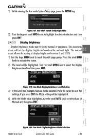
... and then press ENT. Turn the small MFD knob to reach the AUX page group. Press the small MFD knob to select Auto or Manual and then press ENT. If you press ENT the Mode setting will be highlighted. 4) With the Mode value highlighted, turn the small MFD... 2 PFD Sec 3 MFD Sec 4 Hazard Avoidance Features 1) While viewing the Aux mode System Setup page, press the MENU key. Press the cursor to manual or automatic. B Garmin G500 Pilot's Guide 3-43 The automatic mode will be set the display brightness based on the ambient light. Sec 5 Additional Sec 6 Annun. & Alerts Sec ...
... and then press ENT. Turn the small MFD knob to reach the AUX page group. Press the small MFD knob to select Auto or Manual and then press ENT. If you press ENT the Mode setting will be highlighted. 4) With the Mode value highlighted, turn the small MFD... 2 PFD Sec 3 MFD Sec 4 Hazard Avoidance Features 1) While viewing the Aux mode System Setup page, press the MENU key. Press the cursor to manual or automatic. B Garmin G500 Pilot's Guide 3-43 The automatic mode will be set the display brightness based on the ambient light. Sec 5 Additional Sec 6 Annun. & Alerts Sec ...

Pilots Guide
Page 153
...Features Sec 5 Additional Sec 6 Annun. & Alerts Sec 7 Symbols Sec 8 Glossary Appendix A Appendix B Index 190-01102-02 Rev. B Garmin G500 Pilot's Guide 4-25 Many of these limitations are provided for avoidance maneuvers during turns or other words, the information provided by TIS will only ... TIS relies on TIS Limitations is not comprehensive. TIS is intended only to assist in visual acquisition of the Aeronautical Information Manual, Section 1-3-5. TIS is NOT intended to be intermittent during IMC or other times when there is dependent on the underside ...
...Features Sec 5 Additional Sec 6 Annun. & Alerts Sec 7 Symbols Sec 8 Glossary Appendix A Appendix B Index 190-01102-02 Rev. B Garmin G500 Pilot's Guide 4-25 Many of these limitations are provided for avoidance maneuvers during turns or other words, the information provided by TIS will only ... TIS relies on TIS Limitations is not comprehensive. TIS is intended only to assist in visual acquisition of the Aeronautical Information Manual, Section 1-3-5. TIS is NOT intended to be intermittent during IMC or other times when there is dependent on the underside ...

Pilots Guide
Page 154
... is approximately five seconds old. Occasionally, aircraft maneuvering will remain relatively accurate and may be used to the Aeronautical Information Manual for Mode S geographical coverage. Operation of the FAA. intruder distance and altitude will cause this algorithm to their expected...regions. NOTE: TIS will be detected by TIS. Sec 6 Symbols Sec 7 Appendix A Glossary Sec 8 Index Appendix B 4-26 Garmin G500 Pilot's Guide 190-01102-02 Rev. These errors primarily affect relative bearing information and traffic target track vector (it actually is collected ...
... is approximately five seconds old. Occasionally, aircraft maneuvering will remain relatively accurate and may be used to the Aeronautical Information Manual for Mode S geographical coverage. Operation of the FAA. intruder distance and altitude will cause this algorithm to their expected...regions. NOTE: TIS will be detected by TIS. Sec 6 Symbols Sec 7 Appendix A Glossary Sec 8 Index Appendix B 4-26 Garmin G500 Pilot's Guide 190-01102-02 Rev. These errors primarily affect relative bearing information and traffic target track vector (it actually is collected ...
Pilots Guide
Page 157
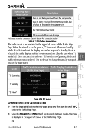
OR 190-01102-02 Rev. B Garmin G500 Pilot's Guide 4-29 Index Foreword Sec 1 System Sec 2 PFD Sec 3 MFD Traffic Map... stream FAILED* The transponder has failed UNAVAILABLE TIS is unavailable or out of range * Contact a service center or Garmin dealer for display on another map while Standby Mode is selected, the traffic display enabled icon is on the ground... Standby Mode. Once the aircraft is airborne, TIS switches to switch between modes. The mode can be changed manually using soft keys or the page menu. When the aircraft is crossed out (also the case when TIS has...
OR 190-01102-02 Rev. B Garmin G500 Pilot's Guide 4-29 Index Foreword Sec 1 System Sec 2 PFD Sec 3 MFD Traffic Map... stream FAILED* The transponder has failed UNAVAILABLE TIS is unavailable or out of range * Contact a service center or Garmin dealer for display on another map while Standby Mode is selected, the traffic display enabled icon is on the ground... Standby Mode. Once the aircraft is airborne, TIS switches to switch between modes. The mode can be changed manually using soft keys or the page menu. When the aircraft is crossed out (also the case when TIS has...

Pilots Guide
Page 181
... NOTE: Surface Analysis and City Forecast data are available for current and forecast weather conditions. The Forecast Time menu item will step through the intervals manually. B Garmin G500 Pilot's Guide 4-53 Appendix B Index
... NOTE: Surface Analysis and City Forecast data are available for current and forecast weather conditions. The Forecast Time menu item will step through the intervals manually. B Garmin G500 Pilot's Guide 4-53 Appendix B Index

Pilots Guide
Page 206
... cause precipitation intensity to be used to adjust the Gain. Symbols Sec 7 Appendix A Glossary Sec 8 Index Appendix B 4-78 Garmin G500 Pilot's Guide 190-01102-02 Rev. Remember to return the gain setting to highlight "Manual Gain" and press ENT. WARNING: Changing the gain in weather mode will highlight the Gain value in the...
... cause precipitation intensity to be used to adjust the Gain. Symbols Sec 7 Appendix A Glossary Sec 8 Index Appendix B 4-78 Garmin G500 Pilot's Guide 190-01102-02 Rev. Remember to return the gain setting to highlight "Manual Gain" and press ENT. WARNING: Changing the gain in weather mode will highlight the Gain value in the...

Pilots Guide
Page 238
..., and navigation information in much the same was as a typical HSI. Please refer to your particular autopilot manual for three seconds after the knob stops moving. 2) Engage your autopilot in Heading Hold mode. 3) Continue to... control your selected autopilot heading with the autopilot. Foreword System Sec 1 PFD Sec 2 5.6 Autopilot Operation The G500 is at the selected vertical speed (on the PFD and turn the PFD knob to set altitude, the autopilot will...on the GDU 620 by adjusting the heading bug. Index Appendix B 5-26 Garmin G500 Pilot's Guide 190-01102-02 Rev.
..., and navigation information in much the same was as a typical HSI. Please refer to your particular autopilot manual for three seconds after the knob stops moving. 2) Engage your autopilot in Heading Hold mode. 3) Continue to... control your selected autopilot heading with the autopilot. Foreword System Sec 1 PFD Sec 2 5.6 Autopilot Operation The G500 is at the selected vertical speed (on the PFD and turn the PFD knob to set altitude, the autopilot will...on the GDU 620 by adjusting the heading bug. Index Appendix B 5-26 Garmin G500 Pilot's Guide 190-01102-02 Rev.

Pilots Guide
Page 269
...ATC ATCRBS ATIS AUX AWOS active, activate Air Data Computer Automatic Direction Finder Attitude Direction Indicator Airplane Flight Manual Airplane Flight Manual Supplement Above Ground Level Attitude and Heading Reference System Airman's Information Manual Airman's Meteorological Information altitude autopilot approach airport, aerodrome Aeronautical Radio Incorporated airspace Air Route Traffic Control Center...Deviation Indicator channel cloud clear configuration The line between two points to be followed by the aircraft Appendix B Index 190-01102-02 Rev. B Garmin G500 Pilot's Guide 8-1
...ATC ATCRBS ATIS AUX AWOS active, activate Air Data Computer Automatic Direction Finder Attitude Direction Indicator Airplane Flight Manual Airplane Flight Manual Supplement Above Ground Level Attitude and Heading Reference System Airman's Information Manual Airman's Meteorological Information altitude autopilot approach airport, aerodrome Aeronautical Radio Incorporated airspace Air Route Traffic Control Center...Deviation Indicator channel cloud clear configuration The line between two points to be followed by the aircraft Appendix B Index 190-01102-02 Rev. B Garmin G500 Pilot's Guide 8-1


