Owner's Manual
Page 19
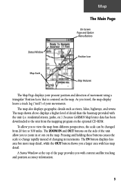
... different perspectives, the scale can be changed from 20 feet to the unit from the mapping program on the map. The map also displays geographic details such as rivers, lakes, highways, and towns. As you travel, the map display leaves a track log ("trail") of the unit allow you a larger area with current satellite tracking and... scale to zoom in increments. A Status Window at the top of changing in or out on the optional CD-ROM. residential streets, parks, etc.), because GARMIN MapSource data has been downloaded to 500 miles.
... different perspectives, the scale can be changed from 20 feet to the unit from the mapping program on the map. The map also displays geographic details such as rivers, lakes, highways, and towns. As you travel, the map display leaves a track log ("trail") of the unit allow you a larger area with current satellite tracking and... scale to zoom in increments. A Status Window at the top of changing in or out on the optional CD-ROM. residential streets, parks, etc.), because GARMIN MapSource data has been downloaded to 500 miles.
Owner's Manual
Page 20
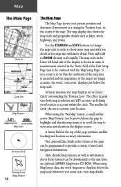
... to provide a variety of the map. Press and hold to the unit from an optional GARMIN MapSource CD-ROM. The eTrex Legend uses both map resolution and GPS accuracy in so far that the resolution of the map data is exceeded and the appearance of the map is shown in units of measurement ...at the top of the page can be programmed to a point within the circle. More detailed map features as well as lakes, rivers, highways, and towns. If you zoom in order to view map details. A Status Field at the bottom of the page provides satellite tracking and location accuracy information....
... to provide a variety of the map. Press and hold to the unit from an optional GARMIN MapSource CD-ROM. The eTrex Legend uses both map resolution and GPS accuracy in so far that the resolution of the map data is exceeded and the appearance of the map is shown in units of measurement ...at the top of the page can be programmed to a point within the circle. More detailed map features as well as lakes, rivers, highways, and towns. If you zoom in order to view map details. A Status Field at the bottom of the page provides satellite tracking and location accuracy information....
Owner's Manual
Page 22
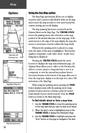
... area but redraws the map slowly. When using the panning arrow, pressing the FIND button displays items with Panning Arrow Highlighted Map Item Map Item Information 12 Using the Pan Map option The Map Page pan function allows you want to waypoints, roads, lakes, rivers...nearly everything that... item is activated from it on a map item, the name of the map display, the map also moves to reveal...
... area but redraws the map slowly. When using the panning arrow, pressing the FIND button displays items with Panning Arrow Highlighted Map Item Map Item Information 12 Using the Pan Map option The Map Page pan function allows you want to waypoints, roads, lakes, rivers...nearly everything that... item is activated from it on a map item, the name of the map display, the map also moves to reveal...


