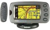

Owners Manual
Page 2
... a hard drive or other Garmin products. Garmin®, AutoLocate®, and StreetPilot® are registered trademarks of Garmin. Tel. 913/397.8200 or 800/800.1020 Fax 913/397.8282 Garmin (Europe) Ltd. Tel. 44/1794.519944 Fax 44/1794.519222 Garmin Corporation No. 68, Jangshu ...of this manual and of any unauthorized commercial distribution of Garmin. Garmin reserves the right to be reproduced, copied, transmitted, disseminated, downloaded or stored in Taiwan B Printed in any storage medium, for current updates and supplemental information concerning the use and operation of this...
... a hard drive or other Garmin products. Garmin®, AutoLocate®, and StreetPilot® are registered trademarks of Garmin. Tel. 913/397.8200 or 800/800.1020 Fax 913/397.8282 Garmin (Europe) Ltd. Tel. 44/1794.519944 Fax 44/1794.519222 Garmin Corporation No. 68, Jangshu ...of this manual and of any unauthorized commercial distribution of Garmin. Garmin reserves the right to be reproduced, copied, transmitted, disseminated, downloaded or stored in Taiwan B Printed in any storage medium, for current updates and supplemental information concerning the use and operation of this...
Owners Manual
Page 9
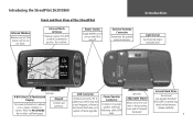
... Switch Toggle DOWN to turn unit on and UP to select a different page. Do not block. Front and Rear View of the StreetPilot Internal Patch Antenna Receives signals from remote control. Back View Adjustable Mount Allows the unit to connect to as a 'page,' 'window,'... backward. USB Connector Interface unit with a PC to update your detail map and/ or add mapping software to the internal hard drive, or to upload software upgrades. Introducing the StreetPilot 2620/2660 Infrared Window Receives signals from GPS satellites to determine position. Internal Hard Drive The internal ...
... Switch Toggle DOWN to turn unit on and UP to select a different page. Do not block. Front and Rear View of the StreetPilot Internal Patch Antenna Receives signals from remote control. Back View Adjustable Mount Allows the unit to connect to as a 'page,' 'window,'... backward. USB Connector Interface unit with a PC to update your detail map and/ or add mapping software to the internal hard drive, or to upload software upgrades. Introducing the StreetPilot 2620/2660 Infrared Window Receives signals from GPS satellites to determine position. Internal Hard Drive The internal ...

Owners Manual
Page 41
... exist that the next few blocks are unusually congested with new instructions. If this route is calculated until you stop the current navigation or until you are currently taking might want to take a detour. If you turn off the unit. Note that will not...to the original route. however, the distance may be the only reasonable option. The StreetPilot will calculate a new route and provide you with traffic, you select a distance, your StreetPilot will recalculate and update your current route. Also, your current route. Reference Creating Routes Select a distance from...
... exist that the next few blocks are unusually congested with new instructions. If this route is calculated until you stop the current navigation or until you are currently taking might want to take a detour. If you turn off the unit. Note that will not...to the original route. however, the distance may be the only reasonable option. The StreetPilot will calculate a new route and provide you with traffic, you select a distance, your StreetPilot will recalculate and update your current route. Also, your current route. Reference Creating Routes Select a distance from...
Owners Manual
Page 62
...if you plan to use a serial port connection, change the settings below : • Garmin: The proprietary format used only by authorized Garmin installers who must be used at once. If you are using the Garmin USB cable to transfer data, keep USB Format set to transfer data via serial connection. ...from the Interface tab. Most of USB. Note: Only the USB or the serial cable can customize the bottom-row settings on the StreetPilot 2660 with data for software updates and to save mapping software to use both at one of the available settings below as necessary: USB Format -
...if you plan to use a serial port connection, change the settings below : • Garmin: The proprietary format used only by authorized Garmin installers who must be used at once. If you are using the Garmin USB cable to transfer data, keep USB Format set to transfer data via serial connection. ...from the Interface tab. Most of USB. Note: Only the USB or the serial cable can customize the bottom-row settings on the StreetPilot 2660 with data for software updates and to save mapping software to use both at one of the available settings below as necessary: USB Format -
Owners Manual
Page 63
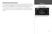
... key; Always check to make sure the version you wish to download is currently loaded in the StreetPilot. a Menu page will appear. Software updates for registration and identification purposes. Obtaining the latest Software Upgrades The System Info page displays the software version...also shows the StreetPilot's unit ID number, which is used for your StreetPilot's current software version as well as the unit's identification number on the System Info page. 55 Reference Software Updates View your StreetPilot can be found periodically at our Web site at www.garmin.com. From ...
... key; Always check to make sure the version you wish to download is currently loaded in the StreetPilot. a Menu page will appear. Software updates for registration and identification purposes. Obtaining the latest Software Upgrades The System Info page displays the software version...also shows the StreetPilot's unit ID number, which is used for your StreetPilot's current software version as well as the unit's identification number on the System Info page. 55 Reference Software Updates View your StreetPilot can be found periodically at our Web site at www.garmin.com. From ...

Owners Manual
Page 65
...sky view is not highlighted. • Hollow signal strength bar: The GPS receiver has found the satellite and is being used for use the sky view to your StreetPilot is ready for navigation (solid green signal strength bar). Sky View Satellites Signal strength bars A...green signal strength bar: The GPS receiver has collected the necessary data and the satellite(s) is looking for the satellite(s) indicated. Once a fix has been calculated, the StreetPilot then updates your position, ground track, and ground speed by 2D Navigation or 3D Navigation in your unit's last known ...
...sky view is not highlighted. • Hollow signal strength bar: The GPS receiver has found the satellite and is being used for use the sky view to your StreetPilot is ready for navigation (solid green signal strength bar). Sky View Satellites Signal strength bars A...green signal strength bar: The GPS receiver has collected the necessary data and the satellite(s) is looking for the satellite(s) indicated. Once a fix has been calculated, the StreetPilot then updates your position, ground track, and ground speed by 2D Navigation or 3D Navigation in your unit's last known ...

Owners Manual
Page 67
...indicates the accuracy of the position fix. It is incorrect, the StreetPilot does not know the current positions of the GPS satellites. A variety of options can be performed via the Menu page shown above. update your unit's MENU key while you first use if the ... traveled over 500 miles with the GPS Information page displayed). Updating your StreetPilot. The prompt may be looking for the wrong group of satellites. GPS Information Page Options To display the GPS Information page options, press MENU (with the unit turned off the GPS for using the unit indoors for ...
...indicates the accuracy of the position fix. It is incorrect, the StreetPilot does not know the current positions of the GPS satellites. A variety of options can be performed via the Menu page shown above. update your unit's MENU key while you first use if the ... traveled over 500 miles with the GPS Information page displayed). Updating your StreetPilot. The prompt may be looking for the wrong group of satellites. GPS Information Page Options To display the GPS Information page options, press MENU (with the unit turned off the GPS for using the unit indoors for ...
Owners Manual
Page 78
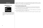
...page 55) and serial # (see page i). 70 In order to enable additional maps, you want the StreetPilot to use for the search, and it will return a list of cities or places only from this ...worry about accidentally deleting them. Your pre-programmed hard drive contains approximately 512 MB of your StreetPilot If information for your pre-programmed hard drive. Reference Adding Maps to your installed maps that ...Map page. Your pre-installed detail maps are protected from Garmin and download the maps to your additional maps. If this map family. This amount may be reduced as ...
...page 55) and serial # (see page i). 70 In order to enable additional maps, you want the StreetPilot to use for the search, and it will return a list of cities or places only from this ...worry about accidentally deleting them. Your pre-programmed hard drive contains approximately 512 MB of your StreetPilot If information for your pre-programmed hard drive. Reference Adding Maps to your installed maps that ...Map page. Your pre-installed detail maps are protected from Garmin and download the maps to your additional maps. If this map family. This amount may be reduced as ...
Owners Manual
Page 81
...x 2.0"D (14.3 x 8.0 x 5.0 cm) Weight: .93 pounds (420 g) Display: 3.3"W x 1.7"H (8.4 x 4.4 cm), (305 x 160 pixels), automotive-grade 8-bit, 256-color LCD with polarized sunglasses Case: Rugged; MCX-type connector for automatic backlight dimming Data Storage: Indefinite; Range: 32° ...: 12 parallel channel receiver Acquisition Times* Warm: Approximately 15 seconds Cold: Approximately 45 seconds AutoLocate: Approximately 2 minutes Update Rate: Once per second, continuous GPS Accuracy Position**: compatible with automatic dimming backlight and touchscreen;
...x 2.0"D (14.3 x 8.0 x 5.0 cm) Weight: .93 pounds (420 g) Display: 3.3"W x 1.7"H (8.4 x 4.4 cm), (305 x 160 pixels), automotive-grade 8-bit, 256-color LCD with polarized sunglasses Case: Rugged; MCX-type connector for automatic backlight dimming Data Storage: Indefinite; Range: 32° ...: 12 parallel channel receiver Acquisition Times* Warm: Approximately 15 seconds Cold: Approximately 45 seconds AutoLocate: Approximately 2 minutes Update Rate: Once per second, continuous GPS Accuracy Position**: compatible with automatic dimming backlight and touchscreen;

Owners Manual
Page 93
Garmin (Europe) Ltd. Unit 5, The Quadrangle, Abbey Park Industrial Estate, Romsey, SO51 9DL, U.K. Garmin Corporation No. 68, Jangshu 2nd Road, Shijr, Taipei County, Taiwan www.garmin.com Part Number 190-00342-00 Rev. Copyright 2004, 2005 Garmin Ltd. B or its subsidiaries Garmin International, Inc. 1200 East 151st Street, Olathe, Kansas 66062, U.S.A. For the latest free software updates (excluding map data) throughout the life of your Garmin products, visit the Garmin Web site at www.garmin.com.
Garmin (Europe) Ltd. Unit 5, The Quadrangle, Abbey Park Industrial Estate, Romsey, SO51 9DL, U.K. Garmin Corporation No. 68, Jangshu 2nd Road, Shijr, Taipei County, Taiwan www.garmin.com Part Number 190-00342-00 Rev. Copyright 2004, 2005 Garmin Ltd. B or its subsidiaries Garmin International, Inc. 1200 East 151st Street, Olathe, Kansas 66062, U.S.A. For the latest free software updates (excluding map data) throughout the life of your Garmin products, visit the Garmin Web site at www.garmin.com.


