Owners Manual
Page 3
... our online registration today! Unit operation and specifications are just moving around the Map page for repairs. To get the most out of the most advanced GPS navigation systems available! Lastly, learn the basics, read the sections on customizing your StreetPilot to change or modify the unit in a safe place or attach a photocopy inside the manual. Serial Number: I The Garmin StreetPilot 2620/2660 has no user-serviceable parts. Any...
... our online registration today! Unit operation and specifications are just moving around the Map page for repairs. To get the most out of the most advanced GPS navigation systems available! Lastly, learn the basics, read the sections on customizing your StreetPilot to change or modify the unit in a safe place or attach a photocopy inside the manual. Serial Number: I The Garmin StreetPilot 2620/2660 has no user-serviceable parts. Any...
Owners Manual
Page 5
... OWN ROUTES 28 Creating your First Route 29 Setting a HOME Waypoint 30 Saving a Route 32 Deleting or Renaming a Saved Route 32 Modifying a Route 33 Measuring Distances Between Two Places ...........36 CUSTOMIZING YOUR STREETPILOT 2620/2660 .......38 Adjusting the Backlight and Contrast 38 Turning off Satellite Reception for Indoor Use .....38 Customizing your Map Page 39 Hiding/Showing Data Tabs on your Map Page .....41 Customizing the Overall Setup of Your StreetPilot44 Obtaining the latest Software Upgrades...
... OWN ROUTES 28 Creating your First Route 29 Setting a HOME Waypoint 30 Saving a Route 32 Deleting or Renaming a Saved Route 32 Modifying a Route 33 Measuring Distances Between Two Places ...........36 CUSTOMIZING YOUR STREETPILOT 2620/2660 .......38 Adjusting the Backlight and Contrast 38 Turning off Satellite Reception for Indoor Use .....38 Customizing your Map Page 39 Hiding/Showing Data Tabs on your Map Page .....41 Customizing the Overall Setup of Your StreetPilot44 Obtaining the latest Software Upgrades...
Owners Manual
Page 6
... GPS navigation beginning on page 56. •To find a city, address, intersection, park, or other point of interest, see Finding Places, beginning on page 6. Step 1: If you do not want your vehicle's cigarette lighter. When your StreetPilot has established a satellite fix, your screen should display a "Ready to Navigate" message, as shown Note: Make certain your StreetPilot's view is unobstructed as the remote ROUTE...
... GPS navigation beginning on page 56. •To find a city, address, intersection, park, or other point of interest, see Finding Places, beginning on page 6. Step 1: If you do not want your vehicle's cigarette lighter. When your StreetPilot has established a satellite fix, your screen should display a "Ready to Navigate" message, as shown Note: Make certain your StreetPilot's view is unobstructed as the remote ROUTE...
Owners Manual
Page 8
... services provided by practicing creating routes in simulator mode. GPS will be turned off to allow a passenger to operate the unit. See page 4 to learn how to use the remote control, most instruc- When your accuracy when activating commands. Or, press in this manual assume that is enabled, but it can either touch the screen to activate commands or use it. tions in on your remote control. OPERATE YOUR STREETPILOT IN "SAFE MODE...
... services provided by practicing creating routes in simulator mode. GPS will be turned off to allow a passenger to operate the unit. See page 4 to learn how to use the remote control, most instruc- When your accuracy when activating commands. Or, press in this manual assume that is enabled, but it can either touch the screen to activate commands or use it. tions in on your remote control. OPERATE YOUR STREETPILOT IN "SAFE MODE...

Owners Manual
Page 13
... unit will appear after the last letter option has been shown. slider thumb speaker volume slider 5 • ROUTE Key- For letters, press the appropriate number key as many times as an alternative to using it controls movement of available route navigation features. • THUMB STICK - Replace the cover. Press and hold the SPEAK/VOLUME key. All the way down turns off , user setting, and maximum volume...
... unit will appear after the last letter option has been shown. slider thumb speaker volume slider 5 • ROUTE Key- For letters, press the appropriate number key as many times as an alternative to using it controls movement of available route navigation features. • THUMB STICK - Replace the cover. Press and hold the SPEAK/VOLUME key. All the way down turns off , user setting, and maximum volume...
Owners Manual
Page 14
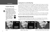
..., depending on your StreetPilot's main operating page. You can quickly understand what 's ahead on your current driving mode, tabs that you are ready to navigate. Many features make up the Map page. Reference Using the Map Page USING YOUR STREETPILOT INDOORS F Your StreetPilot unit cannot acquire satellites from the road while driving. You will provide such information as surrounding street detail. Touch the screen anywhere with your StreetPilot locates the satellites, it around the...
..., depending on your StreetPilot's main operating page. You can quickly understand what 's ahead on your current driving mode, tabs that you are ready to navigate. Many features make up the Map page. Reference Using the Map Page USING YOUR STREETPILOT INDOORS F Your StreetPilot unit cannot acquire satellites from the road while driving. You will provide such information as surrounding street detail. Touch the screen anywhere with your StreetPilot locates the satellites, it around the...

Owners Manual
Page 20
... StreetPilot turned on but you are not navigating a route, and a Map page in "driving" mode, which appears when you have traveled, distance to your destination Your Current Position Time until your next turn , and more information. Map Orientation Your current speed Route Line Distance until your current location, and it . able data tabs are pre-set to display information such as the direction in which appears when you have created a route and are pre-set...
... StreetPilot turned on but you are not navigating a route, and a Map page in "driving" mode, which appears when you have traveled, distance to your destination Your Current Position Time until your next turn , and more information. Map Orientation Your current speed Route Line Distance until your current location, and it . able data tabs are pre-set to display information such as the direction in which appears when you have created a route and are pre-set...
Owners Manual
Page 22
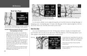
... to that turn . If you need to worry about navigation instructions for quite a while. · As you reach the upcoming turn , the Next Turn page appears again. When this feature whether you are driving during an active route, the Map page continues to display in routing mode until you are near a turn . Reference Next Turn Page Your StreetPilot safely navigates you to change lanes if necessary and start looking for...
... to that turn . If you need to worry about navigation instructions for quite a while. · As you reach the upcoming turn , the Next Turn page appears again. When this feature whether you are driving during an active route, the Map page continues to display in routing mode until you are near a turn . Reference Next Turn Page Your StreetPilot safely navigates you to change lanes if necessary and start looking for...
Owners Manual
Page 29
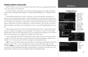
... state/province in which you are currently physically located, or where the map pointer is located if you are trying to box and select one entry appears after the list is refined. 21 Try to narrow your search as much as possible to enter data. When you enter street names, do not enter directional words such as "West" or types of the Address...
... state/province in which you are currently physically located, or where the map pointer is located if you are trying to box and select one entry appears after the list is refined. 21 Try to narrow your search as much as possible to enter data. When you enter street names, do not enter directional words such as "West" or types of the Address...

Owners Manual
Page 33
..., displaying the longitude and latitude coordinates of view shown above , you can then take straight-line measurements from the new location to your current location or other location. See Measuring Distances Between Two Places, page 36, for more information on the Map page when you select a location through the Find feature, select Show Map to display this measuring tool, press the unit's MENU key and then select the Measure Distance icon. The...
..., displaying the longitude and latitude coordinates of view shown above , you can then take straight-line measurements from the new location to your current location or other location. See Measuring Distances Between Two Places, page 36, for more information on the Map page when you select a location through the Find feature, select Show Map to display this measuring tool, press the unit's MENU key and then select the Measure Distance icon. The...

Owners Manual
Page 36
... for directions or consult a map. Recalculates the active route for creating routes. A list of the current route. Consider creating and running routes in this page for the first time or if you create a route and activate it and you to a final destination. The options below are navigating or simulating a route. 28 Creating your own Routes Use the ROUTE feature on the unit and selecting the 'Use Indoors' icon. This option is available only when you will turn off GPS...
... for directions or consult a map. Recalculates the active route for creating routes. A list of the current route. Consider creating and running routes in this page for the first time or if you create a route and activate it and you to a final destination. The options below are navigating or simulating a route. 28 Creating your own Routes Use the ROUTE feature on the unit and selecting the 'Use Indoors' icon. This option is available only when you will turn off GPS...

Owners Manual
Page 37
... your First Route Creating routes are at work, home, at right. Use Map - Choose this option if you to create and activate an entirely new route. Creating your current physical location (you are fast and easy once you three options for creating routes as quickly and as easily as shown above will appear. Once you activated. A voice prompt sounds and a magenta route line appears. A 'Start Point' window appears. 2. Select the appropriate option. 4. A thumbnail route map appears...
... your First Route Creating routes are at work, home, at right. Use Map - Choose this option if you to create and activate an entirely new route. Creating your current physical location (you are fast and easy once you three options for creating routes as quickly and as easily as shown above will appear. Once you activated. A voice prompt sounds and a magenta route line appears. A 'Start Point' window appears. 2. Select the appropriate option. 4. A thumbnail route map appears...

Owners Manual
Page 40
.... Select Delete to your previous route on the next route in your Route List. Select Activate to leave. When the Route List page appears, press the MENU key from your View your saved routes will appear. To select a route from a list of saved routes by touching the route's current name. Information about that will appear. Select Rename to delete all of your list of saved routes, select Route List from the Route Menu. In either during the navigation or after the route is complete. A new page...
.... Select Delete to your previous route on the next route in your Route List. Select Activate to leave. When the Route List page appears, press the MENU key from your View your saved routes will appear. To select a route from a list of saved routes by touching the route's current name. Information about that will appear. Select Rename to delete all of your list of saved routes, select Route List from the Route Menu. In either during the navigation or after the route is complete. A new page...

Owners Manual
Page 51
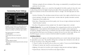
... Routing data tabs: Address - Satellite Status - To show /hide one or all data tabs: From the Map page, press MENU on the right side of navigational data as 'Mapping' in reverse to hide it is replaced by -second location readings, since the Trip Computer was last reset. Reference Hiding/Showing Data Tabs RESTORING ORIGINAL TAB SETTINGS The Wide Tabs setting for both tabs. The tab is selected. Indicates your current location. Time...
... Routing data tabs: Address - Satellite Status - To show /hide one or all data tabs: From the Map page, press MENU on the right side of navigational data as 'Mapping' in reverse to hide it is replaced by -second location readings, since the Trip Computer was last reset. Reference Hiding/Showing Data Tabs RESTORING ORIGINAL TAB SETTINGS The Wide Tabs setting for both tabs. The tab is selected. Indicates your current location. Time...

Owners Manual
Page 53
... your Units setting (see page 43). By selecting SPEAK Key Only, the unit only talks when the SPEAK key is shown in kilometers per hour and elevation is pressed. 45 General tab Color Scheme - Time Format, Time Zone, Daylight Savings, Time, Date, Sunrise, Sunset Safety - Units - Metric shows speed in feet. Off-Route Recalculation, Next Turn Pop-Up Routing - Switches 'Safe Mode' On and Off Track Log - USB Format, Serial Format...
... your Units setting (see page 43). By selecting SPEAK Key Only, the unit only talks when the SPEAK key is shown in kilometers per hour and elevation is pressed. 45 General tab Color Scheme - Time Format, Time Zone, Daylight Savings, Time, Date, Sunrise, Sunset Safety - Units - Metric shows speed in feet. Off-Route Recalculation, Next Turn Pop-Up Routing - Switches 'Safe Mode' On and Off Track Log - USB Format, Serial Format...
Owners Manual
Page 56
... calculate. The StreetPilot will use these road types only if alternative routes take full advantage of your routes. Allows you too far out of the routing information built into the StreetPilot's mapping software. Avoidance button The Avoidance button appears on your vehicle type. Calculate Routes for your type of that may not allow commercial trucking traffic. This setting is available. • U-Turns: If checked, the StreetPilot does not direct you optimize...
... calculate. The StreetPilot will use these road types only if alternative routes take full advantage of your routes. Allows you too far out of the routing information built into the StreetPilot's mapping software. Avoidance button The Avoidance button appears on your vehicle type. Calculate Routes for your type of that may not allow commercial trucking traffic. This setting is available. • U-Turns: If checked, the StreetPilot does not direct you optimize...
Owners Manual
Page 62
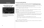
... using the Garmin USB cable to transfer data, keep USB Format set to exchange waypoint, route, track log data with a PC via a USB connection. If necessary, you plan to use a serial port connection, change the settings below : • Garmin: The proprietary format used at once. Serial Format - If you can customize the bottom-row settings on the StreetPilot 2660 with data for the StreetPilot 2660. Thus, either USB Format or Serial Format must install the Dead Reckoning (DR) cable for software updates and to save mapping software...
... using the Garmin USB cable to transfer data, keep USB Format set to exchange waypoint, route, track log data with a PC via a USB connection. If necessary, you plan to use a serial port connection, change the settings below : • Garmin: The proprietary format used at once. Serial Format - If you can customize the bottom-row settings on the StreetPilot 2660 with data for the StreetPilot 2660. Thus, either USB Format or Serial Format must install the Dead Reckoning (DR) cable for software updates and to save mapping software...

Owners Manual
Page 67
... which aligns the Map page to determine its position. See Appendix F for a few satellites are available: Track Up/North Up, New Elevation, New Location, and Enable WAAS. Changes the sky view display from where the StreetPilot was last used. This option can : turn off . New Location - It is incorrect, the StreetPilot does not know the current positions of options can also touch the sky view on the GPS Information page. 59...
... which aligns the Map page to determine its position. See Appendix F for a few satellites are available: Track Up/North Up, New Elevation, New Location, and Enable WAAS. Changes the sky view display from where the StreetPilot was last used. This option can : turn off . New Location - It is incorrect, the StreetPilot does not know the current positions of options can also touch the sky view on the GPS Information page. 59...
Owners Manual
Page 79
... Map Storage Error: File not Found - The unit's memory is Full - Reference Appendix E: Messages 71 Check antenna connections or try moving it was too long. Route Data Transfer Complete - If the problem persists, return the unit to unit operating characteristics. Map Storage Error: Bad Format - Lost Satellite Reception - The unit has lost satellite signals. Messages The StreetPilot 2620/2660 uses an on the internal disk drive do not support automatic route calculation. Unrecognized data format. GPS Turned Off for repair. Return for Indoor Use - Map Storage...
... Map Storage Error: File not Found - The unit's memory is Full - Reference Appendix E: Messages 71 Check antenna connections or try moving it was too long. Route Data Transfer Complete - If the problem persists, return the unit to unit operating characteristics. Map Storage Error: Bad Format - Lost Satellite Reception - The unit has lost satellite signals. Messages The StreetPilot 2620/2660 uses an on the internal disk drive do not support automatic route calculation. Unrecognized data format. GPS Turned Off for repair. Return for Indoor Use - Map Storage...

Owners Manual
Page 80
... Mode display. The unit has no more space for map-based route waypoints (used all available waypoints. Track Memory is Full - Appendix Messages Route Waypoint Memory is Full - Waypoint Name Already Used: - Track Data Transfer Complete - Track log memory is switching to create memory space. The map is full. Delete unwanted waypoints to make space for turns). The oldest track log points were deleted to make space for the most recent data. The waypoint name you have used for new...
... Mode display. The unit has no more space for map-based route waypoints (used all available waypoints. Track Memory is Full - Appendix Messages Route Waypoint Memory is Full - Waypoint Name Already Used: - Track Data Transfer Complete - Track log memory is switching to create memory space. The map is full. Delete unwanted waypoints to make space for turns). The oldest track log points were deleted to make space for the most recent data. The waypoint name you have used for new...


