Owners Manual
Page 3
... the equipment. Also, be sure to record your StreetPilot 2620/2660 handy and connect to create an unsurpassed mobile navigation system. The StreetPilot 2620/2660 is arranged to teach you how to an authorized Garmin dealer for a quick reference. To get the most advanced GPS navigation systems available! Preface Congratulations on the Home page. This manual covers instructions...
... the equipment. Also, be sure to record your StreetPilot 2620/2660 handy and connect to create an unsurpassed mobile navigation system. The StreetPilot 2620/2660 is arranged to teach you how to an authorized Garmin dealer for a quick reference. To get the most advanced GPS navigation systems available! Preface Congratulations on the Home page. This manual covers instructions...
Owners Manual
Page 4
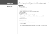
... Package: • StreetPilot 2620 or 2660 • Dash Mount • Portable Bean Bag Mount (Friction Mount) • External Speaker with your unit, please check to see that your package includes the following items. If any parts are missing, please contact your Garmin dealer immediately. not ... • Quick Reference Guide Optional Accessories: • Remote GPS Antenna (GA 27C) and antenna mounts • Deluxe Carrying Case View our Web site at www.garmin.com for a complete list of StreetPilot 2620/2660 accessories. Introduction Packing List ii Before installing and getting started...
... Package: • StreetPilot 2620 or 2660 • Dash Mount • Portable Bean Bag Mount (Friction Mount) • External Speaker with your unit, please check to see that your package includes the following items. If any parts are missing, please contact your Garmin dealer immediately. not ... • Quick Reference Guide Optional Accessories: • Remote GPS Antenna (GA 27C) and antenna mounts • Deluxe Carrying Case View our Web site at www.garmin.com for a complete list of StreetPilot 2620/2660 accessories. Introduction Packing List ii Before installing and getting started...
Owners Manual
Page 5
... TUTORIAL iv Manual Conventions vi INTRODUCING THE STREETPILOT 2620/2660 1 Front and Rear View of the StreetPilot 1 Caring for your StreetPilot 2 Turning the StreetPilot On and Off 3 Using the Keypad 3...Modifying a Route 33 Measuring Distances Between Two Places ...........36 CUSTOMIZING YOUR STREETPILOT 2620/2660 .......38 Adjusting the Backlight and Contrast 38 Turning off Satellite Reception ...ONLY) ........65 APPENDIX C: USING DIACRITICAL MARKS 66 APPENDIX D: ADDING MAPS TO YOUR STREETPILOT .68 APPENDIX E: MESSAGES 71 APPENDIX F: SPECIFICATIONS 73 APPENDIX G: SAFETY AND REGULATORY ...
... TUTORIAL iv Manual Conventions vi INTRODUCING THE STREETPILOT 2620/2660 1 Front and Rear View of the StreetPilot 1 Caring for your StreetPilot 2 Turning the StreetPilot On and Off 3 Using the Keypad 3...Modifying a Route 33 Measuring Distances Between Two Places ...........36 CUSTOMIZING YOUR STREETPILOT 2620/2660 .......38 Adjusting the Backlight and Contrast 38 Turning off Satellite Reception ...ONLY) ........65 APPENDIX C: USING DIACRITICAL MARKS 66 APPENDIX D: ADDING MAPS TO YOUR STREETPILOT .68 APPENDIX E: MESSAGES 71 APPENDIX F: SPECIFICATIONS 73 APPENDIX G: SAFETY AND REGULATORY ...
Owners Manual
Page 6
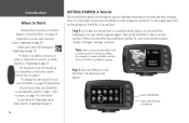
...about the Map page and its many features, beginning on page 6. If you do not want your StreetPilot to automatically switch to "night" colors at sunset, see page 39 (color mode). •Learn about GPS navigation beginning on page 56. •To find a city, address, intersection, park, or ...press the FIND key then, touch the Food & Drink icon iv GETTING STARTED: A Tutorial The tutorial below guides you have never used a StreetPilot or a GPS navigation unit before, try this simple task. Introduction Where to find it •To learn how to use the keypad on ZOOM QUIT PAGE...
...about the Map page and its many features, beginning on page 6. If you do not want your StreetPilot to automatically switch to "night" colors at sunset, see page 39 (color mode). •Learn about GPS navigation beginning on page 56. •To find a city, address, intersection, park, or ...press the FIND key then, touch the Food & Drink icon iv GETTING STARTED: A Tutorial The tutorial below guides you have never used a StreetPilot or a GPS navigation unit before, try this simple task. Introduction Where to find it •To learn how to use the keypad on ZOOM QUIT PAGE...
Owners Manual
Page 8
...the remote control unit to use it can either touch the screen to the StreetPilot as a "StreetPilot," "unit," or "GPS receiver." It makes no distinction between these terms. "StreetPilot" refers to both the 2620 and 2660 models unless specifically stated. • This manual uses... STREETPILOT IN SIMULATOR MODE Thoroughly familiarize yourself with the routing features of the StreetPilot by our new product registration system are now being automated and re-registering your purchase ensures you the best possible support from Garmin. Simulator mode only works when the GPS navigation ...
...the remote control unit to use it can either touch the screen to the StreetPilot as a "StreetPilot," "unit," or "GPS receiver." It makes no distinction between these terms. "StreetPilot" refers to both the 2620 and 2660 models unless specifically stated. • This manual uses... STREETPILOT IN SIMULATOR MODE Thoroughly familiarize yourself with the routing features of the StreetPilot by our new product registration system are now being automated and re-registering your purchase ensures you the best possible support from Garmin. Simulator mode only works when the GPS navigation ...
Owners Manual
Page 9
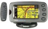
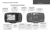
... On-screen information is referred to turn off. Introduction Light Sensor Automatically adjusts backlight level. Introducing the StreetPilot 2620/2660 Infrared Window Receives signals from GPS satellites to determine position. Front and Rear View of the StreetPilot Internal Patch Antenna Receives signals from remote control. USB Connector Interface unit with a PC to update your...
... On-screen information is referred to turn off. Introduction Light Sensor Automatically adjusts backlight level. Introducing the StreetPilot 2620/2660 Infrared Window Receives signals from GPS satellites to determine position. Front and Rear View of the StreetPilot Internal Patch Antenna Receives signals from remote control. USB Connector Interface unit with a PC to update your...
Owners Manual
Page 26
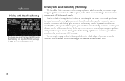
... continue to get navigation guidance even if you lose GPS reception, such as when you are driving. In this way, it must be professionally installed by an authorized Garmin installer). Driving with dead reckoning capabilities is so seamless, you will navigate the same way ...that your GPS reception returns. Thus, when you lose GPS reception, your StreetPilot can continue to accurately give navigation guidance until your StreetPilot is using Dead Reckoning is connected to your vehicle's speedometer and backup lights (it can acknowledge your turns as well as the StreetPilot 2620. 18...
... continue to get navigation guidance even if you lose GPS reception, such as when you are driving. In this way, it must be professionally installed by an authorized Garmin installer). Driving with dead reckoning capabilities is so seamless, you will navigate the same way ...that your GPS reception returns. Thus, when you lose GPS reception, your StreetPilot can continue to accurately give navigation guidance until your StreetPilot is using Dead Reckoning is connected to your vehicle's speedometer and backup lights (it can acknowledge your turns as well as the StreetPilot 2620. 18...

Owners Manual
Page 36
Consider creating and running routes in this menu, you will turn off GPS capability and allow you are available, although all vias. Set your StreetPilot to a final destination. The Route Menu lists many options for two seconds. This option is available only when you initiated the ...or anywhere! To further ensure safety, consider creating and saving routes before you are viewing an active (or simulated) route. When you are navigating or simulating a route. 28 Creating your own Routes Use the ROUTE feature on the MENU/ROUTE key from which you are viewing an active...
Consider creating and running routes in this menu, you will turn off GPS capability and allow you are available, although all vias. Set your StreetPilot to a final destination. The Route Menu lists many options for two seconds. This option is available only when you initiated the ...or anywhere! To further ensure safety, consider creating and saving routes before you are viewing an active (or simulated) route. When you are navigating or simulating a route. 28 Creating your own Routes Use the ROUTE feature on the MENU/ROUTE key from which you are viewing an active...

Owners Manual
Page 51
...' or 'Show Tabs' (depending on the right side of navigational data as 'Mapping' in reverse to view the original tab settings, select Wide Tabs for the next turn when navigating a route. Shows GPS status when stationary, the next intersection when driving, and driving ...instructions for both the Mapping and Routing tabs contain the original tab settings. Estimated time of arrival at your StreetPilot's current position fix with GPS satellites. Next ...
...' or 'Show Tabs' (depending on the right side of navigational data as 'Mapping' in reverse to view the original tab settings, select Wide Tabs for the next turn when navigating a route. Shows GPS status when stationary, the next intersection when driving, and driving ...instructions for both the Mapping and Routing tabs contain the original tab settings. Estimated time of arrival at your StreetPilot's current position fix with GPS satellites. Next ...

Owners Manual
Page 64
..., including current satellite coverage, receiver status, and position accuracy. A GPS receiver must be locked on the StreetPilot's Map page. Touch the GPS Info icon and the GPS Information page will appear. Note how the StreetPilot has not yet found the satellite(s) and is a satellite-based navigation system made the system available for use. 56 Understanding the...
..., including current satellite coverage, receiver status, and position accuracy. A GPS receiver must be locked on the StreetPilot's Map page. Touch the GPS Info icon and the GPS Information page will appear. Note how the StreetPilot has not yet found the satellite(s) and is a satellite-based navigation system made the system available for use. 56 Understanding the...

Owners Manual
Page 65
... bars A signal strength bar appears for each satellite in view. Once a fix has been calculated, the StreetPilot then updates your StreetPilot is directly overhead. The progress of 45° above ) before that satellite can use . The inner circle ...represents an elevation of satellite acquisition is shown in three stages: • No signal strength bar: The GPS receiver in your position, ground track, and ground speed by 2D Navigation or 3D Navigation...
... bars A signal strength bar appears for each satellite in view. Once a fix has been calculated, the StreetPilot then updates your StreetPilot is directly overhead. The progress of 45° above ) before that satellite can use . The inner circle ...represents an elevation of satellite acquisition is shown in three stages: • No signal strength bar: The GPS receiver in your position, ground track, and ground speed by 2D Navigation or 3D Navigation...

Owners Manual
Page 66
... been locked onto; Acquiring Sats - your current location and date on the satellite sky view are for navigation. The status is insufficient. Poor GPS Coverage - GPS is initializing and collecting new almanac data. The StreetPilot is below the horizon). a two-dimensional position fix (latitude and longitude) is being used indoors and cannot...
... been locked onto; Acquiring Sats - your current location and date on the satellite sky view are for navigation. The status is insufficient. Poor GPS Coverage - GPS is initializing and collecting new almanac data. The StreetPilot is below the horizon). a two-dimensional position fix (latitude and longitude) is being used indoors and cannot...

Owners Manual
Page 67
...you first use if the antenna is shaded or when the unit is incorrect, the StreetPilot does not know the current positions of the GPS satellites. Reference GPS Info Page The 'Poor Satellite Reception' menu gives you have the unit automatically search for ...WAAS. or have traveled over 500 miles with the GPS Information page displayed). In such instances, without initialization, the StreetPilot may also appear during normal use your approximate location ensures that the StreetPilot is searching for the StreetPilot's performance specifications which aligns the Map page...
...you first use if the antenna is shaded or when the unit is incorrect, the StreetPilot does not know the current positions of the GPS satellites. Reference GPS Info Page The 'Poor Satellite Reception' menu gives you have the unit automatically search for ...WAAS. or have traveled over 500 miles with the GPS Information page displayed). In such instances, without initialization, the StreetPilot may also appear during normal use your approximate location ensures that the StreetPilot is searching for the StreetPilot's performance specifications which aligns the Map page...

Owners Manual
Page 68
... WAAS satellites. View the GPS Information page to designate your approximate elevation when the StreetPilot is acquiring satellites or navigating within a two-dimensional position. Reference GPS Info Page A 'D' on various signal strength bars above indicate which GPS satellites are being differentially corrected...too short, the 'D' will appear above the bar, as a Garmin GA 27C. For 'Use Map,' a 'New Location' map page appears. 3. Enable WAAS - GPS satellites can be unavailable even though normal GPS reception remains unaffected and fully operational. If the elevation shown is...
... WAAS satellites. View the GPS Information page to designate your approximate elevation when the StreetPilot is acquiring satellites or navigating within a two-dimensional position. Reference GPS Info Page A 'D' on various signal strength bars above indicate which GPS satellites are being differentially corrected...too short, the 'D' will appear above the bar, as a Garmin GA 27C. For 'Use Map,' a 'New Location' map page appears. 3. Enable WAAS - GPS satellites can be unavailable even though normal GPS reception remains unaffected and fully operational. If the elevation shown is...
Owners Manual
Page 69
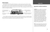
... destination. Refer to impact it in an accident or collision. Note: An optional external remote antenna (Garmin GA 27C) may be certain to select a location where the StreetPilot's antenna has a relatively unobstructed view of the sky. Also included is a non-skid friction mount ...driver or passengers, causing possible injury. The mounting hardware provided by Garmin is designed for convenient temporary mounting for installation that can block the GPS signals. 61 Vehicle Installation The StreetPilot 2620/2660 is portable, allowing you to easily carry the unit from vehicle to vehicle or...
... destination. Refer to impact it in an accident or collision. Note: An optional external remote antenna (Garmin GA 27C) may be certain to select a location where the StreetPilot's antenna has a relatively unobstructed view of the sky. Also included is a non-skid friction mount ...driver or passengers, causing possible injury. The mounting hardware provided by Garmin is designed for convenient temporary mounting for installation that can block the GPS signals. 61 Vehicle Installation The StreetPilot 2620/2660 is portable, allowing you to easily carry the unit from vehicle to vehicle or...
Owners Manual
Page 79
...A waypoint or route failed to the unit. If the problem persists, return the unit to Garmin for repair. Return for indoor use. Not all maps on the internal disk drive do not... route calculation. Maps that are turns missing prior to the unit from another GPS unit or a PC). GPS satellite reception has been disabled for repair. The unit has lost satellite signals....- Lost Satellite Reception - Map Storage Error: File not Found - Messages The StreetPilot 2620/2660 uses an on the touchscreen. Return for Indoor Use - The route has been truncated because it to ...
...A waypoint or route failed to the unit. If the problem persists, return the unit to Garmin for repair. Return for indoor use. Not all maps on the internal disk drive do not... route calculation. Maps that are turns missing prior to the unit from another GPS unit or a PC). GPS satellite reception has been disabled for repair. The unit has lost satellite signals....- Lost Satellite Reception - Map Storage Error: File not Found - Messages The StreetPilot 2620/2660 uses an on the touchscreen. Return for Indoor Use - The route has been truncated because it to ...
Owners Manual
Page 81
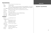
...Warm: Approximately 15 seconds Cold: Approximately 45 seconds AutoLocate: Approximately 2 minutes Update Rate: Once per second, continuous GPS Accuracy Position**: Range: 32° to 140°F (0° to 60°C) Infrared: Remote control, IR port... Photo Sensor: Senses lighting conditions for optional GPS antenna connection Temp. Physical Specifications Size: 5.6"W x 3.2"H x 2.0"D (14.3 x 8.0 x 5.0 cm) Weight: .93 pounds (420 g) Display: 3.3"W x 1.7"H (8.4 x 4.4 cm), (305 x 160 pixels), automotive-grade 8-bit, 256-color LCD with polarized sunglasses Case...
...Warm: Approximately 15 seconds Cold: Approximately 45 seconds AutoLocate: Approximately 2 minutes Update Rate: Once per second, continuous GPS Accuracy Position**: Range: 32° to 140°F (0° to 60°C) Infrared: Remote control, IR port... Photo Sensor: Senses lighting conditions for optional GPS antenna connection Temp. Physical Specifications Size: 5.6"W x 3.2"H x 2.0"D (14.3 x 8.0 x 5.0 cm) Weight: .93 pounds (420 g) Display: 3.3"W x 1.7"H (8.4 x 4.4 cm), (305 x 160 pixels), automotive-grade 8-bit, 256-color LCD with polarized sunglasses Case...
Owners Manual
Page 84
... outside the United States, where complete and accurate digital data is a precision navigation system any discrepancies before continuing navigation. THIS PRODUCT IS INTENDED TO BE USED ONLY AS A NAVIGATIONAL AID AND MUST NOT BE USED FOR ANY PURPOSE REQUIRING PRECISE MEASUREMENT OF DIRECTION... System (GPS) is solely responsible for its accuracy and maintenance. We use . To reduce the risk of unsafe operation, carefully review and understand all GPS equipment. CAUTION: IT IS THE USER'S RESPONSIBILITY TO USE THIS PRODUCT PRUDENTLY. Although the Garmin StreetPilot 2620/2660 is...
... outside the United States, where complete and accurate digital data is a precision navigation system any discrepancies before continuing navigation. THIS PRODUCT IS INTENDED TO BE USED ONLY AS A NAVIGATIONAL AID AND MUST NOT BE USED FOR ANY PURPOSE REQUIRING PRECISE MEASUREMENT OF DIRECTION... System (GPS) is solely responsible for its accuracy and maintenance. We use . To reduce the risk of unsafe operation, carefully review and understand all GPS equipment. CAUTION: IT IS THE USER'S RESPONSIBILITY TO USE THIS PRODUCT PRUDENTLY. Although the Garmin StreetPilot 2620/2660 is...
Owners Manual
Page 89
... Recently-Found Places 27 Waypoints 24 FIND Key 3 Friction Mount 61 Installing 62 Fuse, Vehicle Adapter 64 G Garmin Web Site 79 General Tab 45 Getting Started Tutorial iv GPS Info Page 56, 57, 58, 59, 60 GPS is Off 58 Guidance Tab 46 H Hard Drive 1 Available Space In 70 Caring For 2 Heading 43...
... Recently-Found Places 27 Waypoints 24 FIND Key 3 Friction Mount 61 Installing 62 Fuse, Vehicle Adapter 64 G Garmin Web Site 79 General Tab 45 Getting Started Tutorial iv GPS Info Page 56, 57, 58, 59, 60 GPS is Off 58 Guidance Tab 46 H Hard Drive 1 Available Space In 70 Caring For 2 Heading 43...

Owners Manual
Page 90
... 39 Orientation Icons 8 OUT Key 4 Overall Avg 16 Overzoom 9 P Packing List ii 82 PAGE Key 3 Panning 7 Panning Hand 7 Places, Finding 19 Planning a Trip 26 Poor GPS Coverage 58 Poor Satellite Reception 59 Power On/Off 5 Pre-Programmed Hard Drive. See Hard Drive Preface i Product Registration i Product Safety Information 75 R Recalculating a Route...
... 39 Orientation Icons 8 OUT Key 4 Overall Avg 16 Overzoom 9 P Packing List ii 82 PAGE Key 3 Panning 7 Panning Hand 7 Places, Finding 19 Planning a Trip 26 Poor GPS Coverage 58 Poor Satellite Reception 59 Power On/Off 5 Pre-Programmed Hard Drive. See Hard Drive Preface i Product Registration i Product Safety Information 75 R Recalculating a Route...

