
User Manual
Page 4
...with part 15 of the FCC Rules. UL Certification does not cover the performance or reliability of the Global Positioning System ("GPS") hardware, operating software or other factors that may affect safety or timing while driving. Operation is subject to the following ... road closures or road conditions, traffic congestion, weather conditions, or other aspects of this product. UL has only tested for aircraft navigation. Use the unit only as sunshine, fire or the like. UL MAKES NO REPRESENTATIONS, WARRANTIES OR CERTIFICATIONS WHATSOEVER REGARDING THE PERFORMANCE ...
...with part 15 of the FCC Rules. UL Certification does not cover the performance or reliability of the Global Positioning System ("GPS") hardware, operating software or other factors that may affect safety or timing while driving. Operation is subject to the following ... road closures or road conditions, traffic congestion, weather conditions, or other aspects of this product. UL has only tested for aircraft navigation. Use the unit only as sunshine, fire or the like. UL MAKES NO REPRESENTATIONS, WARRANTIES OR CERTIFICATIONS WHATSOEVER REGARDING THE PERFORMANCE ...

X3-T Software
Page 3
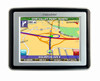
... To use the system to guide you have read and agreed to a destination, the system's GPS antenna must be obstructed by the roof of the sky. - 3 - The screen appears. 2 Tap Navigate. GPS signals can also be obstructed by ceilings, trees, and nearby tall buildings. For best results, position your system where it has...
... To use the system to guide you have read and agreed to a destination, the system's GPS antenna must be obstructed by the roof of the sky. - 3 - The screen appears. 2 Tap Navigate. GPS signals can also be obstructed by ceilings, trees, and nearby tall buildings. For best results, position your system where it has...
X3-T Software
Page 6
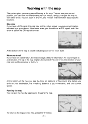
... your next turn and the distance to that turn. Panning the map You can pan the map by a green arrow. Map view If you have a GPS signal, the map view on a route, and you do not have set a destination, the map displays additional information. As you see your current speed. You... next street, the direction of the maneuvers on the system shows you have a GPS signal, and if the arrow is yellow the GPS signal is a scale indicating your current zoom level. At the bottom of the map you navigate to your destination, and your current position, you can view any of your current...
... your next turn and the distance to that turn. Panning the map You can pan the map by a green arrow. Map view If you have a GPS signal, the map view on a route, and you do not have set a destination, the map displays additional information. As you see your current speed. You... next street, the direction of the maneuvers on the system shows you have a GPS signal, and if the arrow is yellow the GPS signal is a scale indicating your current zoom level. At the bottom of the map you navigate to your destination, and your current position, you can view any of your current...


