
User Manual
Page 4
... UL standard]. UL MAKES NO REPRESENTATIONS, WARRANTIES OR CERTIFICATIONS WHATSOEVER REGARDING THE PERFORMANCE OR RELIABILITY OF ANY GPS RELATED FUNCTIONS OF THIS PRODUCT. This product should not be exposed to excessive heat such as a navigational aid. UL has only tested for fire, shock or casualty hazards as outlined in injury or property...
... UL standard]. UL MAKES NO REPRESENTATIONS, WARRANTIES OR CERTIFICATIONS WHATSOEVER REGARDING THE PERFORMANCE OR RELIABILITY OF ANY GPS RELATED FUNCTIONS OF THIS PRODUCT. This product should not be exposed to excessive heat such as a navigational aid. UL has only tested for fire, shock or casualty hazards as outlined in injury or property...

X3-T Software
Page 3
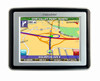
... also be obstructed by the roof of the sky. - 3 - Signals can be obstructed by ceilings, trees, and nearby tall buildings. Getting a GPS signal To use the system to guide you have read and agreed to the warning. A warning screen appears. 3 Tap "I Agree" after you to... set your system where it has a clear view of your vehicle. The screen appears. 2 Tap Navigate. The map view appears and you are ready to a destination, the system's GPS antenna must be receiving signals. For best results, position your first destination! To start the system: 1 Press the POWER...
... also be obstructed by the roof of the sky. - 3 - Signals can be obstructed by ceilings, trees, and nearby tall buildings. Getting a GPS signal To use the system to guide you have read and agreed to the warning. A warning screen appears. 3 Tap "I Agree" after you to... set your system where it has a clear view of your vehicle. The screen appears. 2 Tap Navigate. The map view appears and you are ready to a destination, the system's GPS antenna must be receiving signals. For best results, position your first destination! To start the system: 1 Press the POWER...
X3-T Software
Page 6
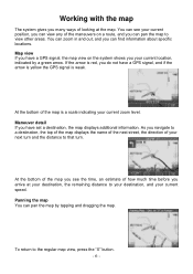
Map view If you have a GPS signal, the map view on a route, and you can pan the map by a green arrow.... - 6 - At the bottom of the map is a scale indicating your next turn and the distance to that turn. As you navigate to a destination, the top of the map displays the name of the next street, the direction of your current zoom level. You... an estimate of how much time before you arrive at the map. Maneuver detail If you have a GPS signal, and if the arrow is yellow the GPS signal is red, you do not have set a destination, the map displays additional information. You can...
Map view If you have a GPS signal, the map view on a route, and you can pan the map by a green arrow.... - 6 - At the bottom of the map is a scale indicating your next turn and the distance to that turn. As you navigate to a destination, the top of the map displays the name of the next street, the direction of your current zoom level. You... an estimate of how much time before you arrive at the map. Maneuver detail If you have a GPS signal, and if the arrow is yellow the GPS signal is red, you do not have set a destination, the map displays additional information. You can...


