Manual - English (for the UK)
Page 1
Magellan eXplorist 400 Reference Manual Topics: • eXplorist 400 GPS Receiver • Using the eXplorist 400 • Starting Up • Navigation Screens • File Structure • Points of Interest • Routes • Track Logs • Advanced Features • Magellan Geocache Manager • Using MapSend • Preferences • Specifications • Accessories • Contacting Magellan Support
Magellan eXplorist 400 Reference Manual Topics: • eXplorist 400 GPS Receiver • Using the eXplorist 400 • Starting Up • Navigation Screens • File Structure • Points of Interest • Routes • Track Logs • Advanced Features • Magellan Geocache Manager • Using MapSend • Preferences • Specifications • Accessories • Contacting Magellan Support
Manual - English (for the UK)
Page 2
... in accordance with the product. The SOFTWARE is the property of Defense civil GPS user policy and the Federal Radionavigation Plan. therefore, you must accept any means, electronic or mechanical, including photocopying and recording, for navigating. The Magellan Logo, Magellan, eXplorist and TrueFix are reserved by Thales Navigation and/or its suppliers and is...
... in accordance with the product. The SOFTWARE is the property of Defense civil GPS user policy and the Federal Radionavigation Plan. therefore, you must accept any means, electronic or mechanical, including photocopying and recording, for navigating. The Magellan Logo, Magellan, eXplorist and TrueFix are reserved by Thales Navigation and/or its suppliers and is...
Manual - English (for the UK)
Page 3
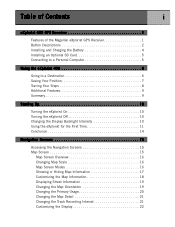
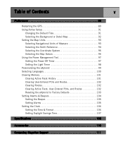
Table of Contents i eXplorist 400 GPS Receiver 1 Features of the Magellan eXplorist GPS Receiver 1 Button Descriptions 2 Installing and Charging the Battery 4 Installing an Optional SD Card 5 Connecting to a Personal Computer 5 Using the eXplorist 400 6 Going to a Destination 6 Saving Your Position 7 Tracing Your Steps 8 Additional Features 9 Summary 9 Starting Up 10 Turning the eXplorist On 10 Turning the eXplorist Off 10 Changing the...
Table of Contents i eXplorist 400 GPS Receiver 1 Features of the Magellan eXplorist GPS Receiver 1 Button Descriptions 2 Installing and Charging the Battery 4 Installing an Optional SD Card 5 Connecting to a Personal Computer 5 Using the eXplorist 400 6 Going to a Destination 6 Saving Your Position 7 Tracing Your Steps 8 Additional Features 9 Summary 9 Starting Up 10 Turning the eXplorist On 10 Turning the eXplorist Off 10 Changing the...
Manual - English (for the UK)
Page 7
Table of Contents v Preferences 88 Restarting the GPS 89 Using Active Setup 91 Changing the Default Files 91 Selecting...the Power Management Tool 97 Setting the Power-Off Timer 97 Setting the Light Timer 98 Personalizing the eXplorist 99 Selecting Languages 100 Clearing Memory 101 Clearing Active Track History 101 Clearing User-Entered POIs and ...Routes 102 Clearing Routes 102 Clearing Active Track, User-Entered POIs, and Routes 102 Reseting the eXplorist to Factory Defaults 103 Setting Alarms & Beepers 104 Setting the Beeper 105 Setting Alarms 105 Setting the Clock ...
Table of Contents v Preferences 88 Restarting the GPS 89 Using Active Setup 91 Changing the Default Files 91 Selecting...the Power Management Tool 97 Setting the Power-Off Timer 97 Setting the Light Timer 98 Personalizing the eXplorist 99 Selecting Languages 100 Clearing Memory 101 Clearing Active Track History 101 Clearing User-Entered POIs and ...Routes 102 Clearing Routes 102 Clearing Active Track, User-Entered POIs, and Routes 102 Reseting the eXplorist to Factory Defaults 103 Setting Alarms & Beepers 104 Setting the Beeper 105 Setting Alarms 105 Setting the Clock ...
Manual - English (for the UK)
Page 8
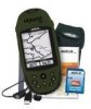
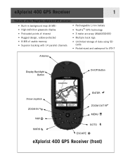
eXplorist 400 GPS Receiver 1 Features of the Magellan eXplorist GPS receiver: • Built-in background map (8 MB) • High-definition grayscale display • Preloaded points of interest • Rugged design, rubber-protected • 8 MB of usable memory • Superior tracking with 14 parallel channels • Rechargeable Li-Ion battery • TrueFix™ GPS technology • 3 meter accuracy (WAAS...
eXplorist 400 GPS Receiver 1 Features of the Magellan eXplorist GPS receiver: • Built-in background map (8 MB) • High-definition grayscale display • Preloaded points of interest • Rugged design, rubber-protected • 8 MB of usable memory • Superior tracking with 14 parallel channels • Rechargeable Li-Ion battery • TrueFix™ GPS technology • 3 meter accuracy (WAAS...

Manual - English (for the UK)
Page 9
... to quickly step through the list of the database. Used to 100 ft. (35.0 m). Also used to access it. Brings up a menu with available options. eXplorist 400 GPS Receiver 2 Button Descriptions: On/Off Backlight ENTER ESCAPE ZOOM IN ZOOM OUT MENU NAV MARK GOTO Arrow joystick Turns the... eXplorist on the Map screen. Steps through the navigation screens. Creates a one-leg route from the Points of interest. The map display can be zoomed out ...
... to quickly step through the list of the database. Used to 100 ft. (35.0 m). Also used to access it. Brings up a menu with available options. eXplorist 400 GPS Receiver 2 Button Descriptions: On/Off Backlight ENTER ESCAPE ZOOM IN ZOOM OUT MENU NAV MARK GOTO Arrow joystick Turns the... eXplorist on the Map screen. Steps through the navigation screens. Creates a one-leg route from the Points of interest. The map display can be zoomed out ...

Manual - English (for the UK)
Page 10
eXplorist 400 GPS Receiver Wrist Lanyard Strap Mounting Hole Battery Door 3 Connector for external power and connection to install batteries.) eXplorist 400 GPS Receiver (back) Battery Door Fastener (Unscrew to open battery door to a personal computer.
eXplorist 400 GPS Receiver Wrist Lanyard Strap Mounting Hole Battery Door 3 Connector for external power and connection to install batteries.) eXplorist 400 GPS Receiver (back) Battery Door Fastener (Unscrew to open battery door to a personal computer.

Manual - English (for the UK)
Page 11
...to be at the same rate. You should use the Light Timer to set a time that the display backlight will automatically turn the eXplorist off . Charging the Battery: Important: Charge the battery completely before first using power at the same position for a selected time. ...Pwr Management and press ENTER twice. Press ENTER. Use the arrow joystick to an AC wall outlet. Highlight Preferences and press ENTER. eXplorist 400 GPS Receiver 4 Installing and Charging the Battery Installing the Battery: Remove the battery door by unscrewing the battery door fastener and lifting the...
...to be at the same rate. You should use the Light Timer to set a time that the display backlight will automatically turn the eXplorist off . Charging the Battery: Important: Charge the battery completely before first using power at the same position for a selected time. ...Pwr Management and press ENTER twice. Press ENTER. Use the arrow joystick to an AC wall outlet. Highlight Preferences and press ENTER. eXplorist 400 GPS Receiver 4 Installing and Charging the Battery Installing the Battery: Remove the battery door by unscrewing the battery door fastener and lifting the...

Manual - English (for the UK)
Page 12
... ports (normally found a new USB hardware device. The other end of your personal computer). You will see a message on the back of the eXplorist data cable has a standard USB connector that it locks into place. Put the LI-ION battery back in the battery compartment as damage will be... using the external AC power adapter. You may see a device named "Removable Disk" listed which will occur when closing the SD Card Cradle. eXplorist 400 GPS Receiver Installing an Optional SD Card Open the battery door and remove the LI-ION battery, exposing the SD Card Cradle. Do NOT lay the...
... ports (normally found a new USB hardware device. The other end of your personal computer). You will see a message on the back of the eXplorist data cable has a standard USB connector that it locks into place. Put the LI-ION battery back in the battery compartment as damage will be... using the external AC power adapter. You may see a device named "Removable Disk" listed which will occur when closing the SD Card Cradle. eXplorist 400 GPS Receiver Installing an Optional SD Card Open the battery door and remove the LI-ION battery, exposing the SD Card Cradle. Do NOT lay the...

Manual - English (for the UK)
Page 13
... be to provide you with the navigation tools you'll need at least three satellites with good signal strength. Positions that your eXplorist will graphically see the satellites and their signal strength, switch to compute your position. Here, you need to do is not ...One: Compute Your Position The basic operation of the sky. This is to use the GPS satellites to your position fix, you will use four or more satellites are being computed. Using the eXplorist 400 6 The eXplorist 400 uses information from the GPS satellites orbiting the earth to arrive at your destination.
... be to provide you with the navigation tools you'll need at least three satellites with good signal strength. Positions that your eXplorist will graphically see the satellites and their signal strength, switch to compute your position. Here, you need to do is not ...One: Compute Your Position The basic operation of the sky. This is to use the GPS satellites to your position fix, you will use four or more satellites are being computed. Using the eXplorist 400 6 The eXplorist 400 uses information from the GPS satellites orbiting the earth to arrive at your destination.

Manual - English (for the UK)
Page 30
... active route, the graphical compass performs like a standard compass, indicating to your heading as referenced to true north. (Note: You must be familiar to most GPS users. Highlights of the Compass screen: • With an active route, the top of the Compass screen displays the name of the destination. • Press...
... active route, the graphical compass performs like a standard compass, indicating to your heading as referenced to true north. (Note: You must be familiar to most GPS users. Highlights of the Compass screen: • With an active route, the top of the Compass screen displays the name of the destination. • Press...
Manual - English (for the UK)
Page 32
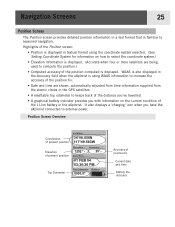
... the position.) • Computed accuracy of the position computed is displayed. WAAS is also displayed in the Accuracy field when the eXplorist is using the coordinate system selected. (See Setting Coordinate System for information on the current condition of the LI-Ion battery in the... is displayed. (Accurate when four or more satellites are shown, automatically adjusted from time information supplied from the atomic clocks in the GPS satellites. • A resettable trip odometer to keeps track of the distance you've travelled. • A graphical battery indicator provides you have the...
... the position.) • Computed accuracy of the position computed is displayed. WAAS is also displayed in the Accuracy field when the eXplorist is using the coordinate system selected. (See Setting Coordinate System for information on the current condition of the LI-Ion battery in the... is displayed. (Accurate when four or more satellites are shown, automatically adjusted from time information supplied from the atomic clocks in the GPS satellites. • A resettable trip odometer to keeps track of the distance you've travelled. • A graphical battery indicator provides you have the...
Manual - English (for the UK)
Page 35
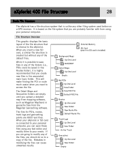
...you are empty until you upload a detailed map from mapping software, such as Magellan MapSend or geocache files from using any text editor and modify them to your needs. When your eXplorist or SD card is unlike any other filing system used before on the file ...Empty It is based on a GPS receiver. The files for POIs, routes, track logs and geocaching points are ASCII text files. eXplorist 400 File Structure 28 Basic File Structure The eXplorist has a file structure system that you are probably familiar with from the Magellan Geocaching software. This will make ...
...you are empty until you upload a detailed map from mapping software, such as Magellan MapSend or geocache files from using any text editor and modify them to your needs. When your eXplorist or SD card is unlike any other filing system used before on the file ...Empty It is based on a GPS receiver. The files for POIs, routes, track logs and geocaching points are ASCII text files. eXplorist 400 File Structure 28 Basic File Structure The eXplorist has a file structure system that you are probably familiar with from the Magellan Geocaching software. This will make ...

Manual - English (for the UK)
Page 38
... and press ENTER. The second method provides you with the means to personalize POIs you are called "Marking Your position" or just MARK for any GPS navigator. Press ENTER. 3. Points of Interest 31 Whether driving in a car, hiking on the trail, or out for an afternoon sail, you are going... and message of positions you to confirm that will be described will be quickmarking your position. There are four types of POIs available for your eXplorist 400: POIs that you still want to save the POI in the database using the geocaching software, and POIs that was not computed, that you ...
... and press ENTER. The second method provides you with the means to personalize POIs you are called "Marking Your position" or just MARK for any GPS navigator. Press ENTER. 3. Points of Interest 31 Whether driving in a car, hiking on the trail, or out for an afternoon sail, you are going... and message of positions you to confirm that will be described will be quickmarking your position. There are four types of POIs available for your eXplorist 400: POIs that you still want to save the POI in the database using the geocaching software, and POIs that was not computed, that you ...

Manual - English (for the UK)
Page 51
...they are the least understood and one -leg route with a starting point (your present position) and a destination (a POI you travel the eXplorist records your eXplorist. If a GOTO route is not described in this track information and creates a multi-leg route, in reverse order, enabling you understand ...8226; A straight line from the POI database. • GOTO routes can be saved in the Cursor mode of a GPS receiver. but these routes are erased when the eXplorist is a one of the most important functions of the Map screen. GOTO Routes A GOTO route is the most common form...
...they are the least understood and one -leg route with a starting point (your present position) and a destination (a POI you travel the eXplorist records your eXplorist. If a GOTO route is not described in this track information and creates a multi-leg route, in reverse order, enabling you understand ...8226; A straight line from the POI database. • GOTO routes can be saved in the Cursor mode of a GPS receiver. but these routes are erased when the eXplorist is a one of the most important functions of the Map screen. GOTO Routes A GOTO route is the most common form...
Manual - English (for the UK)
Page 83
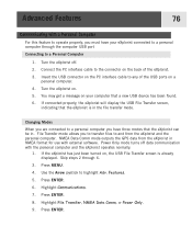
... the PC interface cable to the connector on . 5. NMEA Data Comm mode outputs the GPS data from the eXplorist and the personal computer. Highlight Communications. 7. You may get a message on your eXplorist connected to a personal computer through 6. 3. Changing Modes When you are connected to a ...found. 6. File Transfer mode allows you to transfer files to and from the eXplorist in NMEA format for use with external software. Use the Arrow joystick to any of the eXplorist. 3. If the eXplorist has just been turned on a personal computer. 4. Features. 5. Advanced Features...
... the PC interface cable to the connector on . 5. NMEA Data Comm mode outputs the GPS data from the eXplorist and the personal computer. Highlight Communications. 7. You may get a message on your eXplorist connected to a personal computer through 6. 3. Changing Modes When you are connected to a ...found. 6. File Transfer mode allows you to transfer files to and from the eXplorist in NMEA format for use with external software. Use the Arrow joystick to any of the eXplorist. 3. If the eXplorist has just been turned on a personal computer. 4. Features. 5. Advanced Features...
Manual - English (for the UK)
Page 90
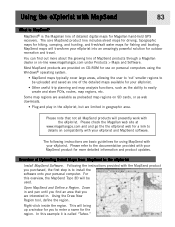
...In this overview, the MapSend Topo 3D will presently work with the eXplorist. Some map regions are basic guidelines for use on compatibility with your eXplorist into an amazingly powerful solution for Magellan hand-held GPS receivers. Please note that you are provided on CD-ROM for using... region. Most MapSend products are interested in geographic area. This will transform your eXplorist and MapSend software. MapSend maps will bring up a window for you purchased, the first step is the Magellan line of Uploading Detail Maps from MapSend to enter a name for fishing and ...
...In this overview, the MapSend Topo 3D will presently work with the eXplorist. Some map regions are basic guidelines for use on compatibility with your eXplorist into an amazingly powerful solution for Magellan hand-held GPS receivers. Please note that you are provided on CD-ROM for using... region. Most MapSend products are interested in geographic area. This will transform your eXplorist and MapSend software. MapSend maps will bring up a window for you purchased, the first step is the Magellan line of Uploading Detail Maps from MapSend to enter a name for fishing and ...

Manual - English (for the UK)
Page 91
...is displayed. Under the Regions menu, select "Upload to set what information will not work in the eXplorist. You will come up in the region list make sure that came with MapSend to GPS..." (Ctrl+U). In this example, Topo information and POIs are wanted, so in the USB File ...Transfer mode. (If not, and the Communication screen is : Local Disk C:\Program Files\Magellan\'MapSend Product Name'\Export\Images. Select USB File Transfer ...
...is displayed. Under the Regions menu, select "Upload to set what information will not work in the eXplorist. You will come up in the region list make sure that came with MapSend to GPS..." (Ctrl+U). In this example, Topo information and POIs are wanted, so in the USB File ...Transfer mode. (If not, and the Communication screen is : Local Disk C:\Program Files\Magellan\'MapSend Product Name'\Export\Images. Select USB File Transfer ...
Manual - English (for the UK)
Page 93
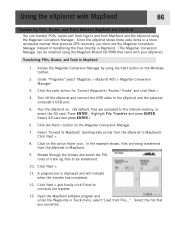
... POIs, Routes, and Track Between MapSend and eXplorist You can be transferred. 10, Click Next >. 11. Since the eXplorist stores these data items in a more accessible manner than previous GPS receivers, you converted. Select SD card and press...eXplorist to MapSend). Access the Magellan Conversion Manager by using the Start button on the Magellan Conversion Manager. 7. Under "Programs" select 'Magellan > eXplorist 400 > Magellan Conversion Manager'. 3. Click Next > and finally click Finish to and from the eXplorist to MapSend. 9. Using the eXplorist with your eXplorist...
... POIs, Routes, and Track Between MapSend and eXplorist You can be transferred. 10, Click Next >. 11. Since the eXplorist stores these data items in a more accessible manner than previous GPS receivers, you converted. Select SD card and press...eXplorist to MapSend). Access the Magellan Conversion Manager by using the Start button on the Magellan Conversion Manager. 7. Under "Programs" select 'Magellan > eXplorist 400 > Magellan Conversion Manager'. 3. Click Next > and finally click Finish to and from the eXplorist to MapSend. 9. Using the eXplorist with your eXplorist...

Manual - English (for the UK)
Page 95
Features found in Preferences: • Restarting the GPS (Initializing) to give the eXplorist its approximate location if it has been moved a large distance while turned off. • A way of setting default folders for saving POI's, routes, etc. • ... information displayed. • A means to set alarms to your usage and needs. Preferences 88 The Preferences portion of the eXplorist provides the tools to personalize the eXplorist to alert you when you have lost GPS signal, when you are getting near your destination, and other useful alerts. • A way of resetting the clock...
Features found in Preferences: • Restarting the GPS (Initializing) to give the eXplorist its approximate location if it has been moved a large distance while turned off. • A way of setting default folders for saving POI's, routes, etc. • ... information displayed. • A means to set alarms to your usage and needs. Preferences 88 The Preferences portion of the eXplorist provides the tools to personalize the eXplorist to alert you when you have lost GPS signal, when you are getting near your destination, and other useful alerts. • A way of resetting the clock...


