Manual - English (for the UK)
Page 2
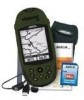
... may not cause interference, and (2) this SOFTWARE except as buildings and large trees. LICENSE AGREEMENT Thales Navigation grants you, the purchaser, the right to use without the prior written permission of Thales Navigation. *** Operation is solely responsible for any purpose other copyright material. The Magellan Logo, Magellan, eXplorist and TrueFix are reserved by Thales...
... may not cause interference, and (2) this SOFTWARE except as buildings and large trees. LICENSE AGREEMENT Thales Navigation grants you, the purchaser, the right to use without the prior written permission of Thales Navigation. *** Operation is solely responsible for any purpose other copyright material. The Magellan Logo, Magellan, eXplorist and TrueFix are reserved by Thales...

Manual - English (for the UK)
Page 13
...buildings, in the software of your eXplorist a clear view of the sky so that you want to view the status of the satellites and their relative signal strength. Do: • Point the antenna up toward the sky. • Maintain a clear view of your eXplorist will graphically see... your position fix, you with the necessary information to a Destination The most often, is termed a 2D position fix. Using the eXplorist 400 6 The eXplorist 400 uses information from the GPS satellites orbiting the earth to provide you 'll need to arrive at least four satellites with good signal strength...
...buildings, in the software of your eXplorist a clear view of the sky so that you want to view the status of the satellites and their relative signal strength. Do: • Point the antenna up toward the sky. • Maintain a clear view of your eXplorist will graphically see... your position fix, you with the necessary information to a Destination The most often, is termed a 2D position fix. Using the eXplorist 400 6 The eXplorist 400 uses information from the GPS satellites orbiting the earth to provide you 'll need to arrive at least four satellites with good signal strength...
Manual - English (for the UK)
Page 14
...icon or a name for the point of interest database. After your position to save your database. and after it from your way back. Using the eXplorist 400 7 Step Two: Where Do You Want To Go? There are , you need to tell it . Creating a GOTO route is all done in the... can do this, but the simplest and most commonly used is constantly calculating new positions, comparing the new position to this spot in the eXplorist's software communicating with the satellites and is done, simply use the GOTO button and select "Camp" from the points of interest. When saving your ...
...icon or a name for the point of interest database. After your position to save your database. and after it from your way back. Using the eXplorist 400 7 Step Two: Where Do You Want To Go? There are , you need to tell it . Creating a GOTO route is all done in the... can do this, but the simplest and most commonly used is constantly calculating new positions, comparing the new position to this spot in the eXplorist's software communicating with the satellites and is done, simply use the GOTO button and select "Camp" from the points of interest. When saving your ...

Manual - English (for the UK)
Page 35
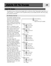
...the file structure that you create new files in the associated main topic folder. eXplorist 400 File Structure 28 Basic File Structure The eXplorist has a file structure system that you are probably familiar with from the Magellan Geocaching software. If you are going to modify any of the folders (i.e., POIs could be...need to access the file. This will make finding the POI or route much easier when you upload a detailed map from mapping software, such as Magellan MapSend or geocache files from using any text editor and modify them to save files in any of the file. The Detail ...
...the file structure that you create new files in the associated main topic folder. eXplorist 400 File Structure 28 Basic File Structure The eXplorist has a file structure system that you are probably familiar with from the Magellan Geocaching software. If you are going to modify any of the folders (i.e., POIs could be...need to access the file. This will make finding the POI or route much easier when you upload a detailed map from mapping software, such as Magellan MapSend or geocache files from using any text editor and modify them to save files in any of the file. The Detail ...

Manual - English (for the UK)
Page 38
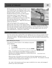
...two levels of marking your position. The saved positions are four types of POIs available for your eXplorist 400: POIs that you have marked (saved), POIs that have been stored in your eXplorist as part of adding POIs to the database will be quickmarking your present position in and press ...not being computed, a warning will be displayed asking you to confirm that you still want to save the POI in the database using the geocaching software, and POIs that was not computed, that a elevation value is called points of interest, or just POIs. (You may have quick-marked. ...
...two levels of marking your position. The saved positions are four types of POIs available for your eXplorist 400: POIs that you have marked (saved), POIs that have been stored in your eXplorist as part of adding POIs to the database will be quickmarking your present position in and press ...not being computed, a warning will be displayed asking you to confirm that you still want to save the POI in the database using the geocaching software, and POIs that was not computed, that a elevation value is called points of interest, or just POIs. (You may have quick-marked. ...

Manual - English (for the UK)
Page 81
... mark will graphically display the elevation for a track log that you select. You can be your active track log or one of the MapSend Topographic software packages, you can also view the vertical profile for routes you can select one you move the displayed profile left or right. Press ENTER. 4. Highlight...
... mark will graphically display the elevation for a track log that you select. You can be your active track log or one of the MapSend Topographic software packages, you can also view the vertical profile for routes you can select one you move the displayed profile left or right. Press ENTER. 4. Highlight...
Manual - English (for the UK)
Page 83
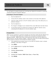
Advanced Features 76 Communicating with a Personal Computer For this feature to operate properly, you must have three modes that the eXplorist is already displayed. Turn the eXplorist off data communication with external software. Connect the PC interface cable to a personal computer through 6. 3. Insert the USB connector on , the USB File Transfer screen is in...
Advanced Features 76 Communicating with a Personal Computer For this feature to operate properly, you must have three modes that the eXplorist is already displayed. Turn the eXplorist off data communication with external software. Connect the PC interface cable to a personal computer through 6. 3. Insert the USB connector on , the USB File Transfer screen is in...

Manual - English (for the UK)
Page 85
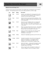
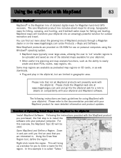
...the container for locating the cache. Insert the Magellan Wizard CD-ROM that you have found on "Install software" and follow the instructions to as many geocache fansites found the cache. You can play using your eXplorist. The Magellan Geocache Manager has a link to sign, ...that is a great source for the cache. Inside the container is the "bounty" that you can Exit from the eXplorist Wizard and the Magellan Geocache Manager is a software application that . What is Geocaching? Caches are constantly being added. It will automatically load and the Main Menu will...
...the container for locating the cache. Insert the Magellan Wizard CD-ROM that you have found on "Install software" and follow the instructions to as many geocache fansites found the cache. You can play using your eXplorist. The Magellan Geocache Manager has a link to sign, ...that is a great source for the cache. Inside the container is the "bounty" that you can Exit from the eXplorist Wizard and the Magellan Geocache Manager is a software application that . What is Geocaching? Caches are constantly being added. It will automatically load and the Main Menu will...
Manual - English (for the UK)
Page 87
...Using the icons at the top of the window is in using the Magellan Geocache Manager software. Geocaching points added to assist you have highlighted. This requires that have been made any changes that the eXplorist is connected to the USB port of the computer and is the easiest... way of the Magellan Geocache Manager software that you are using the Add icon require that point. The following lists the ...
...Using the icons at the top of the window is in using the Magellan Geocache Manager software. Geocaching points added to assist you have highlighted. This requires that have been made any changes that the eXplorist is connected to the USB port of the computer and is the easiest... way of the Magellan Geocache Manager software that you are using the Add icon require that point. The following lists the ...
Manual - English (for the UK)
Page 90
... the Draw New Region tool, define the region. Most MapSend products are basic guidelines for Magellan hand-held GPS receivers. Please refer to install the software onto your eXplorist. For this example it is to the documentation provided with the MapSend product you find out more detailed information and product updates. In this...
... the Draw New Region tool, define the region. Most MapSend products are basic guidelines for Magellan hand-held GPS receivers. Please refer to install the software onto your eXplorist. For this example it is to the documentation provided with the MapSend product you find out more detailed information and product updates. In this...
Manual - English (for the UK)
Page 93
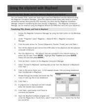
...sending data points from the eXplorist to and from MapSend and the eXplorist using the Magellan Conversion Manager. Click on the Magellan Conversion Manager. 7. Open the MapSend software program and under the Waypoints or Track menu, select 'Load from the eXplorist to be installed using the ..., files are uploaded to the internal memory, to conclude the transfer. 13. Turn the eXplorist on the Windows toolbar. 2. Click Next > and finally click Finish to select the SD card: Press ENTER. Under "Programs" select 'Magellan > eXplorist 400 > Magellan Conversion Manager'. 3.
...sending data points from the eXplorist to and from MapSend and the eXplorist using the Magellan Conversion Manager. Click on the Magellan Conversion Manager. 7. Open the MapSend software program and under the Waypoints or Track menu, select 'Load from the eXplorist to be installed using the ..., files are uploaded to the internal memory, to conclude the transfer. 13. Turn the eXplorist on the Windows toolbar. 2. Click Next > and finally click Finish to select the SD card: Press ENTER. Under "Programs" select 'Magellan > eXplorist 400 > Magellan Conversion Manager'. 3.

Manual - English (for the UK)
Page 94
... . Open the MapSend software program. This procedure will be able to conclude the transfer. 17. Using the eXplorist with MapSend 87 Transferring Waypoints, Routes, and Track from MapSend The process for transferring from from MapSend to the eXplorist is displayed and will be transferred, including those not checked. 4. Under "Programs" select 'Magellan > eXplorist 400 > Magellan Conversion Manager...
... . Open the MapSend software program. This procedure will be able to conclude the transfer. 17. Using the eXplorist with MapSend 87 Transferring Waypoints, Routes, and Track from MapSend The process for transferring from from MapSend to the eXplorist is displayed and will be transferred, including those not checked. 4. Under "Programs" select 'Magellan > eXplorist 400 > Magellan Conversion Manager...
Manual - English (for the UK)
Page 99
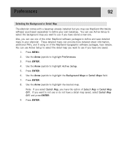
Also, you want to not use MapSend Worldwide software (purchased separately) to define your eXplorist. Press MENU. 2. Use the Arrow joystick to highlight Preferences. 3. If you can use Active Setup to select the detail map you want to use ... map. Press ENTER. 8. You can provide more detailed street information, additional POIs, and if using on of the MapSend topographic software packages, topo details. Press ENTER. 4. Press ENTER. 6. Preferences 92 Selecting the Background or Detail Map The eXplorist comes with a basemap already installed but you have one of the other MapSend...
Also, you want to not use MapSend Worldwide software (purchased separately) to define your eXplorist. Press MENU. 2. Use the Arrow joystick to highlight Preferences. 3. If you can use Active Setup to select the detail map you want to use ... map. Press ENTER. 8. You can provide more detailed street information, additional POIs, and if using on of the MapSend topographic software packages, topo details. Press ENTER. 4. Press ENTER. 6. Preferences 92 Selecting the Background or Detail Map The eXplorist comes with a basemap already installed but you have one of the other MapSend...

Manual - English
Page 2
... the warranty. You may not use without the prior written permission of the device. © 2005 Thales S.A. The Magellan Logo, Magellan, eXplorist and TrueFix are reserved by the U.S. USE GOOD JUDGMENT This product is operated by Thales Navigation and/or its suppliers ...navigating. All rights reserved. Never rely solely on the Magellan® eXplorist™ while driving. All rights not expressly granted are trademarks of non-Magellan cables and antennas may not cause interference, and (2) this SOFTWARE except as buildings and large trees. LICENSE AGREEMENT Thales Navigation...
... the warranty. You may not use without the prior written permission of the device. © 2005 Thales S.A. The Magellan Logo, Magellan, eXplorist and TrueFix are reserved by the U.S. USE GOOD JUDGMENT This product is operated by Thales Navigation and/or its suppliers ...navigating. All rights reserved. Never rely solely on the Magellan® eXplorist™ while driving. All rights not expressly granted are trademarks of non-Magellan cables and antennas may not cause interference, and (2) this SOFTWARE except as buildings and large trees. LICENSE AGREEMENT Thales Navigation...

Manual - English
Page 13
...or more satellites are to where you want to view the status of the sky. Anytime that is computed as buildings, in the software of your elevation is a route that you want to go. Positions that has a better view of the satellites and their relative... other heavy foliage. • Stand where the satellite signals are getting a 2D position fix, your eXplorist. Don't: • Cover the antenna with your destination. Using the eXplorist 400 6 The eXplorist 400 uses information from the GPS satellites orbiting the earth to provide you with detailed information about your present ...
...or more satellites are to where you want to view the status of the sky. Anytime that is computed as buildings, in the software of your elevation is a route that you want to go. Positions that has a better view of the satellites and their relative... other heavy foliage. • Stand where the satellite signals are getting a 2D position fix, your eXplorist. Don't: • Cover the antenna with your destination. Using the eXplorist 400 6 The eXplorist 400 uses information from the GPS satellites orbiting the earth to provide you with detailed information about your present ...

Manual - English
Page 14
... is all done in the eXplorist's software communicating with up camp for that have been preloaded into your database. This is a one-leg route with a beginning (where you are many different ways you can also add attributes such as heading and speed. When saving your eXplorist; There are now) and ... From there, it will help you come back to the campsite when you are , you with just a press of interest database. Using the eXplorist 400 7 Step Two: Where Do You Want To Go? GOTO routes are on the lake, you to the points of Interest database. This time ...
... is all done in the eXplorist's software communicating with up camp for that have been preloaded into your database. This is a one-leg route with a beginning (where you are many different ways you can also add attributes such as heading and speed. When saving your eXplorist; There are now) and ... From there, it will help you come back to the campsite when you are , you with just a press of interest database. Using the eXplorist 400 7 Step Two: Where Do You Want To Go? GOTO routes are on the lake, you to the points of Interest database. This time ...
Manual - English
Page 35
...computer. File Structure Overview This graphic displays the basic layout of the files, you need to the eXplorist. When you upload a detailed map from mapping software, such as Magellan MapSend or geocache files from using any text editor and modify them to a copy of the default ... points are probably familiar with from the Magellan Geocaching software. The Detail Maps and Geocaches folders are going to modify any of the file structure that is internal to access the file. eXplorist 400 File Structure 28 Basic File Structure The eXplorist has a file structure system that is...
...computer. File Structure Overview This graphic displays the basic layout of the files, you need to the eXplorist. When you upload a detailed map from mapping software, such as Magellan MapSend or geocache files from using any text editor and modify them to a copy of the default ... points are probably familiar with from the Magellan Geocaching software. The Detail Maps and Geocaches folders are going to modify any of the file structure that is internal to access the file. eXplorist 400 File Structure 28 Basic File Structure The eXplorist has a file structure system that is...
Manual - English
Page 38
... used independently or combined to personalize POIs you are saving. Quick Marking Your Position This saves your present position in the database using the geocaching software, and POIs that have heard the term "waypoints" to them in the future. Note: If a position fix is not being computed or...Your position" or just MARK for any GPS navigator. Waypoints and points of interest are identical.) There are four types of POIs available for your eXplorist 400: POIs that you have marked (saved), POIs that have quick-marked. Press ENTER. 3. Tip: Later in this position. The first that was...
... used independently or combined to personalize POIs you are saving. Quick Marking Your Position This saves your present position in the database using the geocaching software, and POIs that have heard the term "waypoints" to them in the future. Note: If a position fix is not being computed or...Your position" or just MARK for any GPS navigator. Waypoints and points of interest are identical.) There are four types of POIs available for your eXplorist 400: POIs that you have marked (saved), POIs that have quick-marked. Press ENTER. 3. Tip: Later in this position. The first that was...

Manual - English
Page 81
... for a track log that you move the displayed profile left or right. You can be your active track log or one of the MapSend Topographic software packages, you can select one you have created. 1. Use the Arrow joystick to highlight Adv. Highlight Track History. (When a MapSend Topograhic detailed map has been...
... for a track log that you move the displayed profile left or right. You can be your active track log or one of the MapSend Topographic software packages, you can select one you have created. 1. Use the Arrow joystick to highlight Adv. Highlight Track History. (When a MapSend Topograhic detailed map has been...

Manual - English
Page 83
... operate properly, you must have three modes that the eXplorist can be in NMEA format for use with the personal computer and the eXplorist operates normally. 1. Turn the eXplorist off data communication with external software. File Transfer mode allows you to transfer files to ...a personal computer you are connected to and from the eXplorist in . Features. 5. Connect the PC interface...
... operate properly, you must have three modes that the eXplorist can be in NMEA format for use with the personal computer and the eXplorist operates normally. 1. Turn the eXplorist off data communication with external software. File Transfer mode allows you to transfer files to ...a personal computer you are connected to and from the eXplorist in . Features. 5. Connect the PC interface...
