Manual - English
Page 4
... Contents eXplorist 210 GPS Receiver Features of the Magellan eXplorist GPS receiver: Button Descriptions: Installing the Battery Using the eXplorist 210 Going to a Destination Saving Your Position Tracing Your Steps Additional Features Starting Up Turning the eXplorist On Turning the eXplorist Off Using the eXplorist for the First Time Turning the Display Backlight On/Off Conclusion Navigation Screens Accessing the Navigation Screens Map Screen Map...
... Contents eXplorist 210 GPS Receiver Features of the Magellan eXplorist GPS receiver: Button Descriptions: Installing the Battery Using the eXplorist 210 Going to a Destination Saving Your Position Tracing Your Steps Additional Features Starting Up Turning the eXplorist On Turning the eXplorist Off Using the eXplorist for the First Time Turning the Display Backlight On/Off Conclusion Navigation Screens Accessing the Navigation Screens Map Screen Map...

Manual - English
Page 5
Using the eXplorist with MapSend Points of Interest Making POIs for Locations other then your Present Position Marking Your Position (Personalized) Marking a Position by Entering Coordinates Marking a Position from a Map Object Marking a Position using the Map Cursor Searching for a User-Entered POI The POI Database ...an Active Route Editing a Saved Route Deleting a Route Reversing a Route Copying a Route Moving a Route Viewing a Route on the Map Track Logs Track Logs Starting a New Active Track Log Stopping and Resuming Active Track Logging Saving an Active Track Log Clearing the Active...
Using the eXplorist with MapSend Points of Interest Making POIs for Locations other then your Present Position Marking Your Position (Personalized) Marking a Position by Entering Coordinates Marking a Position from a Map Object Marking a Position using the Map Cursor Searching for a User-Entered POI The POI Database ...an Active Route Editing a Saved Route Deleting a Route Reversing a Route Copying a Route Moving a Route Viewing a Route on the Map Track Logs Track Logs Starting a New Active Track Log Stopping and Resuming Active Track Logging Saving an Active Track Log Clearing the Active...
Manual - English
Page 6
... Uploading to the Magellan eXplorist Using the eXplorist with MapSend Using the eXplorist with Files on a Saved Route Using the Simulator Connecting to MapSend Transferring POIs, Routes, and Track Between MapSend and eXplorist Transferring Waypoints, Routes, and Tracks from MapSend Preferences Restarting the GPS Changing the Default Folders Using Active Setup Setting the Map Units Selecting Navigational...
... Uploading to the Magellan eXplorist Using the eXplorist with MapSend Using the eXplorist with Files on a Saved Route Using the Simulator Connecting to MapSend Transferring POIs, Routes, and Track Between MapSend and eXplorist Transferring Waypoints, Routes, and Tracks from MapSend Preferences Restarting the GPS Changing the Default Folders Using Active Setup Setting the Map Units Selecting Navigational...
Manual - English
Page 8
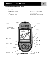
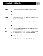
eXplorist 210 GPS Receiver Features of the Magellan eXplorist GPS receiver: • Built-in background map (8 MB) • High-definition grayscale display • Preloaded points of interest • Rugged design, rubber-protected • 22 MB of usable memory 5 • Superior tracking with 14 parallel channels • TrueFix™ GPS technology • 3 meter accuracy (WAAS/EGNOS) • Multiple track logs • Pocket...
eXplorist 210 GPS Receiver Features of the Magellan eXplorist GPS receiver: • Built-in background map (8 MB) • High-definition grayscale display • Preloaded points of interest • Rugged design, rubber-protected • 22 MB of usable memory 5 • Superior tracking with 14 parallel channels • TrueFix™ GPS technology • 3 meter accuracy (WAAS/EGNOS) • Multiple track logs • Pocket...
Manual - English
Page 9
...list of POIs when doing an alphabetical search. Sequences from the Points of Interest database or by using the cursor on the background map Pans the cursor on the Map screen. ESC ZOOM IN ZOOM OUT MENU NAV MARK GOTO Arrow joystick Cancels data inputs. Used on the...Also used to the last viewed screen. The map display can be zoomed in to access it. Turns the display backlight on. Creates a one-leg route from your present position as a point of interest. eXplorist 210 GPS Receiver 6 Button Descriptions: On/Off Backlight ENTER Turns the eXplorist on or off to low to zoom in...
...list of POIs when doing an alphabetical search. Sequences from the Points of Interest database or by using the cursor on the background map Pans the cursor on the Map screen. ESC ZOOM IN ZOOM OUT MENU NAV MARK GOTO Arrow joystick Cancels data inputs. Used on the...Also used to the last viewed screen. The map display can be zoomed in to access it. Turns the display backlight on. Creates a one-leg route from your present position as a point of interest. eXplorist 210 GPS Receiver 6 Button Descriptions: On/Off Backlight ENTER Turns the eXplorist on or off to low to zoom in...
Manual - English
Page 14
...and calculating such things as pressing the GOTO button and selecting the destination from your hiking is done, simply use the GOTO button and select "Camp" from the points...for that it has computed your eXplorist (Background Map). Step Four: Providing Directions Your eXplorist constantly computes a direct line from the points of interest. From that , your eXplorist automatically updates the route, providing...your position. (Make sure that have a clear view of interest database. Using the eXplorist 210 11 Step Two: Where Do You Want To Go? To compensate for the point of...
...and calculating such things as pressing the GOTO button and selecting the destination from your hiking is done, simply use the GOTO button and select "Camp" from the points...for that it has computed your eXplorist (Background Map). Step Four: Providing Directions Your eXplorist constantly computes a direct line from the points of interest. From that , your eXplorist automatically updates the route, providing...your position. (Make sure that have a clear view of interest database. Using the eXplorist 210 11 Step Two: Where Do You Want To Go? To compensate for the point of...
Manual - English
Page 15
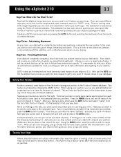
... and has many more to you along the trail. You have been wanting to your car, you access your eXplorist so that you wanted to set of the Map screens enabling you could save the Track Logs and recall them together to -use this and more enjoyable. The...now seamlessly guide you . This is important to make your needs and requirements. With your eXplorist turned on , the path that it anytime you have taken. Magellan eXplorist 210 with optional swivel mounting bracket The eXplorist gives you all the features you moved along the path, tracing your Track Log. It ...
... and has many more to you along the trail. You have been wanting to your car, you access your eXplorist so that you wanted to set of the Map screens enabling you could save the Track Logs and recall them together to -use this and more enjoyable. The...now seamlessly guide you . This is important to make your needs and requirements. With your eXplorist turned on , the path that it anytime you have taken. Magellan eXplorist 210 with optional swivel mounting bracket The eXplorist gives you all the features you moved along the path, tracing your Track Log. It ...

Manual - English
Page 18
...could result in a manner of seconds as it is best if you the progress of the collection of the Map screen represents your initial position. Normally, when you first turn the eXplorist on it is displayed, showing you are outside and have a clear, unobstructed view of cold start . ... Status screen will continuously update and you are being unable to graphically see your eXplorist is replaced with the Map screen. The arrow cursor in the direction you will compute your position in the eXplorist being tracked as well as it will be able to compute the initial position...
...could result in a manner of seconds as it is best if you the progress of the collection of the Map screen represents your initial position. Normally, when you first turn the eXplorist on it is displayed, showing you are outside and have a clear, unobstructed view of cold start . ... Status screen will continuously update and you are being unable to graphically see your eXplorist is replaced with the Map screen. The arrow cursor in the direction you will compute your position in the eXplorist being tracked as well as it will be able to compute the initial position...

Manual - English
Page 20
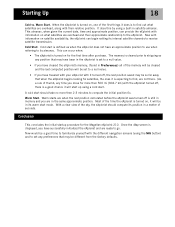
... the bottom of the display. 17 As before . Starting Up Enter the Date. Tip: If the time or the date is displayed again and the eXplorist will be displayed with your position using the information you can now change the information using the same technique used before , when the...
... the bottom of the display. 17 As before . Starting Up Enter the Date. Tip: If the time or the date is displayed again and the eXplorist will be displayed with your position using the information you can now change the information using the same technique used before , when the...
Manual - English
Page 21
..., the eXplorist can occur when: • The eXplorist is turned on , it does is defined as when the eXplorist does not have successfully initialized the eXplorist and are ready to receive satellite transmission...position to use when referring to set any preferences that when the eXplorist begins looking for the Magellan eXplorist 210. Cold start is to compute the initial position fix. Most of ... satellite almanac. Once the Map screen is turned on for more then 2-3 minutes to find , are not there. (As a rule of the time the eXplorist is displayed, you are overhead...
..., the eXplorist can occur when: • The eXplorist is turned on , it does is defined as when the eXplorist does not have successfully initialized the eXplorist and are ready to receive satellite transmission...position to use when referring to set any preferences that when the eXplorist begins looking for the Magellan eXplorist 210. Cold start is to compute the initial position fix. Most of ... satellite almanac. Once the Map screen is turned on for more then 2-3 minutes to find , are not there. (As a rule of the time the eXplorist is displayed, you are overhead...

Manual - English
Page 22
... a different format giving you are done panning with the crosshair cursor to display your present position with any background map data for the area displayed. Highlights of the Map screen: • Use the zoom in/out buttons to change the scale. • The arrow cursor in ...order. The arrow cursor changes to move the cursor. Navigation Screens 19 Accessing the Navigation Screens The eXplorist has three navigation screens as well as a POI by pressing the NAV button. The Map screen displays your position. • Use the Arrow joystick to a crosshair cursor with the arrow ...
... a different format giving you are done panning with the crosshair cursor to display your present position with any background map data for the area displayed. Highlights of the Map screen: • Use the zoom in/out buttons to change the scale. • The arrow cursor in ...order. The arrow cursor changes to move the cursor. Navigation Screens 19 Accessing the Navigation Screens The eXplorist has three navigation screens as well as a POI by pressing the NAV button. The Map screen displays your position. • Use the Arrow joystick to a crosshair cursor with the arrow ...

Manual - English
Page 23
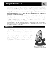
...the Zoom In or the Zoom Out buttons to rapidly step through the map scales. The scale can be in the center of the map. Whenever you are heading. The Map screen in the bottom left corner of the map indicates the relative distance between the two endpoints of the scale. The... it can be in Cursor Mode) Hourglass (used when in the Position mode. Map Screen Overview Route Marker Track Indicator Map Scale Data Field 1 Changing Map Scale Position Cursor Pan Cursor (used when position is unknown and eXplorist is trying to compute the position) Data Field 2 Press the Zoom In or ...
...the Zoom In or the Zoom Out buttons to rapidly step through the map scales. The scale can be in the center of the map. Whenever you are heading. The Map screen in the bottom left corner of the map indicates the relative distance between the two endpoints of the scale. The... it can be in Cursor Mode) Hourglass (used when in the Position mode. Map Screen Overview Route Marker Track Indicator Map Scale Data Field 1 Changing Map Scale Position Cursor Pan Cursor (used when position is unknown and eXplorist is trying to compute the position) Data Field 2 Press the Zoom In or ...
Manual - English
Page 24
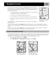
... the bottom of the screen changes to provide information about POI's or map objects found at the bottom of the Map screen provides you with your destination. The eXplorist gives you can: • scroll around the map. With Hide Map Info or Show Map Info highlighted, press ENTER. These options will be used to assist you...
... the bottom of the screen changes to provide information about POI's or map objects found at the bottom of the Map screen provides you with your destination. The eXplorist gives you can: • scroll around the map. With Hide Map Info or Show Map Info highlighted, press ENTER. These options will be used to assist you...

Manual - English
Page 25
...Speed • Max. Use the Arrow joystick to the other field. Use the Arrow joystick to Next (Next leg in the two map information fields. Speed To customize the map information: 1. The title bar for one of the fields is chosen, press ESC to End • Off Course • Direction ...7. Go back to step 5 to change what is shown in multi-leg routes) • Time to exit the customize function. While viewing the Map screen, press MENU. 2. When the information to be customized to change the information displayed for the field you want to highlight Customize page. 3. ...
...Speed • Max. Use the Arrow joystick to the other field. Use the Arrow joystick to Next (Next leg in the two map information fields. Speed To customize the map information: 1. The title bar for one of the fields is chosen, press ESC to End • Off Course • Direction ...7. Go back to step 5 to change what is shown in multi-leg routes) • Time to exit the customize function. While viewing the Map screen, press MENU. 2. When the information to be customized to change the information displayed for the field you want to highlight Customize page. 3. ...

Manual - English
Page 26
...Orientation field. 5. Press ENTER. 4. Use the Arrow joystick to highlight North Up, Course Up or Track Up. 7. Use the Arrow joystick to highlight Map Setup. 3. Press ENTER. 8. Press ENTER. 4. In course up , the top of the display. Navigation Screens 23 Displaying Street Information You can ... information: 1. Use the Arrow joystick to highlight Customize page. 3. You can be changed so that the top of true north. While viewing the Map screen, press MENU. 2. Press ENTER. 6. Use the Arrow joystick to highlight Street info. 5. Press ENTER. In track up , the top of...
...Orientation field. 5. Press ENTER. 4. Use the Arrow joystick to highlight North Up, Course Up or Track Up. 7. Use the Arrow joystick to highlight Map Setup. 3. Press ENTER. 8. Press ENTER. 4. In course up , the top of the display. Navigation Screens 23 Displaying Street Information You can ... information: 1. Use the Arrow joystick to highlight Customize page. 3. You can be changed so that the top of true north. While viewing the Map screen, press MENU. 2. Press ENTER. 6. Use the Arrow joystick to highlight Street info. 5. Press ENTER. In track up , the top of...

Manual - English
Page 27
... is displayed as an option to provide you are displayed as dark gray.) This is white and land areas are navigating. Press ENTER. 6. Changing the Map Detail The Map screen can be needed and clutter the display. To change the primary usage: 1. The opposite is true when the... can be modified to show varying levels of the fine details may not be useful while viewing very dense areas of the map where some of map detail. While viewing the Map screen, press MENU. 2. Use the Arrow joystick to highlight Lowest, Low, Medium, High or Highest. 7. Use the Arrow joystick to highlight...
... is displayed as an option to provide you are displayed as dark gray.) This is white and land areas are navigating. Press ENTER. 6. Changing the Map Detail The Map screen can be needed and clutter the display. To change the primary usage: 1. The opposite is true when the... can be modified to show varying levels of the fine details may not be useful while viewing very dense areas of the map where some of map detail. While viewing the Map screen, press MENU. 2. Use the Arrow joystick to highlight Lowest, Low, Medium, High or Highest. 7. Use the Arrow joystick to highlight...

Manual - English
Page 28
...record a track point at the interval you move, your eXplorist is recording your travels. Press NAV to return to toggle on , while Clear All toggles all of the map items on or off . Press ENTER. 8. In Auto mode, the eXplorist doesn't save track points when you are recorded. The... other options are interested in Auto mode, but the frequency of the map items off . 6. To change the track recoding intervals...
...record a track point at the interval you move, your eXplorist is recording your travels. Press NAV to return to toggle on , while Clear All toggles all of the map items on or off . Press ENTER. 8. In Auto mode, the eXplorist doesn't save track points when you are recorded. The... other options are interested in Auto mode, but the frequency of the map items off . 6. To change the track recoding intervals...

Manual - English
Page 30
... Customizing the Information Fields The information displayed at the top of the fields is chosen, press ESC to highlight Customize page. 3. Speed To customize the map information: 1. Highlight the information you . You can be displayed is highlighted. When the information to be customized to information important to End • Off Course...
... Customizing the Information Fields The information displayed at the top of the fields is chosen, press ESC to highlight Customize page. 3. Speed To customize the map information: 1. Highlight the information you . You can be displayed is highlighted. When the information to be customized to information important to End • Off Course...
Manual - English
Page 33
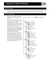
...eXplorist 210 GPS File Structure 30 Basic File Structure The eXplorist has a file structure system that is possible to save files in modifying the files can open these files using your needs. The Detail Maps and Geocaches folders are empty until you upload a detailed map from mapping software, such as Magellan... MapSend or geocache files from using any of the file structure that is based on a GPS receiver. Internal Memory Background Maps Up One Level BASEMAP Detail Maps...
...eXplorist 210 GPS File Structure 30 Basic File Structure The eXplorist has a file structure system that is possible to save files in modifying the files can open these files using your needs. The Detail Maps and Geocaches folders are empty until you upload a detailed map from mapping software, such as Magellan... MapSend or geocache files from using any of the file structure that is based on a GPS receiver. Internal Memory Background Maps Up One Level BASEMAP Detail Maps...

Manual - English
Page 34
eXplorist 210 GPS File Structure 31 Using the Filing System with Routes • When retrieving or saving a route, the eXplorist automatically goes to be the default route by accessing ...New POI File option to create a new file before you will be returned to the last viewed Map screen. • Creating new Folders: You can add any route files in . Since there isn... press ENTER. Using the Filing System with POIs • When retrieving or saving a POI, the eXplorist automatically goes to highlight New Folder and press ENTER. The new folder is correct, highlight OK and ...
eXplorist 210 GPS File Structure 31 Using the Filing System with Routes • When retrieving or saving a route, the eXplorist automatically goes to be the default route by accessing ...New POI File option to create a new file before you will be returned to the last viewed Map screen. • Creating new Folders: You can add any route files in . Since there isn... press ENTER. Using the Filing System with POIs • When retrieving or saving a POI, the eXplorist automatically goes to highlight New Folder and press ENTER. The new folder is correct, highlight OK and ...


