Manual - English
Page 2
... software supplied in and with the product. Never rely solely on the Magellan eXplorist while driving. USE GOOD JUDGEMENT This product is solely responsible for careful orienteering and good judgement. government and is operated by poor satellite geometry and obstructions, like any changes. the use of Defense civil GPS user policy and the Federal Radionavigation Plan. USE CARE The Global Positioning System (GPS...
... software supplied in and with the product. Never rely solely on the Magellan eXplorist while driving. USE GOOD JUDGEMENT This product is solely responsible for careful orienteering and good judgement. government and is operated by poor satellite geometry and obstructions, like any changes. the use of Defense civil GPS user policy and the Federal Radionavigation Plan. USE CARE The Global Positioning System (GPS...
Manual - English
Page 4
... Contents eXplorist 210 GPS Receiver Features of the Magellan eXplorist GPS receiver: Button Descriptions: Installing the Battery Using the eXplorist 210 Going to a Destination Saving Your Position Tracing Your Steps Additional Features Starting Up Turning the eXplorist On Turning the eXplorist Off Using the eXplorist for the First Time Turning the Display Backlight On/Off Conclusion Navigation Screens Accessing the Navigation Screens Map Screen Map Screen Overview Changing Map Scale Map Screen Modes Showing or Hiding Map Information Customizing the Map Information Changing the Map Orientation...
... Contents eXplorist 210 GPS Receiver Features of the Magellan eXplorist GPS receiver: Button Descriptions: Installing the Battery Using the eXplorist 210 Going to a Destination Saving Your Position Tracing Your Steps Additional Features Starting Up Turning the eXplorist On Turning the eXplorist Off Using the eXplorist for the First Time Turning the Display Backlight On/Off Conclusion Navigation Screens Accessing the Navigation Screens Map Screen Map Screen Overview Changing Map Scale Map Screen Modes Showing or Hiding Map Information Customizing the Map Information Changing the Map Orientation...

Manual - English
Page 5
...the Map Screen Showing or Hiding a User-Entered POI on the Map Screen Routes GOTO Routes Creating a GOTO Route from the Map Cursor Creating a GOTO Route Multi-Leg Routes Creating a GOTO Route to a Map Object Creating a Multi-leg Route Activating/Deactivating a Route Changing the Destination Leg of an Active Route Editing a Saved Route Deleting a Route Reversing a Route Copying a Route Moving a Route Viewing a Route on the Map Track Logs Track Logs Starting a New Active Track Log Stopping and Resuming Active Track Logging Saving an Active Track Log Clearing the Active Track Creating a BackTrack...
...the Map Screen Showing or Hiding a User-Entered POI on the Map Screen Routes GOTO Routes Creating a GOTO Route from the Map Cursor Creating a GOTO Route Multi-Leg Routes Creating a GOTO Route to a Map Object Creating a Multi-leg Route Activating/Deactivating a Route Changing the Destination Leg of an Active Route Editing a Saved Route Deleting a Route Reversing a Route Copying a Route Moving a Route Viewing a Route on the Map Track Logs Track Logs Starting a New Active Track Log Stopping and Resuming Active Track Logging Saving an Active Track Log Clearing the Active Track Creating a BackTrack...
Manual - English
Page 6
Overview of Uploading Detail Maps from MapSend to the eXplorist Transferring POIs, Routes, and Tracks to MapSend Transferring POIs, Routes, and Track Between MapSend and eXplorist Transferring Waypoints, Routes, and Tracks from MapSend Preferences Restarting the GPS Changing the Default Folders Using Active Setup Setting the Map Units Selecting Navigational Units of Measure Selecting the Background or Detail Map Selecting the Coordinate System Selecting the North Reference Using the Power Management Tool Setting the Power Off Timer Selecting the Map Datum 3 61 61 61 61 62 62 62 62 62 63...
Overview of Uploading Detail Maps from MapSend to the eXplorist Transferring POIs, Routes, and Tracks to MapSend Transferring POIs, Routes, and Track Between MapSend and eXplorist Transferring Waypoints, Routes, and Tracks from MapSend Preferences Restarting the GPS Changing the Default Folders Using Active Setup Setting the Map Units Selecting Navigational Units of Measure Selecting the Background or Detail Map Selecting the Coordinate System Selecting the North Reference Using the Power Management Tool Setting the Power Off Timer Selecting the Map Datum 3 61 61 61 61 62 62 62 62 62 63...
Manual - English
Page 7
Using the eXplorist with MapSend Personalizing the eXplorist Setting the Light Timer Clearing Memory Clearing All Track Logs Selecting Languages Clearing Routes Clearing Active Track , User-Entered POIs and Routes Clearing User-Entered POIs and Routes Setting Alarms Resetting the eXplorist to Factory Defaults Setting the Clock Setting the Time & Format Setting Daylight Savings Time Specifications Performance Physical Memory Coordinate Systems Routes Track Logs Power Navigation Screens Alarms Points of Interest Accessories Contacting Magellan Support Contacting Magellan Support Contacting ...
Using the eXplorist with MapSend Personalizing the eXplorist Setting the Light Timer Clearing Memory Clearing All Track Logs Selecting Languages Clearing Routes Clearing Active Track , User-Entered POIs and Routes Clearing User-Entered POIs and Routes Setting Alarms Resetting the eXplorist to Factory Defaults Setting the Clock Setting the Time & Format Setting Daylight Savings Time Specifications Performance Physical Memory Coordinate Systems Routes Track Logs Power Navigation Screens Alarms Points of Interest Accessories Contacting Magellan Support Contacting Magellan Support Contacting ...
Manual - English
Page 9
... save your present position to a destination selected from off . Turns the display backlight on. The map display can be zoomed in the My Points of Interest portion of POIs when doing an alphabetical search. Also used to quickly step through the navigation screens. Options can be selected by using the arrow joystick to highlight the option and pressing ENTER to access it. eXplorist 210 GPS Receiver 6 Button Descriptions: On/Off Backlight ENTER Turns the eXplorist...
... save your present position to a destination selected from off . Turns the display backlight on. The map display can be zoomed in the My Points of Interest portion of POIs when doing an alphabetical search. Also used to quickly step through the navigation screens. Options can be selected by using the arrow joystick to highlight the option and pressing ENTER to access it. eXplorist 210 GPS Receiver 6 Button Descriptions: On/Off Backlight ENTER Turns the eXplorist...
Manual - English
Page 14
... your eXplorist and after it . Press the MARK button and set up -to save your eXplorist (Background Map). Turn on a large body of water, it from your present position to any time, is as simple as heading and speed. This time you can do just that you can enter the name "Catfish1" and save it has computed your position, press the MARK button to -date information about any point of...
... your eXplorist and after it . Press the MARK button and set up -to save your eXplorist (Background Map). Turn on a large body of water, it from your present position to any time, is as simple as heading and speed. This time you can do just that you can enter the name "Catfish1" and save it has computed your position, press the MARK button to -date information about any point of...
Manual - English
Page 15
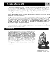
... press MENU, highlight BackTrack and press ENTER. Another nice feature of the Map screens enabling you started. The eXplorist makes full use , portable navigation tool that includes built-in odometer so you may find useful, is a built-in help files that you access your travels. Magellan eXplorist 210 with optional swivel mounting bracket There is that it 's time to head back to your car, you can save the Track...
... press MENU, highlight BackTrack and press ENTER. Another nice feature of the Map screens enabling you started. The eXplorist makes full use , portable navigation tool that includes built-in odometer so you may find useful, is a built-in help files that you access your travels. Magellan eXplorist 210 with optional swivel mounting bracket There is that it 's time to head back to your car, you can save the Track...
Manual - English
Page 21
... the eXplorist turned off , the last position saved may be in Preferences) all of the first things it will start up using a cold start mode. Once the Map screen is still in memory and you have an approximate position to use when referring to the eXplorist. Most of the time the eXplorist is defined as when the eXplorist does not have traveled with your eXplorist with the different navigation screens (using a built...
... the eXplorist turned off , the last position saved may be in Preferences) all of the first things it will start up using a cold start mode. Once the Map screen is still in memory and you have an approximate position to use when referring to the eXplorist. Most of the time the eXplorist is defined as when the eXplorist does not have traveled with your eXplorist with the different navigation screens (using a built...

Manual - English
Page 23
... only displays your position, indicated by the arrow icon in Cursor Mode) Hourglass (used when in the center of the map is the default mode for the Map screen. Whenever you are heading. The map scale indicator in the Position mode. Navigation Screens 20 • Press MENU and select Customize page to change the information displayed at the bottom of the screen. • Press MENU and select Map Setup to change how much of the map. The Position mode is displayed...
... only displays your position, indicated by the arrow icon in Cursor Mode) Hourglass (used when in the center of the map is the default mode for the Map screen. Whenever you are heading. The map scale indicator in the Position mode. Navigation Screens 20 • Press MENU and select Customize page to change the information displayed at the bottom of the screen. • Press MENU and select Map Setup to change how much of the map. The Position mode is displayed...
Manual - English
Page 24
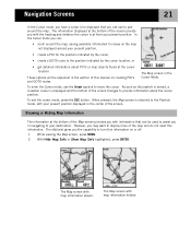
... of this information on creating POI's and GOTO routes. The Map screen in the Cursor Mode. With Hide Map Info or Show Map Info highlighted, press ENTER. These options will be used to assist you in navigating to provide information about POI's or map objects found at the cursor location. To exit the cursor mode, press the ESC button. Navigation Screens 21 In the Cursor mode, you have a cursor icon displayed that...
... of this information on creating POI's and GOTO routes. The Map screen in the Cursor Mode. With Hide Map Info or Show Map Info highlighted, press ENTER. These options will be used to assist you in navigating to provide information about POI's or map objects found at the cursor location. To exit the cursor mode, press the ESC button. Navigation Screens 21 In the Cursor mode, you have a cursor icon displayed that...

Manual - English
Page 28
... ENTER. Navigation Screens 25 Changing the Track Recording Intervals As you move, your eXplorist is suitable for most applications. In Detailed Auto mode, the eXplorist does the same as you have the desired settings. Press ENTER. 4. When an item has a check mark next to toggle on , while Clear All toggles all of track points saved is increased, especially during turns. This instructs your travels. While this uses more memory, it will be displayed...
... ENTER. Navigation Screens 25 Changing the Track Recording Intervals As you move, your eXplorist is suitable for most applications. In Detailed Auto mode, the eXplorist does the same as you have the desired settings. Press ENTER. 4. When an item has a check mark next to toggle on , while Clear All toggles all of track points saved is increased, especially during turns. This instructs your travels. While this uses more memory, it will be displayed...
Manual - English
Page 33
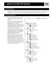
... upload a detailed map from mapping software, such as Magellan MapSend or geocache files from using any text editor and modify them to your needs. It is internal to the eXplorist. Internal Memory Background Maps Up One Level BASEMAP Detail Maps Up One Level Empty My POIs Up One Level New Folder New POI File Default POI File Routes Up One Level New Folder New Route File Default Route File Track Logs Up One Level New Folder Active Track Geocaches Up One Level New Folder Empty
... upload a detailed map from mapping software, such as Magellan MapSend or geocache files from using any text editor and modify them to your needs. It is internal to the eXplorist. Internal Memory Background Maps Up One Level BASEMAP Detail Maps Up One Level Empty My POIs Up One Level New Folder New POI File Default POI File Routes Up One Level New Folder New Route File Default Route File Track Logs Up One Level New Folder Active Track Geocaches Up One Level New Folder Empty

Manual - English
Page 44
... POI to be deleted) it just copies it to change. 13. When you want to the My Points of Interest portion of the database. 1. Press ENTER. 7. [Only if Alphabetical selected] Use the Arrow joystick and the ENTER button to highlight Background Map. 5. Steps 12 through 14 are done, use the Arrow joystick to 20 characters long (including spaces). 14c. Press MENU. 2. Use the Arrow...
... POI to be deleted) it just copies it to change. 13. When you want to the My Points of Interest portion of the database. 1. Press ENTER. 7. [Only if Alphabetical selected] Use the Arrow joystick and the ENTER button to highlight Background Map. 5. Steps 12 through 14 are done, use the Arrow joystick to 20 characters long (including spaces). 14c. Press MENU. 2. Use the Arrow...
Manual - English
Page 76
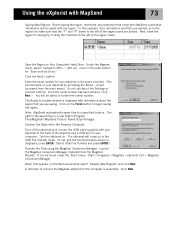
... press ENTER.) Transfer the Files using the Magellan Conversion Manager: Launch the Magellan Conversion Manager (installed from the main menu). Next, mark the region for your eXplorist by clicking the checkbox to GPS..." (Ctrl+U). This can be found on Hard Drive." Using the eXplorist with MapSend to set what information will be asked to begin saving the region. Click the Next > button. Enter the serial number for saving by accessing the About... screen...
... press ENTER.) Transfer the Files using the Magellan Conversion Manager: Launch the Magellan Conversion Manager (installed from the main menu). Next, mark the region for your eXplorist by clicking the checkbox to GPS..." (Ctrl+U). This can be found on Hard Drive." Using the eXplorist with MapSend to set what information will be asked to begin saving the region. Click the Next > button. Enter the serial number for saving by accessing the About... screen...
Manual - English
Page 78
... USB cable to conclude the transfer. 13. Click on . 6. A progress bar is displayed and will indicate when the transfer has completed. 12. Turn the eXplorist on the active folder icon. Select 'Convert to MapSend' (sending data points from the eXplorist to MapSend). In the example shown, files are being transferred from the eXplorist to MapSend. 9. Using the eXplorist with your eXplorist.) Transferring POIs, Routes, and Tracks to and from File...". Click the Next > button...
... USB cable to conclude the transfer. 13. Click on . 6. A progress bar is displayed and will indicate when the transfer has completed. 12. Turn the eXplorist on the active folder icon. Select 'Convert to MapSend' (sending data points from the eXplorist to MapSend). In the example shown, files are being transferred from the eXplorist to MapSend. 9. Using the eXplorist with your eXplorist.) Transferring POIs, Routes, and Tracks to and from File...". Click the Next > button...
Manual - English
Page 79
... by using the Start button on the Magellan Conversion Manager. 10. Under "Programs" select 'Magellan > eXplorist 210 > Magellan Conversion Manager'. 6. Press ENTER. The next time you access My Points of the MapSend display to select the file that was just uploaded. Click the Place Waypoint icon at the top of Interest, you will be able to bring up the Waypoint List. 3. From the Waypoint Menu, select 'Save to conclude the transfer. 16. Select 'Convert to eXplorist' (sending data points...
... by using the Start button on the Magellan Conversion Manager. 10. Under "Programs" select 'Magellan > eXplorist 210 > Magellan Conversion Manager'. 6. Press ENTER. The next time you access My Points of the MapSend display to select the file that was just uploaded. Click the Place Waypoint icon at the top of Interest, you will be able to bring up the Waypoint List. 3. From the Waypoint Menu, select 'Save to conclude the transfer. 16. Select 'Convert to eXplorist' (sending data points...

Manual - English
Page 80
... information displayed. • A means to set alarms to "look -up" in view. Many eXplorist users will be used to display information. • Access to tools that it thinks are getting near your position but it assumes that will provide you with its approximate location if it has been moved a large distance while turned off , and begin looking for position information and the map datum used to assist in prolonging battery...
... information displayed. • A means to set alarms to "look -up" in view. Many eXplorist users will be used to display information. • Access to tools that it thinks are getting near your position but it assumes that will provide you with its approximate location if it has been moved a large distance while turned off , and begin looking for position information and the map datum used to assist in prolonging battery...

Manual - English
Page 83
... highlight the field that you are accessing. Changing the Default Folders You can use . Press ENTER. 6. These default locations may not meet your data. Use the Arrow joystick to change these defaults to more meet your requirements as the default. Note: Selecting File Off turns the default file off . 9. Background maps cannot be taken to the top level folder for the particular kind of Preferences to change . 7. If you selected Select File, using the...
... highlight the field that you are accessing. Changing the Default Folders You can use . Press ENTER. 6. These default locations may not meet your data. Use the Arrow joystick to change these defaults to more meet your requirements as the default. Note: Selecting File Off turns the default file off . 9. Background maps cannot be taken to the top level folder for the particular kind of Preferences to change . 7. If you selected Select File, using the...
User Manual
Page 4
... also fit in the software serial number for any consumer electronics retailer. When you will see this dialog box: Disregard the "Settings" and "Connect" options. You will see this section. Next you have used MapSend to eXplorist internal memory, but with maps Before you get started, you may want to purchase an SD memory card from any other compatible Magellan GPS receivers. limited only by...
... also fit in the software serial number for any consumer electronics retailer. When you will see this dialog box: Disregard the "Settings" and "Connect" options. You will see this section. Next you have used MapSend to eXplorist internal memory, but with maps Before you get started, you may want to purchase an SD memory card from any other compatible Magellan GPS receivers. limited only by...


