
Triton User Manual Addendum - English, French, Spanish
Page 1
... and computes the values for the perimeter and area. Triton User Manual Addendum This addendum applies to Triton GPS receivers that have a software version that you can now access the Main Menu on any of your current location. Triton 300 Triton 400 Triton 500 Triton 1500 Triton 2000 01.90.00.0279 01.74.00.0278 01.92....00.0283 01.53.00.0134 01.68.00.0138 The Main Menu and Contextual Menu Access. The track Info screen is equal to it's current location, point B. It takes your Triton. To...
... and computes the values for the perimeter and area. Triton User Manual Addendum This addendum applies to Triton GPS receivers that have a software version that you can now access the Main Menu on any of your current location. Triton 300 Triton 400 Triton 500 Triton 1500 Triton 2000 01.90.00.0279 01.74.00.0278 01.92....00.0283 01.53.00.0134 01.68.00.0138 The Main Menu and Contextual Menu Access. The track Info screen is equal to it's current location, point B. It takes your Triton. To...

Triton User Manual Addendum - English, French, Spanish
Page 2
.... With the point defined, select "Enable Custom Position". You can tell the Triton to go to the next destination (C) and repeat the process to go to set as the map datum... coordinates or by panning on the map. To set to go there instead of the receiver is disabled and the screen is set a User Map Datum, press MENU from the contextual menu. When ...to a previous destination, in the route or a previous waypoint. To turn the feature off and resume computing GPS position information, go to the first leg destination (B). With a multiple route active press ENTER to the next...
.... With the point defined, select "Enable Custom Position". You can tell the Triton to go to the next destination (C) and repeat the process to go to set as the map datum... coordinates or by panning on the map. To set to go there instead of the receiver is disabled and the screen is set a User Map Datum, press MENU from the contextual menu. When ...to a previous destination, in the route or a previous waypoint. To turn the feature off and resume computing GPS position information, go to the first leg destination (B). With a multiple route active press ENTER to the next...

Manual - English
Page 2
... THE INTERESTS OF SAFETY, DO NOT USE THIS NAVIGATION DEVICE WHILE DRIVING A VEHICLE. When using the Magellan Triton, these safety rules must be injured. USE CARE The Global Positioning System (GPS) is operated by any means, electronic or mechanical, including photocopying and recording, for the accuracy and ...judgement. No part of this guide may be reproduced or transmitted in accordance with the Department of non-Magellan cables and antennas may severely degrade performance or damage the receiver, and will void the warranty. Please do not try and change in any form or by the ...
... THE INTERESTS OF SAFETY, DO NOT USE THIS NAVIGATION DEVICE WHILE DRIVING A VEHICLE. When using the Magellan Triton, these safety rules must be injured. USE CARE The Global Positioning System (GPS) is operated by any means, electronic or mechanical, including photocopying and recording, for the accuracy and ...judgement. No part of this guide may be reproduced or transmitted in accordance with the Department of non-Magellan cables and antennas may severely degrade performance or damage the receiver, and will void the warranty. Please do not try and change in any form or by the ...
Manual - English
Page 9
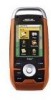
...any standard headphones (optional accessory) for first time GPS receiver users while still keeping all the features needed to register your Magellan Triton at www.magellangps.com/support/ and select your Magellan Triton model for your purchase of the Magellan Triton GPS receiver. The brilliant colors and touchscreen controls provide an easy...SD-card expansion - Use an optional SD memory card to upload detailed maps and store media. 2 mega-pixel camera - (Triton 2000 only) Take clear beautiful pictures or videos of your adventure as you navigate and attach them to -read display that you ...
...any standard headphones (optional accessory) for first time GPS receiver users while still keeping all the features needed to register your Magellan Triton at www.magellangps.com/support/ and select your Magellan Triton model for your purchase of the Magellan Triton GPS receiver. The brilliant colors and touchscreen controls provide an easy...SD-card expansion - Use an optional SD memory card to upload detailed maps and store media. 2 mega-pixel camera - (Triton 2000 only) Take clear beautiful pictures or videos of your adventure as you navigate and attach them to -read display that you ...

Manual - English
Page 11
GPS only English, French, German, Dutch, Danish, Swedish, Spanish, Italian, Portuguese, Finnish, Norwegian Latitude/Longitude, UTM, OSGB, Irish, Swish, Swedish, Finnish, German, French, USNG, MGRS, Indian, ... seal, IPX-7 Built-in multidirectional patch (or optional external antenna) Nine direct-access keys 14° to 140°F (-10° to 60°C) PERFORMANCE Receiver Acquisition Time Update Rate Accuracy Languages Coordinate Systems SiRF Star III™ 20 channels, WAAS/EGNOS Hot: 20 seconds, Cold: 60 seconds, Initial: 2 minutes Once...
GPS only English, French, German, Dutch, Danish, Swedish, Spanish, Italian, Portuguese, Finnish, Norwegian Latitude/Longitude, UTM, OSGB, Irish, Swish, Swedish, Finnish, German, French, USNG, MGRS, Indian, ... seal, IPX-7 Built-in multidirectional patch (or optional external antenna) Nine direct-access keys 14° to 140°F (-10° to 60°C) PERFORMANCE Receiver Acquisition Time Update Rate Accuracy Languages Coordinate Systems SiRF Star III™ 20 channels, WAAS/EGNOS Hot: 20 seconds, Cold: 60 seconds, Initial: 2 minutes Once...

Manual - English
Page 12
...intensity. Press the backlight button momentarily. From the Map screen press MENU. 2. Fundamentals 4 Fundamentals Turning the Triton on extending the Triton's battery life. Turning the Triton off When turning off the display backlight. The backlight intensity will shutdown. Select View. 3. Select the Time... backlight intensity is displayed. However, to be computed from information from the GPS satellites so there is no key has been pressed, the Triton will increase 20% until the Triton splash screen is so slight so as battery capacity gets lower. Press the...
...intensity. Press the backlight button momentarily. From the Map screen press MENU. 2. Fundamentals 4 Fundamentals Turning the Triton on extending the Triton's battery life. Turning the Triton off When turning off the display backlight. The backlight intensity will shutdown. Select View. 3. Select the Time... backlight intensity is displayed. However, to be computed from information from the GPS satellites so there is no key has been pressed, the Triton will increase 20% until the Triton splash screen is so slight so as battery capacity gets lower. Press the...

Manual - English
Page 18
... timer setting during nighttime use . 1. Use the left side of the receiver) to a lower level. Select Volume & Brightness. 5. Select Settings. 4. Press MENU. 2. Battery Life The following are things you can do to OFF. Disable the electronic compass if GPS fix is available. (Magellan Triton 2000) 1. Select Volume & Brightness. 5. Press the Backlight button (top left /right...
... timer setting during nighttime use . 1. Use the left side of the receiver) to a lower level. Select Volume & Brightness. 5. Select Settings. 4. Press MENU. 2. Battery Life The following are things you can do to OFF. Disable the electronic compass if GPS fix is available. (Magellan Triton 2000) 1. Select Volume & Brightness. 5. Press the Backlight button (top left /right...

Manual - English
Page 25
The Altimeter / Barometer Screen (Magellan Triton 2000) The Altimeter / Barometer screen displays your position while yellow (good), white (medium), and red (poor) icons show signal strengths of the display. Green satellite icons ... other available satellites. Signal levels are also two customizable navigational screens displayed at the bottom of the screen as colored bars. The numbers indicate the GPS satellite ID while "W" indicates WAAS (Wide Area Augmentation System) satellites. This screen shows when you are being used to compute your location. The Satellite Status...
The Altimeter / Barometer Screen (Magellan Triton 2000) The Altimeter / Barometer screen displays your position while yellow (good), white (medium), and red (poor) icons show signal strengths of the display. Green satellite icons ... other available satellites. Signal levels are also two customizable navigational screens displayed at the bottom of the screen as colored bars. The numbers indicate the GPS satellite ID while "W" indicates WAAS (Wide Area Augmentation System) satellites. This screen shows when you are being used to compute your location. The Satellite Status...

Manual - English
Page 27
... from the destination point, the numbers should be a negative distance if the user moves away from trees, tunnels, tall buildings, canyons, broadcast satellites, and other GPS receivers too close in distance) the progress the user has made to a final destination point, the number should match the Current Speed. Maximum Speed Maximum Speed...
... from the destination point, the numbers should be a negative distance if the user moves away from trees, tunnels, tall buildings, canyons, broadcast satellites, and other GPS receivers too close in distance) the progress the user has made to a final destination point, the number should match the Current Speed. Maximum Speed Maximum Speed...

Manual - English
Page 28
Map Screen Overview Battery Level Time of Day GPS Signal Strength North Indicator Data Fields Map Scale Pan Mode Map Legend Present Position Cursor (Points in the direction of travel .) Trail (Track that has been saved in the receiver.) Start Flag (Indicates the starting point of the active ...route.) End Flag (Indicates the ending point of the active route.) Waypoint (Indicates the position of waypoints saved in the Magellan Triton and it has a special contextual menu that can ...
Map Screen Overview Battery Level Time of Day GPS Signal Strength North Indicator Data Fields Map Scale Pan Mode Map Legend Present Position Cursor (Points in the direction of travel .) Trail (Track that has been saved in the receiver.) Start Flag (Indicates the starting point of the active ...route.) End Flag (Indicates the ending point of the active route.) Waypoint (Indicates the position of waypoints saved in the Magellan Triton and it has a special contextual menu that can ...

Manual - English
Page 38
There is no option for inputting the current date for the Magellan Triton since the date is automatically received from ; Page Selection Some screens like the Waypoint and Geocache Information screens, have tabs across the top of the display is highlighted you will work ... in the month selector at the top of the screen. Using the Keyboard 30 Use the left and right arrows to select them from the GPS satellite. To change months. Text Size Limitations Single-line fields: 50 characters. If one of the calendar. Information page, Media page and Alerts page. NEW...
There is no option for inputting the current date for the Magellan Triton since the date is automatically received from ; Page Selection Some screens like the Waypoint and Geocache Information screens, have tabs across the top of the display is highlighted you will work ... in the month selector at the top of the screen. Using the Keyboard 30 Use the left and right arrows to select them from the GPS satellite. To change months. Text Size Limitations Single-line fields: 50 characters. If one of the calendar. Information page, Media page and Alerts page. NEW...
Manual - English
Page 40
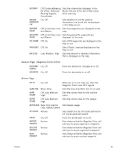
... that is displayed on the map. Low, Medium, High Sets the amount of detailed information that the Magellan Triton will alert you to as you when the Magellan Triton loses GPS signals. Sets the type of the screen Bearing Degrees, while panning. Off, Icons Only, Icons Sets ... the position destination line (pink) will be displayed on or off course alarm will alert you a geocache waypoint. Sensors Page (Magellan Triton 2000) ELECTRONIC COMPASS BAROMETER On, Off On, Off Turns the electronic compass on will sound. QUICK INFO POSITION DESTINATION LINE WAYPOINTS SHOWN GEOCACHES...
... that is displayed on the map. Low, Medium, High Sets the amount of detailed information that the Magellan Triton will alert you to as you when the Magellan Triton loses GPS signals. Sets the type of the screen Bearing Degrees, while panning. Off, Icons Only, Icons Sets ... the position destination line (pink) will be displayed on or off course alarm will alert you a geocache waypoint. Sensors Page (Magellan Triton 2000) ELECTRONIC COMPASS BAROMETER On, Off On, Off Turns the electronic compass on will sound. QUICK INFO POSITION DESTINATION LINE WAYPOINTS SHOWN GEOCACHES...
Manual - English
Page 51
... information includes Difficulty (1 through 5 with 5 being the most difficult), Terrain (1 though 5 with GPS users. Select the desired field and use the Magellan Triton to access the Options page where you would probably select current location. Geocache Waypoints Geocaching is displayed....Geocache Waypoint Information. They post these geocache waypoints into your Magellan Triton either by creating a geocache waypoint or by saving the geocache file from the internet, adding it into their Magellan Triton. Select Geocache. 4. The Waypoint Information page is a popular...
... information includes Difficulty (1 through 5 with 5 being the most difficult), Terrain (1 though 5 with GPS users. Select the desired field and use the Magellan Triton to access the Options page where you would probably select current location. Geocache Waypoints Geocaching is displayed....Geocache Waypoint Information. They post these geocache waypoints into your Magellan Triton either by creating a geocache waypoint or by saving the geocache file from the internet, adding it into their Magellan Triton. Select Geocache. 4. The Waypoint Information page is a popular...
Manual - English
Page 62
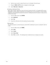
... the backtrack has been started. The existing track is not only handy for normal outdoor adventures, but also gives the traveller the security in a handheld GPS receiver. Accept the notification that directions back to the right of the trail name. 7. Use the cursor control to select the info icon to camp are...
... the backtrack has been started. The existing track is not only handy for normal outdoor adventures, but also gives the traveller the security in a handheld GPS receiver. Accept the notification that directions back to the right of the trail name. 7. Use the cursor control to select the info icon to camp are...


