
Owner's Manual
Page 4
... Cautions 3 FCC Compliance Statement 4 Features 5 Buttons 6 Description 7 Accessories 8 Installing the Batteries 8 Getting Started 9-17 Satellite Page Basics 10 Map Page Basics 11 Navigation Page Basics 12 Main Menu Page Basics 13 Creating a Waypoint 14 Heading in the Right Direction 16 Cancelling a...Waypoint Page 23 Routes 25 Tracks 28 Setup Menu 31 Appendices 40-51 Appendix A: Specifications 40 Appendix B: What is GPS 41 Appendix C: Satellite Reception Tips 42 Appendix D: Time Offset Chart 44 Appendix E: Wiring Diagram 45 Appendix F: Troubleshooting 46 Appendix...
... Cautions 3 FCC Compliance Statement 4 Features 5 Buttons 6 Description 7 Accessories 8 Installing the Batteries 8 Getting Started 9-17 Satellite Page Basics 10 Map Page Basics 11 Navigation Page Basics 12 Main Menu Page Basics 13 Creating a Waypoint 14 Heading in the Right Direction 16 Cancelling a...Waypoint Page 23 Routes 25 Tracks 28 Setup Menu 31 Appendices 40-51 Appendix A: Specifications 40 Appendix B: What is GPS 41 Appendix C: Satellite Reception Tips 42 Appendix D: Time Offset Chart 44 Appendix E: Wiring Diagram 45 Appendix F: Troubleshooting 46 Appendix...
Owner's Manual
Page 7
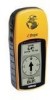
...location, the eTrex creates, names and saves a location (as an electronic waypoint) in battery save mode. Automatic track log; 10 saved tracks let you want. From these basic features, your path in GPS antenna and five user-buttons. It is a six ounce, 12 channel, hand held GPS receiver. It has... its memory, allowing you to navigate back to this point any time you retrace your Garmin GPS can concentrate on the sides of the unit, allowing for simple, one more . Introduction The eTrex is designed to augment other data, like speed, direction of movement, time and distance ...
...location, the eTrex creates, names and saves a location (as an electronic waypoint) in battery save mode. Automatic track log; 10 saved tracks let you want. From these basic features, your path in GPS antenna and five user-buttons. It is a six ounce, 12 channel, hand held GPS receiver. It has... its memory, allowing you to navigate back to this point any time you retrace your Garmin GPS can concentrate on the sides of the unit, allowing for simple, one more . Introduction The eTrex is designed to augment other data, like speed, direction of movement, time and distance ...
Owner's Manual
Page 12
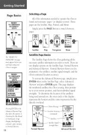
... Button to switch between pages. The "READY TO NAVIGATE" message must appear before you can begin using , their proximity to your eTrex to navigate. To determine the location of the satellites being used around you (in order to work. To activate the Advanced Skyview ... Sky Ahead or Northward, Setup Display (backlighting/ contrast), and returning to Normal Skyview. 10 PAGE PAGE PAGE PAGE Satellite Map Navigation Menu Satellite Page Basics The Satellite Page shows the eTrex gathering all the necessary satellite information in animation), the satellites, satellite signal strength, and...
... Button to switch between pages. The "READY TO NAVIGATE" message must appear before you can begin using , their proximity to your eTrex to navigate. To determine the location of the satellites being used around you (in order to work. To activate the Advanced Skyview ... Sky Ahead or Northward, Setup Display (backlighting/ contrast), and returning to Normal Skyview. 10 PAGE PAGE PAGE PAGE Satellite Map Navigation Menu Satellite Page Basics The Satellite Page shows the eTrex gathering all the necessary satellite information in animation), the satellites, satellite signal strength, and...

Owner's Manual
Page 46
...hour for daylight savings would be : EST: -5 EDT: -4 CST: -6 CDT: -5 MST: -7 MDT: -6 PST: -8 PDT: -7 44 would be -5. Offset -12 -11 -10 -9 -8 -7 -6 -5 -4 -3 -2 -1 -0 Longitudinal Zone E007.5° to E022.5° E022.5° to E037.5° E037.5° to E052.5° E052.5° to E067.5°....5° E142.5° to E157.5° E157.5° to E172.5° E172.5° to E180.0° Offset +1 +2 +3 +4 +5 +6 +7 +8 +9 +10 +11 +12 A simple way to determine your local time offset is 5 hours behind or ahead of UTC (also called 'Greenwich' or 'zulu' time) Example:...
...hour for daylight savings would be : EST: -5 EDT: -4 CST: -6 CDT: -5 MST: -7 MDT: -6 PST: -8 PDT: -7 44 would be -5. Offset -12 -11 -10 -9 -8 -7 -6 -5 -4 -3 -2 -1 -0 Longitudinal Zone E007.5° to E022.5° E022.5° to E037.5° E037.5° to E052.5° E052.5° to E067.5°....5° E142.5° to E157.5° E157.5° to E172.5° E172.5° to E180.0° Offset +1 +2 +3 +4 +5 +6 +7 +8 +9 +10 +11 +12 A simple way to determine your local time offset is 5 hours behind or ahead of UTC (also called 'Greenwich' or 'zulu' time) Example:...
Owner's Manual
Page 48
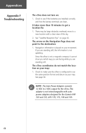
... facing while you are clean. This adapter is not interchangeable with a clear view of the sky. 2. Since the eTrex is based on your map. It takes more than 10 minutes to the destination: 1. There may be large obstacles overhead; move to use the same position format and datum... updating. The eTrex coordinates do not match the location on page 42. Appendices Appendix F Troubleshooting The eTrex does not turn on the Navigation Page does not point to get a location fix: 1. If you are standing still. Check to 3 VDC output for the Garmin VHF 720 and 725, GPS 170, 175,...
... facing while you are clean. This adapter is not interchangeable with a clear view of the sky. 2. Since the eTrex is based on your map. It takes more than 10 minutes to the destination: 1. There may be large obstacles overhead; move to use the same position format and datum... updating. The eTrex coordinates do not match the location on page 42. Appendices Appendix F Troubleshooting The eTrex does not turn on the Navigation Page does not point to get a location fix: 1. If you are standing still. Check to 3 VDC output for the Garmin VHF 720 and 725, GPS 170, 175,...

Owner's Manual
Page 52
... 8, 36 Maps 33 Marine Autopilot 45 Mark a Waypoint 14 Mark Waypoint Page 20-21 Max Speed 19 Menu Page Basics 13 Military Time 31 N Navigation 10, 12, 14 Navigation Page 12, 16, 19-20 Nearest Waypoints Page 22 NMEA 37, 45 North Reference 36 P Page Basics...
... 8, 36 Maps 33 Marine Autopilot 45 Mark a Waypoint 14 Mark Waypoint Page 20-21 Max Speed 19 Menu Page Basics 13 Military Time 31 N Navigation 10, 12, 14 Navigation Page 12, 16, 19-20 Nearest Waypoints Page 22 NMEA 37, 45 North Reference 36 P Page Basics...
Owner's Manual
Page 53
S Satellite Page 9, 10 Satellite Reception 10, 42-43 Setup Menu 31-39 Signal Strength Bar 10 Software Version 38 Specifications 40 Speed 19 Stop Navigation 18, 19 System Page 38-39 T Time Format 31 Time Offset Chart 44 Time Zones 13, 44 Tracback Navigation 30-31 Track Logs 17, 28-30, 48 Trip Odometer 20 Troubleshooting 46 U Units of Measure 35 Units Page 33-36 User Grid Format 34 UTC 32 W Warnings and Cautions 3 Warranty 52 Waypoints Page 22 Waypoint Symbol 14 Web Site 1 Welcome Page 9 Wiring Diagram 45 Appendices Appendix H Index 51
S Satellite Page 9, 10 Satellite Reception 10, 42-43 Setup Menu 31-39 Signal Strength Bar 10 Software Version 38 Specifications 40 Speed 19 Stop Navigation 18, 19 System Page 38-39 T Time Format 31 Time Offset Chart 44 Time Zones 13, 44 Tracback Navigation 30-31 Track Logs 17, 28-30, 48 Trip Odometer 20 Troubleshooting 46 U Units of Measure 35 Units Page 33-36 User Grid Format 34 UTC 32 W Warnings and Cautions 3 Warranty 52 Waypoints Page 22 Waypoint Symbol 14 Web Site 1 Welcome Page 9 Wiring Diagram 45 Appendices Appendix H Index 51
Quick Start Guide
Page 2
... it . Press the UP button to highlight 'YES.' Press the DOWN button to highlight 'CLEAR.' www.garmin.com eTrex / eTrex Camo QUICK START GUIDE Step-by clearing the track log (the lines left , go right. With 'OK..., you the direction to the POINTER Page. Press the PAGE button to switch to the new waypoint. or its subsidiaries Garmin International, Inc. 1200 E. 151st St., Olathe, KS 66062 USA Part Number 190-00395-01 Rev. To start a...a Waypoint Waypoints are locations that waypoint appears. 3. You're on target! 10 Stopping a GOTO To stop a GOTO: 1.
... it . Press the UP button to highlight 'YES.' Press the DOWN button to highlight 'CLEAR.' www.garmin.com eTrex / eTrex Camo QUICK START GUIDE Step-by clearing the track log (the lines left , go right. With 'OK..., you the direction to the POINTER Page. Press the PAGE button to switch to the new waypoint. or its subsidiaries Garmin International, Inc. 1200 E. 151st St., Olathe, KS 66062 USA Part Number 190-00395-01 Rev. To start a...a Waypoint Waypoints are locations that waypoint appears. 3. You're on target! 10 Stopping a GOTO To stop a GOTO: 1.


