Owner's Manual
Page 5
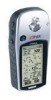
Introduction WARNING: For use in vehicles, it is the sole responsibility of the owner/operator of the eTrex Vista to secure the GPS unit so that can propel objects in their path toward the driver or passengers causing possible injury. Refer to operate the controls of ... Where Driver's Field of Vision is not warranted against collision damage or the consequences thereof. Do not mount the eTrex Vista in a safe manner, maintain full surveillance of all driving conditions at http://www.garmin. If you are likely to our web site at all times, and not become distracted by...
Introduction WARNING: For use in vehicles, it is the sole responsibility of the owner/operator of the eTrex Vista to secure the GPS unit so that can propel objects in their path toward the driver or passengers causing possible injury. Refer to operate the controls of ... Where Driver's Field of Vision is not warranted against collision damage or the consequences thereof. Do not mount the eTrex Vista in a safe manner, maintain full surveillance of all driving conditions at http://www.garmin. If you are likely to our web site at all times, and not become distracted by...
Owner's Manual
Page 6
... laws and international copyright trea- GARMIN grants you a limited license to use a combination of governmental and private data sources, which is solely responsible for its accuracy and maintenance. Software License Agreement BY USING THE ETREX VISTA, YOU AGREE TO BE BOUND ...NAVigation AID (NAVAID), any NAVAID can be misused or misinterpreted and, therefore, become unsafe. Although the eTrex Vista is either not available or prohibitively expensive. Virtually all GPS equipment. You further acknowledge that is available to us at a reasonable cost. ties. Introduction Warnings and...
... laws and international copyright trea- GARMIN grants you a limited license to use a combination of governmental and private data sources, which is solely responsible for its accuracy and maintenance. Software License Agreement BY USING THE ETREX VISTA, YOU AGREE TO BE BOUND ...NAVigation AID (NAVAID), any NAVAID can be misused or misinterpreted and, therefore, become unsafe. Although the eTrex Vista is either not available or prohibitively expensive. Virtually all GPS equipment. You further acknowledge that is available to us at a reasonable cost. ties. Introduction Warnings and...
Owner's Manual
Page 13
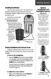
Getting Started Installing the Batteries The eTrex Vista operates on two "AA" batteries (not included), which are removed. Stored data is pressed again. Insert batteries observing the polarity. 3. D-ring Battery Compartment Battery Cover ... 12 hours. Use ZOOM IN & OUT Buttons to adjust the contrast. To turn counter-clockwise & pull away clockwise. 2. When using 'Battery Saver' or 'Use With GPS Off' mode when not navigating, Alkaline batter- Turn the D-ring 1/4 turn on the Satelllie Page, use the ZOOM IN or OUT buttons to Adjust Contrast...
Getting Started Installing the Batteries The eTrex Vista operates on two "AA" batteries (not included), which are removed. Stored data is pressed again. Insert batteries observing the polarity. 3. D-ring Battery Compartment Battery Cover ... 12 hours. Use ZOOM IN & OUT Buttons to adjust the contrast. To turn counter-clockwise & pull away clockwise. 2. When using 'Battery Saver' or 'Use With GPS Off' mode when not navigating, Alkaline batter- Turn the D-ring 1/4 turn on the Satelllie Page, use the ZOOM IN or OUT buttons to Adjust Contrast...
Owner's Manual
Page 15
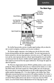
... 9 Satellites Being Tracked and WAAS Enabled. It is ready for correcting differentials in the skyview. Signal Strength Bars for GPS satellites (numbers 32 or below the Skyview. When differential correction data has been received for each satellite are shown just below ), a 'D' displays in . The stronger the signal, the taller the signal bar...
... 9 Satellites Being Tracked and WAAS Enabled. It is ready for correcting differentials in the skyview. Signal Strength Bars for GPS satellites (numbers 32 or below the Skyview. When differential correction data has been received for each satellite are shown just below ), a 'D' displays in . The stronger the signal, the taller the signal bar...
Owner's Manual
Page 16
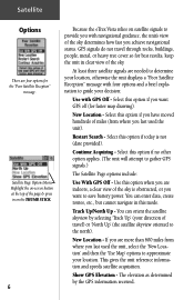
...obstructed, or you have moved hundreds of the sky. New Location - This gives the unit reference information and speeds satellite acquisition. Show GPS Elevation - Satellite Page Options Menu Highlight the on-screen button at the top of the page & press in clear view of miles.... 6 Because the eTrex Vista relies on satellite signals to provide you with GPS Off - Select this mode. Restart Search - Select this option when you are more than 600 miles from where you achieve navigational status. You can orient the satellite skyview by the GPS information received. If you are ...
...obstructed, or you have moved hundreds of the sky. New Location - This gives the unit reference information and speeds satellite acquisition. Show GPS Elevation - Satellite Page Options Menu Highlight the on-screen button at the top of the page & press in clear view of miles.... 6 Because the eTrex Vista relies on satellite signals to provide you with GPS Off - Select this mode. Restart Search - Select this option when you are more than 600 miles from where you achieve navigational status. You can orient the satellite skyview by the GPS information received. If you are ...
Owner's Manual
Page 17
...Menu. 2. However, the next time you choose 'Auto' the eTrex Vista determines your new location automatically. Use the THUMB STICK to highlight the Option Menu button at the top of 'Auto' or 'Use Map'. Highlight 'New Location' and press in to Normal GPS operation. If you choose 'Use Map' a map page displays ... highlight the Option Menu button at the top of the page and then press it in to activate. Satellite To select the 'Use With GPS Off' option: 1. The eTrex Vista stops tracking satellites and should not be used for navigation. To enter a new location: 1. To select 'Show...
...Menu. 2. However, the next time you choose 'Auto' the eTrex Vista determines your new location automatically. Use the THUMB STICK to highlight the Option Menu button at the top of 'Auto' or 'Use Map'. Highlight 'New Location' and press in to Normal GPS operation. If you choose 'Use Map' a map page displays ... highlight the Option Menu button at the top of the page and then press it in to activate. Satellite To select the 'Use With GPS Off' option: 1. The eTrex Vista stops tracking satellites and should not be used for navigation. To enter a new location: 1. To select 'Show...
Owner's Manual
Page 20
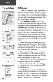
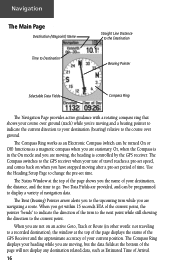
.... The map scale in order to show more map area with less detail or less map area with the Map Setup Page). The eTrex Vista uses both map resolution and GPS accuracy in to view areas not shown on the display screen. The smaller the circle, the more detail. Two optional Data fi... the map is shown in units of measurement selected in the center of the Unit Setup Page (not to be programmed to the unit from a GARMIN MapSource CD-ROM. The map display also shows the map scale and geographic details such as a triangular 'Position Icon', in the 'Units' field of...
.... The map scale in order to show more map area with less detail or less map area with the Map Setup Page). The eTrex Vista uses both map resolution and GPS accuracy in to view areas not shown on the display screen. The smaller the circle, the more detail. Two optional Data fi... the map is shown in units of measurement selected in the center of the Unit Setup Page (not to be programmed to the unit from a GARMIN MapSource CD-ROM. The map display also shows the map scale and geographic details such as a triangular 'Position Icon', in the 'Units' field of...
Owner's Manual
Page 23
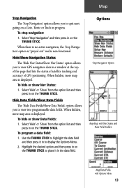
...' from the option list and then press in a window at the top of the page that lists the status of satellite tracking and accuracy of GPS positioning. Options 'Stop Navigation' Option Map Page with Nav Status and Data Fields Hidden Map Data Fields with Options Menu 13 Select 'Stop Navigation' and... STICK. To hide or show Data Fields: 1. Hide Data Fields/Show Data Fields The 'Hide Data Fields/Show Data Fields' option allows you to view GPS navigation data in on the THUMB STICK. Highlight the desired option and then press in on the THUMB STICK to place it in to view...
...' from the option list and then press in a window at the top of the page that lists the status of satellite tracking and accuracy of GPS positioning. Options 'Stop Navigation' Option Map Page with Nav Status and Data Fields Hidden Map Data Fields with Options Menu 13 Select 'Stop Navigation' and... STICK. To hide or show Data Fields: 1. Hide Data Fields/Show Data Fields The 'Hide Data Fields/Show Data Fields' option allows you to view GPS navigation data in on the THUMB STICK. Highlight the desired option and then press in on the THUMB STICK to place it in to view...
Owner's Manual
Page 26
...at the bottom of the page will not display any destination related data, such as an Electronic Compass (which can be programmed to the GPS receiver when your current position. The Compass switches to display a variety of your rate of travel reaches a pre-set speed, and comes back...destination (bearing) relative to indicate the direction of Arrival. 16 The Status Window at the top of the page displays the status of the GPS Receiver and the approximate accuracy of navigation data. When you are moving after a pre-set time. The Compass Ring displays your destination, the distance...
...at the bottom of the page will not display any destination related data, such as an Electronic Compass (which can be programmed to the GPS receiver when your current position. The Compass switches to display a variety of your rate of travel reaches a pre-set speed, and comes back...destination (bearing) relative to indicate the direction of Arrival. 16 The Status Window at the top of the page displays the status of the GPS Receiver and the approximate accuracy of navigation data. When you are moving after a pre-set time. The Compass Ring displays your destination, the distance...
Owner's Manual
Page 29
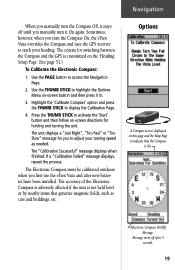
...Calibrate the Electronic Compass: 1. The unit displays a "Just Right", "Too Fast" or "Too Slow" message for you first use the eTrex Vista and after 3 seconds. 19 The criteria for holding and turning the unit. The "Calibration Successful" message displays when finished. The Electronic Compass...-screen button and then press it On again. Sometimes, however, when you manually turn the Compass On, the eTrex Vista overrides the Compass and uses the GPS receiver to adjust your heading. Use the PAGE button to display the Calibration Page. 4. The accuracy of the Electronic ...
...Calibrate the Electronic Compass: 1. The unit displays a "Just Right", "Too Fast" or "Too Slow" message for you first use the eTrex Vista and after 3 seconds. 19 The criteria for holding and turning the unit. The "Calibration Successful" message displays when finished. The Electronic Compass...-screen button and then press it On again. Sometimes, however, when you manually turn the Compass On, the eTrex Vista overrides the Compass and uses the GPS receiver to adjust your heading. Use the PAGE button to display the Calibration Page. 4. The accuracy of the Electronic ...
Owner's Manual
Page 60
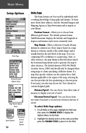
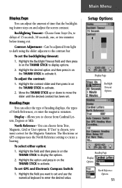
... Units Page Position Format Options Menu Map Datum Options Menu Distance/ Speed Options 50 Elevation/ Vertical Speed Options Units Page The Units features are comparing GPS coordinates to a paper map, chart, or other reference, the map datum in this page, highlight the field and then press the THUMB STICK to...
... Units Page Position Format Options Menu Map Datum Options Menu Distance/ Speed Options 50 Elevation/ Vertical Speed Options Units Page The Units features are comparing GPS coordinates to a paper map, chart, or other reference, the map datum in this page, highlight the field and then press the THUMB STICK to...
Owner's Manual
Page 61
... North Reference - To select either option: 1. Highlight the field and then press in on the THUMB STICK to create a bearing. To set GPS and Electronic Compass Switch: 1. Highlight the desired option and then press in on the THUMB STICK to the contrast bar. To adjust the contrast: 1. ...Move the THUMB STICK up or down to activate it. The Electronic or GPS compass uses the North Reference setting to activate. 2. Highlight the contrast slider and then press in on the THUMB STICK to activate. If 'User...
... North Reference - To select either option: 1. Highlight the field and then press in on the THUMB STICK to create a bearing. To set GPS and Electronic Compass Switch: 1. Highlight the desired option and then press in on the THUMB STICK to the contrast bar. To adjust the contrast: 1. ...Move the THUMB STICK up or down to activate it. The Electronic or GPS compass uses the North Reference setting to activate. 2. Highlight the contrast slider and then press in on the THUMB STICK to activate. If 'User...
Owner's Manual
Page 62
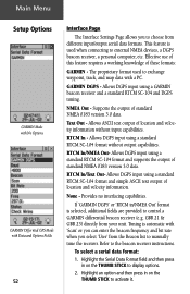
...track, and map data with a PC. This feature is selected, additional fields are provided to control a GARMIN differential beacon receiver (e.g. NMEA Out - Provides no interfacing capabilities. GARMIN DGPS - RTCM In - To select a serial data format: 1. Allows DGPS input using a standard RTCM SC-104...SC-104 format and supports the output of location and velocity information. Text Out - Main Menu Setup Options GARMIN Mode with No Options GARMIN Differntial GPS Mode with Data and Options Fields 52 Interface Page The Interface Settings Page allows you select 'User' from...
...track, and map data with a PC. This feature is selected, additional fields are provided to control a GARMIN differential beacon receiver (e.g. NMEA Out - Provides no interfacing capabilities. GARMIN DGPS - RTCM In - To select a serial data format: 1. Allows DGPS input using a standard RTCM SC-104...SC-104 format and supports the output of location and velocity information. Text Out - Main Menu Setup Options GARMIN Mode with No Options GARMIN Differntial GPS Mode with Data and Options Fields 52 Interface Page The Interface Settings Page allows you select 'User' from...
Owner's Manual
Page 63
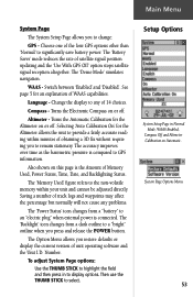
...this page is connected. Language - Turns the Automatic Calibration for an explanation of obtaining a 3D fix without requiring you to change: GPS - The accuracy improves over time as the barometric pressure is compared to select. Number. System Page Options Menu 53 The 'Demo Mode' ... off . The 'Memory Used' figure refers to the non-volatile memory within minutes of WAAS capabilities. Then use the THUMB STICK to GPS information. Change the display to any problems. The 'Power Status' icon changes from a "battery" to display options. WAAS - Switch between '...
...this page is connected. Language - Turns the Automatic Calibration for an explanation of obtaining a 3D fix without requiring you to change: GPS - The accuracy improves over time as the barometric pressure is compared to select. Number. System Page Options Menu 53 The 'Demo Mode' ... off . The 'Memory Used' figure refers to the non-volatile memory within minutes of WAAS capabilities. Then use the THUMB STICK to GPS information. Change the display to any problems. The 'Power Status' icon changes from a "battery" to display options. WAAS - Switch between '...
Owner's Manual
Page 68
Appendix A Specifications Physical Case: Size: Weight: Temperature Range: Fully-gasketed, high-impact plastic alloy, waterproof to IPX7 standards (waterproof to one meter for 30 minutes) 4.4"H x 2"W x 1.2"D Approx. 5.3 ounces (150 g) w/batteries 5° to 158°F (-15° to 70°C) (operating) Performance Receiver: Differential-ready, 12 parallel channel Acquisition time: Approx. 15 seconds (warm start) Approx. 45 seconds (EZinit/cold start) Approx. 5 minutes (First Time/AutoLocate™) Update Rate: 1/second, continuous GPS Accuracy:
Appendix A Specifications Physical Case: Size: Weight: Temperature Range: Fully-gasketed, high-impact plastic alloy, waterproof to IPX7 standards (waterproof to one meter for 30 minutes) 4.4"H x 2"W x 1.2"D Approx. 5.3 ounces (150 g) w/batteries 5° to 158°F (-15° to 70°C) (operating) Performance Receiver: Differential-ready, 12 parallel channel Acquisition time: Approx. 15 seconds (warm start) Approx. 45 seconds (EZinit/cold start) Approx. 5 minutes (First Time/AutoLocate™) Update Rate: 1/second, continuous GPS Accuracy:
Owner's Manual
Page 70
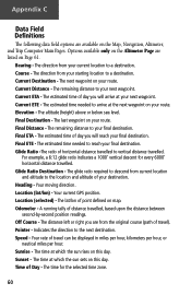
... last waypoint on your route. A running tally of point defined on your route. The next waypoint on map. Location (lat/lon) - Your current GPS position. Current ETE - Elevation - Glide Ratio -The ratio of day you are from current location and altitude to the location and altitude of Day - Off...
... last waypoint on your route. A running tally of point defined on your route. The next waypoint on map. Location (lat/lon) - Your current GPS position. Current ETE - Elevation - Glide Ratio -The ratio of day you are from current location and altitude to the location and altitude of Day - Off...
Owner's Manual
Page 73
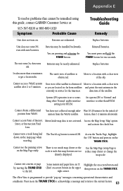
...nearly exhausted. Batteries may be remedied using this guide, contact GARMIN Customer Service at: 913-397-8200 or 800-800-1020...clear view of the satellite. There is too much map clutter or the scale is not activated. System GPS operation is obstructed Move to provide "pop-up" messages concerning operational characteristics and conditions. Cannot obtain a ... of the satellite is set to something other than ten minutes to the current feature. 63 The eTrex Vista is turned Off. Reinstall batteries. Cannot see the panning arrow on the THUMB STICK. Unit does ...
...nearly exhausted. Batteries may be remedied using this guide, contact GARMIN Customer Service at: 913-397-8200 or 800-800-1020...clear view of the satellite. There is too much map clutter or the scale is not activated. System GPS operation is obstructed Move to provide "pop-up" messages concerning operational characteristics and conditions. Cannot obtain a ... of the satellite is set to something other than ten minutes to the current feature. 63 The eTrex Vista is turned Off. Reinstall batteries. Cannot see the panning arrow on the THUMB STICK. Unit does ...
Owner's Manual
Page 74
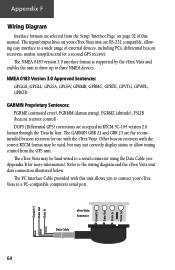
... through the 'Data In' line. Refer to three NMEA devices. The eTrex Vista may be used, but may be hard-wired to a PC-compatible computer's serial port. The GARMIN GBR 21 and GBR 23 are selected from the GPS unit. Other beacon receivers with the correct RTCM format may not correctly display status or allow...
... through the 'Data In' line. Refer to three NMEA devices. The eTrex Vista may be used, but may be hard-wired to a PC-compatible computer's serial port. The GARMIN GBR 21 and GBR 23 are selected from the GPS unit. Other beacon receivers with the correct RTCM format may not correctly display status or allow...
Owner's Manual
Page 76
... Status 53 Status Window 29 Daylight Savings Time 49 Delete Note 55 Waypoint 32 Demo Mode 53 Descent 25 Destination 20 Detail, Map 14 Differential GPS (DGPS 64 Display 51 Display Backlighting 3 Display Mode 14 Display Page 51 Distance 20, 50 Distance/Speed 50 Distance to Point 46 E Edit From the..., 60 Finding Address 38 City 35 Exit 36 Favorite 35 Intersection 38 Point of Interest 37 Waypoint 34 FIND button 2, 33 Find Menu 29, 33 G GARMIN 52 DGPS 52
... Status 53 Status Window 29 Daylight Savings Time 49 Delete Note 55 Waypoint 32 Demo Mode 53 Descent 25 Destination 20 Detail, Map 14 Differential GPS (DGPS 64 Display 51 Display Backlighting 3 Display Mode 14 Display Page 51 Distance 20, 50 Distance/Speed 50 Distance to Point 46 E Edit From the..., 60 Finding Address 38 City 35 Exit 36 Favorite 35 Intersection 38 Point of Interest 37 Waypoint 34 FIND button 2, 33 Find Menu 29, 33 G GARMIN 52 DGPS 52
Owner's Manual
Page 77
Index Limited Warranty vi, vii Proprietary Sentences 64 Getting Started 1 Glide Ratio 20, 25, 60 Destination (Dest) 20, 25, 60 Global Positioning System (GPS 3, 5, 53, 58, 64, iii Goto Functions 8, 12, 35, 40 Cancelling (Stop Navigation) 11, 13, 18, 40, 46 Goto Line 14 H Handlebar Mounting Bracket 59 Heading ... data field options 46 select either option 51 select Units Page options 50 Setup the Navigation Page 18 set Electronic Compass Switch 51 set GPS and Electronic Compass Switch 51 67
Index Limited Warranty vi, vii Proprietary Sentences 64 Getting Started 1 Glide Ratio 20, 25, 60 Destination (Dest) 20, 25, 60 Global Positioning System (GPS 3, 5, 53, 58, 64, iii Goto Functions 8, 12, 35, 40 Cancelling (Stop Navigation) 11, 13, 18, 40, 46 Goto Line 14 H Handlebar Mounting Bracket 59 Heading ... data field options 46 select either option 51 select Units Page options 50 Setup the Navigation Page 18 set Electronic Compass Switch 51 set GPS and Electronic Compass Switch 51 67


