
Owner's Manual
Page 21
...Method-distance records track points after a specified time has elapsed. Time creates track points after a specified distance is traveled. Basic Operation • Color-select the color of the microSD card). Press MENU twice > Tracks. 2 Select Save. Press MENU twice > Tracks. 2. Select Setup. Using this option...number of track points (depending on the capacity of the active track on the data card are .gpx GPS position data files, and are not used by your unit. eTrex HC series Owner's Manual 17 Auto (recommended) allows you to the Record Method and Interval. Enter a ...
...Method-distance records track points after a specified time has elapsed. Time creates track points after a specified distance is traveled. Basic Operation • Color-select the color of the microSD card). Press MENU twice > Tracks. 2 Select Save. Press MENU twice > Tracks. 2. Select Setup. Using this option...number of track points (depending on the capacity of the active track on the data card are .gpx GPS position data files, and are not used by your unit. eTrex HC series Owner's Manual 17 Auto (recommended) allows you to the Record Method and Interval. Enter a ...
Owner's Manual
Page 28
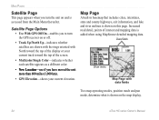
...screen. • Multicolor/Single Color-indicates whether each satellite appears as a different color. • New Location-use if you have moved the unit more than 600 miles (1,000 km). • GPS Elevation-shows your current track... the top of the display or your current elevation. Satellite Page Options • Use With GPS Off/On-enables you to turn the unit on and is accessed from the Main Menu... thereafter. Main Pages Satellite Page This page appears when you turn the GPS receiver on or off. • Track Up/North Up-indicates whether satellites are shown with ...
...screen. • Multicolor/Single Color-indicates whether each satellite appears as a different color. • New Location-use if you have moved the unit more than 600 miles (1,000 km). • GPS Elevation-shows your current track... the top of the display or your current elevation. Satellite Page Options • Use With GPS Off/On-enables you to turn the unit on and is accessed from the Main Menu... thereafter. Main Pages Satellite Page This page appears when you turn the GPS receiver on or off. • Track Up/North Up-indicates whether satellites are shown with ...
Owner's Manual
Page 41
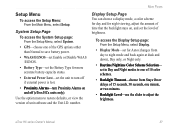
...battery power. • WAAS/EGNOS-set Enable or Disable WAAS /EGNOS. • Battery Type-set in Day and Night modes to one of 10 color schemes. • Backlight Timeout-choose from day to adjust the brightness. set the Battery Type for night viewing, adjust the amount of time that ...status. • External Power Lost-set the level of unit software and the Unit I.D. eTrex HC series Owner's Manual 37 System Setup Page To access the System Setup page: From the Setup Menu, select System. • GPS-choose one minute, or two minutes. • Backlight Level-use the slider to night ...
...battery power. • WAAS/EGNOS-set Enable or Disable WAAS /EGNOS. • Battery Type-set in Day and Night modes to one of 10 color schemes. • Backlight Timeout-choose from day to adjust the brightness. set the Battery Type for night viewing, adjust the amount of time that ...status. • External Power Lost-set the level of unit software and the Unit I.D. eTrex HC series Owner's Manual 37 System Setup Page To access the System Setup page: From the Setup Menu, select System. • GPS-choose one minute, or two minutes. • Backlight Level-use the slider to night ...
Owner's Manual
Page 49
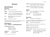
Display: 1.3" W x 1.7" H, 256-color, high resolution, transreflective TFT(176 x 220 pixels) backlit. Appendix Appendix Compass: (Vista HCx/Summit HC only) Accuracy; +/- 5 degrees, resolution; 1 degree, user calibrated Specifications Physical Size: 4.2" H x 2.2" W x 1.2" D Weight: 5.6 ounces (159 g) with batteries ... Rugged, fully gasketed, water resistant, IEC-529, IPX7 Temp: 5 to 158°F (-15 to 70° C)* Altimeter: (Vista HCx/Summit HC only) Accuracy; +/- 10 feet, resolution; 1 ft., user calibrated Power Source: Two 1.5 volt AA batteries, 12 V DC Adapter Cable, or PC...
Display: 1.3" W x 1.7" H, 256-color, high resolution, transreflective TFT(176 x 220 pixels) backlit. Appendix Appendix Compass: (Vista HCx/Summit HC only) Accuracy; +/- 5 degrees, resolution; 1 degree, user calibrated Specifications Physical Size: 4.2" H x 2.2" W x 1.2" D Weight: 5.6 ounces (159 g) with batteries ... Rugged, fully gasketed, water resistant, IEC-529, IPX7 Temp: 5 to 158°F (-15 to 70° C)* Altimeter: (Vista HCx/Summit HC only) Accuracy; +/- 10 feet, resolution; 1 ft., user calibrated Power Source: Two 1.5 volt AA batteries, 12 V DC Adapter Cable, or PC...
Quick Reference Guide
Page 1
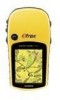
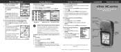
... Copyright 2007 Garmin Ltd. or its subsidiaries Printed in Taiwan Quick Start Guide eTrex® HC series Vista HCx, Legend HCx, Summit HC, and Venture HC GPS antenna IN/OUT (Zoom) keys ENTER/ROCKER key MENU/FIND key QUIT/ PAGE key POWER/ Backlight key Color LCD display (eTrex Vista HCx shown) (eTrex Vista HCx shown...: For the Find Menu to display all of the categories shown above, MapSource® detailed map data must be downloaded to the eTrex (Summit HC and Venture HC) or a microSD™ or TransFlash™ card (Vista HCx or Legend HCx). (Refer to select a waypoint, and press ENTER...
... Copyright 2007 Garmin Ltd. or its subsidiaries Printed in Taiwan Quick Start Guide eTrex® HC series Vista HCx, Legend HCx, Summit HC, and Venture HC GPS antenna IN/OUT (Zoom) keys ENTER/ROCKER key MENU/FIND key QUIT/ PAGE key POWER/ Backlight key Color LCD display (eTrex Vista HCx shown) (eTrex Vista HCx shown...: For the Find Menu to display all of the categories shown above, MapSource® detailed map data must be downloaded to the eTrex (Summit HC and Venture HC) or a microSD™ or TransFlash™ card (Vista HCx or Legend HCx). (Refer to select a waypoint, and press ENTER...


