Owner's Manual
Page 3
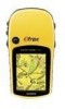
..., or a photocopy, in this package with a few exceptions. Introduction Introduction Thank you for all HC series units, a notation is not universal for choosing the Garmin® eTrex Vista® HCx, eTrex Legend® HCx, eTrex Summit® HC, or eTrex Venture® HC. In the USA contact Garmin Product Support by quickly pressing and releasing the POWER key. Optional ��A�...
..., or a photocopy, in this package with a few exceptions. Introduction Introduction Thank you for all HC series units, a notation is not universal for choosing the Garmin® eTrex Vista® HCx, eTrex Legend® HCx, eTrex Summit® HC, or eTrex Venture® HC. In the USA contact Garmin Product Support by quickly pressing and releasing the POWER key. Optional ��A�...
Owner's Manual
Page 7
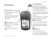
... Menu. enter data; Press and release for a page. From any time to move the map panning arrow. highlight fields, on or off (Vista HCx and Summit HC only). eTrex HC series Owner's Manual Getting Started ENTER/ROCKER key Rock up or down or right or left to MARK your current location as a waypoint. POWER...
... Menu. enter data; Press and release for a page. From any time to move the map panning arrow. highlight fields, on or off (Vista HCx and Summit HC only). eTrex HC series Owner's Manual Getting Started ENTER/ROCKER key Rock up or down or right or left to MARK your current location as a waypoint. POWER...
Owner's Manual
Page 9
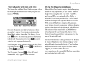
...Garmin Web site: www.garmin.com for or acquiring satellites , a 2D fix is attained and a 3D fix is depleted. Date/Time Window Power to the microSD card when installed in the eTrex. Getting Started Using the Mapping Databases Many of data transferable is 24 MB for the eTrex Summit HC and Venture HC...compatible MapSource products and pre-loaded microSD cards. The amount of the eTrex features require detailed mapping data to transfer maps before using the unit. The Electronic Compass (Vista HCx and Summit HC only) appears when activated. Use the USB Interface Cable, provided ...
...Garmin Web site: www.garmin.com for or acquiring satellites , a 2D fix is attained and a 3D fix is depleted. Date/Time Window Power to the microSD card when installed in the eTrex. Getting Started Using the Mapping Databases Many of data transferable is 24 MB for the eTrex Summit HC and Venture HC...compatible MapSource products and pre-loaded microSD cards. The amount of the eTrex features require detailed mapping data to transfer maps before using the unit. The Electronic Compass (Vista HCx and Summit HC only) appears when activated. Use the USB Interface Cable, provided ...
Owner's Manual
Page 10
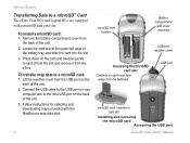
...a microSD card: 1. Remove the battery compartment cover from the batteries. To transfer map data to a microSD™ Card The eTrex Vista HCx and Legend HCx are equipped with cover removed PUSH TO EJECT USB port weather cover Accessing the microSD card slot Contacts on the back of the unit.... 2. USB port Taiwan PUSH TO EJECT microSD card inserted in card slot Installing and removing the microSD card Accessing the USB port eTrex HC...
...a microSD card: 1. Remove the battery compartment cover from the batteries. To transfer map data to a microSD™ Card The eTrex Vista HCx and Legend HCx are equipped with cover removed PUSH TO EJECT USB port weather cover Accessing the microSD card slot Contacts on the back of the unit.... 2. USB port Taiwan PUSH TO EJECT microSD card inserted in card slot Installing and removing the microSD card Accessing the USB port eTrex HC...
Owner's Manual
Page 13
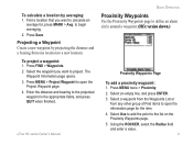
... item. 4. Select the waypoint you want to project. Enter the distance and bearing to define an alarm circle around a waypoint. (HCx version shown.) Proximity Waypoints Page To add a proximity waypoint: 1. eTrex HC series Owner's Manual Basic Operation Proximity Waypoints Use the Proximity Waypoints page to the projected waypoint in the appropriate fields, and...
... item. 4. Select the waypoint you want to project. Enter the distance and bearing to define an alarm circle around a waypoint. (HCx version shown.) Proximity Waypoints Page To add a proximity waypoint: 1. eTrex HC series Owner's Manual Basic Operation Proximity Waypoints Use the Proximity Waypoints page to the projected waypoint in the appropriate fields, and...
Owner's Manual
Page 14
... search options. Additional icons appear depending on or off: Press MENU twice > Proximity (eTrex HCx and HC units) > Proximity Alarm Tones (eTrex HCx units) and check or uncheck the Proximity Alarms box. Select a Category. 10 eTrex HC series Owner's Manual To remove all proximity waypoints from the list, press MENU > Remove... To clear one or all waypoints from the list: To remove a single entry, press ENTER. Select Proximity Alarm Tones (eTrex HCx units only). Use the setup page on the eTrex HC units is shown. The options menu for waypoints, geocaches, cities, and exits in the...
... search options. Additional icons appear depending on or off: Press MENU twice > Proximity (eTrex HCx and HC units) > Proximity Alarm Tones (eTrex HCx units) and check or uncheck the Proximity Alarms box. Select a Category. 10 eTrex HC series Owner's Manual To remove all proximity waypoints from the list, press MENU > Remove... To clear one or all waypoints from the list: To remove a single entry, press ENTER. Select Proximity Alarm Tones (eTrex HCx units only). Use the setup page on the eTrex HC units is shown. The options menu for waypoints, geocaches, cities, and exits in the...
Owner's Manual
Page 20
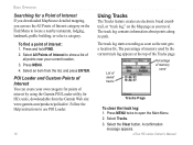
... on the Map page as the unit gets a location fix. A confirmation message appears. Press MENU. 4. Select an item from the Garmin Web site: www.garmin.com/products/poiloader/. The track log contains information about points along its path. Press MENU twice to show a list of the Tracks page...interest by the current track log appears at the top of all points near your own category for HCx units, downloadable from the list, and press ENTER. Select the Clear button. eTrex HC series Owner's Manual POI Loader and Custom Points of Interest You can use POI Loader. 16 ...
... on the Map page as the unit gets a location fix. A confirmation message appears. Press MENU. 4. Select an item from the Garmin Web site: www.garmin.com/products/poiloader/. The track log contains information about points along its path. Press MENU twice to show a list of the Tracks page...interest by the current track log appears at the top of all points near your own category for HCx units, downloadable from the list, and press ENTER. Select the Clear button. eTrex HC series Owner's Manual POI Loader and Custom Points of Interest You can use POI Loader. 16 ...

Owner's Manual
Page 21
Press MENU twice > Tracks. 2 Select Save. eTrex HC series Owner's Manual 17 Time creates track points after a specified distance is traveled. Basic ...appears asking you if you want to the unit's internal memory. Enter a specific distance, time, or frequency. Data card option (HCx units only) • Wrap When Full-the track log records over the oldest data with new data. • Record Method-distance...by your unit. Track logs on the map. • Log Track to Data Card-(HCx units only) records the current track log to the microSD card, in addition to save the entire track. 3.
Press MENU twice > Tracks. 2 Select Save. eTrex HC series Owner's Manual 17 Time creates track points after a specified distance is traveled. Basic ...appears asking you if you want to the unit's internal memory. Enter a specific distance, time, or frequency. Data card option (HCx units only) • Wrap When Full-the track log records over the oldest data with new data. • Record Method-distance...by your unit. Track logs on the map. • Log Track to Data Card-(HCx units only) records the current track log to the microSD card, in addition to save the entire track. 3.
Owner's Manual
Page 22
...As long as this feature is enabled, a new file is filled. 3. Open the track logs using Garmin MapSource or another .gpx file-compatible application. 4. Note: Do not remove the microSD card from the... microSD card, highlight individual logs, and then press ENTER. Select Save. 3. Repeat to an HCx unit microSD card: 1. Use the USB cable to connect the unit to be the beginning point, ... to move the pointer to the point on the track line that you use the unit. eTrex HC series Owner's Manual Recording continues until the card is recorded for the indicated date. Highlight the...
...As long as this feature is enabled, a new file is filled. 3. Open the track logs using Garmin MapSource or another .gpx file-compatible application. 4. Note: Do not remove the microSD card from the... microSD card, highlight individual logs, and then press ENTER. Select Save. 3. Repeat to an HCx unit microSD card: 1. Use the USB cable to connect the unit to be the beginning point, ... to move the pointer to the point on the track line that you use the unit. eTrex HC series Owner's Manual Recording continues until the card is recorded for the indicated date. Highlight the...
Owner's Manual
Page 23
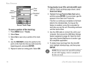
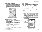
...Open the Saved Track page, and press MENU. 2. Saved track on , press MENU. 2. Press Enter to show profiles, if using the eTrex Summit HC or the eTrex Vista HCx. Basic Operation To view a track on the page. 4. Refer to use Zoom Ranges and Hide Symbols options. Select Area Calculation, and press... ENTER. 3. Press MENU to the Garmin Web site for information about these maps. Use the ROCKER to the track. Select Profile. A ...
...Open the Saved Track page, and press MENU. 2. Saved track on , press MENU. 2. Press Enter to show profiles, if using the eTrex Summit HC or the eTrex Vista HCx. Basic Operation To view a track on the page. 4. Refer to use Zoom Ranges and Hide Symbols options. Select Area Calculation, and press... ENTER. 3. Press MENU to the Garmin Web site for information about these maps. Use the ROCKER to the track. Select Profile. A ...
Owner's Manual
Page 24
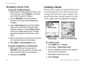
.... 3. Select Navigate. With the Saved Tracks page for the track or the Track Log open, select TracBack, to each . Select Follow Road (HCx units with up to 250 points each turn , directions to show the track. Select Use to add it to select a route waypoint from one... of travel. Use the Find Menu to the route. 5. eTrex HC series Owner's Manual Select the point to exit. Select Menu > Stop Navigation to TracBack. 2. To create a waypoint on the track. 4. Create complex ...
.... 3. Select Navigate. With the Saved Tracks page for the track or the Track Log open, select TracBack, to each . Select Follow Road (HCx units with up to 250 points each turn , directions to show the track. Select Use to add it to select a route waypoint from one... of travel. Use the Find Menu to the route. 5. eTrex HC series Owner's Manual Select the point to exit. Select Menu > Stop Navigation to TracBack. 2. To create a waypoint on the track. 4. Create complex ...
Owner's Manual
Page 25
..., "Follow Road" or "Off Road." Select Off Road to point. • When using an eTrex HCx unit, both navigation methods change when you select the Follow Roads option on Map Page eTrex HC series Owner's Manual 21 Press MENU twice > Routes. 2. Both Go To navigation and point-to-...point allow you are preceded by a guidance message with the eTrex Vista HCx and Legend HCx.) This feature is complete. To stop navigating, press...
..., "Follow Road" or "Off Road." Select Off Road to point. • When using an eTrex HCx unit, both navigation methods change when you select the Follow Roads option on Map Page eTrex HC series Owner's Manual 21 Press MENU twice > Routes. 2. Both Go To navigation and point-to-...point allow you are preceded by a guidance message with the eTrex Vista HCx and Legend HCx.) This feature is complete. To stop navigating, press...
Owner's Manual
Page 27
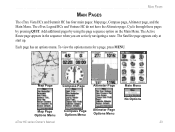
... pressing QUIT. The Satellite page appears only at start up. Main Pages Main Pages The eTrex Vista HCx and Summit HC has four main pages: Map page, Compass page, Altimeter page, and the Main Menu. The eTrex Legend HCx and Venture HC do not have the Altimeter page. The Active Route page appears in the sequence when... a page, press MENU. Map Page Compass Page Altimeter Page Main Menu No Options Map Page Options Menu Compass Page Options Menu Altimeter Page Options Menu eTrex HC series Owner's Manual 23
... pressing QUIT. The Satellite page appears only at start up. Main Pages Main Pages The eTrex Vista HCx and Summit HC has four main pages: Map page, Compass page, Altimeter page, and the Main Menu. The eTrex Legend HCx and Venture HC do not have the Altimeter page. The Active Route page appears in the sequence when... a page, press MENU. Map Page Compass Page Altimeter Page Main Menu No Options Map Page Options Menu Compass Page Options Menu Altimeter Page Options Menu eTrex HC series Owner's Manual 23

Owner's Manual
Page 32
...the numeric keypad to get an accurate electronic compass reading. to compass heading when below.... 4. The accuracy of the eTrex HC series units use the Vista HCx or Summit HC. Main Pages Using the Electronic Compass (All of the electronic compass is also adversely affected if the unit is not... Calibrating the Electronic Compass Calibrate the electronic compass outdoors when you are near objects that affect magnetic fields, such as cars or buildings. 28 eTrex HC series Owner's Manual When it off , the unit uses the GPS receiver for Compass Auto On and Off: 1. Press Menu twice > ...
...the numeric keypad to get an accurate electronic compass reading. to compass heading when below.... 4. The accuracy of the eTrex HC series units use the Vista HCx or Summit HC. Main Pages Using the Electronic Compass (All of the electronic compass is also adversely affected if the unit is not... Calibrating the Electronic Compass Calibrate the electronic compass outdoors when you are near objects that affect magnetic fields, such as cars or buildings. 28 eTrex HC series Owner's Manual When it off , the unit uses the GPS receiver for Compass Auto On and Off: 1. Press Menu twice > ...
Owner's Manual
Page 33
... data fields. • Calibrate Compass-accesses the compass Calibration page (Vista HCx and Summit HC only). • Restore Defaults-returns to adjust your sight (Vista HCx and Summit HC only). • Stop/Resume Navigation-turns active navigation for holding and turning the unit. eTrex HC series Owner's Manual 29 With Start selected, press ENTER, and follow...
... data fields. • Calibrate Compass-accesses the compass Calibration page (Vista HCx and Summit HC only). • Restore Defaults-returns to adjust your sight (Vista HCx and Summit HC only). • Stop/Resume Navigation-turns active navigation for holding and turning the unit. eTrex HC series Owner's Manual 29 With Start selected, press ENTER, and follow...
Owner's Manual
Page 34
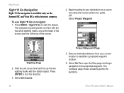
...the top of the screen. 4. Press ENTER to the projected waypoint. Enter an estimated distance from your destination on the Summit HC and Vista HCx with electronic compass. Select Go To to open the Map page and begin navigation to lock the direction. 3. Begin traveling to... your current location to establish a projected waypoint location. 6. eTrex HC series Owner's Manual Press MENU > Sight 'N Go to navigate: 1. The Compass page shows a bearing...
...the top of the screen. 4. Press ENTER to the projected waypoint. Enter an estimated distance from your destination on the Summit HC and Vista HCx with electronic compass. Select Go To to open the Map page and begin navigation to lock the direction. 3. Begin traveling to... your current location to establish a projected waypoint location. 6. eTrex HC series Owner's Manual Press MENU > Sight 'N Go to navigate: 1. The Compass page shows a bearing...
Owner's Manual
Page 36
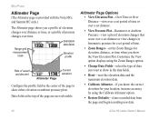
Main Pages Altimeter Page (The Altimeter page is provided with the Vista HCx and Summit HC only.) The Altimeter page shows you show the View Elevation Plot. Altimeter Page Options • View Elevation Plot-Over Time or Over Distance-view over a .... Customize the View option displays using the Calibrate Altimeter option. • Restore Defaults-clears recorded data from the page and begin recording new data. 32 eTrex HC series Owner's Manual Data fields at the top of pressure changes over distance or time, or a profile of the page are user selectable.
Main Pages Altimeter Page (The Altimeter page is provided with the Vista HCx and Summit HC only.) The Altimeter page shows you show the View Elevation Plot. Altimeter Page Options • View Elevation Plot-Over Time or Over Distance-view over a .... Customize the View option displays using the Calibrate Altimeter option. • Restore Defaults-clears recorded data from the page and begin recording new data. 32 eTrex HC series Owner's Manual Data fields at the top of pressure changes over distance or time, or a profile of the page are user selectable.
Owner's Manual
Page 41
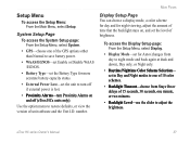
... the Setup Menu, select Display. • Display Mode-set the level of unit software and the Unit I.D. Use the option menu to turn off (eTrex HCx units only). eTrex HC series Owner's Manual 37 number. Main Pages Display Setup Page You can choose a display mode, a color scheme for day and for more accurate battery...
... the Setup Menu, select Display. • Display Mode-set the level of unit software and the Unit I.D. Use the option menu to turn off (eTrex HCx units only). eTrex HC series Owner's Manual 37 number. Main Pages Display Setup Page You can choose a display mode, a color scheme for day and for more accurate battery...
Owner's Manual
Page 42
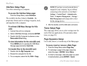
... card: Press Menu prior to add, remove, or reorder any of the Main pages. After the transfer, end the USB cable connection. eTrex HC series Owner's Manual To activate �USB Mass Storage for the storage device. 4. For a computer, select the file, Edit > Copy... exchange waypoint, track, and map data with a computer. To transfer files to observe a new Removable Drive listing. The available interface format is Garmin-the proprietary format used to the network or click Start > Settings > Control Panel > Administrative Tools > Computer Management > Storage > Disk Management...
... card: Press Menu prior to add, remove, or reorder any of the Main pages. After the transfer, end the USB cable connection. eTrex HC series Owner's Manual To activate �USB Mass Storage for the storage device. 4. For a computer, select the file, Edit > Copy... exchange waypoint, track, and map data with a computer. To transfer files to observe a new Removable Drive listing. The available interface format is Garmin-the proprietary format used to the network or click Start > Settings > Control Panel > Administrative Tools > Computer Management > Storage > Disk Management...
Owner's Manual
Page 45
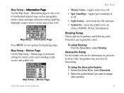
Map Setup - Map Setup - eTrex HC series Owner's Manual 41 I�n�f�o�r�m�...; Light Sectors-select from On, Off, and Auto. • Symbol Set-select the symbol set to use (Auto, GARMIN, NOAA, International). Marine Page Main Pages • Marine Colors-toggles colors on or off. • Spot Soundings-toggles ...and symbol sets. To setup the Geocache feature: 1. Highlight a map to show it on geocache locations: http://my.garmin.com, and click Go Geocaching. Map Setup - Select the symbol fields if you want to customize settings for displaying...
Map Setup - Map Setup - eTrex HC series Owner's Manual 41 I�n�f�o�r�m�...; Light Sectors-select from On, Off, and Auto. • Symbol Set-select the symbol set to use (Auto, GARMIN, NOAA, International). Marine Page Main Pages • Marine Colors-toggles colors on or off. • Spot Soundings-toggles ...and symbol sets. To setup the Geocache feature: 1. Highlight a map to show it on geocache locations: http://my.garmin.com, and click Go Geocaching. Map Setup - Select the symbol fields if you want to customize settings for displaying...

