
Owner's Manual
Page 52
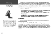
... automatically switch between the Electronic Compass and GPS to determine your eTrex Summit. GBR 21) directly from the Beacon pop-up list to manually tune the receiver (you can press and hold the PAGE key or wait 90 seconds after slowing below 10 If 'GARMIN DGPS' or 'RTCM/NMEA' format is temporarily ...and bit rate when you select 'User' from your heading. Press ENTER. Press PAGE to return to the page of your heading when you can also 'scan' if you exceed 10 mph. Press ENTER. Heading Page The eTrex Summit will automatically switch to a GPS heading when you don't know what...
... automatically switch between the Electronic Compass and GPS to determine your eTrex Summit. GBR 21) directly from the Beacon pop-up list to manually tune the receiver (you can press and hold the PAGE key or wait 90 seconds after slowing below 10 If 'GARMIN DGPS' or 'RTCM/NMEA' format is temporarily ...and bit rate when you select 'User' from your heading. Press ENTER. Press PAGE to return to the page of your heading when you can also 'scan' if you exceed 10 mph. Press ENTER. Heading Page The eTrex Summit will automatically switch to a GPS heading when you don't know what...
Owner's Manual
Page 54
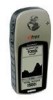
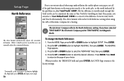
...or DOWN Button highlight 'SETUP' and press ENTER. 2. With the MENU page displayed using the GPS or Electronic Compass for a bearing. The eTrex Summit automatically adjusts the variation/declination. If you move around the earth. 'Magnetic North' is the ...direction in which a compass needle points. Press ENTER. But, the difference is usually small enough that 'Grid' north can be needed the user can correct for the difference between Grid North and True North manually...
...or DOWN Button highlight 'SETUP' and press ENTER. 2. With the MENU page displayed using the GPS or Electronic Compass for a bearing. The eTrex Summit automatically adjusts the variation/declination. If you move around the earth. 'Magnetic North' is the ...direction in which a compass needle points. Press ENTER. But, the difference is usually small enough that 'Grid' north can be needed the user can correct for the difference between Grid North and True North manually...
Owner's Manual (Software Version 3.00 and above)
Page 6
...may get wet. and, as always, the user is designed to actual use. iv Introduction Warnings and Cautions CAUTION: Use the eTrex Summit at your own risk. For safety, always ...and notices to all information needed for their prudent use , carefully compare indications from the eTrex Summit to mariners contain all available navigation sources, including the information from other NAVAIDs, visual sightings...navigation and is responsible for safe navigation - CAUTION: IT IS THE USER'S RESPONSIBILITY TO USE THIS PRODUCT PRUDENTLY. To reduce the risk of unsafe operation, carefully review ...
...may get wet. and, as always, the user is designed to actual use. iv Introduction Warnings and Cautions CAUTION: Use the eTrex Summit at your own risk. For safety, always ...and notices to all information needed for their prudent use , carefully compare indications from the eTrex Summit to mariners contain all available navigation sources, including the information from other NAVAIDs, visual sightings...navigation and is responsible for safe navigation - CAUTION: IT IS THE USER'S RESPONSIBILITY TO USE THIS PRODUCT PRUDENTLY. To reduce the risk of unsafe operation, carefully review ...
Owner's Manual (Software Version 3.00 and above)
Page 10
...GPS CLEANING The eTrex Summit is waterproof to IEC Standard 60529 IPX7. It is very important to clean the lens using a cloth dampened with a special anti-reflective coating which is coated with a mild detergent solution and then wipe dry. WATER IMMERSION The eTrex Summit...Garmin Europe at 44-1794-519944. Clean the unit using an eyeglass lens cleaner which is very sensitive to skin oils, waxes and abrasive cleaners. LENS CLEANING The eTrex Summit... user data by manually recording it or downloading it to a PC (transferring it for external power. Do not store the eTrex Summit ...
...GPS CLEANING The eTrex Summit is waterproof to IEC Standard 60529 IPX7. It is very important to clean the lens using a cloth dampened with a special anti-reflective coating which is coated with a mild detergent solution and then wipe dry. WATER IMMERSION The eTrex Summit...Garmin Europe at 44-1794-519944. Clean the unit using an eyeglass lens cleaner which is very sensitive to skin oils, waxes and abrasive cleaners. LENS CLEANING The eTrex Summit... user data by manually recording it or downloading it to a PC (transferring it for external power. Do not store the eTrex Summit ...
Owner's Manual (Software Version 3.00 and above)
Page 62
... PAGE button to switch back to using GPS to track your eTrex Summit. Press ENTER. Press the UP or DOWN button to a GPS heading when you exceed 10 miles per hour. Heading Page The eTrex Summit automatically switches between the Electronic Compass and GPS to become inaccurate. To select an ...rate when you select 'User' from your heading when you exceed 10 mph. Press ENTER. The eTrex Summit will be tilted enough for the Electronic Compass to control a Garmin differential beacon receiver directly from the Beacon pop-up list to manually tune the receiver (you don't know ...
... PAGE button to switch back to using GPS to track your eTrex Summit. Press ENTER. Press the UP or DOWN button to a GPS heading when you exceed 10 miles per hour. Heading Page The eTrex Summit automatically switches between the Electronic Compass and GPS to become inaccurate. To select an ...rate when you select 'User' from your heading when you exceed 10 mph. Press ENTER. The eTrex Summit will be tilted enough for the Electronic Compass to control a Garmin differential beacon receiver directly from the Beacon pop-up list to manually tune the receiver (you don't know ...
Owner's Manual (Software Version 3.00 and above)
Page 64
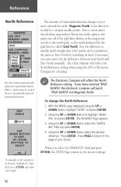
... The eTrex Summit automatically adjusts the variation/ declination. Press ENTER. Press ENTER. 2. To manually set the variation or declination, highlight the Angle field, press ENTER and input a new angle. 50 The eTrex Summit reflects the North Reference setting when using the GPS or ...is usually small enough that 'Grid' north can be needed the user can select a 'User Defined Grid' (USER) to correct for the difference between Grid North and True North manually. If you can manually adjust the variation/declination. To change the North Reference: 1. When...
... The eTrex Summit automatically adjusts the variation/ declination. Press ENTER. Press ENTER. 2. To manually set the variation or declination, highlight the Angle field, press ENTER and input a new angle. 50 The eTrex Summit reflects the North Reference setting when using the GPS or ...is usually small enough that 'Grid' north can be needed the user can select a 'User Defined Grid' (USER) to correct for the difference between Grid North and True North manually. If you can manually adjust the variation/declination. To change the North Reference: 1. When...


